

You are here
Avalanche Advisory for 2015-12-08 06:52:06
- EXPIRED ON December 9, 2015 @ 6:52 amPublished on December 8, 2015 @ 6:52 am
- Issued by Nick Meyers - Shasta-Trinity National Forest
Bottom Line
LOW avalanche danger exists for all aspects and elevations in the forecast area.
Normal caution is advised. Watch out for shallow buried objects!
Climbers: A winter climb of Mt Shasta up's the ante considerably. Avalanche danger, sub-zero temperatures and extreme weather can be encountered. It is your responsibility to be prepared for all aspects of winter mountaineering.


Avalanche Problem 1: Normal Caution
-
Character ?

-
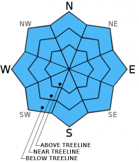
Aspect/Elevation ?
-
Likelihood ?CertainVery LikelyLikelyPossible
 Unlikely
 -
Size ?HistoricVery LargeLargeSmall

Avalanche concerns for today are little to none. Some loose wet activity could occur in steeper, extreme terrain, but a shallow snowpack will likely keep skiers and riders off this terrain anyways. Widespread consolidation of the snowpack occured yesterday due to rain and warm temperatures. Wind slabs near and above treeline in lee areas are not expected to present a significant hazard to backcountry riders. Our primary concern for today is the good chance of one bashing skis, knees, A-arms and other body areas on one or more of the shallow buried stumps, rocks and trees. Tread lightly!
Forecast Discussion
Light rain is forecast for the day, up to a tenth of an inch this morning, but otherwise today will serve as our "break" in the systems. We've experienced a drastic and all to familiar warming yesterday and today with some mist and rain on snow up to approximately 8,500 to 9,000 feet. Warm temps will continue for the next 36-48 hours. The next string of systems is on deck and will arrive tomorrow bringing a predicted 1-1.8 inches of precipitation for this first round. Lingering warm air will keep snow levels higher on Wednesday, 7,000 to 8,000 ft., however a large cold air mass will drop in and lower freezing levels to 4,500 feet on Thursday. Winds will remain reasonable below treeline and moderate above treeline today out of the south/southwest/west. Late Wednesday and Thursday look to bring the highest wind speeds, 50-60mph with gusts to 70-80 mph.
THIS SEASON PRECIPITATION: Since October 1st (the wet season), we have received 4.73 inches of water, normal is 8.97 inches, putting us at 52% of normal. For the month of December, we have received 2.70 inches of water, normal is 1.61 putting us at 167% of normal. For the year of 2015 we've received 21.91 inches of water, normal is 36.97 inches putting us at 59% of normal.
Recent Observations
Yesterday, light to moderate rain at times fell with the snow line upwards of 8,500 to 9,000 feet. This dramatic warm spell with precipitation did a heck of a job consolidating and squishing our snowpack. Two to four inches of settlement was recorded and rain runnels dominate across all aspects and elevations up to 9,000 feet. Loose wet avalanche activity was not observed, though some minor roller ball activity could occur. Needless to say, skiing conditions are on the "poor" side of the spectrum, though these conditions are creating a nice, solid base for the up and coming storms!
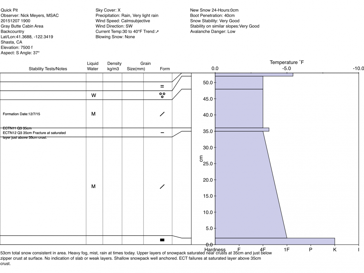
Below and near treeline, the snowpack remains shallow enough that I have yet to find a well developed slab due to ground anchors. We lack above treeline observations due to extremely poor visibility over the past few days. Brief glimpses of salt and pepper snow surface conditions indicate a shallow snowpack. Wind is almost always a factor on Mt Shasta above treeline, scouring many areas. Shallow, small to medium size wind slabs may be found in the usual areas: ridgetops, bowls and extreme terrain. Sensitivity of said slabs is unknown, so use cautious route finding, dig a pit, conduct a stability test!
A thin zipper crust on the surface of the snowpack was observed on southerly aspects yesterday. Also observed was a soft crust layer at 35cm from ground. Upper layers of the snowpack near crusts were saturated. Stability tests could not produce propagation, though fractures were initiated just above the 35cm crust in the saturated snow.
The Sand Flat cross country ski trails are snow covered and ready for your cross country skis. These are backcountry trails marked with blue diamonds on trees. Trails are not groomed. Enjoy!
Pilgrim Creek Snowmobile Park has 4-6 inches of snow at the parking area as of 12.4.15.
The Five Red Flags of Avalanche Danger any time of year include: 1) Recent/current avalanche activity 2) Whumpfing sounds or shooting cracks 3) Recent/current heavy snowfall 4) Strong winds transporting snow 5) Rapid warming or rain on snow.
Weather and Current Conditions
Weather Summary
Good Morning! In Mt Shasta City at 0500, we have a current temperature of 47 F with cloudy skies.
MOUNTAIN WEATHER STATION INFORMATION (0500hrs):
On Mt Shasta (South Side) in the last 24 hours...
Old Ski Bowl - 7,600 feet, the current temperature is 34 degrees F. Snow on the ground totals 23 inches with no new snow and 2 inches settlement in the last 24 hours. Temperatures have ranged from 31 F to 34 F.
Gray Butte - 8,000 feet, the current temperature is 32 degrees F. Temperatures have ranged from 29 F to 32 F in the last 24 hours. We are having technical problems with the anemometer at this time. Working on fixing this!
Castle Lake and Mt Eddy (West side of Interstate-5)...
Castle Lake - 5,600 feet, the current temperature is 37 degrees F. Temperatures have ranged from 34 F to 38 F in the last 24 hours. Snow on the ground measures 11 inches with 4 inches settlement.
Mt Eddy - 6,500 feet, the current temperature is 37 degrees F. Temperatures have ranged from 32 F to 38 F. Snow on the ground measures 28 inches with no new snow 4 inches settlement in the last 24 hours. Winds have averaged 2 mph and southerly in direction with a max gust to 9 mph, SSE.
Always check the weather before you attempt to climb Mt Shasta. Further, monitor the weather as you climb. Becoming caught on the mountain in any type of weather can compromise life and limb. Be prepared.
| 0600 temperature: | 35 |
| Max. temperature in the last 24 hours: | 35 |
| Average wind direction during the last 24 hours: | SSW |
| Average wind speed during the last 24 hours: | n/a mi/hr |
| Maximum wind gust in the last 24 hours: | n/a mi/hr |
| New snowfall in the last 24 hours: | 0 inches |
| Total snow depth: | 23 inches |
Two Day Mountain Weather Forecast
Produced in partnership with the Medford NWS
| For 7000 ft to 9000 ft | |||
|---|---|---|---|
|
Tuesday (4 a.m. to 10 p.m.) |
Tuesday Night (10 p.m. to 4 a.m.) |
Wednesday (4 a.m. to 10 p.m.) |
|
| Weather | Light rain, mainly before 10am, up to .10 of an inch of new precip., mostly cloudy | Rain, new precip amounts between .25 and .5 inches, mostly after 10pm, mostly cloudy | Rain with new precip amounts between .75 and 1 inch, windy |
| Temperature (°F) | 42 | 35 | 39 |
| Wind (mi/hr) | South 5-15 mph | South 10-20 mph | South 10-20 mph |
| Precipitation SWE / Snowfall (in) | / 0 | / 0 | / 0 |
| For 9000 ft to 11000 ft | |||
| Tuesday | Tuesday Night | Wednesday | |
| Weather | Snow likely before 10am, then chance of rain and snow. Mostly cloudy, windy. | Snow, mainly after 10pm, windy | Snow and windy |
| Temperature (°F) | 37 | 34 | 27 |
| Wind (mi/hr) | West 20-30 mph | West 0-1 | West/Southwest 50-60 mph |
| Precipitation SWE / Snowfall (in) | / 0-1 | / 2-4 | / 4-8 |

