

You are here
Avalanche Advisory for 2015-12-09 06:58:34
- EXPIRED ON December 10, 2015 @ 6:58 amPublished on December 9, 2015 @ 6:58 am
- Issued by Jon Dove - Shasta-Trinity National Forest
Bottom Line
LOW avalanche danger exists for all aspects and elevations in the forecast area.
Normal caution is advised. Watch out for shallow buried objects!
Climbers: A winter climb of Mt Shasta up's the ante considerably. Avalanche danger, sub-zero temperatures and extreme weather can be encountered. It is your responsibility to be prepared for all aspects of winter mountaineering.


Avalanche Problem 1: Normal Caution
-
Character ?

-
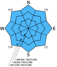
Aspect/Elevation ?
-
Likelihood ?CertainVery LikelyLikelyPossible
 Unlikely
 -
Size ?HistoricVery LargeLargeSmall

Avalanche concerns for today will remain few to none. With the warmer temperatures and higher freezing levels there is a slight possibility of loose wet slide activity in steeper, extreme terrain in areas below the freezing level. However, the shallow snowpack with many rocks protruding and the approaching storm bringing poor visibility will likely keep skiers and riders off of this terrain anyway. Widespread consolidation of the snowpack continued yesterday with the warm temperatures and additional settling of the snowpack. Any wind slabs near and above treeline in lee areas have bonded with underlying snow layers and are not a concern. The primary concern for backcountry skiers/riders/snowmobilers will continue to be shallow buried obstacles that could ruin one's season by tweaking a knee, bashing an A-arm, trashing equipment, etc. Keep your eyes open, and stay cautious!
Forecast Discussion
Heavy rains and strong winds have begun to move on shore early this morning already bringing urban flooding to coastal towns in Southern Oregon. A "high wind watch" has been issued for the higher elevations of Mt. Shasta for tonight into Thursday. The rain is just starting here in Mt. Shasta City, and the next few days are looking very wet. Up to 0.75 of an inch of water is expected today, with additional amounts tonight and tomorrow. The last couple of days have brought a warming trend raising snow levels up to approximately 8,500 to 9,000 feet. These warm temperatures will continue through this morning until a cooling trend begins late this afternoon into the evening. A group of storms is lined up across the Pacific promising a wet remainder of the week into the weekend with falling snow levels. Southerly winds, as mentioned above, will be high, especially above treeline.
THIS SEASON PRECIPITATION: Since October 1st (the wet season), we have received 4.73 inches of water, normal is 9.21 inches, putting us at 51% of normal. For the month of December, we have received 2.70 inches of water, normal is 1.85 putting us at 145% of normal. For the year of 2015 we've received 21.91 inches of water, normal is 37.21 inches putting us at 58% of normal.
Recent Observations
Recent observations on Mt. Shasta yesterday continue to point towards a strengthening snowpack with the snow line topping out around 8,500-9,000 ft. The consolidation and strengthening brought by warmer temps will allow the snowpack to handle the additional load of the snow fall promised by the line of storms approaching the area. The snowpack settled an additional 1-2 inches in the forecast area. No wet snow instabilities have been observed. The skiing conditions were fairly poor yesterday, but the snowmobiling was decent.
Visibility was good allowing recreation above treeline. That being said the "chocolate chips" created by rocks poking out of the still shallow snow limited the terrain available for snowmobiling above treeline. The heavy, wet, consolidating snow helped by keeping riders on the snow's surface. A well defined slab has been difficult to identify due to the uneven ground surface with rocks, down trees, and brush anchoring the snowpack. Wind is almost always a factor on Mt Shasta above treeline, scouring many areas. The presence of any small to medium wind slabs along ridge tops, bowls and in extreme terrain will continue to bond. Sensitivity of said slabs is unknown, so use cautious route finding, dig a pit, conduct a stability test!
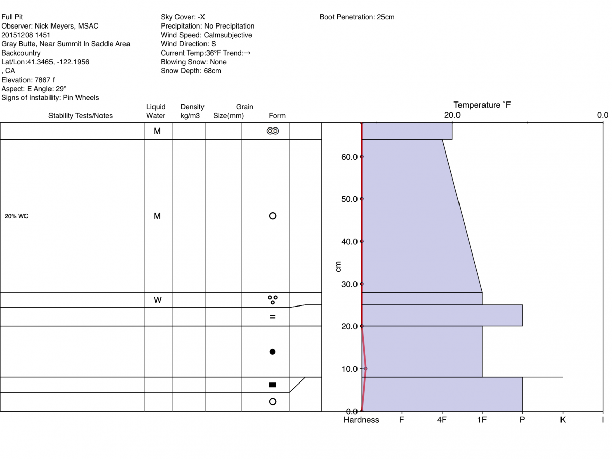
An approximately 1 cm thick ice crust on the surface of the snowpack was observed on southerly aspects yesterday in Old Ski Bowl. The snow underneath was quite saturated with melt water. A full pit profile was completed by Nick Meyers on Gray Butte, near the summit saddle area at 7800 ft. on an East aspect with a slope angle of 29 degrees. ECT tests had no results.
The Sand Flat cross country ski trails are snow covered and ready for your cross country skis. These are backcountry trails marked with blue diamonds on trees. Trails are not groomed. Enjoy!
Pilgrim Creek Snowmobile Park has 4-6 inches of snow at the parking area as of 12.4.15.
The Five Red Flags of Avalanche Danger any time of year include: 1) Recent/current avalanche activity 2) Whumpfing sounds or shooting cracks 3) Recent/current heavy snowfall 4) Strong winds transporting snow 5) Rapid warming or rain on snow.
Weather and Current Conditions
Weather Summary
Good Morning! In Mt Shasta City at 0500, we have a current temperature of 46 F with overcast skies.
MOUNTAIN WEATHER STATION INFORMATION (0500hrs):
On Mt Shasta (South Side) in the last 24 hours...
Old Ski Bowl - 7,600 feet, the current temperature is 31 degrees F. Snow on the ground totals 21 inches with no new snow and 2 inches settlement in the last 24 hours. Temperatures have ranged from 31 F to 40 F.
Gray Butte - 8,000 feet, the current temperature is 30 degrees F. Temperatures have ranged from 30 F to 36 F in the last 24 hours. Winds have averaged 19 mph with max gusts to 35 mph. Gray Butte Anemometer fixed!
Castle Lake and Mt Eddy (West side of Interstate-5)...
Castle Lake - 5,600 feet, the current temperature is 36 degrees F. Temperatures have ranged from 35 F to 42 F in the last 24 hours. Snow on the ground measures 9 inches with 2 inches settlement in the last 24 hrs.
Mt Eddy - 6,500 feet, the current temperature is 36 degrees F. Temperatures have ranged from 35 F to 44 F. Snow on the ground measures 27 inches with no new snow 1 inches settlement in the last 24 hours. Winds have averaged 2 mph and southeasterly in direction with a max gust to 4 mph, ESE.
Always check the weather before you attempt to climb Mt Shasta. Further, monitor the weather as you climb. Becoming caught on the mountain in any type of weather can compromise life and limb. Be prepared.
| 0600 temperature: | 33 |
| Max. temperature in the last 24 hours: | 40 |
| Average wind direction during the last 24 hours: | WNW |
| Average wind speed during the last 24 hours: | 19 mi/hr |
| Maximum wind gust in the last 24 hours: | 35 mi/hr |
| New snowfall in the last 24 hours: | 0 inches |
| Total snow depth: | 22 inches |
Two Day Mountain Weather Forecast
Produced in partnership with the Medford NWS
| For 7000 ft to 9000 ft | |||
|---|---|---|---|
|
Wednesday (4 a.m. to 10 p.m.) |
Wednesday Night (10 p.m. to 4 a.m.) |
Thursday (4 a.m. to 10 p.m.) |
|
| Weather | Rain, up to .73 of an inch of new precip., cloudy and windy | Rain before 10 pm, then rain and snow. New precip amounts around 1 inch of water, cloudy and windy | Snow with new precip amounts around 0.6 of an inch, breezy. |
| Temperature (°F) | 39 | 30 | 33 |
| Wind (mi/hr) | South/Southwest becoming West in afternoon 20-25 mph with gusts to 40+ mph | South 20-25 mph, increasing to 35-40 mph after midnight | South/Southwest 15-20 mph with gusts to 35 mph |
| Precipitation SWE / Snowfall (in) | / 0 | / 8-12 | / 3-5 |
| For 9000 ft to 11000 ft | |||
| Wednesday | Wednesday Night | Thursday | |
| Weather | Snow, could be heavy at times. Windy, wind chill values as low as zero. | Snow, could be heavy at times. Windy, wind chill values as low as -4. | Snow. Windy, wind chill values as low as -18. |
| Temperature (°F) | 30 | 28 | 17 |
| Wind (mi/hr) | West 55-60 mph with gusts to 70+ mph | Southwest 3-7 | Southwest 30-35 mph with higher gusts |
| Precipitation SWE / Snowfall (in) | / 3-7 | / 15-21 | / 5-9 |

