

You are here
Avalanche Advisory for 2015-12-10 07:01:46
- EXPIRED ON December 11, 2015 @ 7:01 amPublished on December 10, 2015 @ 7:01 am
- Issued by Jon Dove - Shasta-Trinity National Forest
Bottom Line
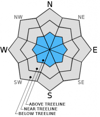
MODERATE avalanche danger exists above treeline due to storm slab and potential wind slab formation overnight.
LOW avalanche danger exists near and below treeline on all aspects. Avalanche danger will rise as temperatures drop and new snow accumulates. Early season snowpack conditions exist. Watch out for shallow buried objects!


Avalanche Problem 1: Storm Slab
-
Character ?

-
Aspect/Elevation ?
-
Likelihood ?CertainVery LikelyLikelyPossible
 Unlikely
 -
Size ?HistoricVery LargeLargeSmall

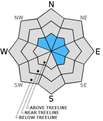
Last nights storm was fairly warm with snow levels hovering around 7,500 ft. bringing rain and snow mix to near treeline and rain below treeline. This only spells out continued bonding and solidification of a great base for the rest of our winter. Above treeline, however, the precip fell as snow. Based on recorded 24 hour precip amounts this could translate into 8-12 inches of new snow forming a storm slab over the old snow surface. The shallow snowpack still has plenty of rocks poking through to act as anchors for the snow, but those will soon be buried offering little assistance in adding stability. The avalanche danger for storm slabs will increase with added snow. Encountering significant storm slab formations will be unlikely as any travel above treeline will be limited today due to poor visibility.
Avalanche Problem 2: Wind Slab
-
Character ?

-
Aspect/Elevation ?
-
Likelihood ?CertainVery LikelyLikelyPossible
Unlikely
-
Size ?HistoricVery LargeLargeSmall
Strong southerly winds with last nights storm may have transported significant amounts of snow that fell above treeline on to SE-E-NE-N-NW aspects forming shallow wind slabs. The wet snow surface combined with warmer, wet snow that fell will encourage quick bonding. The wet snow combined with thin wind slab formation will make triggering wind slab avalanches unlikely. Travel over areas of wind slab formation will be limited due to poor visibility above treeline. Wind slabs are often dense, rounded, and hollow sounding.
Forecast Discussion
Early yesterday morning a storm brushed along to the north of our area with only a brief amount of rain fall locally leaving us with scattered clouds for the rest of the day. Light rain began around 7 pm yesterday evening with periods of moderate to heavy rain between 9 pm and 2 am. Snow levels hovered around 7,500 ft through the night. A high wind warning is in effect until 2 pm today, and a winter weather advisory is in effect from 4 pm today until 4 am on Friday above 4,000 ft. Today expect widespread rain and snow showers, mainly in the late afternoon to early evening, with temperatures falling through the day. Snow levels will drop to around 4,000 ft tonight into Friday, then rising to around 6,000-6,500 ft for the weekend. Friday only has the potential for less than a tenth of an inch of precipitation while the bulk of the weekends moisture arrives late Saturday into early Sunday. Things will remain wet as the jet continues to focus on the region.
THIS SEASON PRECIPITATION: Since October 1st (the wet season), we have received 5.35 inches of water, normal is 9.45 inches, putting us at 56% of normal. For the month of December, we have received 3.32 inches of water, normal is 2.09 putting us at 158% of normal. For the year of 2015 we've received 22.53 inches of water, normal is 37.45 inches putting us at 60% of normal.
Recent Observations
Observations made during a short tour on Mt. Shasta yesterday revealed a snowpack that continues to strengthen with partly sunny skies and warm temperatures. Due to the weather conditions snow crystals within the snowpack continued to decompose, rounding and bonding with one another. The consolidation and strengthening brought by warmer temps will allow the snowpack to handle the additional load of the snow fall promised by the set of storms approaching the area. The snowpack settled an additional 1-4 inches in the forecast area. No wet snow instabilities such as loose wet sluffs, or roller balls were observed. The skiing conditions were surprisingly OK near treeline yesterday as snow surface conditions remained soft, albeit a little heavy. A pit was dug on a westerly aspect, at about 7,800 ft revealing hard to discern layers of snow at different densities. A compression test was performed revealing a score of CTN (no fracture after 30 taps).
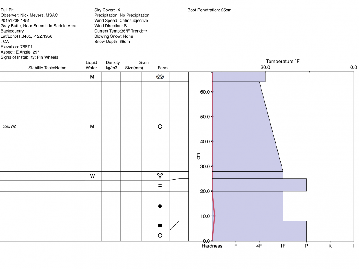
12-18-2015: A full pit profile was completed by Nick Meyers on Gray Butte, near the summit saddle area at 7800 ft. on an East aspect with a slope angle of 29 degrees. ECT tests had no results.
The Sand Flat cross country ski trails are snow covered and ready for your cross country skis. These are backcountry trails marked with blue diamonds on trees. Trails are not groomed. Enjoy!
Pilgrim Creek Snowmobile Park has 4-6 inches of snow at the parking area as of 12.4.15.
The Five Red Flags of Avalanche Danger any time of year include: 1) Recent/current avalanche activity 2) Whumpfing sounds or shooting cracks 3) Recent/current heavy snowfall 4) Strong winds transporting snow 5) Rapid warming or rain on snow.
Weather and Current Conditions
Weather Summary
Good Morning! In Mt Shasta City at 0500, we have a current temperature of 41 F with overcast skies with light rain.
MOUNTAIN WEATHER STATION INFORMATION (0500hrs):
On Mt Shasta (South Side) in the last 24 hours...
Old Ski Bowl - 7,600 feet, the current temperature is 28 degrees F. Snow on the ground totals 21 inches with a trace of new snow and 1 inch of settlement in the last 24 hours. Temperatures have ranged from 28 F to 34 F.
Gray Butte - 8,000 feet, the current temperature is 27 degrees F. Temperatures have ranged from 27 F to 33 F in the last 24 hours. Winds have averaged 18 mph with max gusts to 56 mph.
Castle Lake and Mt Eddy (West side of Interstate-5)...
Castle Lake - 5,600 feet, the current temperature is 32 degrees F. Temperatures have ranged from 32 F to 43 F in the last 24 hours. Snow on the ground measures 6 inches with 3 inches settlement in the last 24 hrs.
Mt Eddy - 6,500 feet, the current temperature is 29 degrees F. Temperatures have ranged from 29 F to 37 F. Snow on the ground measures 23 inches with no new snow and 4 inches settlement in the last 24 hours. Winds have averaged 2 mph and southerly in direction with a max gust to 21 mph, SW.
Always check the weather before you attempt to climb Mt Shasta. Further, monitor the weather as you climb. Becoming caught on the mountain in any type of weather can compromise life and limb. Be prepared.
| 0600 temperature: | 28 |
| Max. temperature in the last 24 hours: | 38 |
| Average wind direction during the last 24 hours: | WSW |
| Average wind speed during the last 24 hours: | 18 mi/hr |
| Maximum wind gust in the last 24 hours: | 56 mi/hr |
| New snowfall in the last 24 hours: | 1 inches |
| Total snow depth: | 21 inches |
Two Day Mountain Weather Forecast
Produced in partnership with the Medford NWS
| For 7000 ft to 9000 ft | |||
|---|---|---|---|
|
Thursday (4 a.m. to 10 p.m.) |
Thursday Night (10 p.m. to 4 a.m.) |
Friday (4 a.m. to 10 p.m.) |
|
| Weather | Snow showers. Temps falling to near 23 degrees by 5 pm. Breezy | Snow showers, mainly before 4 am. Breezy | Snow showers mainly after 10 am. |
| Temperature (°F) | 35 | 22 | 32 |
| Wind (mi/hr) | Southwest 20-25 mph with gusts to 40 mph | South 15-20 mph with higher gusts | Southwest 10-15 mph with gusts to 25 mph |
| Precipitation SWE / Snowfall (in) | / 3-5 | / 4-8 | / 2-4 |
| For 9000 ft to 11000 ft | |||
| Thursday | Thursday Night | Friday | |
| Weather | Snow showers, cloudy. Windy, wind chill values as low as -21. | Snow showers mainly before 4 am, could be heavy at times. Windy, wind chill values as low as -18. | Snow showers, mainly after 10 am. Windy, wind chill values as low as -16. |
| Temperature (°F) | 15 | 13 | 16 |
| Wind (mi/hr) | West 50-55 mph with gusts to 70+ mph | Southwest 6-10 | West 30-35 mph with higher gusts |
| Precipitation SWE / Snowfall (in) | / 6-10 | / 8-12 | / 4-8 |

