

You are here
Avalanche Advisory for 2015-12-11 07:00:18
- EXPIRED ON December 12, 2015 @ 7:00 amPublished on December 11, 2015 @ 7:00 am
- Issued by Jon Dove - Shasta-Trinity National Forest
Bottom Line
LOW avalanche danger exists for all elevations and aspects. Avalanche danger will rise as significant amounts of new snow accumulate. Early season snowpack conditions exist. Watch out for shallow buried objects!


Avalanche Problem 1: Wind Slab
-
Character ?

-
Aspect/Elevation ?
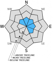
-
Likelihood ?CertainVery LikelyLikelyPossible
 Unlikely
 -
Size ?HistoricVery LargeLargeSmall

Small, shallow wind slabs were identified in isolated leeward aspects above treeline yesterday. The wet snow combined with the thin nature of the wind slabs has resulted in relatively quick bonding of the snow crystals over the past 24+ hours. This means triggering one of these wind slabs is unlikely. If one of these wind slabs were to be released the slide would be small in size, however, it doesn't take much sliding snow to push one into undesirable terrain. Caution should be taken if traveling on any leeward SE-E-NE-N-NW aspect. At near and below treeline locations wind slabs are not a concern.
Forecast Discussion
The last two days have called for significant precipitation amounts. While we have received some of that precip, it has arrived during the night time hours leaving yesterday's daytime relatively dry. Precip amounts have been slightly less than what was forecast for, as well, with the stronger front pushing to the north and south of us (the Tahoe area recieved 12-18 inches of new snow). Temperatures began to drop during the day yesterday as heat was able to escape through broken clouds. The affects of this cooling and its impact on the snow are discussed below. The next storm is still forecast to begin bringing rain in the valleys and snow at higher elevations during the day Saturday and into Sunday. Precipitation amounts will be the strongest the second half of Saturday into the evening and early Sunday morning. Snow levels will begin at 3,500-4,000 ft on Friday rising through the day Saturday to peak at 6,500-7,000 ft before beginning to lower again on Sunday. Winds will be predominantly WNW through Saturday, shift to WSW on Sunday ranging from 20-40 mph above 10,000 ft.
THIS SEASON PRECIPITATION: Since October 1st (the wet season), we have received 6.00 inches of water, normal is 9.69 inches, putting us at 61% of normal. For the month of December, we have received 3.97 inches of water, normal is 2.33 putting us at 170% of normal. For the year of 2015 we've received 23.18 inches of water, normal is 37.69 inches putting us at 61% of normal.
Recent Observations
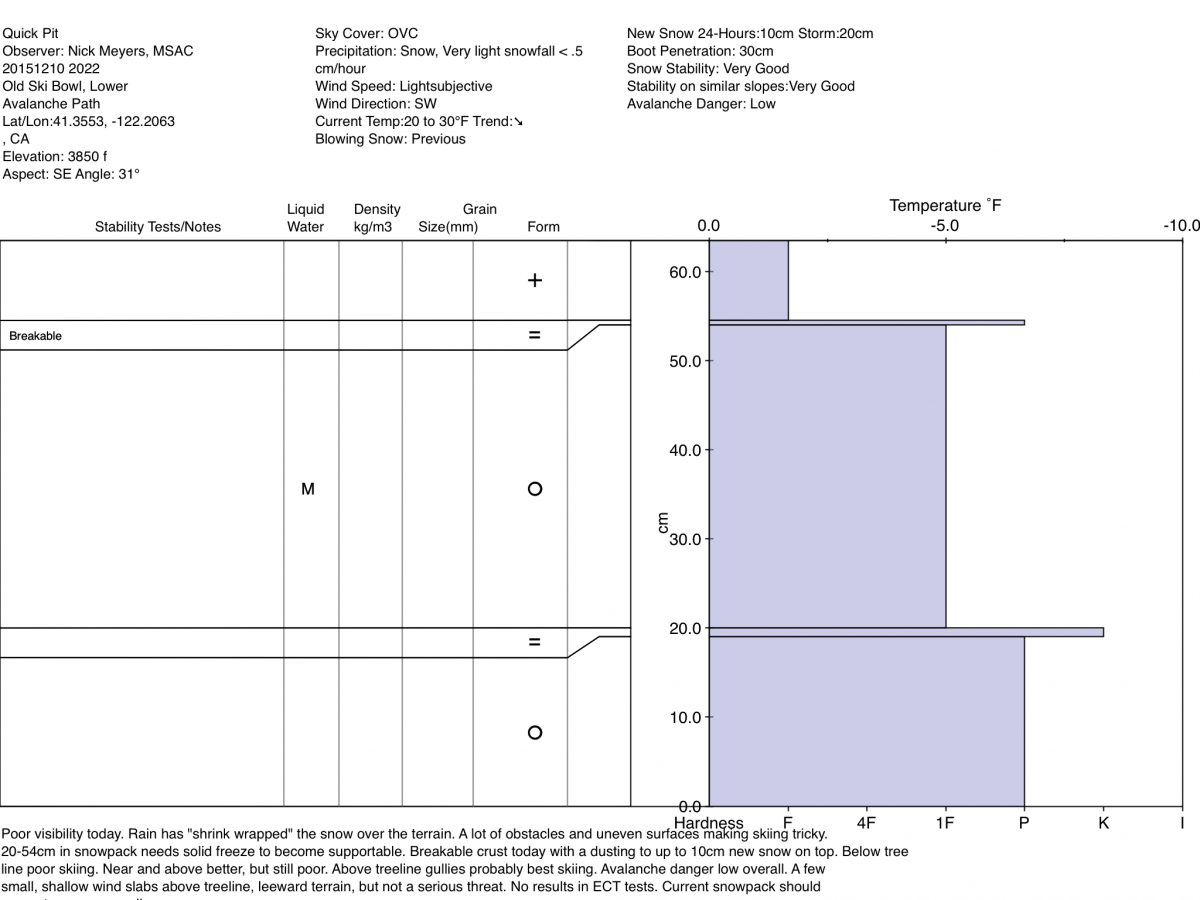
Observations reported from those who ventured up on Mt Shasta yesterday revealed some challenging snow and ski conditions. Above treeline, 5-10 cm of new snow was lying on top of a breakable crust. The best skiing/riding was found in gully bottoms in above treeline areas, but in general ski conditions were poor. An analysis of the snowpack revealed no real storm slab formation, however, small, shallow wind slabs were found in isolated areas on leeward aspects. A "quick pit" was dug by Nick Meyers (on his days off!) displaying a "right side up" cross section of the snow. The pit was located in lower Old Ski Bowl on a SE aspect with a slope angle of 31 degrees. The pit profile shows a hard frozen base approximately 18 cm thick covered by a thin ice layer, then slightly less dense (1 finger pen.) snow covered by that breakable crust. A topping of 5-10 cm of new snow covers the breakable crust. Hopefully the night's cold temperatures was enough of a solid freeze to make the snowpack supportable.
The Sand Flat cross country ski trails are snow covered and ready for your cross country skis. These are backcountry trails marked with blue diamonds on trees. Trails are not groomed. Enjoy!
The Five Red Flags of Avalanche Danger any time of year include: 1) Recent/current avalanche activity 2) Whumpfing sounds or shooting cracks 3) Recent/current heavy snowfall 4) Strong winds transporting snow 5) Rapid warming or rain on snow.
Weather and Current Conditions
Weather Summary
Good Morning! In Mt Shasta City at 0500, we have a current temperature of 35 F with overcast skies.
MOUNTAIN WEATHER STATION INFORMATION (0500hrs):
On Mt Shasta (South Side) in the last 24 hours...
Old Ski Bowl - 7,600 feet, the current temperature is 20 degrees F. Snow on the ground totals 24 inches with a 3 inches of new snow in the last 24 hours. Temperatures have ranged from 20 F to 26 F.
Gray Butte - 8,000 feet, the current temperature is 19 degrees F. Temperatures have ranged from 19 F to 27 F in the last 24 hours. Winds have averaged 26 mph with max gusts to 78 mph. Gray Butte wind gauge (anemometer) is not currently functioning.
Mt Eddy (West side of Interstate-5)...
Castle Lake - 5,600 feet, the current temperature is 24 degrees F. Temperatures have ranged from 24 F to 31 F in the last 24 hours. Snow on the ground measures 7 inches with 1 inch new snow in the last 24 hrs.
Mt Eddy - 6,500 feet, the current temperature is 23 degrees F. Temperatures have ranged from 22 F to 29 F. Snow on the ground measures 24 inches with 1 inch new snow and in the last 24 hours. Winds have averaged 2 mph and southerly in direction with a max gust to 14 mph, SSE.
Always check the weather before you attempt to climb Mt Shasta. Further, monitor the weather as you climb. Becoming caught on the mountain in any type of weather can compromise life and limb. Be prepared.
| 0600 temperature: | 23 |
| Max. temperature in the last 24 hours: | 31 |
| Average wind direction during the last 24 hours: | Westerly |
| Average wind speed during the last 24 hours: | 26 mi/hr |
| Maximum wind gust in the last 24 hours: | 78 mi/hr |
| New snowfall in the last 24 hours: | 3 inches |
| Total snow depth: | 24 inches |
Two Day Mountain Weather Forecast
Produced in partnership with the Medford NWS
| For 7000 ft to 9000 ft | |||
|---|---|---|---|
|
Friday (4 a.m. to 10 p.m.) |
Friday Night (10 p.m. to 4 a.m.) |
Saturday (4 a.m. to 10 p.m.) |
|
| Weather | Cloudy, Snow. Chance of precip 100% | Cloudy with snow showers likely, mainly before 10 pm. Chance of precip 70% | Cloudy, Snow. Chance of precip 90% |
| Temperature (°F) | 30 | 24 | 31 |
| Wind (mi/hr) | Southwest 10-15 mph with gusts to 25 mph | West 15-20 mph with gusts to 30 mph | West/Northwest, becoming Southwest in the a.m. 10-15 mph with gusts to 20 mph |
| Precipitation SWE / Snowfall (in) | / 2-4 | / 1-2 | / 3-5 |
| For 9000 ft to 11000 ft | |||
| Friday | Friday Night | Saturday | |
| Weather | Snow showers, cloudy. Windy, wind chill values as low as -13. Chance of precip 100% | Snow showers mainly before 4 am. Windy, wind chill values as low as -14. Chance of precip 80% | Snow. Windy, wind chill values as low as -16. Chance of precip 90% |
| Temperature (°F) | 16 | 13 | 27 |
| Wind (mi/hr) | West 25-30 mph with gusts to 60 mph | Northwest 3-5 | Northwest 40-50 mph then decreasing in the a.m. to 20-25 mph with gusts to 70 mph |
| Precipitation SWE / Snowfall (in) | / 3-5 | / 1-3 | / 4-8 |

