

You are here
Avalanche Advisory for 2015-12-13 07:01:07
- EXPIRED ON December 14, 2015 @ 7:01 amPublished on December 13, 2015 @ 7:01 am
- Issued by Nick Meyers - Shasta-Trinity National Forest
Bottom Line
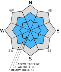
Near and above treeline, the avalanche danger is MODERATE for wind and storm slab avalanches, all aspects. Complex, steep terrain, wind loaded couloirs, open bowls and slopes lacking ground anchors will host the greatest danger for triggering small to medium size wind and storm slabs.
Below treeline, the avalanche danger is LOW. Continue to watch out for shallow buried objects.


Avalanche Problem 1: Wind Slab
-
Character ?

-
Aspect/Elevation ?

-
Likelihood ?CertainVery LikelyLikelyPossible
 Unlikely
 -
Size ?HistoricVery LargeLargeSmall

MODERATE danger exists for wind slab avalanches near and above treeline. New snow accumulation thus far has left 3-5 inches at the Old Ski Bowl weather station (treeline, 8,000 feet) and snowing as we speak. Another 6-12 inches of snow is expected today. The almost always present wind on Mt Shasta has been moving snow around and wind slabs will grow in size as the storm wears on. For this storm, wind began out of the N-NW, shifted to S-SW, and will return back to N-NW this afternoon. This means that many, if not all aspects could host small to medium size wind slabs due to local orograhpics and cross loading. If you find yourself in steep and wind drifted terrain, be on the lookout for signs of instability.
Avalanche Problem 2: Storm Slab
-
Character ?

-
Aspect/Elevation ?
-
Likelihood ?CertainVery LikelyLikelyPossible
Unlikely
-
Size ?HistoricVery LargeLargeSmall
MODERATE danger exists today for storm slabs, all aspects, near and above treeline terrain in steep, open bowls lacking ground anchors. Slabs up to 1.5 feet deep are possible and could be sensitive to trigger due to rapid snow accumulation from current storm in progress.
Forecast Discussion
We are in the thick of our winter storm this morning as heavy rain falls in town and the mountain receives snow! As predicted, snow levels are higher currently, however will lower from near 5,500 feet to 2,000-3,000 feet. The Gray Butte anemometer (wind sensor) has been giving us trouble and we don't have any wind information from on the mountain this morning, but based on looking at the models, we safely assume winds are blowing pretty darn good near and above treeline. South/southwest winds are starting us off this morning and will shift to northwest in the afternoon and decrease in velocity. Precipitation will taper throughout the day. By the end of the storm, near 1.25 inches of water is expected, which could give us new snow totals of 8-15 inches in some areas. This storm will taper over the next few days and bring drier weather by Tuesday. "Drier weather" is not music to the ears for snow people, but rest easy, it appears another storm could give us more winter action late next week/weekend.
THIS SEASON PRECIPITATION: Since October 1st (the wet season), we have received 6.12 inches of water, normal is 10.18 inches, putting us at 60% of normal. For the month of December, we have received 4.09 inches of water, normal is 2.82 putting us at 145% of normal. For the year of 2015 we've received 23.30 inches of water, normal is 38.18 inches putting us at 61% of normal.
Recent Observations
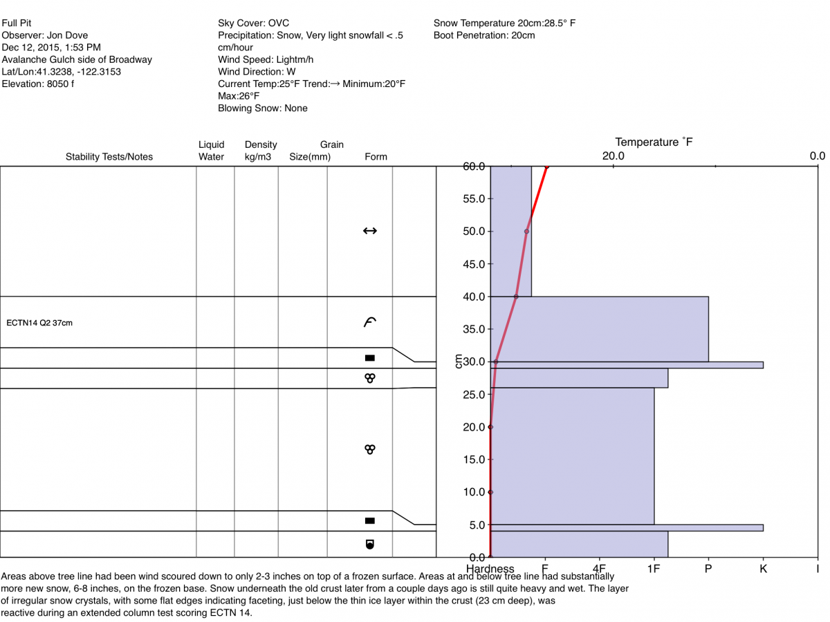
Yesterday, observations from the West side of Broadway near treeline still revealed a strong temperature gradient above the crust, in the top 30cm of the snowpack with some faceting observed. Near and above treeline, signs of instability have been few to none over the past few days. That said, data still indicates a temperature gradient is still present and weak layer development possible in the upper portion of the snowpack. How reactive this weak layer is to propagation with the added weight of new snow on top is uncertain. It's a definite possibility that a person or snowmobile in the right spot on the right slope could trigger said layer. Slopes above treeline with smooth ground cover and less anchors will be most suceptible to weak layer fracture and propagation of newly formed wind and storm slabs.
Terrain above treeline was mostly scoured yesterday with only 5-7cm snow on top. Near and just below treeline had better fresh snow accumulation, 15-20cm, due to less wind. Concern should lie for areas near and above treeline, in extreme terrain or below ridgelines and in open bowls where wind has not scoured the snow to the crust layer, and where new snow has formed wind and storm slabs. Steep terrain, wind-loaded couloirs, unsupported slopes, cliffs and heavily wind loaded areas will host the more fragile conditions.
The Sand Flat cross country ski trails are snow covered and ready for your cross country skis. These are backcountry trails marked with blue diamonds on trees. Trails are not groomed. Enjoy!
The Five Red Flags of Avalanche Danger any time of year include: 1) Recent/current avalanche activity 2) Whumpfing sounds or shooting cracks 3) Recent/current heavy snowfall 4) Strong winds transporting snow 5) Rapid warming or rain on snow.
Weather and Current Conditions
Weather Summary
Good Morning! In Mt Shasta City at 0500, we have a current temperature of 39 F with rain heavy at times and windy.
MOUNTAIN WEATHER STATION INFORMATION (0500hrs):
On Mt Shasta (South Side) in the last 24 hours...
Old Ski Bowl - 7,600 feet, the current temperature is 23 degrees F. Snow on the ground totals 29 inches with 3-5 inches of new snow in the last 24 hours. Temperatures have ranged from 19 F to 23 F.
Gray Butte - 8,000 feet, the current temperature is 22 degrees F. Temperatures have ranged from 17 F to 21 F in the last 24 hours. The Gray Butte Anemometer is down again. Working on troubleshooting this problem. Winds are likely west/southwest, 25 - 35 mph with gusts to 50 - 60 mph.
Mt Eddy (West side of Interstate-5)...
Castle Lake - 5,600 feet, the current temperature is 29 degrees F. Temperatures have ranged from 23 F to 29 F in the last 24 hours. Snow on the ground measures 10 inches with 4 inches new snow in the last 24 hrs.
Mt Eddy - 6,500 feet, the current temperature is 28 degrees F. Temperatures have ranged from 18 F to 34 F. Snow on the ground measures 26 inches with 3-5 inches new snow in the last 24 hours. Winds have averaged 2 mph and southeast in direction with a max gust to 20 mph, ESE.
Always check the weather before you attempt to climb Mt Shasta. Further, monitor the weather as you climb. Becoming caught on the mountain in any type of weather can compromise life and limb. Be prepared.
| 0600 temperature: | 25 |
| Max. temperature in the last 24 hours: | 27 |
| Average wind direction during the last 24 hours: | Southwest |
| Average wind speed during the last 24 hours: | 5-15 mi/hr |
| Maximum wind gust in the last 24 hours: | n/a mi/hr |
| New snowfall in the last 24 hours: | trace inches |
| Total snow depth: | 29 inches |
Two Day Mountain Weather Forecast
Produced in partnership with the Medford NWS
| For 7000 ft to 9000 ft | |||
|---|---|---|---|
|
Sunday (4 a.m. to 10 p.m.) |
Sunday Night (10 p.m. to 4 a.m.) |
Monday (4 a.m. to 10 p.m.) |
|
| Weather | Snow before 1pm, then scattered snow showers. Snow heavy at times | Some lingering snow showers | Chance of snow showers, partly sunny |
| Temperature (°F) | 29 | 17 | 22 |
| Wind (mi/hr) | South/southwest becoming northwest 15-20 mph | West/Northwest 10-15 mph | Northwest 10-15 mph |
| Precipitation SWE / Snowfall (in) | / 6-12 | / 1-2 | / 0-1 |
| For 9000 ft to 11000 ft | |||
| Sunday | Sunday Night | Monday | |
| Weather | Snow, mainly before 10am, heavy at times, snow showers after 10am | Lingering snow showers, mostly cloudy | Perhaps a snow shower, partly sunny, chilly |
| Temperature (°F) | 13 | 2 | 7 |
| Wind (mi/hr) | Southwest becoming northwest 40-50 mph | North/northwest 6-12 | Northwest 20-30 mph |
| Precipitation SWE / Snowfall (in) | / 6-12 | / 2-4 | / 0-1 |

