

You are here
Avalanche Advisory for 2015-12-14 06:59:28
- EXPIRED ON December 15, 2015 @ 6:59 amPublished on December 14, 2015 @ 6:59 am
- Issued by Nick Meyers - Shasta-Trinity National Forest
Bottom Line
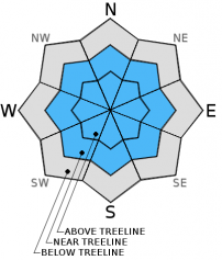
CONSIDERABLE avalanche danger exists near and above treeline today on slopes steeper than 32 degrees, all aspects. Near crust facets forming a persistent weak layer, 40-50cm deep in the snowpack, will be todays main avalanche problem.
Wind slabs above treeline will also be a concern. Limited observations leave significant uncertainty of wind slab sensitivity.
Below treeline, the avalanche danger is MODERATE.


Avalanche Problem 1: Persistent Slab
-
Character ?

-
Aspect/Elevation ?
-
Likelihood ?CertainVery LikelyLikelyPossible
 Unlikely
 -
Size ?HistoricVery LargeLargeSmall

In some areas, the existing snowpack is handling the added weight of the new snow well. Other areas, it's not. Persistent weak layers in the form of near crust facets, first observed on December 11th, have been observed 40-50cm deep in the snowpack. Rounded facets remain loose and weak. The presence or absence of the avalanche problem will vary widely from one location to another due to depth of snow, aspect and elevation, and ground anchors/protrusions. We've included all aspects, however suspect areas are W-SW-S-SE-E facing aspects, mostly below and near treeline and isolated potential above treeline. Failure of facets have the potential to propagate far and wide due to widespread rain crust. Open areas where uniform rain crust prevails and ground anchors minimal will be the best place for large scale failure.
Collapsing and whumpfing on low angle terrain was observed yesterday along with very easy failures and full propagation within ECT tests. Use your shovel and dig a pit to seek out information indicating the presence or absence of the faceted weak layer in specific areas.
Continued wind loading or, a skier or rider on this persistent weak layer could tip the stress vs strength scale. It seems to be right on the verge...
Avalanche Problem 2: Wind Slab
-
Character ?

-
Aspect/Elevation ?

-
Likelihood ?CertainVery LikelyLikelyPossible
Unlikely
-
Size ?HistoricVery LargeLargeSmall
Snow is on the ground and has been readily available for transport. Wind slabs will continue to build in size and distribution. Strong winds can deposit wind slabs far down the slope below traditional avalanche start zones as well as creating wind slabs below treeline. Cornice formations, pillows of drifted snow below ridgelines, piles of drifted snow in lee areas behind rocks and trees or entering areas of suddently dense snow are all indicators of wind slabs in the area! Avoid these areas by traveling in areas less than 30 degrees in slope angle without steeper terrain above.
We've seen the full spectrum of wind loading on all aspects. That said, south winds started our storm, switched to west yesterday and continued to swing northerly late yesterday and today. Local orographics allow many aspects to wind load on Mt Shasta. Significant uncertainty exists for wind slab sensitivity to triggering due to lack of upper elevation observations. Keep your situational awareness up no matter where you are today.
Forecast Discussion
While the recent storms over the past week gave us a few inches here and there, they were seemingly over forecasted and left many wondering, "What the heck!". We queued up for the good looking storm that swept over Mt Shasta beginning on December 12th and as the day wore on and not much happened. "Not again", I thought. Yesterday, I woke up and came into the office, checked the Old Ski Bowl weather station and saw only about 4-6 inches of new snow recorded. "Well, better than nothing..." I murmured. And then the boots hit the ground and what a pleasant surprise to find 1 to 1.5 feet of new snow spread across the landscape. Elevations 6,500 feet and above did quite well with new snow totals and our winter snowpack continues to smooth out rocks, trees and all other objects of potential injury.
We are going to see the weather clear today and tomorrow will likely be bluebird. Northerly winds will blow for most of the week, blowing snow around and keeping wind chill factors down in the negatives fahrenheit. In my fully charged crystal ball, the next best storm system looks to arrive this next weekend! Keep it reeling mother nature!
THIS SEASON PRECIPITATION: Since October 1st (the wet season), we have received 7.16 inches of water, normal is 10.43 inches, putting us at 68% of normal. For the month of December, we have received 5.13 inches of water, normal is 3.07 putting us at 167% of normal. For the year of 2015 we've received 24.34 inches of water, normal is 38.43 inches putting us at 63% of normal.
Recent Observations
While the Old Ski Bowl weather station only recorded less than a foot of new snow for the latest storm, 1 to 1.5 feet of new snow fell over the past 48 hours. Winds began out of the SSW, switched to W yesterday and finally swung NNW late yesterday and this morning. Average wind speeds of 20-30 mph with gusts 50-60 mph have been recorded.
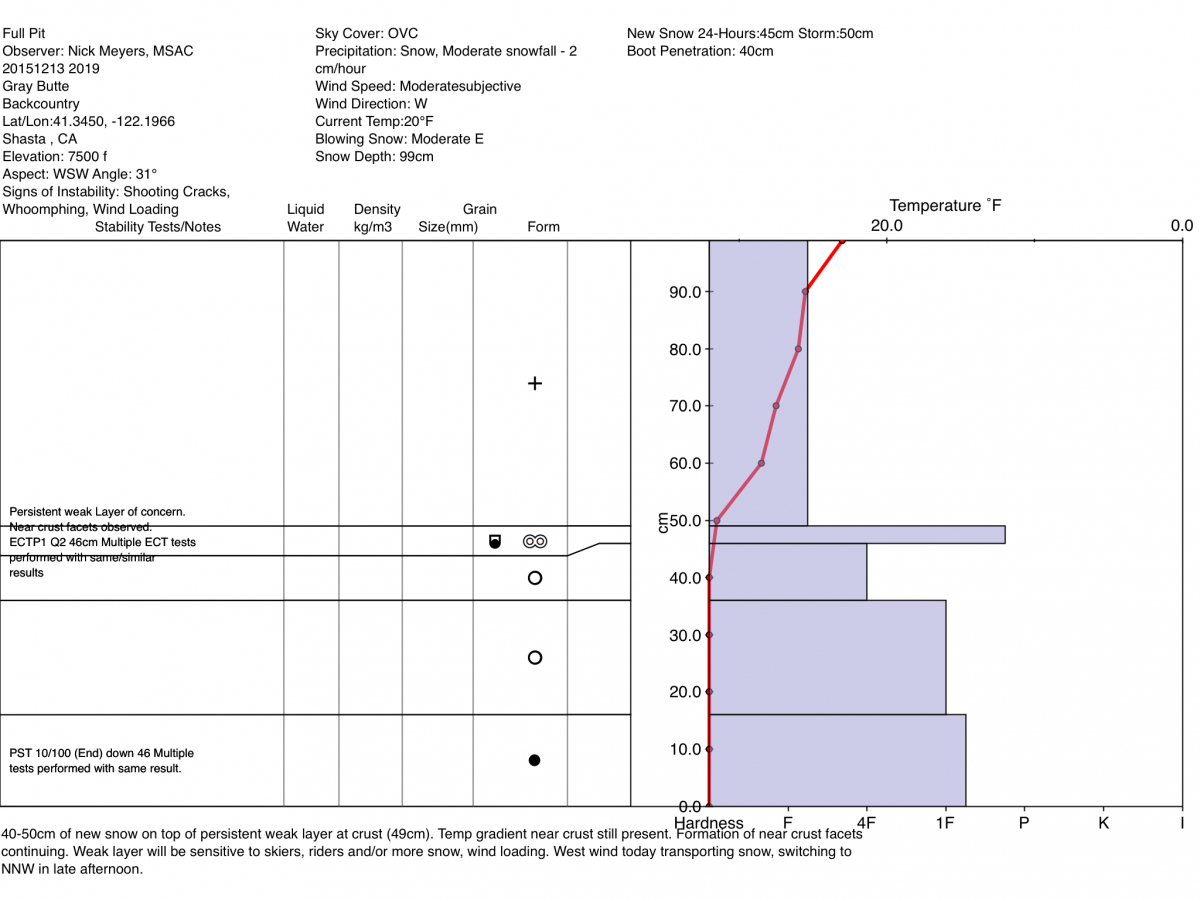
The weak layer mentioned in past days forecasts has persisted and yesterday we were able to get very easy failures within stability tests. Its been so long since we've had any sort of action like this, we made sure to conduct numerous tests over the entire westerly aspect of Gray Butte to verify what we were seeing! All ECT tests gave us full propagation with 1 to 5 taps from the wrist. Propagation saw tests resulted in many PST 10/100 (End) on the weak layer. Further, reports from local skiers on Green Butte Ridge area near treeline reported whoomfing and shooting cracks. The storm cleared enough late in the day to provide some visibility and no natural or human triggered avalanches were reported or observed. This leads me to believe that the snowpack stress versus strength scale is dangerously close to tipping. Our tests were conducted on a westerly aspect, various locations, 7,400 feet to 7,700 feet, 30-35 degrees. The persistent weak layer has also been noted on W-SW-S-SE-E aspects in the past few days.
The persistent weak layer of concern lies 40-50cm deep in the snowpack. From the surface of the snow, you'll find it at the first hard crust encountered in the snowpack. It's near this crust, both above and below, that easy failures with full propagation were initiated on facet layers. A strong temperature gradient was still observed and facets moderately developed. Continued cold temperatures are expected to preserve the persistent weak layer and further facet growth. Avalanche conditions will be touchy for the near future. Added stress from wind loading, a skier or snowmobile most certainly could tip the scale, triggering an avalanche.
The exact location and distributing of said weak layer is naturally, variable. Over the past few days, it seems like areas of most concern lie in the 7,500 foot to 8,500 foot levels on W-SW-S-SE-E aspects. Observations above 9,000 feet on the mountain are limited due to poor visibilty. Brief forays to just shy of 9,000 feet have shown the old snow surface to be bullet proof and snow bonding to the old snow/ice layer decent. Wind affect on the snow was noted and wind slabs 1-3 feet thick prevalent. Again, limited information and observations leave some uncertainty for upper elevation avalanche danger. Potentially sensitve wind slabs on steep slopes are to be treaded lightly on.
VIDEOS of ECT tests performed yesterday:
The Sand Flat cross country ski trails are snow covered and ready for your cross country skis. These are backcountry trails marked with blue diamonds on trees. Trails are not groomed. Enjoy!
The Five Red Flags of Avalanche Danger any time of year include: 1) Recent/current avalanche activity 2) Whumpfing sounds or shooting cracks 3) Recent/current heavy snowfall 4) Strong winds transporting snow 5) Rapid warming or rain on snow.
Weather and Current Conditions
Weather Summary
Good Morning! In Mt Shasta City at 0500, we have a current temperature of 32 F, light snow flurries and windy.
MOUNTAIN WEATHER STATION INFORMATION (0500hrs):
On Mt Shasta (South Side) in the last 24 hours...
Old Ski Bowl - 7,600 feet, the current temperature is 16 degrees F. Snow on the ground totals 37 inches with 6 inches of new snow in the last 24 hours measured at the weather station. However, 1-1.5 feet of new snow over the last 48 hours has been observed in the backcountry near treeline with 1-3 inches settlement. Temperatures have ranged from 15 F to 25 F.
Gray Butte - 8,000 feet, the current temperature is 13 degrees F. Temperatures have ranged from 13 F to 24 F in the last 24 hours. Winds have kicked up out of the NNW, averaging 30-40 mph and gusting to 64 mph.
Mt Eddy Range (West side of Interstate-5)...
Castle Lake - 5,600 feet, the current temperature is 19 degrees F. Temperatures have ranged from 19 F to 29 F in the last 24 hours. Snow on the ground measures 18 inches with 7 inches new snow. Storm total is about 10 inches with 1-3 inches settlement.
Mt Eddy - 6,500 feet, the current temperature is 17 degrees F. Temperatures have ranged from 17 F to 28 F. Snow on the ground measures 36 inches with 3-5 inches new snow in the last 24 hours. Winds have averaged 3 mph and SSE in direction with a max gust to 15 mph, SSE.
Always check the weather before you attempt to climb Mt Shasta. Further, monitor the weather as you climb. Becoming caught on the mountain in any type of weather can compromise life and limb. Be prepared.
| 0600 temperature: | 20 |
| Max. temperature in the last 24 hours: | 30 |
| Average wind direction during the last 24 hours: | NNW |
| Average wind speed during the last 24 hours: | 30 @ Gray Butte mi/hr |
| Maximum wind gust in the last 24 hours: | 64 @ Gray Butte mi/hr |
| New snowfall in the last 24 hours: | 5-7 at Old Ski Bowl inches |
| Total snow depth: | 37 inches |
Two Day Mountain Weather Forecast
Produced in partnership with the Medford NWS
| For 7000 ft to 9000 ft | |||
|---|---|---|---|
|
Monday (4 a.m. to 10 p.m.) |
Monday Night (10 p.m. to 4 a.m.) |
Tuesday (4 a.m. to 10 p.m.) |
|
| Weather | Scattered snow showers, partly cloudy, breezy | Partly cloudy, clearing | Mostly sunny, breezy |
| Temperature (°F) | 22 | 16 | 29 |
| Wind (mi/hr) | NNW 10-15 mph | NNW 10-15 mph | NNW 10-15 mph |
| Precipitation SWE / Snowfall (in) | / 1-2 | / 0-.5 | / 0 |
| For 9000 ft to 11000 ft | |||
| Monday | Monday Night | Tuesday | |
| Weather | Scattered snow showers, partly cloudy | Partly cloudy, clearing, cold | Mostly sunny, windy, cold |
| Temperature (°F) | 7 | 7 | 18 |
| Wind (mi/hr) | NNW 30-40 G-50 | NNW 1-3 | NNW 20-30 mph G-40 |
| Precipitation SWE / Snowfall (in) | / 1-3 | / 0-.5 | / 0 |

