

You are here
Avalanche Advisory for 2015-12-16 07:03:18
- EXPIRED ON December 17, 2015 @ 7:03 amPublished on December 16, 2015 @ 7:03 am
- Issued by Jon Dove - Shasta-Trinity National Forest
Bottom Line
MODERATE avalanche danger exists near and above treeline. Pockets of CONSIDERABLE danger may be found on uniform, open W-SW-S-SE-E-NE facing slopes steeper than 30 degrees, 7,500 to 8,500 feet. Near crust facets forming a persistent weak layer, 40-50cm deep in the snowpack, warrants continued concern.
Wind slabs above treeline are also a concern with continued strong winds above treeline loading NE-E-SE-S-SW slopes. Limited upper elevation observations leave uncertainty of wind slab sensitivity.
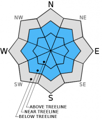
Below treeline, the avalanche danger is LOW


Avalanche Problem 1: Persistent Slab
-
Character ?

-
Aspect/Elevation ?
-
Likelihood ?CertainVery LikelyLikelyPossible
 Unlikely
 -
Size ?HistoricVery LargeLargeSmall

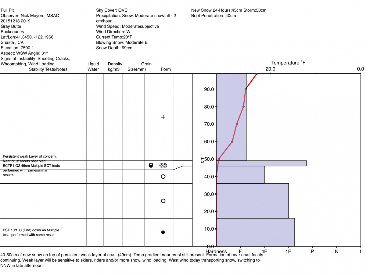
The obvious sensitivity of the persistent weak layer displayed by stability test results from December 13th (see videos) has resulted in a nervous tension among backcountry skiers/riders/snowshoers as it is an avalanche problem that is not often an issue with our maritime snowpack. This caution is warranted as the sensitivity to added weight and disturbance to the snowpack in areas where the right combination of factors exist could result in an avalanche. That being said, the fact that no natural or human triggered avalanches have occurred is puzzling. It would seem that with the results of our many tests a couple of days ago, the forecast area would see some avalanche activity. That has not been the case. This lack of evidence of this "sensitive" persistent weak layer is perhaps the result of our still shallow snowpack. The weak layer bed surface is not uniform and planar due to many ground protrusions still poking up into the snowpack disrupting uniform distribution. So, while yes a small 30 by 90 cm block will fracture and propagate, a full slope will not propagate due to rocks, stumps and down trees that are creating an uneven bed surface where the old rain crust in question exists.
Despite lack of any observations from yesterday, it should be noted that the persistent weak layer avalanche problem has not past, and may still be present on the aspects listed above in the 7,500-8,500 ft. elevations near treeline. We do believe the persistent slab problem still remains an issue, especially with continued cold temperatures. While it remains unlikely to trigger an avalanche on this layer if a user could find the right combination of weak layer with slab on top, it remains possible. There is hope on the horizon that the faceting that is occurring to the snow crystals around the crust layer 40-50 cm deep will begin to heal with warming temperatures on Thursday. Hopefully the facet growth will cease and the snow crystals will begin to round and bond with some melting influenced by warmer temps. The presence or absence of the avalanche problem will vary widely from one location to another due to depth of snow, aspect and elevation, and ground anchors/protrusions. The added weight of additional loading from wind slab development, a skier or rider, or snowmobile on this persistent weak layer could be enough to tip the stress vs strength scale where all ingredients for an avalanche come together perfectly. Be observant, be cautious, and travel accordingly.
The geographic location of this persistent weak layer has been difficult to track. For today, continue to avoid wide open, smooth and planar looking slopes just below, near and slightly above treeline in the 7,500 to 8,500 ft. elevation areas. The persistent weak layer has been found on NW-W-SW-S-SE facing slopes in this elevation band. In some areas the persistent weak layer is better developed than others. Unfortunately, we cannot nail this weak layer down perfectly. It is your responsibility to get your shovel out, dig a pit and identify the presence or absence of the weak layer. Conduct a few stability tests before considering skiing or riding on suspect slopes!
Avalanche Problem 2: Wind Slab
-
Character ?

-
Aspect/Elevation ?

-
Likelihood ?CertainVery LikelyLikelyPossible
Unlikely
-
Size ?HistoricVery LargeLargeSmall
Recent light density snow has been readily available for wind transport. Strong Northerly winds ruled Mt. Shasta yesterday continuing to build wind slabs in size and spatial distribution. Strong winds can deposit wind slabs far down the slope below traditional avalanche start zones as well as creating wind slabs below treeline. Avoid these areas by traveling in areas less than 30 degrees in slope angle without steeper terrain above. Even on scoured, windward aspects small wind slabs can develop. We've seen the full spectrum of wind loading on all aspects. Local orographics allow non-typical aspects to wind load on Mt Shasta. Over the course of the past week, we've had wind from all directions though the highest wind speeds have been blowing from the north/northwest. Uncertainty exists for wind slab sensitivity to triggering due to lack of upper elevation observations. Watch out for near and above treeline terrain near/below ridgetops, on the leeward side of rocks and tree outcrops, round/hollow sounding snow pillows, shooting cracks, narrow couloirs and extreme terrain.
Forecast Discussion
A warm frontal boundary will begin moving through the region late today into early Thursday ushering in unsettled weather over the next few days. Snow levels will rise to nearly 7,000 ft. late Thursday morning. Snow could fall at elevations above 4,000 ft. initially, but will begin to rise, bringing rain up to 7,000 ft before significant snow accumulation occurs. Temperatures will begin to cool again on Friday through Saturday this coming weekend pushing snow levels down to close to 2,000 ft. Precipitation totals will not be astounding for Mt Shasta, but we will still be getting a few inches here and there as the storms move through. There is a slight chance of freezing rain for Mt. Shasta City early Thursday morning. This could make roads slick, so drivers should use caution.
THIS SEASON PRECIPITATION: Since October 1st (the wet season), we have received 7.17 inches of water, normal is 10.94 inches, putting us at 65% of normal. For the month of December, we have received 5.14 inches of water, normal is 3.58 putting us at 143% of normal. For the year of 2015 we've received 24.35 inches of water, normal is 38.64 inches putting us at 62% of normal.
Recent Observations
We did not make, or receive, any observations from the field yesterday making judgment on any further changes to the snow pack difficult. The persistent weak layer that has been observed on W-SW-S-SE-E-NE aspects at between 7,500-8,500 ft. may have not been able to heal itself quite yet as temperatures have remained cold allowing the strong temperature gradient in the upper portions of the snowpack to persist. This temperature gradient is what is influencing facet growth on the snow crystals just above and below the crust layer lurking approximately 40-50 cm deep. The presence or absence of the persistent weak layer will vary widely from one location to another due to depth of snow, aspect and elevation, and ground anchors/protrusions. Continued wind loading or, a skier or rider on this persistent weak layer at near treeline locations could tip the stress vs strength scale where all ingredients for an avalanche come together perfectly. For this reason backcountry travelers should tread lightly on near and above treeline areas on the aspects listed above due to the persistent weak slab and wind slab avalanche problems. It would not be a bad idea to dig a snow pit and perform a stability test or two to gauge an areas sensitivity to extra loading before committing to travel across or along suspect slopes.
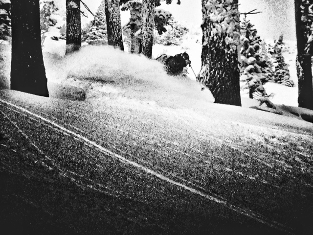
"Testing the snow" on ACB - Photo: N Meyers
VIDEOS of ECT tests performed on 12.13.15:
Pit profile below from December 13, 2015:
The Sand Flat cross country ski trails are snow covered and ready for your cross country skis. These are backcountry trails marked with blue diamonds on trees. Trails are not groomed. Enjoy!
The Five Red Flags of Avalanche Danger any time of year include: 1) Recent/current avalanche activity 2) Whumpfing sounds or shooting cracks 3) Recent/current heavy snowfall 4) Strong winds transporting snow 5) Rapid warming or rain on snow.
Weather and Current Conditions
Weather Summary
Good Morning! In Mt Shasta City at 0500, we have a current temperature of 28 F, overcast skies and and light wind, 0-5 mph.
MOUNTAIN WEATHER STATION INFORMATION (0500hrs):
On Mt Shasta (South Side) in the last 24 hours...
Old Ski Bowl - 7,600 feet, the current temperature is 24 degrees F. Snow on the ground totals 29 inches with no new snow in the last 24 hours and 3 inches of settlement. Temperatures have ranged from 22 F to 32 F.
Gray Butte - 8,000 feet, the current temperature is 25 degrees F. Temperatures have ranged from 22 F to 30 F in the last 24 hours. Westerly winds have been blowing at 35-55 mph with gusts to 78 mph up until 1300 when they died down and averaged 5 mph and variable in direction.
Mt Eddy Range (West side of Interstate-5)...
Castle Lake - 5,600 feet, the current temperature is 22 degrees F. Temperatures have ranged from 17 F to 26 F in the last 24 hours. Snow on the ground measures 16 inches with no new snow and 1 inch settlement.
Mt Eddy - 6,500 feet, the current temperature is 26 degrees F. Temperatures have ranged from 16 F to 27 F. Snow on the ground measures 33 inches with no new snow in the last 24 hours and no settlement. Winds have averaged 3 mph and Southerly in direction with a max gust to 15 mph, SSW.
Always check the weather before you attempt to climb Mt Shasta. Further, monitor the weather as you climb. Becoming caught on the mountain in any type of weather can compromise life and limb. Be prepared.
| 0600 temperature: | 21 |
| Max. temperature in the last 24 hours: | 26 |
| Average wind direction during the last 24 hours: | Westerly |
| Average wind speed during the last 24 hours: | 30-35 mph until 1300, then 3-5 mi/hr |
| Maximum wind gust in the last 24 hours: | 78 mi/hr |
| New snowfall in the last 24 hours: | 0 inches |
| Total snow depth: | 29 inches |
Two Day Mountain Weather Forecast
Produced in partnership with the Medford NWS
| For 7000 ft to 9000 ft | |||
|---|---|---|---|
|
Wednesday (4 a.m. to 10 p.m.) |
Wednesday Night (10 p.m. to 4 a.m.) |
Thursday (4 a.m. to 10 p.m.) |
|
| Weather | Mostly cloudy, blustery | Mostly cloudy, Snow likely before 4 am, then snow likely, possibly mixed with rain and freezing rain | Partly to mostly cloudy |
| Temperature (°F) | 32 | 28 | 32 |
| Wind (mi/hr) | North, then shifting to the West late afternoon 10-15 mph | West, then becoming South early Thurs. 10-15 mph with gusts to 20+ mph | South 10-15 mph with gusts to 20+ mph |
| Precipitation SWE / Snowfall (in) | / 0 | / 1-3 | / 1-2 |
| For 9000 ft to 11000 ft | |||
| Wednesday | Wednesday Night | Thursday | |
| Weather | Mostly cloudy. Windy, wind chill values as low as -7 | Cloudy, snow likely before 4 am, then snow likely possibly mixed with rain. Windy, wind chill values as low as -4 | Partly to mostly cloudy, windy |
| Temperature (°F) | 22 | 24 | 27 |
| Wind (mi/hr) | Northwest 20-25 mph, gusts to 40+ mph | Northwest 0 | West 30-35 mph with gusts to |
| Precipitation SWE / Snowfall (in) | / 0 | / 1-3 | / 1-2 |

