

You are here
Avalanche Advisory for 2015-12-18 07:02:01
- EXPIRED ON December 19, 2015 @ 7:02 amPublished on December 18, 2015 @ 7:02 am
- Issued by Jon Dove - Shasta-Trinity National Forest
Bottom Line
Pockets of MODERATE avalanche danger exists above treeline where wind slabs are still present on loaded NE-E-SE-S-SW slopes. Pockets of CONSIDERABLE danger may be found on uniform, open W-SW-S-SE-E facing slopes steeper than 30 degrees, 7,500 to 8,500 feet near treeline. Near crust facets forming a persistent weak layer, 40-50cm deep in the snowpack, are still a concern.
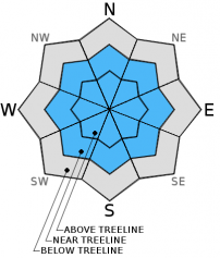
Below treeline, the avalanche danger is LOW


Avalanche Problem 1: Persistent Slab
-
Character ?

-
Aspect/Elevation ?
-
Likelihood ?CertainVery LikelyLikelyPossible
 Unlikely
 -
Size ?HistoricVery LargeLargeSmall

The obvious sensitivity of the persistent weak layer displayed by stability test results from December 13th (see videos) and then again on Dec. 16th has added an interesting twist to our current snowpack structure. We are continuing to monitor and investigate the distribution of this persistent weak slap avalanche problem. The persistent weak layer has resulted in an air of caution amongst backcountry skiers/riders/snowmobilers. Rightly so because it is an avalanche problem that is most often not an issue with our maritime (wetter) snowpack. This caution is warranted as the sensitivity to added weight and disturbance to the snowpack in areas where the right combination of factors exist could result in an avalanche. Reports of slide activity caused by heavy OSV equipment a couple of days ago on the the SSW aspect of Grey Butte indicate that the weak layer can fail with the right trigger. It is a sensitivity that may not be as stubborn to trigger as previously thought. The lack of prior evidence of this "sensitive" persistent weak layer is perhaps the result of our still shallow snowpack. The weak layer bed surface is not uniform and planar due to many ground protrusions still poking up into the snowpack disrupting uniform distribution. This fact will limit the size of slabs that may release if triggered to being small. It does not take much snow, however, to push you into trees or over other obstacles. Size does not matter. In the right circumstances a small slide can still bury you!
We do believe the persistent slab problem still remains an issue, especially with continued cold temperatures. Persistent weak slab formations may still be present on the aspects listed above in the 7,500-8,500 ft. elevations near treeline. Some variability and uncertainty surrounds persistent weak layers and persistent slab avalanches. While it remains difficult for a person on foot to trigger an avalanche on this layer, if a user happens upon the right combination of weak layer with slab on top, and the right trigger point, it remains possible. Hopefully the facet growth will cease and the snow crystals will begin to round and bond with some melting influenced by warmer temps.
For today, continue to avoid wide open, smooth and planar looking slopes just below, near and slightly above treeline in the 7,500 to 8,500 ft. elevation areas. Large triggers like multiple people tightly spaced on a slope or a snowmobile would have better chances of possibly triggering a persistent slab. The presence or absence of the avalanche problem will vary widely from one location to another due to depth of snow, aspect and elevation, and ground anchors/protrusions. The persistent weak layer has been found on NW-W-SW-S-SE facing slopes in this elevation band. Unfortunately, we cannot nail this weak layer down perfectly. It is your responsibility to get your shovel out, dig a pit and identify the presence or absence of the weak layer. Conduct a few stability tests before considering skiing or riding on suspect slopes! Be observant, be cautious, and travel accordingly.
Avalanche Problem 2: Wind Slab
-
Character ?

-
Aspect/Elevation ?

-
Likelihood ?CertainVery LikelyLikelyPossible
Unlikely
-
Size ?HistoricVery LargeLargeSmall
Strong northerly winds with the last storm cycle (Dec. 12th-13th) transported snow onto NE-E-SE-S-SW aspects. Observations made yesterday at treeline along the edge of Sun Bowl indicated that over the past couple of days wind slabs have had to opportunity to bond with underlying snow. This may not, however, be the rule as one ascends higher on the mountain where colder, windier conditions may have prevented bonding. Winds were strong enough that the usual areas along ridge tops where wind slabs typically deposit have been wind scoured. Wind slabs have been deposited further down the slope below traditional avalanche start zones as well as creating shallow wind slabs near treeline. Avoid these areas by traveling in areas less than 30 degrees in slope angle without steeper terrain above. Even on scoured, windward aspects small wind slabs can develop which was observed while traversing along Broadway towards Sun Bowl. We've seen the full spectrum of wind loading on all aspects. Local orographics allow non-typical aspects to wind load on Mt Shasta. Over the course of the past week, we've had wind from all directions though the highest wind speeds have been blowing from the north/northwest. Once again, uncertainty exists for wind slab sensitivity to triggering due to lack of upper elevation observations. Watch out for near and above treeline terrain near/below ridgetops, on the leeward side of rocks and tree outcrops, round/hollow sounding snow pillows, shooting cracks, narrow couloirs and extreme terrain.
Forecast Discussion
Snow levels will fall today as a cold front moves through the region. A "winter weather advisory" and a "winter storm warning" are in effect due to this snow combined with gusty winds. Precipitation rates will increase this morning to close to 0.10" of water per hour! Precipitation models forecast up to 1.18 inches of total water amounts today. Snow will drop to the valley floor bringing potential for up to 3 inches of snow in Mt. Shasta City. Above 4,000 ft. in excess of 6 inches could fall with the greatest amounts this morning. Tonight through tomorrow a cold pool of air in the 500 mb (18,000 ft) range will drift across the area dropping snow levels further, down to 2,500 ft with light accumulations. Based on precipitation amounts forecast, Saturday will be a bit of a break in between storm systems. Late Saturday into Sunday cold air continues keeping snow levels low in the 2,000-3,000 ft range. The precipitation with this system will be modest, in the vicinity of 0.35" of water. The extended outlook into early next week looks to be wet with a potentially significant storm on Monday into early Tuesday. We'll keep our fingers crossed!
High winds today will calm overnight, into Saturday during the break between systems, then ramping back up Sunday as the next two system move through the area.
THIS SEASON PRECIPITATION: Since October 1st (the wet season), we have received 7.21 inches of water, normal is 11.48 inches, putting us at 62% of normal. For the month of December, we have received 5.18 inches of water, normal is 4.12 putting us at 125% of normal. For the year of 2015 we've received 24.39 inches of water, normal is 39.48 inches putting us at 61% of normal.
Recent Observations
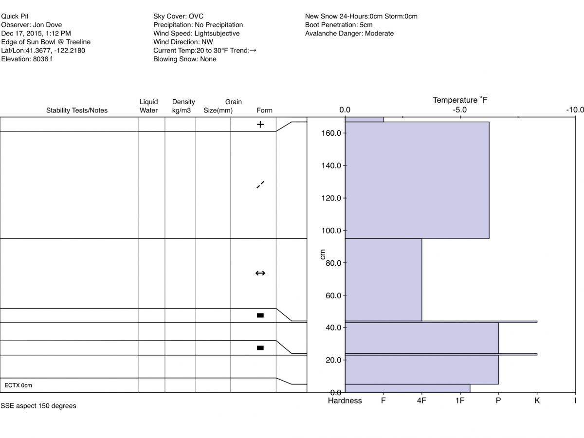
In the effort to investigate the existance or absence of the persistant weak layer found in the 7,500-8,500 ft range near treeline I ski toured up Green Butte ridge yesterday to treeline. Traversing across Broadway towards Sun Bowl revealed firm, wind scoured snow conditions with spotty wind slab "pillows" which is not uncommon for this area. I stopped and dug a snow pit just over the edge where Broadway falls into Sun Bowl close to the area known as "Gerald's Bowl" right at treeline. I chose a spot at an elevation of just over 8,000 ft. on a SSE aspect with a slope angel of 29 degrees. Snow depth at this location measured 170 cm with significant wind deposited snow composing the top 72 cm. An extended column test resulted in a score of ECTX meaning I had no results in 30 taps to the shovel blade. The rain crust that composes the weak, reactive, partially faceted layer found on Grey Butte was not present. The red flag that I noticed in the snowpack structure observed in this pit is the fact that the wind deposited snow in the top 72 cm is more dense than the underlying new snow layer (pencil vs. 1 finger). The density change interface at 95cm sheard off when I pulled on the column after performing the EC test. What this says to me is that at least some of the wind slab formations on NE-E-SE-S aspects above treeline would be stubborn to trigger. Calm weather over the past couple of days has allowed wind slabs to begin to bond to the underlying snow. However, wind slab sesitivity may change as one ascends higher on the mountain. Stormy weather and poor visibility will keep folks off of these aspects for today.
The fact that the weak layer of interest was not found at this location does not mean that the persistant slab avalanche problem no longer exists or is no longer a concern. It was reported yesterday that earlier in the week (approx. Tues) a snow cat that was traversing along a road on the southerly aspect of Grey Butte behind the Mt. Shasta Ski Park was triggering multiple slab releases as it traveled upward. Temperatures have remained cold at elevations where the persistan weak layer is present keeping the partially faceted snow crystals from rounding and bonding. This means that persistant weak slab instabilities are still a hazard and should be evaluated before commiting to travel across or descending suspect slopes. Dig a snow pit and perform a stability test (ECT, propagation saw, etc.) to gauge an areas sensitivity to extra loading. Avoid open and uniform slopes that may lack anchors such as large rocks, stumps, small trees, etc. over 30 degrees on S-SW-W-NW aspects.
Quick Pit from 12-17-2015 on the SSE aspect on the edge of Sun Bowl: Jon Dove
"Testing the snow" on ACB - Photo: N Meyers
VIDEOS of ECT tests performed on 12.13.15:
The Sand Flat cross country ski trails are snow covered and ready for your cross country skis. These are backcountry trails marked with blue diamonds on trees. Trails are not groomed. Enjoy!
The Five Red Flags of Avalanche Danger any time of year include: 1) Recent/current avalanche activity 2) Whumpfing sounds or shooting cracks 3) Recent/current heavy snowfall 4) Strong winds transporting snow 5) Rapid warming or rain on snow.
Weather and Current Conditions
Weather Summary
Good Morning! In Mt Shasta City at 0500, we have a current temperature of 35 F, with cloudy skies and and light rain/snow. Winds, 5-10 mph ESE.
MOUNTAIN WEATHER STATION INFORMATION (0500hrs):
On Mt Shasta (South Side) in the last 24 hours...
Old Ski Bowl - 7,600 feet, the current temperature is 24 degrees F. Snow on the ground totals 31 inches with one inch new snow in the last 24 hours. Temperatures have ranged from 22 F to 29 F.
Gray Butte - 8,000 feet, the current temperature is 24 degrees F. Temperatures have ranged from 20 F to 26 F in the last 24 hours. Winds, WNW shifting to SW, have been blowing at 20-30 mph with gusts to 42 mph, averaging 23 mph.
Mt Eddy Range (West side of Interstate-5)...
Castle Lake - 5,600 feet, the current temperature is 27 degrees F. Temperatures have ranged from 25 F to 35 F in the last 24 hours. Snow on the ground measures 17.5 inches with 1.5 inches new snow.
Mt Eddy - 6,500 feet, the current temperature is 28 degrees F. Temperatures have ranged from 22 F to 32 F. Snow on the ground measures 32 inches with 2 inches new snow in the last 24 hours and no settlement. Winds have averaged 2 mph and Southerly in direction with a max gust to 16 mph, SSW.
Always check the weather before you attempt to climb Mt Shasta. Further, monitor the weather as you climb. Becoming caught on the mountain in any type of weather can compromise life and limb. Be prepared.
| 0600 temperature: | 28 |
| Max. temperature in the last 24 hours: | 29 |
| Average wind direction during the last 24 hours: | WNW shifting to SW |
| Average wind speed during the last 24 hours: | 22 mi/hr |
| Maximum wind gust in the last 24 hours: | 42 mi/hr |
| New snowfall in the last 24 hours: | 1 inches |
| Total snow depth: | 31 inches |
Two Day Mountain Weather Forecast
Produced in partnership with the Medford NWS
| For 7000 ft to 9000 ft | |||
|---|---|---|---|
|
Friday (4 a.m. to 10 p.m.) |
Friday Night (10 p.m. to 4 a.m.) |
Saturday (4 a.m. to 10 p.m.) |
|
| Weather | Cloudy, snow. | Cloudy, snow showers | Mostly cloudy. Snow showers likely, mainly before 10 am. |
| Temperature (°F) | 31 falling around 25 | 21 | 26 |
| Wind (mi/hr) | South 15-20 mph with gusts to 25 mph | South 5-10 mph with gusts to 20 mph | Northwest 5-10 mph |
| Precipitation SWE / Snowfall (in) | / 7-11 | / 2-4 | / around 1 |
| For 9000 ft to 11000 ft | |||
| Friday | Friday Night | Saturday | |
| Weather | Cloudy, snow. Windy with wind chill values as low as -14 | Cloudy, snow showers. Windy with wind chill values as low as -14 | Mostly cloudy. Snow showers likely, mainly before 10 am. Breezy with wind chill values as low as -15 |
| Temperature (°F) | 21 | 14 | 10 |
| Wind (mi/hr) | South 30-35 mph, gusts to 45+ mph | Southwest 13-19 | West 15-20 mph with gusts to 60+ mph |
| Precipitation SWE / Snowfall (in) | / 13-19 | / 3-7 | / 1-3 |

