

You are here
Avalanche Advisory for 2015-12-19 07:04:51
- EXPIRED ON December 20, 2015 @ 7:04 amPublished on December 19, 2015 @ 7:04 am
- Issued by Nick Meyers - Shasta-Trinity National Forest
Bottom Line
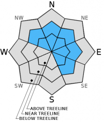
Below treeline, the avalanche danger is LOW.
Overall MODERATE danger exists for the forecast area. Wind slabs & our isolated persistent weak layer will present todays avalanche problems.
Wind slabs will be most prevalent on NW-N-NE-E-SE facing aspects near/above treeline.
The persistent weak layer can be found on isolated terrain features, 7,000 to 8,000 feet near treeline, W-SW-S-SE facing slopes.
The avalanche danger will increase as more snow adds weight to our persistent weak layer and depth/distribution to wind slabs.


Avalanche Problem 1: Wind Slab
-
Character ?

-
Aspect/Elevation ?
-
Likelihood ?CertainVery LikelyLikelyPossible
 Unlikely
 -
Size ?HistoricVery LargeLargeSmall

South/Southwest winds have been blowing over the past 24 hours averaging 20 mph and gusting to near 50mph. Small to large wind slabs are likely to have formed on leeward NW-N-NE-E-SE aspects near and mostly above treeline. Variable density changes in said wind slabs, specifically ligher density snow underlying a denser wind slab could be cause for a skier/snowmobiler triggered slide today. Shooting cracks, hollow "drumlike" sounding snow are good signs that your in wind slab country. Hard, wind slabs are notoriously unpredictable. Tread lightly! Remember that high wind speeds can load slopes much further down than expected, creating mid-slope starting zones.
Avalanche Problem 2: Persistent Slab
-
Character ?

-
Aspect/Elevation ?
-
Likelihood ?CertainVery LikelyLikelyPossible
Unlikely
-
Size ?HistoricVery LargeLargeSmall
Triggering a slab on the December 13th persistent weak layer is unlikely today. Where the PWL has been located, stability tests have shown both stable AND unstable results. That said, propagation on a slope scale does not seem probable. Steady snowfall has deepened our snowpack and warmer temperatures overall have allowed the PWL to heal and no longer present a problem. As mentioned though, variability and uncertainty surround the 12-13 weak layer. Any avalanches involving this weak layer we think will be isolated, small and hard to trigger today, but not impossible. Snow continues to fall and increase slab size on top of weak layer, increasing consequences should it fail, even if just a small avalanche.
Forecast Discussion
I find myself grinning and shaking my head in amazement as storms continue to flow off the conveyor belt and into the Mt Shasta area. Oh how sweet it is to have a normal winter. Todays weather will serve a brief respite in winter storms. We may see a piece of the sky for a moment, but most of the day will host light snow showers and a couple inches of accumulation on the hill. Winds will not be to bad today, however will kick up Sunday as the next storm front pushes over head. This next system will bring another dollup of snow to the forecast area along with windy conditions. Another .5 inches of precipitation is forecasted with snow levels to town and perhaps lower. We could see another 5-7 inches on the mountain over the course of the day tomorrow. The extended... Snow is "in the box" as far out as we can see! Happy Holidays!
THIS SEASON PRECIPITATION: Since October 1st (the wet season), we have received 8.07 inches of water, normal is 11.75 inches, putting us at 68% of normal. For the month of December, we have received 6.04 inches of water, normal is 4.39 putting us at 137% of normal. For the year of 2015 we've received 25.25 inches of water, normal is 39.75 inches putting us at 63% of normal.
Recent Observations
Professional observations/stability tests and a few reports from local observers have given us a wide range of information and it's making it difficult to nail down a danger rating. On Gray Butte yesterday (12/18), a couple ECT tests were performed in the same area where our persistent weak layer was first found on December 13th and resulted in ECTP14 Q2 at the rain crust layer where facets still remain. This aspect faces westerly, just below treeline. Jon's pit and tests near/above treeline from two days ago (12/17) in the Gerald's Bowl/Sun Bowl area, southerly facing, gave stable results (ECTX). Another report yesterday (12/18) from near/below treeline over in the "Promise Land" area near Horse Camp and below Giddy Giddy Gulch (S/SW facing, 7,500 ft) resulted in ECTP5 Q2 on the persistent weak layer of discussion lately. So, a bit of a mixed bag of results.
Overall, recent observations are showing a stregthening snowpack due to warmer temperatures and a deeper snowpack allowing old persistent weak layer(s) to heal and no longer present a major problem. Variability and uncertainty are the two words that come to mind surrounding the December 13th persistent weak layer. Most stability tests have indicated that the layer has become dormant, though a few tests still show unstable results.
Yesterday, 10-12 inches of new snow fell on the mountain and no new instabilities were observed. South/Southwest winds averaged 20mph and frequent gusts to 40-50 mph, south/southwest prevailed on Gray Butte, 8,000 feet. Wind slabs are always a given on Mt Shasta. Thick, dense wind slabs have been observed with variable densities in the slab.
___________________________________________________________________________________________________________________________________________________________________________
The Sand Flat cross country ski trails are snow covered and ready for your cross country skis. These are backcountry trails marked with blue diamonds on trees. Trails are not groomed. Enjoy!
The Pilgrim Creek Snowmobile trails will be groomed soon! Head to our "Education" tab on our website and find the snowmobile section for trail information and other sledder resources!
The Five Red Flags of Avalanche Danger any time of year include: 1) Recent/current avalanche activity 2) Whumpfing sounds or shooting cracks 3) Recent/current heavy snowfall 4) Strong winds transporting snow 5) Rapid warming or rain on snow.
Weather and Current Conditions
Weather Summary
Good Morning! In Mt Shasta City at 0500, we have a current temperature of 34 F, with cloudy skies and and light rain/snow and calm winds.
MOUNTAIN WEATHER STATION INFORMATION (0500hrs):
On Mt Shasta (South Side) in the last 24 hours...
Old Ski Bowl - 7,600 feet, the current temperature is 21 degrees F. Snow on the ground totals 41 inches with 11 inches new snow in the last 24 hours and 1 inch settlement. Temperatures have ranged from 21 F to 24 F.
Gray Butte - 8,000 feet, the current temperature is 20 degrees F. Temperatures have ranged from 20 F to 23 F in the last 24 hours. Winds have been averaging 20 mph out of the west with a max gust to 49 mph, southwest.
Mt Eddy Range (West side of Interstate-5)...
Castle Lake - 5,600 feet, the current temperature is 26 degrees F. Temperatures have ranged from 26 F to 27 F in the last 24 hours. Snow on the ground measures 24 inches with 7 inches new snow and 1 inch settlement.
Mt Eddy - 6,500 feet, the current temperature is 24 degrees F. Temperatures have ranged from 23 F to 27 F. Snow on the ground measures about 40 inches with 7 inches new snow in the last 24 hours and 1 inch settlement. Winds have averaged 2 mph and southerly in direction with a max gust to 16 mph, SSW.
Always check the weather before you attempt to climb Mt Shasta. Further, monitor the weather as you climb. Becoming caught on the mountain in any type of weather can compromise life and limb. Be prepared.
| 0600 temperature: | 24 |
| Max. temperature in the last 24 hours: | 27 |
| Average wind direction during the last 24 hours: | Southwesterly |
| Average wind speed during the last 24 hours: | 15-20 mi/hr |
| Maximum wind gust in the last 24 hours: | 49 mi/hr |
| New snowfall in the last 24 hours: | 11 inches |
| Total snow depth: | 41 inches |
Two Day Mountain Weather Forecast
Produced in partnership with the Medford NWS
| For 7000 ft to 9000 ft | |||
|---|---|---|---|
|
Saturday (4 a.m. to 10 p.m.) |
Saturday Night (10 p.m. to 4 a.m.) |
Sunday (4 a.m. to 10 p.m.) |
|
| Weather | Snow showers, mainly before 10am | Slight chance of snow showers before 10am, then snow after 4am. | Snow before 10am, then snow showers between 10am and 4pm. WIndy. |
| Temperature (°F) | 26 | 21 | 28 |
| Wind (mi/hr) | South/southwest becoming northwest in the morning 5-10 mph | South 10-15 mph | South/Southwest 15-25 mph - G 35 |
| Precipitation SWE / Snowfall (in) | / 1-3 | / 1-3 | / 3-5 |
| For 9000 ft to 11000 ft | |||
| Saturday | Saturday Night | Sunday | |
| Weather | Snow showers, mainly before 10am. Temps falling to about 8 by 7am. Breezy | A slight chance of snow showers before 10pm, then snow, mainly after 4am. Windy | Snow before 10am, then snow showers, mainly between 10am and 4pm. Windy. |
| Temperature (°F) | 8 | 8 | 19 |
| Wind (mi/hr) | West/Southwest 10-15 mph, G 20-30+ | West 2-4 | West 40-50 mph, G 60-70+ |
| Precipitation SWE / Snowfall (in) | / 2-4 | / 2-4 | / 4-8 |

