

You are here
Avalanche Advisory for 2015-12-20 07:02:39
- EXPIRED ON December 21, 2015 @ 7:02 amPublished on December 20, 2015 @ 7:02 am
- Issued by Jon Dove - Shasta-Trinity National Forest
Bottom Line
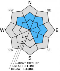
LOW avalanche danger exists for below, near, and above teeline on all aspects. Wind slabs & our isolated persistent weak layer will present todays avalanche problems.
Wind slabs will be most prevalent on NW-N-NE-E-SE facing aspects near/above treeline.
The persistent weak layer can be found on isolated terrain features, 7,000 to 8,000 feet near treeline, W-SW-S-SE facing slopes.
The avalanche danger will increase with added snow from the storms today and Monday.


Avalanche Problem 1: Wind Slab
-
Character ?

-
Aspect/Elevation ?
-
Likelihood ?CertainVery LikelyLikelyPossible
 Unlikely
 -
Size ?HistoricVery LargeLargeSmall

The wind slab avalanche problem has been becoming less so as slab layers bond with underlying old snow. Any lingering wind slab formations will be on leeward NW-N-NE-E-SE aspects near and mostly above treeline. Variable density changes in said wind slabs, specifically lighter density snow underlying a denser wind slab could be cause for a skier/snowmobiler triggered slide today. Shooting cracks, hollow "drum like" sounding snow are good signs that your in wind slab country. Hard, wind slabs are notoriously unpredictable. Tread lightly! Remember that high wind speeds can load slopes much further down than expected, creating mid-slope starting zones. Wind slab avalanche instabilities will increase with the coming storms and high winds.
Avalanche Problem 2: Persistent Slab
-
Character ?

-
Aspect/Elevation ?
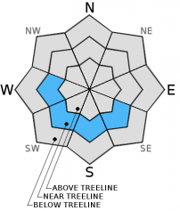
-
Likelihood ?CertainVery LikelyLikelyPossible
Unlikely
-
Size ?HistoricVery LargeLargeSmall
Triggering a slab on the December 13th persistent weak layer is unlikely today. Where the PWL has been located, stability tests performed yesterday (12-19-2015) are showning more stable results. Failure of the PWL and propagation on a slope scale does not seem probable. Up to 12 inches of new snowfall from Friday (Dec. 18th) has deepened our snowpack and warmer temperatures overall have allowed the PWL to heal and no longer present a serious problem. Extended column tests performed yesterday on Grey Butte resuted in scores of ECTP 21-25. As mentioned though, variability and uncertainty surround the weak layer. Any avalanches involving this weak layer we think will be isolated, small and hard to trigger today, but not impossible. Trigger points may exist on slopes steeper than 35 degrees around shallow buried objects. Snow continues to fall today and increase slab size on top of the weak layer, increasing consequences should it fail, even if just a small avalanche.
Forecast Discussion
Good ole' Mother Nature has been kind to the "State of Jefferson" this December, and the gifts will keep coming for the Holidays! Speaking of gifts, a "winter weather advisory" is in affect as light snow has begun to fall early this morning. Snow, moderate in intensity, is expected to continue through this afternoon. This storm is forecast to be followed by another major storm on Monday stretching into early Tuesday. Precipitation amounts for today's storm could total close to half an inch of water translating into 5-6 inches of snow! But that's not all folks! Monday's storm is projected to be packing a wet 1.5+ inches of water meaning snow totals could fall somewhere between 14-16 inches of snow. Did I hear someone say "Powder"? It should be noted that snow levels with Monday's storm will start off low and then climb. Models forecast an end snow level elevation close to 6,000 ft., however, intense precip amounts tend to cool the air and lower snow levels, so I would not be surprised if levels only rise to 4,500-5,000 ft. The extended outlook for the end of this week around the Holiday looks to be promising a white Christmas for lower elevations. We'll see if Santa can deliver. An overall wet weather pattern is expected, so keep you fires stoked!
THIS SEASON PRECIPITATION: Since October 1st (the wet season), we have received 8.07 inches of water, normal is 12.04 inches, putting us at 67% of normal. For the month of December, we have received 6.04 inches of water, normal is 4.68 putting us at 129% of normal. For the year of 2015 we've received 25.25 inches of water, normal is 40.04 inches putting us at 63% of normal.
Recent Observations
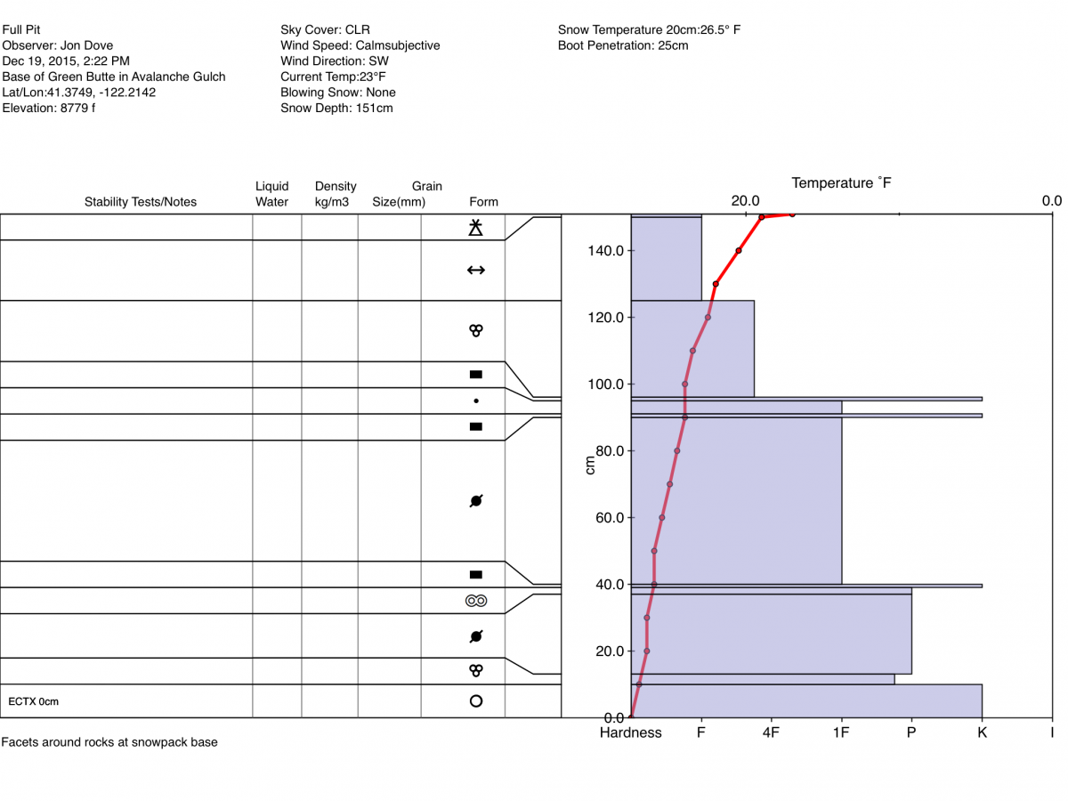
Observations were made in several locations on Mt. Shasta yesterday in an effort to gauge any changes to, or the existence of the PWL (persistent weak layer) in the snowpack structure. A ski tour up Broadway was a pleasure with mostly sunny skies with the occasional brief cloud bank. New snow amounts from Friday made for excellent skiing/riding on stable snow. A quick ECT (extended column test) was performed at the top of the easterly aspect that drops into Old Ski Bowl resulting in an a score of ECTX (no failure). This was our first look at the stability of slopes above treeline. I dug a snow pit at the base of the westerly aspect of Green Butte Ridge that falls into Avalanche Gulch at approximately 8775 ft. to perform a full profile and conduct stability tests. I found the crust layer that has been producing the PWL at lower elevations (7,000-8,000 ft.) on similar aspects, however, the faceting of snow crystals within this layer was not present. Additionally, the depth of the crust layer combined with a "right side up" (softer snow layers lying on top of denser layers) structure in the density of the snow layers is resulting in a strengthening snow pack with no obvious weak layers. This hypothesis was confirmed with multiple ECT's all with no results.
Observations of the snow on the WSW aspect of Grey Butte where the PWL has been most present also revealed a strengthening snowpack with multiple extended column tests resulting with scores of ECTP 21-25. What this says is that the PWL still exists, but is healing up with the weight of added snow on top and more bonding of the crystals within and around the crust layer. Another thing to note is that when the weak layer failed it did not "pop" but it did "drop". What this means is that there is no longer a lot of energy built up in the layer, hence the lack of a "pop" during failure. It did "drop" though which says that there is still a slight weakness within the layer, and the crystals can collapse. This PWL is stubborn to trigger, however, caution should be taken when choosing your line. Multiple people tightly spaced, or a snowmobile cutting across the right trigger point in an isolated spot in steeper terrain could still result in causing an avalanche.
Avalanche danger will rise with additional snow fall from current and expected storms forecast for early today and then on Monday. Monday's storm will bring the greatest chance for storm slab instabilities as the storm is forecast to be "upside down" meaning it will start off with cold air then warm up as the storm passes leaving colder, drier snow underneath wetter, heavier snow.
Full Pit Profile @ base of Green Butte Ridge in Avalanche Gulch from 12-19-2015 by Jon Dove
___________________________________________________________________________________________________________________________________________________________________________
The Sand Flat cross country ski trails are snow covered and ready for your cross country skis or snow shoes. These are backcountry trails marked with blue diamonds on trees. Trails are not groomed. Snow shoers, please blaze a parallel trail to cross country skiers staying out of the skin track. Thank you, and Enjoy!
The Pilgrim Creek Snowmobile trails will be groomed soon! Head to our "Education" tab on our website and find the snowmobile section for trail information and other sledder resources!
The Five Red Flags of Avalanche Danger any time of year include: 1) Recent/current avalanche activity 2) Whumpfing sounds or shooting cracks 3) Recent/current heavy snowfall 4) Strong winds transporting snow 5) Rapid warming or rain on snow.
Weather and Current Conditions
Weather Summary
Good Morning! In Mt Shasta City at 0500, we have a current temperature of 32 F, with cloudy skies and light/moderate snow and light winds 5-10 mph,.
MOUNTAIN WEATHER STATION INFORMATION (0500hrs):
On Mt Shasta (South Side) in the last 24 hours...
Old Ski Bowl - 7,600 feet, the current temperature is 16 degrees F. Snow on the ground totals 40 inches with a trace of new snow in the last 24 hours and 1 inch settlement. Temperatures have ranged from 11 F to 28 F.
Gray Butte - 8,000 feet, the current temperature is 15 degrees F. Temperatures have ranged from 11 F to 27 F in the last 24 hours. Winds have been averaging 10 mph, westerly in direction with a max gust to 28 mph, west/southwest.
Mt Eddy Range (West side of Interstate-5)...
Castle Lake - 5,600 feet, the current temperature is 22 degrees F. Temperatures have ranged from 20 F to 26 F in the last 24 hours. Snow on the ground measures 23 inches with a trace of new snow and 1 inch settlement.
Mt Eddy - 6,500 feet, the current temperature is 20 degrees F. Temperatures have ranged from 12 F to 24 F. Snow on the ground measures about 40 inches with a trace of new snow in the last 24 hours and 1 inch settlement. Winds have averaged 2 mph and variable in direction with a max gust to 8 mph, SE.
Always check the weather before you attempt to climb Mt Shasta. Further, monitor the weather as you climb. Becoming caught on the mountain in any type of weather can compromise life and limb. Be prepared.
| 0600 temperature: | 19 |
| Max. temperature in the last 24 hours: | 26 |
| Average wind direction during the last 24 hours: | Variable |
| Average wind speed during the last 24 hours: | 10-15 mi/hr |
| Maximum wind gust in the last 24 hours: | 28 mi/hr |
| New snowfall in the last 24 hours: | trace inches |
| Total snow depth: | 40 inches |
Two Day Mountain Weather Forecast
Produced in partnership with the Medford NWS
| For 7000 ft to 9000 ft | |||
|---|---|---|---|
|
Sunday (4 a.m. to 10 p.m.) |
Sunday Night (10 p.m. to 4 a.m.) |
Monday (4 a.m. to 10 p.m.) |
|
| Weather | Cloudy, snow. Windy | Cloudy. Snow showers likely, mainly before 10 pm, then snow after 4 am | Cloudy, snow. Windy |
| Temperature (°F) | 27 | 23 | 33 |
| Wind (mi/hr) | South 5-10 mph | Southwest 10-15 mph | South 15-25 mph - G 35 |
| Precipitation SWE / Snowfall (in) | / 6-10 | / 1-3 | / 7-11 |
| For 9000 ft to 11000 ft | |||
| Sunday | Sunday Night | Monday | |
| Weather | Cloudy, snow. The snow could be heavy at times. Windy with wind chill values as low as -8. | Cloudy. Snow showers likely, mainly before 10 pm, then snow after 4 am. Windy with wind chill values as low as -8. | Cloudy, snow. Snow could be heavy at times. Windy with wind chill values as low as -8. |
| Temperature (°F) | 20 | 20 | 23 |
| Wind (mi/hr) | West 45-50 mph with gusts to 60+ mph | West 7-11 | West 65-70 mph with gusts to 80+ |
| Precipitation SWE / Snowfall (in) | / 7-11 | / 2-4 | / 10-14 |

