

You are here
Avalanche Advisory for 2015-12-21 07:07:34
- EXPIRED ON December 22, 2015 @ 7:07 amPublished on December 21, 2015 @ 7:07 am
- Issued by Nick Meyers - Shasta-Trinity National Forest
Bottom Line
A winter storm warning is in effect today. One to two feet of new snow and very strong westerly winds will ensue over the next 48 hours.
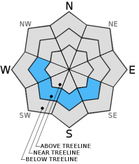
Today, LOW avalanche danger will exist on all aspects below treeline.
Near and above treeline, overall MODERATE avalanche danger will exist, all aspects.
Pockets of CONSIDERABLE avalanche danger for wind slab avalanches on NE-E-SE facing slopes may be encountered near/above treeline.


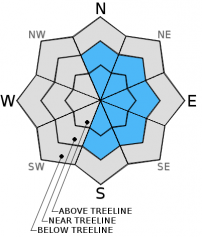
Avalanche Problem 1: Wind Slab
-
Character ?

-
Aspect/Elevation ?

-
Likelihood ?CertainVery LikelyLikelyPossible
 Unlikely
 -
Size ?HistoricVery LargeLargeSmall

West winds are already blowing an average of 15-20 mph this morning on Gray Butte, 8,000 feet on Mt Shasta, gusting to 30-40 mph. Westerly winds will increase and reach average speeds of 40-50 mph with gusts to 70-80 mph over the next 24-48 hours with 1-2 feet of new snow expected. This will make for ripe wind slab formation conditions. While ridge tops will likely stay scoured due to extreme wind speeds, mid slope areas could host wind slabs in non-typical starting zones. Easterly aspects near and above treeline will host the best chance of wind slab formation, though local orographics making funky wind eddies will load other aspects. Use visual clues such as blowing snow, cornice formation, wind pillows and cracking along ridgelines/extreme terrain/couloirs to determine where wind slabs exist. Wind slabs are often limited by terrain and usually have well defined boundaries.
Avalanche Problem 2: Persistent Slab
-
Character ?

-
Aspect/Elevation ?
-
Likelihood ?CertainVery LikelyLikelyPossible
Unlikely
-
Size ?HistoricVery LargeLargeSmall
It is unlikely that a single skier will trigger an avalanche on the persistent weak layer from December 13th and stability tests in areas where the layer has been observed have shown more stable results. However, the skeleton is in the closet. Should a snowmobile, multiple people on a slope and/or more snow add enough stress to initiate fracture of said PWL, the consequences could be big. In these isolated areas where the PWL has been monitored, the right ingredients exist for a slide: slab over weak layer. Avoid complacency!! Tracks already on a slope do not mean it's safe. The "standard" skin track may not be in a safe location. Pay attention to slope and terrain at all times and make your own decisions!
Avalanche Problem 3: Cornice
-
Character ?

-
Aspect/Elevation ?
-
Likelihood ?CertainVery LikelyLikelyPossible
Unlikely
-
Size ?HistoricVery LargeLargeSmall
Cornice formation is likely with new snow and westerly winds. Stay back from the edge to avoid the elevator drop!
Forecast Discussion
A wet and wild storm knocks on our doorstep this morning as wind and light snow are already beginning to fall in town. This westerly moving storm will provide heavy precipitation at times and very windy conditions to the area, especially near and above treeline on Mt Shasta. For Monday and Tuesday, a precip total of 1.75 inches of water is projected which will translate into likely over a foot and perhaps even two feet of new snow over the next 48 hours. To be expected, wind will accompany the storm. Wind speeds look higher than normal with 50-60 mph westerly winds above treeline in exposed areas and gusts probable to 70-80+ mph. Were you thinking of climbing the mountain this week? Not a good idea. Temperatures will stay steady for the beginning of week before a cooling trend begins on Wednesday. For this storm upon us, snow levels are forecasted to be around 4,000 to 5,000 feet, though could likely be lower due to heavy snowfall amounts at times lowering the snow level. Overall, snow showers and wet weather is forecast for Christmas week and we sure hope Santa has polished Rudolph's nose as it will need to be shining bright in order to navigate the storms!
THIS SEASON PRECIPITATION: Since October 1st (the wet season), we have received 8.31 inches of water, normal is 12.32 inches, putting us at 67% of normal. For the month of December, we have received 6.28 inches of water, normal is 4.96 putting us at 126% of normal. For the year of 2015 we've received 25.49 inches of water, normal is 40.32 inches putting us at 63% of normal.
Recent Observations
Numerous observations were submitted from local skiers and have been made by Jon and I over the weekend. Overall, all observations have indicated a strengthening snowpack for both the persistent weak layer problem and wind slabs. Fabulous skiing was had by many as 11-12% powder, right side up, layered the mountain. The backcountry has been world class. The Mt Shasta Ski Park is also in full operation and skiers and riders grinning like kids on Christmas.
We've been monitoring the persistent weak layer problem closely, hunting to find new areas where the layer might exist and continuing to dig pit's and conduct stability test in areas we know the layer exists. The PWL has not been observed on any new aspects or elevations, however it still exists in areas where already observed from December 13th. Stability tests have trended toward stronger results, but I am still not convinced we should forget about it. The PWL, still just below the thin crust now deeper in the snowpack (70-90 cm snow over PWL), hosted rounded facets on 12/19 and fully propagated under hard hits from the shoulder (ECTP20-30). That said, uncertainty is still high concerning this layer and its future productivity for an avalanche in these isolated areas.. A few thoughts... 1 - The layer still exists in isolated areas just below treeline on W-SW-S-SE aspects. 2 - How much weight from either multiple people on a slope, or snowmobiler, would it take to trigger the PWL? 3 - If triggered, the snow above the PWL is only getting deeper and consequences getting bigger. So, the bottom line: Human triggered avalanches on this layer are unlikely today. BUT, in the locations where this weak layer is found, snowpit tests still indicate the right set of ingredients are in place for an avalanche to occur... read: slab over weak layer. Avoid multiple people on open slopes and consider the weight of your snowmobile (400+ lbs) when high marking in suspect areas. Further, heavy precipitation over the next 48 hours will deposit 1-2 feet of new snow adding more stress to the snowpack. Snow does not like rapid change!
Wind slabs have shown good stability in the past few days. Ridge tops remain scoured and firm. Small cornices have been easy to trigger but not of major concern nor have they triggered further slab avalanches. Easterly aspects have shown the best wind loading. The up and coming storm will deposit heavy snowfall and bring very strong westerly winds over the next 48 hours. Wind slabs are guaranteed and near and above treeline travel will call for careful route planning, if you can even see at all, let alone stand upright.
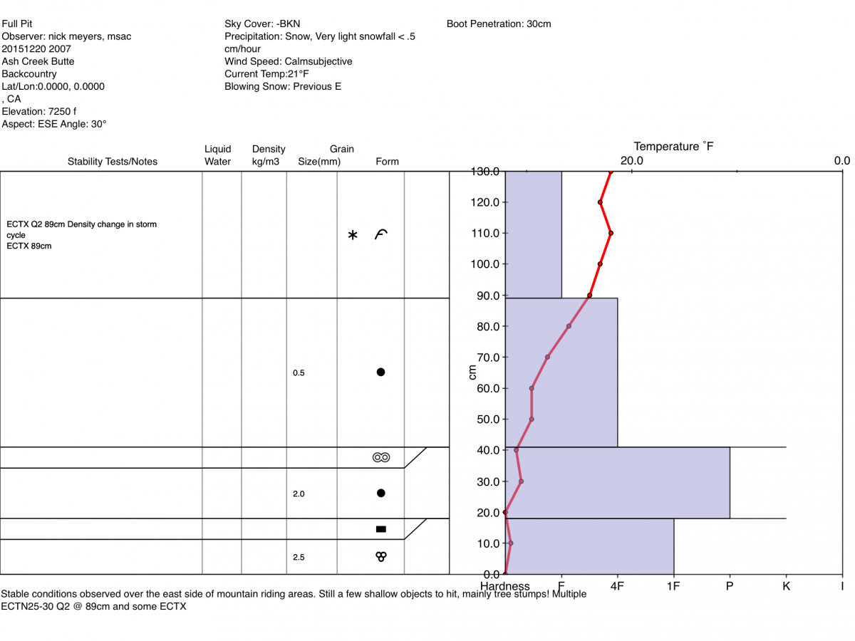
Below: Full pit profile from Ash Creek Butte area
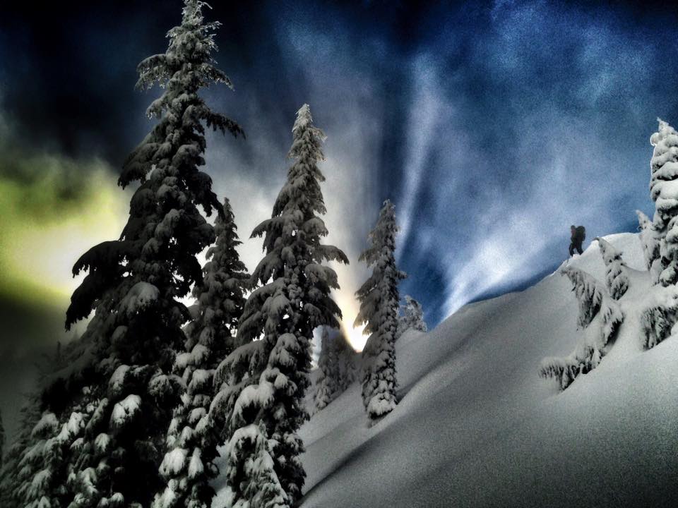
Skier: C Merrill Photo: N Meyers Location: Gray Butte
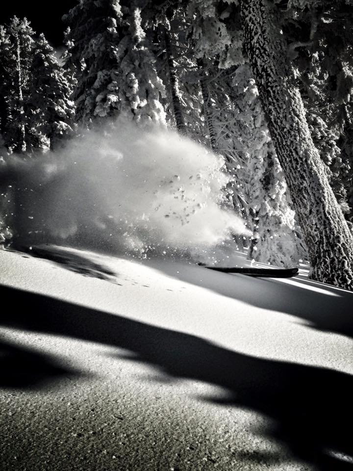
Skier: C Merrill Photo: N Meyers Location: Gray Butte
________________________________________________________________________________________________________________________________________________________________________
The Sand Flat cross country ski trails are snow covered and ready for your cross country skis or snow shoes. These are backcountry trails marked with blue diamonds on trees. Trails are not groomed. Snow shoers, please blaze a parallel trail to cross country skiers staying out of the skin track. Thank you, and Enjoy!
The Pilgrim Creek Snowmobile Park is open! Trails are being groomed currently. Head to our "Education" tab on our website and find the snowmobile section for trail information, grooming status and other sledder resources!
The Five Red Flags of Avalanche Danger any time of year include: 1) Recent/current avalanche activity 2) Whumpfing sounds or shooting cracks 3) Recent/current heavy snowfall 4) Strong winds transporting snow 5) Rapid warming or rain on snow.
Weather and Current Conditions
Weather Summary
Good Morning! In Mt Shasta City at 0500, we have a current temperature of 34 F, with cloudy skies and moderate snow / light winds.
MOUNTAIN WEATHER STATION INFORMATION (0500hrs):
On Mt Shasta (South Side) in the last 24 hours...
Old Ski Bowl - 7,600 feet, the current temperature is 19 degrees F. Snow on the ground totals 46 inches with 6 inches of new snow in the last 24 hours and 1 inch settlement. Temperatures have ranged from 16 F to 20 F.
Gray Butte - 8,000 feet, the current temperature is 18 degrees F. Temperatures have ranged from 15 F to 18 F in the last 24 hours. Winds have been averaging 15 mph, westerly in direction with a max gust to 42 mph, west.
Mt Eddy Range (West side of Interstate-5)...
Castle Lake - 5,600 feet, the current temperature is 25 degrees F. Temperatures have ranged from 21 F to 26 F in the last 24 hours. Snow on the ground measures 27 inches with 4-5 inches of new snow and 1 inch settlement.
Mt Eddy - 6,500 feet, the current temperature is 25 degrees F. Temperatures have ranged from 20 F to 25 F. Snow on the ground measures about 44 inches with 4 inches of new snow in the last 24 hours and 1 inch settlement. Winds have averaged 2 mph, southeast with a max gust to 11 mph, SE.
Always check the weather before you attempt to climb Mt Shasta. Further, monitor the weather as you climb. Becoming caught on the mountain in any type of weather can compromise life and limb. Be prepared.
| 0600 temperature: | 23 |
| Max. temperature in the last 24 hours: | 23 |
| Average wind direction during the last 24 hours: | Westerly |
| Average wind speed during the last 24 hours: | 10-15 mi/hr |
| Maximum wind gust in the last 24 hours: | 42 mi/hr |
| New snowfall in the last 24 hours: | 5-6 inches |
| Total snow depth: | 46 inches |
Two Day Mountain Weather Forecast
Produced in partnership with the Medford NWS
| For 7000 ft to 9000 ft | |||
|---|---|---|---|
|
Monday (4 a.m. to 10 p.m.) |
Monday Night (10 p.m. to 4 a.m.) |
Tuesday (4 a.m. to 10 p.m.) |
|
| Weather | Snow, heavy at times and windy | Snow, windy | Snow showers |
| Temperature (°F) | 32 | 28 | 35 |
| Wind (mi/hr) | South 20-30 mph | West 20-30 mph | West 10-15 mph |
| Precipitation SWE / Snowfall (in) | / 12-15 | / 5-7 | / 1-3 |
| For 9000 ft to 11000 ft | |||
| Monday | Monday Night | Tuesday | |
| Weather | Snow, heavy at times, windy | Snow, heavy at times, windy | Snow showers |
| Temperature (°F) | 23 | 18 | 17 |
| Wind (mi/hr) | West 50-60 mph | West/Northwest 12-17 | West/Northwest 30-40 mph |
| Precipitation SWE / Snowfall (in) | / 12-17 | / 9-12 | / 3-6 |

