

You are here
Avalanche Advisory for 2015-12-23 07:04:47
- EXPIRED ON December 24, 2015 @ 7:04 amPublished on December 23, 2015 @ 7:04 am
- Issued by Jon Dove - Shasta-Trinity National Forest
Bottom Line
A winter weather advisory in effect until late Thursday.
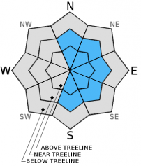
Today, LOW avalanche danger will exist on all aspects below treeline.
Near and above treeline, MODERATE avalanche danger will exist, all aspects.
Human triggered wind slab avalanches are possible on N-NE-E-SE-S facing slopes near/above treeline. Careful snowpack evaluation, conservative decision making, and cautious route finding remain essential.


Avalanche Problem 1: Wind Slab
-
Character ?

-
Aspect/Elevation ?
-
Likelihood ?CertainVery LikelyLikelyPossible
 Unlikely
 -
Size ?HistoricVery LargeLargeSmall

Steady West to Northwest winds of 20-30 mph with gusts up to 64 mph recorded over the last 24 at the Grey Butte weather station indicate that the conditions have been perfect for wind slab formation on N-NE-E-SE-S aspects. While ridge tops will likely have been scoured due to high wind speeds, mid slope areas could host wind slabs in non-typical starting zones. More Easterly facing aspects at near and above treeline elevations will have the best chance of harboring wind slab formation. However, it should be noted that local orographics can make some funky wind eddies that can load other aspects. Use visual clues such as blowing snow, cornice formation, wind pillows and cracking along ridge lines/extreme terrain/couloirs to determine where wind slabs might exist. Wind slabs are often limited by terrain and usually have well defined boundaries. Cornices may have formed in isolated areas along ridge tops pointing toward the leeward side. Give them a wide birth if encountered. A common place to find them would be along the north ridge of Grey Butte.
Avalanche Problem 2: Storm Slab
-
Character ?

-
Aspect/Elevation ?
-
Likelihood ?CertainVery LikelyLikelyPossible
Unlikely
-
Size ?HistoricVery LargeLargeSmall
The gradual warming trend at the tail end of Monday's generous storm system lasted through Tuesday allowing the 11-13 inches of new snow time to settle and bond with underlying snow. Moderate avalanche danger is still forecast for today, and danger may increase with additional new snow amounts over night. That being said the likelyhood of triggering a storm slab avalanche is unlikely unless the right trigger point is found. Storm slab avalanche danger may increase with significant additonal snow amounts forecast for late today into tonight.
Avalanche Problem 3: Persistent Slab
-
Character ?

-
Aspect/Elevation ?
-
Likelihood ?CertainVery LikelyLikelyPossible
Unlikely
-
Size ?HistoricVery LargeLargeSmall
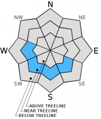
For the past ten days we have been monitoring the PWL that formed around the crust layer that developed the second week of December is showing signs that it has been deteriorating. Mt Shasta Ski Park Ski Patrol reported that from snow study pits dug in the vicinity of the ski area they found partially faceted snow crystals within the PWL going to rounds. Stability tests in areas where the layer has been observed have shown more stable results with extended column test results showing the layer to be stubborn to trigger and no propagation. However, due to spatial variability and lack of widespread observations, isolated pockets in steeper terrain at and just below treeline on W-SW-S-SE aspects may still host PWL sensitive enough to release at the right trigger point. Test results indicate that a single human triggering the PWL is unlikely though a snowmobile, multiple people on a slope, and/or more snow could add enough stress to initiate fracture of said PWL. If this were to happen the consequences could be big. In these isolated areas where the PWL has been monitored, the right ingredients exist for a slide: slab over weak layer. Avoid complacency!! Careful route finding, snowpack evaluation, and decision making are still necessary. Pay attention to slope and terrain at all times and make your own decisions!
Forecast Discussion
With mostly cloudy skies and no real precipitation to speak of, Tuesday acted as a break in between weather systems allowing folks to fully clear their driveways of Monday's snow drifts before the dropping temperatures froze everything solid. A "winter weather advisory" has been issued and is in effect until 4 pm Thursday. Moist onshore flow today will bring cold and wet weather to the area later today starting just before dark, around 4 pm, lasting into early Thursday. Precipitation models forecast total water amounts close to 0.8 inches which could translate into 6-9 inches of snow. Snow levels will reach the valley floor bringing snow to Mt. Shasta City for the Holidays! A lingering snow shower or two are possible on Thurday evening and Friday, but precipitation amounts will be light. An upper level ridge will push into the area as high pressure builds on Saturday. This will bring an inversion creating dense valley fog and cold overnight temperatures.
THIS SEASON PRECIPITATION: Since October 1st (the wet season), we have recieved 9.29 inches of water, normal is 12.88 inches, putting us at 72% of normal. For the month of December, we have received 7.26 inches of water, normal is 5.52 inches, putting us at 131% of normal. For the year of 2015 we've received 26.47 inches of water, normal is 40.88 inches, putting us at 64% of normal
Recent Observations
Observations from the field yesterday are limited to what was reported from Mt Shasta Ski Park Ski Patrol (a big "Thank You" for sharing information). Close to a foot of new snow fell on Monday forming storm slabs that were easy to trigger in steep rocky outcroppings in areas of the Ski Park such as the "Staircase" near Highland Glide. Mondays storm started cold and warmed as it passed. This allowed for slightly lighter, less dense snow under heavier, denser snow (think hard slab over soft). The continued relatively warmer temperatures on Tuesday helped the new snow to settle a bit and the crystals at the interface with the old snow to begin to round and bond. Storm slabs may become more of a problem if we receive the forecasted amount of new snow late today into early Thursday (6-9 inches).
Wind slabs are still a factor to consider. Wind slabs that were formed during the storm on S-SE-E-NE-N aspects may have grown due to continued high winds during the last 24 hours. Ridge tops remain scoured and firm. Small to medium size cornices may have formed on some ridge tops near treeline and may be easy to trigger. If traveling along a ridge where cornices have formed give them plenty of room. There is a slight chance that a cornice fall my trigger a storm slab or wind slab avalanche on slopes underneath on leeward aspects. Easterly aspects have shown the best wind loading. Continued high winds and additional storm activity will add more snow weight and stress on the leeward slopes listed above. Wind slabs are guaranteed and near and above treeline travel will call for careful route planning, if you can even see at all, let alone stand upright.
We've been keeping close track of the persistent weak layer problem digging snow study pits where the layer might exist and continuing to conduct stability test in areas where we know the layer exists. The PWL has not been observed on any new aspects or elevations, however it still exists in areas where already observed beginning on December 13th. Stability tests have shown results indicating a gradual strengthening within the PWL as partially faceted snow crystals melt and round. Has the added weight of heavy snow and the effect of warmer temperatures eliminated the hazard presented by this layer? There is still some uncertainty, but snow study pits today will hopefully shed more light on the question. If triggered, the snow above the PWL is only getting deeper with Mondays snow fall and more on the way. So, the bottom line: Human triggered avalanches on this layer are again unlikely today. In the locations where this weak layer is known to exist, a snow pit stability test would shed some light on any lingering sensitivity. Avoid multiple people clustered together on open slopes and consider the weight of your snowmobile (400+ lbs) when high marking in suspect areas. Consider the influence of the weight of the new snow plus a skier/rider or snowmobile adding more stress to the snowpack. Snow does not like rapid change!
________________________________________________________________________________________________________________________________________________________________________
The Sand Flat cross country ski trails are snow covered and ready for your cross country skis or snow shoes. These are backcountry trails marked with blue diamonds on trees. Trails are not groomed. Snow shoers, please blaze a parallel trail to cross country skiers staying out of the skin track. Thank you, and Enjoy!
The Pilgrim Creek Snowmobile Park is open! Trails are being groomed currently. Head to our "Education" tab on our website and find the snowmobile section for trail information, grooming status and other sledder resources!
The Five Red Flags of Avalanche Danger any time of year include: 1) Recent/current avalanche activity 2) Whumpfing sounds or shooting cracks 3) Recent/current heavy snowfall 4) Strong winds transporting snow 5) Rapid warming or rain on snow.
Weather and Current Conditions
Weather Summary
Good Morning! In Mt Shasta City at 0500, we have a current temperature of 34 F, overcast and calm winds.
MOUNTAIN WEATHER STATION INFORMATION (0500hrs):
On Mt Shasta (South Side) in the last 24 hours...
Old Ski Bowl - 7,600 feet, the current temperature is 16 degrees F. Snow on the ground totals 60 inches with 2 inches of new snow in the last 24 hours. Temperatures have ranged from 15 F to 31 F.
Gray Butte - 8,000 feet, the current temperature is 14 degrees F. Temperatures have ranged from 14 F to 29 F in the last 24 hours. Winds have been averaging 22 mph, NW in direction with a max gust to 64 mph, NNW.
Mt Eddy Range (West side of Interstate-5)...
Castle Lake - 5,600 feet, the current temperature is 21 degrees F. Temperatures have ranged from 21 F to 36 F in the last 24 hours. Snow on the ground measures 33 inches with no new snow, and 2 inches of settlement.
Mt Eddy - 6,500 feet, the current temperature is 20 degrees F. Temperatures have ranged from 20 F to 32 F. Snow on the ground measures about 50 inches with no new snow in the last 24 hours and 2 inches of settlement. Winds have averaged 3 mph, with a max gust to 15 mph, ESE.
Always check the weather before you attempt to climb Mt Shasta. Further, monitor the weather as you climb. Becoming caught on the mountain in any type of weather can compromise life and limb. Be prepared.
| 0600 temperature: | 20 |
| Max. temperature in the last 24 hours: | 33 |
| Average wind direction during the last 24 hours: | Northwest |
| Average wind speed during the last 24 hours: | 20-25 mi/hr |
| Maximum wind gust in the last 24 hours: | 64 mi/hr |
| New snowfall in the last 24 hours: | 2 inches |
| Total snow depth: | 60 inches |
Two Day Mountain Weather Forecast
Produced in partnership with the Medford NWS
| For 7000 ft to 9000 ft | |||
|---|---|---|---|
|
Wednesday (4 a.m. to 10 p.m.) |
Wednesday Night (10 p.m. to 4 a.m.) |
Thursday (4 a.m. to 10 p.m.) |
|
| Weather | Mostly Cloudy. Snow showers likely, mainly before 10 am, then snow after 4 pm. Blustery | Cloudy, snow. Snow could be heavy at times. | Mostly cloudy. Snow before 7 am, then snow showers, mainly between 7 am and 4 pm. Wind chill values as low as -3 |
| Temperature (°F) | 25 | 16 | 21 |
| Wind (mi/hr) | West 15-20 mph with gusts to 30 mph | South/Southwest 10-15 mph with gusts to 25 mph | West 5-10 mph |
| Precipitation SWE / Snowfall (in) | / 1-3 | / 3-7 | / 3-7 |
| For 9000 ft to 11000 ft | |||
| Wednesday | Wednesday Night | Thursday | |
| Weather | Mostly cloudy. Snow showers likely, mainly before 10 am, then snow after 4 pm. Windy with wind chill values as low as -28 | Cloudy, snow. Snow could be heavy at times. Windy with windy chill values as low as -25. | Mostly cloudy. Snow before 7 am, then snow showers after 7 am. Windy with wind chill values as low as -24 |
| Temperature (°F) | 9 | 7 | 7 |
| Wind (mi/hr) | Northwest 35-40 mph with higher gusts | West 2-4 | Northwest 15-20 mph with higher gusts |
| Precipitation SWE / Snowfall (in) | / 2-4 | / 5-9 | / 4-8 |

