

You are here
Avalanche Advisory for 2015-12-24 09:17:12
- EXPIRED ON December 25, 2015 @ 9:17 amPublished on December 24, 2015 @ 9:17 am
- Issued by Jon Dove - Shasta-Trinity National Forest
Bottom Line
SORRY FOR THE LATE ADVISORY! POWER WENT OUT AT 6:45ish. WHOLE ADVISORY LOST.
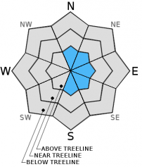
LOW avalanche danger will exist on all aspects below treeline for today.
MODERATE avalanche danger will exist on N-NE-E-SE-S facing slopes for wind slabs near and above treeline. Human triggered wind slab avalanches are possible today. Careful evaluation of the snowpack and terrain are neccessary.


Avalanche Problem 1: Wind Slab
-
Character ?

-
Aspect/Elevation ?
-
Likelihood ?CertainVery LikelyLikelyPossible
 Unlikely
 -
Size ?HistoricVery LargeLargeSmall

High West/Northwest winds that blew across the area with Monday's storm and continued through Wednesday have created wind slabs at near and above treeline areas. Warm temperatures Tuesday and Wednesday helped wind slabs that formed to settle and begin to bond with underlying snow. That being said, wind slabs will still be a concern on N-NE-E-SE-S aspects above treeline. Ridge tops will likely have been scoured by the high wind speeds down to firm/frozen snow. Below rigde top areas that are not typically wind slab starting zones could harbor wind slab formations. More Easterly facing aspects at above treeline elevations will have the best chance of hosting any wind slab formation. However, it should be noted that local orographics can create unusual wind eddies that can load other aspects. Use visual clues such as blowing snow, cornice formation, rounded and hollow sounding firm slabs, and cracking along ridge lines and extreme terrain to determine where wind slabs might exist. Wind slabs are often limited by terrain and usually have well defined boundaries. Cornices may have formed in isolated areas along ridge tops pointing toward the leeward side. Travel along the windward side of the ridge and steer clear of the ridge top. A common place to find cornices would be along the north ridge of Grey Butte or the ridge above Heart Lk. near Castle Lk.
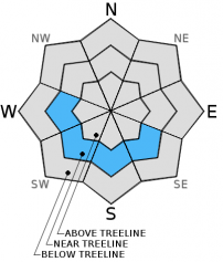
Avalanche Problem 2: Persistent Slab
-
Character ?

-
Aspect/Elevation ?
-
Likelihood ?CertainVery LikelyLikelyPossible
Unlikely
-
Size ?HistoricVery LargeLargeSmall
For the past week and a half we have been keeping a close eye on the PWL that formed around the crust layer that developed the second week of December. It is an avalanche problem that we do not typically see which makes it quite interesting to study. Multiple snow study pits dug by mutiple parties in the vicinity of Grey Butte and other areas where the PWL has been identified are in agreement that the partially faceted crystals within this layer are rounding and beginning to more readily bond. Stability tests in areas where the layer has been observed have shown strengthening of the snowpack with extended column test results showing the layer to be stubborn to trigger and no propagation. This leads me to believe that a human triggered avalanche of the PWL is unlikely. There is still a slight chance that a snowmobile high marking across, or a cluster of multiple people on a slope disturbing the right trigger point of shallow snow around a rock, stump, etc. could add enough stress to initiate fracture of said PWL. If this were to happen the consequences could be dire due to the amount of snow consolidated above the PWL. Careful evaluation of the snowpack and cautious route finding are still necessary. Pay attention to slope and terrain at all times and make your own decisions!
Forecast Discussion
Mostly cloudy to overcast skies in the early morning yesterday gave way to mostly sunny skies with a few scattered clouds by late morning offering up beautiful views of the snow covered mountains surrounding Mt. Shasta City. Wednesday was another break from stormy weather allowing the sun to have an influence on the snowpack. We did not recieve quite the amount of snow forecast for last nights storm with snow totals this morning of only 1-2 inches. Weather for today will call for scattered snow showers with the bulk of the precipitation tracking to the north of our area. Patches of blue sky are already visible, and any precip. amounts will be light. An upper level ridge and a surface high pressure will bring cold air and mostly sunny skies for Saturday and the beginning of Sunday before a weather disturbance approaches Sunday evening. An inversion will cause valley fog that could be dense in some areas (Shasta Valley) over the weekend. The storm system that will arrive late Sunday is forecast to be weaker than those experienced this week.
THIS SEASON PRECIPITATION: Since October 1st (the wet season), we have recieved 9.31 inches of water, normal is 13.15 inches, putting us at 70% of normal. For the month of December, we have received 7.28 inches of water, normal is 5.79 inches, putting us at 125% of normal. For the year of 2015 we've received 26.49 inches of water, normal is 41.15 inches, putting us at 64% of normal
Recent Observations
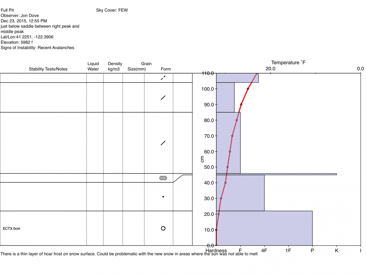
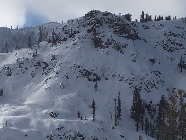
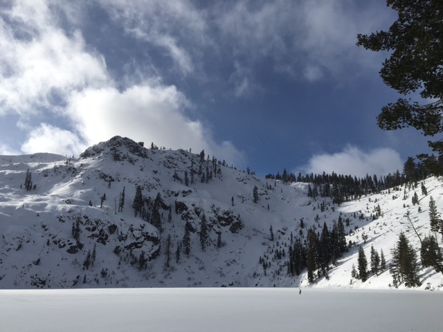
Snowpack observations made yesterday at Castle Lk. showed a variety of conditions depending on aspect. The southerly, more sun exposed aspect of Right Peak hosted a thick melt-freeze crust that was supportable 75% of the time. When you did break through every few turns it made for challenging skiing. In the more northerly, shaded aspects the snow was still soft. Is the lake frozen over? The lake IS frozen over, and the ice covering the lake was MOSTLY trustworthy. There ARE AREAS OF THIN ICE, especially around rocks that still protrude from the waters surface. Solar heating of the rock has prevented ice to fully form around them. I skinned along the edge of the lake, near the shore, to be safe. The cold temperatures over the next couple of days will help to better solidify the lake's surface. A snow study pit was dug and a full pit profile performed just below the saddle between Right Peak and the "Chutes" area below Middle Peak. Snow measured 110 cm deep on a NE aspect on a 25 degree slope. No obvious weaknesses were found amongst the layers and the PWL found elsewhere was non existent. An extended column test was performed multiple times with the same results, ECTX. It should also be noted that there was evidence of recent avalalanche activity off of the rock buttress above Castle Lk. It was loose dry snow point release avalanches in two locations (see photo below). The snowpack is still in early season condition with manzanita and some rocks still poking out. You can ski and ride up at Castle Lk. but be careful for shallow hidden objects.
Wind slabs are still a factor to consider. A naturally triggered wind slab avalanche was reported in Sun Bowl. Evidence was observed yesterday (Wednesday 23rd). Wind slabs that were formed during the storm on S-SE-E-NE-N aspects and may have grown due to continued high winds through Wednesday. Avoid travel over or under areas of possible wind slab formation, known avalnche paths, and run out zones. Ridge tops remain scoured down to firm/frozen snow. Small to medium size cornices may have formed on some ridge tops near treeline and may be easy to trigger. If traveling along a ridge where cornices have formed give them plenty of room. There is a slight chance that a cornice fall my trigger a wind slab avalanche on slopes underneath on leeward aspects. Easterly aspects have shown the best wind loading. Wind slabs are guaranteed above treeline, so over snow travel will call for careful route planning.
We've been keeping close tabs of the persistent weak layer problem digging snow study pits where the layer might exist, and continuing to conduct stability test in areas where we know the layer exists. While searching far and wide the PWL has not been found in any new areas. Stability tests performed in areas where the problem exists are showing results indicating a gradual strengthening as warmer temps and some sun shine have helped to melt and round the partially faceted crystals within the PWL. Has the added weight of heavy snow and the effect of warmer temperatures eliminated the hazard presented by this layer? Signs point toward the PWL becoming less and less of a problem. As stated above, the PWL was not present where the pit profile at Castle Lk. was performed, and reports from those who dug pits to test the PWL for the Mt. Shasta Ski Park Ski Patrol suggest strengthening and less concern as well.
12-23-2015 Pit Profile from Castle Lk. by Jon Dove:
Rock buttress above Castle lk. Natural loose dry point release avy just right of center of photo. Note avy debris from 2nd slide in bowl at lower left corner of photo: Jon Dove
________________________________________________________________________________________________________________________________________________________________________
The Sand Flat cross country ski trails are snow covered and ready for your cross country skis or snow shoes. These are backcountry trails marked with blue diamonds on trees. Trails are not groomed. Snow shoers, please blaze a parallel trail to cross country skiers staying out of the skin track. Thank you, and Enjoy!
The Pilgrim Creek Snowmobile Park is open! Trails are being groomed currently. Head to our "Education" tab on our website and find the snowmobile section for trail information, grooming status and other sledder resources!
The Five Red Flags of Avalanche Danger any time of year include: 1) Recent/current avalanche activity 2) Whumpfing sounds or shooting cracks 3) Recent/current heavy snowfall 4) Strong winds transporting snow 5) Rapid warming or rain on snow.
Weather and Current Conditions
Weather Summary
Good Morning! In Mt Shasta City at 0500, we have a current temperature of 29 F, mostly cloudy with light snow and calm winds.
MOUNTAIN WEATHER STATION INFORMATION (0500hrs):
On Mt Shasta (South Side) in the last 24 hours...
Old Ski Bowl - 7,600 feet, the current temperature is 14 degrees F. Snow on the ground totals 60 inches with 2 inches of new snow in the last 24 hours. Temperatures have ranged from 14 F to 20 F.
Grey Butte - 8,000 feet, the current temperature is 13 degrees F. Temperatures have ranged from 13 F to 17 F in the last 24 hours. Winds have been averaging 26 mph, NW in direction with a max gust to 71 mph, NW.
Mt Eddy Range (West side of Interstate-5)...
Castle Lake - 5,600 feet, the current temperature is 20 degrees F. Temperatures have ranged from 20 F to 29 F in the last 24 hours. Snow on the ground measures 32 inches with a trace of new snow, and 2 inches of settlement.
Mt Eddy - 6,500 feet, the current temperature is 17 degrees F. Temperatures have ranged from 17 F to 23 F. Snow on the ground measures about 52 inches with 2 inches of new snow in the last 24 hours and no settlement. Winds have averaged 2 mph, with a max gust to 11 mph, ESE.
Always check the weather before you attempt to climb Mt Shasta. Further, monitor the weather as you climb. Becoming caught on the mountain in any type of weather can compromise life and limb. Be prepared.
| 0600 temperature: | 19 |
| Max. temperature in the last 24 hours: | 23 |
| Average wind direction during the last 24 hours: | Northwest |
| Average wind speed during the last 24 hours: | 26 mi/hr |
| Maximum wind gust in the last 24 hours: | 71 mi/hr |
| New snowfall in the last 24 hours: | 2 inches |
| Total snow depth: | 60 inches |
Two Day Mountain Weather Forecast
Produced in partnership with the Medford NWS
| For 7000 ft to 9000 ft | |||
|---|---|---|---|
|
Thursday (4 a.m. to 10 p.m.) |
Thursday Night (10 p.m. to 4 a.m.) |
Friday (4 a.m. to 10 p.m.) |
|
| Weather | Mostly cloudy, snow showers. Wind chill values as low as - | Mostly cloudy with a 40% chance of snow showers. Wind chill values as low as -5 | Partly sunny with a 30% chance of snow showers. |
| Temperature (°F) | 18 | 10 | 21 |
| Wind (mi/hr) | West 5-10 mph | Northwest 6-10 mph with gusts to 20 mph | Northwest 5-10 mph |
| Precipitation SWE / Snowfall (in) | / 3-5 | / 1-2 | / 0 |
| For 9000 ft to 11000 ft | |||
| Thursday | Thursday Night | Friday | |
| Weather | Mostly cloudy with snow showers. Wind chill values as low as -19 | Mostly cloudy with 40% chance snow showers. Wind chill values as low as -19 | Partly sunny with a 30% chance of snow showers. Wind chill values as low as -20 |
| Temperature (°F) | 3 | 2 | 2 |
| Wind (mi/hr) | West/northwest 10-15 mph with gusts to 20 mph | Northwest 4-8 | Northwest 10-15 mph with gusts to 20 mph |
| Precipitation SWE / Snowfall (in) | / 4-8 | / 1-3 | / 0 |

