

You are here
Avalanche Advisory for 2015-12-26 06:33:51
- EXPIRED ON December 27, 2015 @ 6:33 amPublished on December 26, 2015 @ 6:33 am
- Issued by Nick Meyers - Shasta-Trinity National Forest
Bottom Line
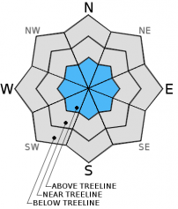
Wind slabs represent the main avalanche problem in the forecast area today. Overall, LOW avalanche danger will exist on all aspects below and near treeline
Above treeline, overall MODERATE avalanche danger will exist on all aspects for slopes steeper than 35 degrees. Small to large wind slabs are possible and could be triggered by a single rider or skier and involve enough snow to bury a person.


Avalanche Problem 1: Wind Slab
-
Character ?

-
Aspect/Elevation ?
-
Likelihood ?CertainVery LikelyLikelyPossible
 Unlikely
 -
Size ?HistoricVery LargeLargeSmall

Overall, uncertainty exists regarding wind slab stability. Small to large wind slabs sitting on icy crusts with consistent cold temperatures leads me to believe that they could still be sensitive to trigger. Strong West/Northwest winds blew across the forecast area over the week and have created wind slabs mostly above treeline and primarily on NE-E-SE aspects. You'll notice however that we've highlighted all aspects on the danger rose. It's from our experience that while yes, west/northwest winds would classically load E-SE aspects, we often find other aspects wind loaded also. The best wind loading and largest slabs will be found on east and southeast slopes, but don't let your guard down when travelling on other aspects. Ridge tops are scoured down to firm/frozen snow. Below ridge top's, not typically wind slab starting zones, could host the best wind slab formations due to high wind speeds. Use visual clues such as blowing snow, cornice formation, rounded and hollow sounding firm slabs, and cracking along ridge lines and extreme terrain to determine where wind slabs might exist. Wind slabs are often limited by terrain and usually have well defined boundaries. Cornices may have formed in isolated areas along ridge tops pointing toward the leeward side. Travel along the windward side of the ridge and steer clear of the ridge top. A common place to find cornices is along Casaval Ridge, the north ridge of Grey Butte or the ridge above Heart Lake/Castle Lake.
Forecast Discussion
Clear and sunny skies for the day after Christmas! The weather is going to be crisp, cool and likely gorgeous today and we encourage everybody to get up, get outside and get some fresh air! I think I can safely assume and also speak for myself by saying we have some spare calories ingested over the past few days to burn off. Enjoy the day! A high pressure ridge rides over the area currently. Of most interest is a small incoming storm set to arrive later on Sunday bringing light snowfall to the area with snow levels down to 2,000 feet. This short lived storm will freshen up the snow surface and we should see a couple inches on the mountain. By Monday afternoon, skies will clear. Looking even further into the future, another small storm is expected for late Tuesday and is similar to the Sunday/Monday storm. Confidence is low for this storm currently and we'll keep you posted for that one. All that aside, let's live for today and enjoy the bluebird skies upon us!
THIS SEASON PRECIPITATION: Since October 1st (the wet season), we have recieved 9.34 inches of water, normal is 13.67 inches, putting us at 68% of normal. For the month of December, we have received 7.31 inches of water, normal is 6.31 inches, putting us at 115% of normal. For the year of 2015 we've received 26.52 inches of water, normal is 41.67 inches, putting us at 63% of normal
Recent Observations
Yesterday, a Mt Shasta Ski Park employee noted he saw "large chunks of snow and some darker chunks also mixed in" in the Old Ski Bowl area. We were never able to get a close look however either rockfall, a cornice break or a wind slab avalanche sounded likely.
Wind slabs continue to be the main avalanche problem. Trepidation is steaming this morning because of a few things: Icy crusts, new snow, windy conditions over the week, consistently cold temps above treeline. These factors point toward potentially sensitive, small to large wind slab avalanches. Use caution above treeline, especially on south and easterly aspects.
Castle Lake skiing is in the picture now. A couple small, loose dry point release slides occured a few days ago, though overall the snowpack remains shallow up there. The lake is mostly frozen. Mixed snow conditions with pockets of breakable crust was observed on the 23rd.
Skiing on the mountain is also a bit mixed. Great, light density snow is prominent above 7,500 feet though variable crust layers, some supportive and some not are present below our 4-6 inches of newer snow.
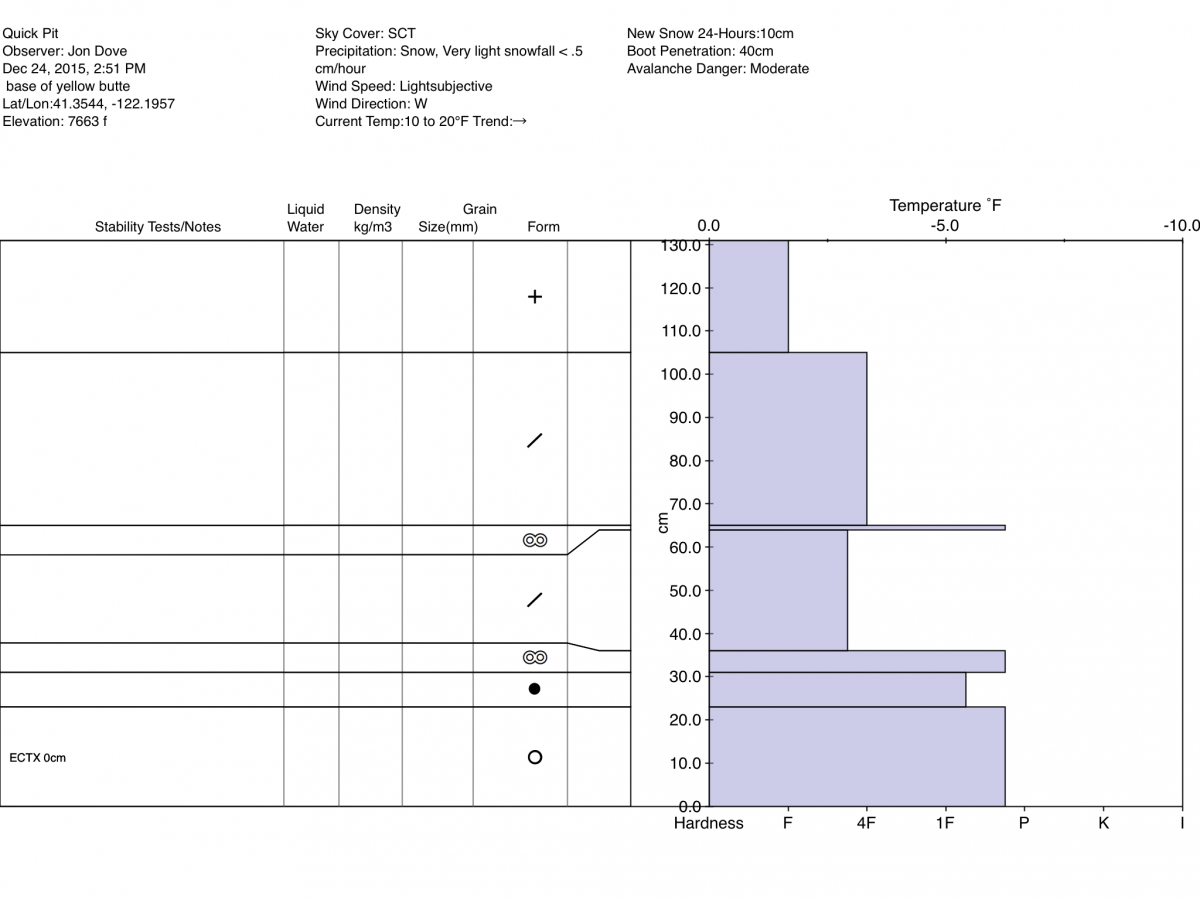
Below: Yellow Butte pit from Mt Shasta, 12.24.15
-------------------------------------------------------------------------------------------------------------------------------
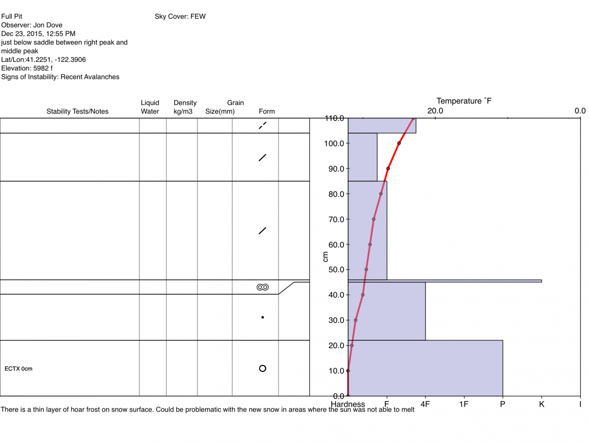
Below: Castle Lake pit, 12.23.15
________________________________________________________________________________________________________________________________________________________________________
The Sand Flat cross country ski trails are snow covered and ready for your cross country skis or snow shoes. These are backcountry trails marked with blue diamonds on trees. Trails are not groomed. Snow shoers, please blaze a parallel trail to cross country skiers staying out of the skin track. Thank you, and Enjoy!
The Pilgrim Creek Snowmobile Park is open! Trails are being groomed currently. Head to our "Education" tab on our website and find the snowmobile section for trail information, grooming status and other sledder resources!
The Five Red Flags of Avalanche Danger any time of year include: 1) Recent/current avalanche activity 2) Whumpfing sounds or shooting cracks 3) Recent/current heavy snowfall 4) Strong winds transporting snow 5) Rapid warming or rain on snow.
Weather and Current Conditions
Weather Summary
Good Morning! In Mt Shasta City at 0500, we have a current temperature of 18 F and mostly clear skies.
MOUNTAIN WEATHER STATION INFORMATION (0500hrs):
On Mt Shasta (South Side) in the last 24 hours...
Old Ski Bowl - 7,600 feet, the current temperature is 9 degrees F. Snow on the ground totals 60 inches with no new snow and 4 inches settlement. Temperatures have ranged from 7 F to 19 F.
Grey Butte - 8,000 feet, the current temperature is 9 degrees F. Temperatures have ranged from 9 F to 21 F. Winds have been averaging 5 mph and variable in direction, with a max gust to 42 mph out of the NW.
Mt Eddy Range (West side of Interstate-5)...
Castle Lake - 5,600 feet, the current temperature is 14 degrees F. Temperatures have ranged from 14 F to 24 F. Snow on the ground measures 33 inches with no new snow and little settlement.
Mt Eddy - 6,500 feet, the current temperature is 9 degrees F. Temperatures have ranged from 8 F to 20 F. Snow on the ground measures 49 inches with no new snow and 2 inches settlement. Winds have averaged 2 mph, with a max gust to 11 mph, ESE.
Always check the weather before you attempt to climb Mt Shasta. Further, monitor the weather as you climb. Becoming caught on the mountain in any type of weather can compromise life and limb. Be prepared.
| 0600 temperature: | 5 |
| Max. temperature in the last 24 hours: | 21 |
| Average wind direction during the last 24 hours: | Variable |
| Average wind speed during the last 24 hours: | 5-10 mi/hr |
| Maximum wind gust in the last 24 hours: | 42 mi/hr |
| New snowfall in the last 24 hours: | 0 inches |
| Total snow depth: | 60 inches |
Two Day Mountain Weather Forecast
Produced in partnership with the Medford NWS
| For 7000 ft to 9000 ft | |||
|---|---|---|---|
|
Saturday (4 a.m. to 10 p.m.) |
Saturday Night (10 p.m. to 4 a.m.) |
Sunday (4 a.m. to 10 p.m.) |
|
| Weather | Sunny | Partly cloudy | Chance of snow between 10am and 4pm, then showers after 4pm. |
| Temperature (°F) | 31 | 17 | 28 |
| Wind (mi/hr) | East 5-10 mph | Southeast 5-10 mph | South 10-15 mph |
| Precipitation SWE / Snowfall (in) | / 0 | / 0 | / 1 |
| For 9000 ft to 11000 ft | |||
| Saturday | Saturday Night | Sunday | |
| Weather | Sunny | Partly cloudy | Chance of snow between 10am and 4pm, then snow showers after 4pm |
| Temperature (°F) | 28 | 25 | 20 |
| Wind (mi/hr) | North/Northeast 20-30 mph | Southwest 0 | West/Southwest 5-15 mph |
| Precipitation SWE / Snowfall (in) | / 0 | / 0 | / 1-2 |

