

You are here
Avalanche Advisory for 2015-12-27 06:50:22
- EXPIRED ON December 28, 2015 @ 6:50 amPublished on December 27, 2015 @ 6:50 am
- Issued by Nick Meyers - Shasta-Trinity National Forest
Bottom Line
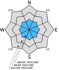
Above treeline, continue to expect isolated pockets of MODERATE avalanche danger for small to medium size wind slabs on slopes steeper than 35 degrees in extreme/complex terrain and narrow couloirs. Small to medium size wind slabs could be triggered by a single rider or skier and involve enough snow to bury a person or sweep one into undesireable terrain.
Overall, LOW avalanche danger will exist on all aspects, all elevations today.


Avalanche Problem 1: Wind Slab
-
Character ?

-
Aspect/Elevation ?
-
Likelihood ?CertainVery LikelyLikelyPossible
 Unlikely
 -
Size ?HistoricVery LargeLargeSmall

The greatest concern for today continues to be small to medium sized wind slab avalanches that could be triggered by a single human or rider. Round sculpted snow shaped into pillow like formations one to three feet deep dot the forecast area. Wind slabs will be most sensitive to trigger on slopes greater than 35 degrees and specifically in extreme terrain, rocky outcrops and couloirs. Even a small wind slab could easily sweep one into undesirable terrain, over a cliff, into trees, etc. Size does not matter. All ridgelines on Mt Shasta are scoured down to firm, icy crust. Gully bottoms and gully flanks (mid-slope areas) hold the best wind deposited snow and is the best place to find wind slabs. Expect all aspects above treeline to hold some form a wind deposited snow due to variable winds over the past week.
Forecast Discussion
Temperatures yesterday morning were brisk! Distinct contrast was felt from AM to PM. A chilly morning unfolded into a crisp, beautiful day and by evening warmer air was felt in the area. But, for every up there is a down! Today - a cold front pushes back into the area as a weak low pressure system sweeps Northern California. The majority of this westerly tracking storm will pass to the north of Mt Shasta. Coastal mountans will get the brunt of the water and the Siskiyous will get the leftovers. Crater Lake is expected to receive .35 inches of water, Mt Shasta .20 inches over the next 24-36 hours. The heaviest precip will fall late today and tonight and we will see at least a dusting, if not several inches of fresh snow above Bunny Flat (6,950 ft.). Snow levels will start at 4,500 to 5,000 feet and drop to near 1,500 to 2,000 feet by tonight. Winds will blow primarily out of the west/northwest,10-20 mph. By Monday afternoon, a few lingering snow showers may still pass though, however clearing skies will trend into Tuesday. Another small system, similar to this first one, sits on deck for Tuesday night and Wednesday.
THIS SEASON PRECIPITATION: Since October 1st (the wet season), we have recieved 9.34 inches of water, normal is 13.93 inches, putting us at 67% of normal. For the month of December, we have received 7.31 inches of water, normal is 6.57 inches, putting us at 111% of normal. For the year of 2015 we've received 26.52 inches of water, normal is 41.93 inches, putting us at 63% of normal
Recent Observations
Blue sky and sunshine were out in full force yesterday. The morning started out downright chilly. With the wind chill factor, superficial frostbite was certainly possible on exposed cheeks and ear lobes. We havn't had to bundle up like that in years! Temeratures did warm throughout the day and southerly facing slopes below approximately 7,700 feet took a bit of a hit. Four inches of settlement in the snowpack occured at the Old Ski Bowl station and a sun crust will likely be found today on the surface of the snow on lower elevation, sunny aspects. The warming temperatures have aided in stabilizing the snowpack and recent avalanches are/or instability are far and few between.
Skiing has been very good in certain areas with some of the lightest density snow Shastafarians have skied in a long time.... locally that is. These areas of great snow seem to be lower to mid elevation northerly and/or shady aspects or, most aspects mid to upper elevations... granted you don't find completely scoured, wind buffed, icy exposed areas. Any portion of terrain above treeline that is not a gully is wind packed powder or icy, old snow. Protected, lower lying gullies have amazing, light snow fluffed in and holds the best skiing. The cold, clear nights of recent days has formed some surface hoar in low lying areas. Not a threat now, though zones that receive the most new snow on top of preserved surface hoar may be reason to consider raising the avalanche danger in the coming days. That said, preserved surface hoar almost always gets destroyed by wind in our best producing avalanche terrain above treeline.
Snowpit data and stability tests have all indicated a strong snowpack overall. However, very small wind slabs on test slopes have been easily triggerable in extreme terrain on slopes steeper than 35 degrees. Easterly aspects are holding the largest wind slabs and although "small" in the grand scheme of things, one of these small wind slab could still be enough to sweep one off their feet and into undesirable terrain. So, continue to be careful when treading on unpredictable wind slabs. Mid and upper mountain observations are limited and wind slabs that have formed on icy crusts should be one's biggest concern today.
Castle Lake skiing is in the picture now. The lake is mostly frozen. Mixed snow conditions with pockets of breakable crust have been observed. We have limited observations from the Castle Lake area. A still shallow snowpack is keeping most folks shredding on the mountain or at the Ski Park!
________________________________________________________________________________________________________________________________________________________________________
The Sand Flat cross country ski trails are snow covered and ready for your cross country skis or snow shoes. These are backcountry trails marked with blue diamonds on trees. Trails are not groomed. Snow shoers, please blaze a parallel trail to cross country skiers staying out of the skin track. Thank you, and Enjoy!
The Pilgrim Creek Snowmobile Park is open! Trails are being groomed currently. Head to our "Education" tab on our website and find the snowmobile section for trail information, grooming status and other sledder resources!
The Five Red Flags of Avalanche Danger any time of year include: 1) Recent/current avalanche activity 2) Whumpfing sounds or shooting cracks 3) Recent/current heavy snowfall 4) Strong winds transporting snow 5) Rapid warming or rain on snow.
Weather and Current Conditions
Weather Summary
Good Morning! In Mt Shasta City at 0500, we have a current temperature of 27 F and cloudy clear skies.
MOUNTAIN WEATHER STATION INFORMATION (0500hrs):
On Mt Shasta (South Side) in the last 24 hours...
Old Ski Bowl - 7,600 feet, the current temperature is 31 degrees F. Snow on the ground totals 56 inches with no new snow and 4 inches settlement. Temperatures have ranged from 11 F to 37 F.
Grey Butte - 8,000 feet, the current temperature is 29 degrees F. Temperatures have ranged from 12 F to 36 F. Winds have been averaging 10 mph primarily from the WNW, with a max gust to 28 mph out of the WNW and also the ENE.
Mt Eddy Range (West side of Interstate-5)...
Castle Lake - 5,600 feet, the current temperature is 23 degrees F. Temperatures have ranged from 14 F to 25 F. Snow on the ground measures 31 inches with no new snow and 2 inches settlement.
Mt Eddy - 6,500 feet, the current temperature is 30 degrees F. Temperatures have ranged from 10 F to 31 F. Snow on the ground measures 47 inches with no new snow and 2 inches settlement. Winds have averaged 2 mph, with a max gust to 12 mph, WSW.
Always check the weather before you attempt to climb Mt Shasta. Further, monitor the weather as you climb. Becoming caught on the mountain in any type of weather can compromise life and limb. Be prepared.
| 0600 temperature: | 5 |
| Max. temperature in the last 24 hours: | 21 |
| Average wind direction during the last 24 hours: | Variable |
| Average wind speed during the last 24 hours: | 5-10 mi/hr |
| Maximum wind gust in the last 24 hours: | 42 mi/hr |
| New snowfall in the last 24 hours: | 0 inches |
| Total snow depth: | 60 inches |
Two Day Mountain Weather Forecast
Produced in partnership with the Medford NWS
| For 7000 ft to 9000 ft | |||
|---|---|---|---|
|
Sunday (4 a.m. to 10 p.m.) |
Sunday Night (10 p.m. to 4 a.m.) |
Monday (4 a.m. to 10 p.m.) |
|
| Weather | Snow likely after 10am | Snow showers | Chance of showers in the morning, partly cloudy. |
| Temperature (°F) | 28 | 18 | 26 |
| Wind (mi/hr) | East/Southeast becoming south 5-10 mph | South/Southeast becoming northwest after midnight 5-10 mph | North/Northwest 10-15 mph |
| Precipitation SWE / Snowfall (in) | / 1-2 | / 2-4 | / 0-.5 |
| For 9000 ft to 11000 ft | |||
| Sunday | Sunday Night | Monday | |
| Weather | Snow likely after 10am, mostly cloudy | Snow showers | Chance of snow showers, partly sunny and cold |
| Temperature (°F) | 20 and falling | 9 | 8 |
| Wind (mi/hr) | West/Southwest 25-35 mph | West/Northwest 1-3 | North 15-25 moh |
| Precipitation SWE / Snowfall (in) | / 1-3 | / 3-5 | / 0-.5 |

