

You are here
Avalanche Advisory for 2015-12-28 06:40:05
- EXPIRED ON December 29, 2015 @ 6:40 amPublished on December 28, 2015 @ 6:40 am
- Issued by Nick Meyers - Shasta-Trinity National Forest
Bottom Line
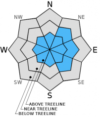
Above treeline, expect isolated pockets of MODERATE avalanche danger for small to medium size wind slabs on NE-E-SE slopes steeper than 35 degrees in extreme/complex terrain and narrow couloirs. We've received 1-3 inches of new snow in the last 24 hours with WNW winds averaging 10-20 mph. Small to medium size wind slabs could be triggered and involve enough snow to bury a person.
Overall, LOW avalanche danger will exist on all aspects and elevations today.


Avalanche Problem 1: Wind Slab
-
Character ?

-
Aspect/Elevation ?
-
Likelihood ?CertainVery LikelyLikelyPossible
 Unlikely
 -
Size ?HistoricVery LargeLargeSmall

The greatest concern for today continues to be small to medium sized wind slabs that could be triggered by a single human or rider. Shooting cracks and small slabs have been easily triggered on test slopes in recent days. Slab density can vary drastically depending on wind speed, temperature and snow crystal type. As these factors change, so will the wind slab character. We found harder, wind packed snow on top of much lighter density snow yesterday and this formed the weak layer in the Mt Eddy range. Slabs were 6-12 inches deep though could be much deeper. Round sculpted snow shaped into pillow like formations dot the forecast area. Wind slabs will be most sensitive to trigger on slopes greater than 35 degrees and specifically in extreme terrain, rocky outcrops and couloirs. Even a small wind slab could easily sweep one into undesirable terrain, over a cliff, into trees, etc. Size does not matter. All ridgelines on Mt Shasta are scoured down to firm, icy crust. All that snow has to go somewhere! During high wind events, snow will load in mid-slope areas far below normal start zones. Even during LOW avalanche danger, keep your awareness up as you can quickly ski onto an isolated wind slab and take a ride!
Forecast Discussion
Greetings! Hoping you had a great Christmas and are perhaps gearing up for New Years! December has been a great month for precipitation with water totals above normal. It's our hope that the slow trickle of winter weather continues! Yesterday, the incoming cold front swept primarily north of Mt Shasta however we did get brushed and dusted with a few inches of new snow on the mountain and a skiff here in town. Scattered showers and cool temperatures will linger today. Gradual clearing this afternoon and tonight will be short lived as another system, very similar to this current one, will move through bringing more of the same on Tuesday night/Wednesday. We'll see another refresher with 1-2 inches of light density snow on the mountain. Wind in the area will be light below and near treeline, northerly 5-10 mph. Above treeline, things will be a little different with North/Northwest wind blowing 20-30 mph, most noticable on exposed ridgelines and terrain funnels.
THIS SEASON PRECIPITATION: Since October 1st (the wet season), we have recieved 9.34 inches of water, normal is 14.19 inches, putting us at 65% of normal. For the month of December, we have received 7.31 inches of water, normal is 6.83 inches, putting us at 107% of normal. For the year of 2015 we've received 26.52 inches of water, normal is 42.19 inches, putting us at 62% of normal
Recent Observations
We have three main scenarios right now in forecast area. Let's cut right to the chase: For the best skiing and riding conditions, northerly shaded aspects are still holding dry, smooth powder from about 7,000 feet to treeline. That is one scenario. We've observed a few southerly aspects hosting light density powder granted in the shade, though most southerly aspects below 8,000 feet exposed to sun have formed a sun crust at/near the surface of the snow. The crust trends on the thinner, zipper crust side of things which if we were forced to ski on crust, this would be preferable... opposed to the ankle breaking stuff. This is our second scenario: thin crust on sunny, southerly aspects. Lastly and our third scenario is our always present wind blown, hard, icy crust/old snow. One can guess where to find that: exposed ridgelines above treeline and pretty much all geographic forms that stick up and out! While much of the above treeline terrain is wind affected, low lying areas such as Avalanche Gulch or Giddy Giddy (both gullies) are collecting some nice powder and providing some nice lines for folks. Remember that gully riding can be fun and host great snow when the avalanche danger is LOW. When the avalanche danger is higher, gullies are a poor choice of terrain to ski and ride as they act as terrain traps for avalanches and can also funnel large avalanche from above directly toward/on you.
The meat and taters of our on snow observations are skimpy... that is, our observations have not raised our eyebrows very much. We started out the year with the exciting (for an avalanche forecaster) persistent weak layer, though that problem has subsided. We've had cool temperatures trending for much of the month with a few brief warm up's. Snowpit data and stability tests have indicated a strong snowpack. Day to day wind slab formation and variable wind slab sensitivity will continue as the main hazard in the backcountry right now. Yesterday, small shooting cracks were easily caused on a westerly facing ridgeline in the Mt Eddy range. On Mt Shasta near treeline in the Sun Bowl area, a couple ECT tests gave no results on a South/Southeast facing slope (ECTX). Small, isolated wind slabs continue to be easily triggerable with weak layers posing as density changes in the slab. The wind slabs triggered were all on small test slopes. Slabs of larger consequence are possible out there and it will be important to be able to identify wind slabs and stay off of them above treeline.
Castle Lake skiing is in the picture now. The lake is mostly frozen. Mixed snow conditions with pockets of breakable crust have been observed. We have limited observations from the Castle Lake area. A still shallow snowpack is keeping most folks shredding on the mountain or at the Ski Park!
The Mt Eddy area via Parks Creek Road is hosting a decent snowpack with similar skiing conditions as described above. One can drive up Parks Creek Road a couple miles before deeper snow is encountered and either a snowmobile or several mile skin in is required.
________________________________________________________________________________________________________________________________________________________________________
The Sand Flat cross country ski trails are in great shape and ready for your cross country skis or snow shoes. These are backcountry trails marked with blue diamonds on trees. Trails are not groomed. Snow shoers, please blaze a parallel trail to cross country skiers staying out of the skin track. Thank you, and enjoy!
The Pilgrim Creek Snowmobile Park is open! Trails are being groomed currently. Head to our "Education" tab on our website and find the snowmobile section for trail information, grooming status and other sledder resources!
The Five Red Flags of Avalanche Danger any time of year include: 1) Recent/current avalanche activity 2) Whumpfing sounds or shooting cracks 3) Recent/current heavy snowfall 4) Strong winds transporting snow 5) Rapid warming or rain on snow.
Weather and Current Conditions
Weather Summary
Good Morning! In Mt Shasta City at 0500, we have a current temperature of 28 F, one degree warmer than yesterday at this time and obscured skies with light snow falling.
MOUNTAIN WEATHER STATION INFORMATION (0500hrs):
On Mt Shasta (South Side) in the last 24 hours...
Old Ski Bowl - 7,600 feet, the current temperature is 19 degrees F. Snow on the ground totals 57 inches with 1-2 inches new snow and 3 inches settlement. Temperatures have ranged from 13 F to 29 F.
Grey Butte - 8,000 feet, the current temperature is 18 degrees F. Temperatures have ranged from 12 F to 29 F. Winds have been averaging 15 mph primarily from the WNW, with a max gust to 35 mph out of the WNW.
Mt Eddy Range (West side of Interstate-5)...
Castle Lake - 5,600 feet, the current temperature is 19 degrees F. Temperatures have ranged from 18 F to 29 F. Snow on the ground measures 31 inches with 1-2 inches new snow and 1-2 inches settlement.
Mt Eddy - 6,500 feet, the current temperature is 21 degrees F. Temperatures have ranged from 19 F to 35 F. Snow on the ground measures 47 inches with 1-2 inches new snow and 1 inch settlement. Winds have averaged 1 mph and southerly in direction, with a max gust to 9 mph, East.
Always check the weather before you attempt to climb Mt Shasta. Further, monitor the weather as you climb. Becoming caught on the mountain in any type of weather can compromise life and limb. Be prepared.
| 0600 temperature: | 21 |
| Max. temperature in the last 24 hours: | 26 |
| Average wind direction during the last 24 hours: | Northwest |
| Average wind speed during the last 24 hours: | 15 mi/hr |
| Maximum wind gust in the last 24 hours: | 35 mi/hr |
| New snowfall in the last 24 hours: | 1-3 inches |
| Total snow depth: | 57 inches |
Two Day Mountain Weather Forecast
Produced in partnership with the Medford NWS
| For 7000 ft to 9000 ft | |||
|---|---|---|---|
|
Monday (4 a.m. to 10 p.m.) |
Monday Night (10 p.m. to 4 a.m.) |
Tuesday (4 a.m. to 10 p.m.) |
|
| Weather | Scattered showers, partly sunny | Partly cloudy | Mostly sunny |
| Temperature (°F) | 26 | 14 | 29 |
| Wind (mi/hr) | North/Northwest 10-15 mph | North 10-15 mph | North 10-15 mph |
| Precipitation SWE / Snowfall (in) | / 0-.5 | / 0 | / 0 |
| For 9000 ft to 11000 ft | |||
| Monday | Monday Night | Tuesday | |
| Weather | Scattered snow showers, partly sunny | Partly cloudy | Mostly sunny |
| Temperature (°F) | 8 | 8 | 14 |
| Wind (mi/hr) | North/Northwest 25-35 mph | North 0-.5 | Northwest 40-50 mph |
| Precipitation SWE / Snowfall (in) | / 0-.5 | / 0 | / 0 |

