

You are here
Avalanche Advisory for 2015-12-29 06:34:51
- EXPIRED ON December 30, 2015 @ 6:34 amPublished on December 29, 2015 @ 6:34 am
- Issued by Nick Meyers - Shasta-Trinity National Forest
Bottom Line
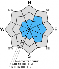
Overall, LOW avalanche danger will exist on all aspects and elevations today.
Very isolated areas hosting small wind slabs are still possible on leeward NE-E-SE slopes above treeline though not expected to present a significant hazard to backcountry travel IF normal caution is applied.


Avalanche Problem 1: Wind Slab
-
Character ?

-
Aspect/Elevation ?
-
Likelihood ?CertainVery LikelyLikelyPossible
 Unlikely
 -
Size ?HistoricVery LargeLargeSmall

Wind slabs are not expected to host a major hazard to backcountry recreation today granted normal caution is exercised. A couple inches of snow and northwest winds over the week may form some very small wind slabs only in areas where conditions are perfect. New wind slabs will be small and shallow with poor development on a full slope scale.
What is "Normal Caution"? Here are a few tips:
-Expose only one person at a time to avalanche terrain, skinning up AND riding down.
-Travel from one safe zone to another. Is your "safe zone" really safe should a slide occur?
-Avoid traveling above terrain traps
-Don't group up in avalanche run out zones
-SPEAK UP! Call out your partner if you observe poor decision making.
Forecast Discussion
Cold temperatures, uncharacteristic for the area in recent years, are keeping the snowpack mostly fresh and light. It's been a great two week line up of storms and resulting in consistent skiing and riding. We saw several inches of new snow from the recent storm beginning this week, and we'll see another very similar storm tonight. This short lived occluded front will swing through late today, give us most of it's precip tonight and begin to clear tomorrow. Water amounts will be less than the first storm, totalling somewhere near .08 to .10 inches, translating into 1-3 inches of new snow in the mountains of the forecast area. Snow levels will be low, 1,500 to 2,000 feet. Mt Shasta City will see a skiff of snow. Northwest winds will prevail above treeline, nothing major, though enough to blow some snow around. Expect exposed areas to host 20-30 mph winds and the upper mountain to see 40+ mph wind. Below and near treeline, wind will be more reasonable, 10-20 mph. After this small storm, things will clear a bit, but not for long. Climate prediction indicates below normal temps and above normal precip for the next 6-10 days. Next week, January 5/6, represents the next best chance of winter weather. No predictions on that quite yet, but enough of a stoke to keep the juices flowing!
THIS SEASON PRECIPITATION: Since October 1st (the wet season), we have recieved 9.40 inches of water, normal is 14.45 inches, putting us at 65% of normal. For the month of December, we have received 7.37 inches of water, normal is 7.09 inches, putting us at 103% of normal. For the year of 2015 we've received 26.58 inches of water, normal is 42.45 inches, putting us at 62% of normal
Recent Observations
Observations over the forecast area have not revealed any noteworthy signs of instability. Over the week, we've visited locations on Mt Shasta, Ash Creek Butte, Castle Lake, Mt Eddy and Cliff Lake. Below and near treeline, southerly aspects host a crust of variable depths and thickness with some shaded areas still holding powder. Above treeline, southerly facing, wind blown-icy ridges prevail with softer snow and wind packed powder in the gullies. Northerly aspects below and near treeline are still skiing and riding great. Consistent cold temperatures have kept our snow amazingly light and fluffy on these colder aspects. These soft powdery conditions have most locals grinning widely as our melt/freeze and crust skiing skills have superseded our powder riding skills due to poor winters past.
The persistent weak layer problem has subsided in case somebody missed that discussion. The wind slab avalanche problem could probably always be up on the advisory as Mt Shasta is a big mountain sticking up into the atmosphere and always receiving wind. That said, potentially dangerous wind slabs have been far and few between. We've been able to trigger very small slabs off ridgelines and bowls in steep, complex terrain but these small slabs have been insignificant. Our thought was that larger, more dangerous slabs could still exist in very isolated areas above treeline in narrow cross-loaded couloirs, rocky outcrops with leeward depressions and steep areas that are able to catch snow... but we still havn't seen much evidence of this. So, yes they still could exist, however where most people are riding and sliding, concerns are minimal. A few inches of new snow over the week will create snow available for transport but not expected to create any problems. Normal caution is advised, keep your eyes peeled for a rogue wind slab and continue to use safe travel practices. Just because the avalanche danger is LOW does not mean you should let your hair down and put on your rave glasses.
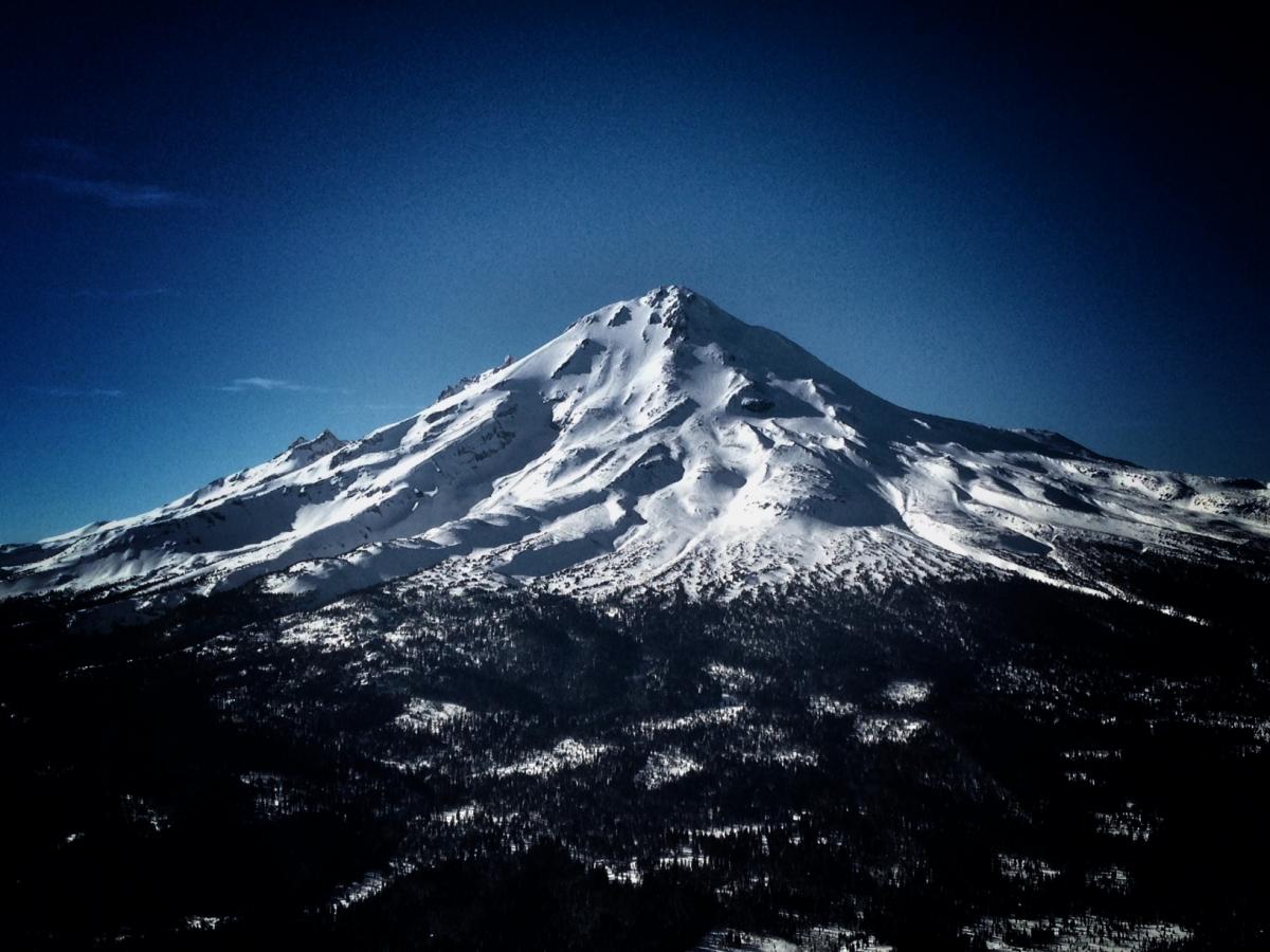
Mt Shasta viewed from Ash Creek Butte, 12/26/15. Photo: N Meyers
________________________________________________________________________________________________________________________________________________________________________
The Sand Flat cross country ski trails are in great shape and ready for your cross country skis or snow shoes. These are backcountry trails marked with blue diamonds on trees. Trails are not groomed. Snow shoers, please blaze a parallel trail to cross country skiers staying out of the skin track. Thank you, and enjoy!
The Pilgrim Creek Snowmobile Park is open! Trails are being groomed currently. Head to our "Education" tab on our website and find the snowmobile section for trail information, grooming status and other sledder resources!
The Five Red Flags of Avalanche Danger any time of year include: 1) Recent/current avalanche activity 2) Whumpfing sounds or shooting cracks 3) Recent/current heavy snowfall 4) Strong winds transporting snow 5) Rapid warming or rain on snow.
Weather and Current Conditions
Weather Summary
Good Morning! In Mt Shasta City at 0500, we have a current temperature of 23 F, five degrees colder than yesterday at this time, with mostly clear skies.
MOUNTAIN WEATHER STATION INFORMATION (0500hrs):
On Mt Shasta (South Side) in the last 24 hours...
Old Ski Bowl - 7,600 feet, the current temperature is 13 degrees F. Snow on the ground totals 57 inches with no new snow and 2 inches settlement. Temperatures have ranged from 10 F to 26 F.
Grey Butte - 8,000 feet, the current temperature is 14 degrees F. Temperatures have ranged from 12 F to 21 F. Winds have been averaging 5 mph and variable in direction, with a max gust to 28 mph out of the NW.
Mt Eddy Range (West side of Interstate-5)...
Castle Lake - 5,600 feet, the current temperature is 18 degrees F. Temperatures have ranged from 17 F to 26 F. Snow on the ground measures 31 inches with no new snow and little settlement.
Mt Eddy - 6,500 feet, the current temperature is 14 degrees F. Temperatures have ranged from 14 F to 23 F. Snow on the ground measures 46 inches with no new snow and 1 inch settlement. Winds have averaged 3 mph and southerly in direction, with a max gust to 14 mph, SSE.
Always check the weather before you attempt to climb Mt Shasta. Further, monitor the weather as you climb. Becoming caught on the mountain in any type of weather can compromise life and limb. Be prepared.
| 0600 temperature: | 6 |
| Max. temperature in the last 24 hours: | 28 |
| Average wind direction during the last 24 hours: | Variable |
| Average wind speed during the last 24 hours: | 0-10 mi/hr |
| Maximum wind gust in the last 24 hours: | 28 mi/hr |
| New snowfall in the last 24 hours: | .5-1 inches |
| Total snow depth: | 57 inches |
Two Day Mountain Weather Forecast
Produced in partnership with the Medford NWS
| For 7000 ft to 9000 ft | |||
|---|---|---|---|
|
Tuesday (4 a.m. to 10 p.m.) |
Tuesday Night (10 p.m. to 4 a.m.) |
Wednesday (4 a.m. to 10 p.m.) |
|
| Weather | Partly sunny, then 30% chance of snow showers after 4pm | Snow showers likely | Snow showers in the morning and then mostly sunny, clearing. |
| Temperature (°F) | 27 | 19 | 27 |
| Wind (mi/hr) | Northwest 5-15 mph | North/Northwest, becoming south in the evening 10-20 mph | Northwest, becoming east/northeast 5-15 |
| Precipitation SWE / Snowfall (in) | / 0-.5 | / 1-2 | / 0-.5 |
| For 9000 ft to 11000 ft | |||
| Tuesday | Tuesday Night | Wednesday | |
| Weather | Increasing clouds, a 30% chance of snow showers after 4pm, wind chill to -21 | Snow showers likely, mainly during night hours, wind chill to -17 | Lingering snow showers, clearing, mostly sunny, wind chill to -14 |
| Temperature (°F) | 15 | 11 | 19 |
| Wind (mi/hr) | Northwest 20-30 mph | Northwest 0-.5 | Northwest 20-30 mph, decreasing |
| Precipitation SWE / Snowfall (in) | / 0-.5 | / 1-3 | / 0-.5 |

