

You are here
Avalanche Advisory for 2015-12-30 06:40:29
- EXPIRED ON December 31, 2015 @ 6:40 amPublished on December 30, 2015 @ 6:40 am
- Issued by Jon Dove - Shasta-Trinity National Forest
Bottom Line
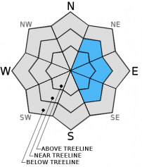
Overall, LOW avalanche danger will exist on all aspects and elevations today.
Watch for possible unstable wind slab formations on isolated terrain features on leeward NE-E-SE slopes above treeline. Wind slabs are not expected to present a significant hazard if safe backcountry travel techniques are used to help minimize risk. Normal caution is advised.


Avalanche Problem 1: Wind Slab
-
Character ?

-
Aspect/Elevation ?
-
Likelihood ?CertainVery LikelyLikelyPossible
 Unlikely
 -
Size ?HistoricVery LargeLargeSmall

Wind slabs are not expected to host a major hazard to backcountry recreation today granted normal caution is exercised. It was just reported that over this last weekend on Sunday (Dec 27th) a human triggered avalanche occurred on a SE aspect that drops into Avalanche Gulch proper, just below 50/50 flat. The wind slab avalanche propagated from the trigger point resulting in a width close to 100 feet and a crown depth of 1 foot. The avalanche traveled a short distance to the gully bottom and stopped. No one was caught in the slide. The couple inches of new snow from last night, and northwest winds over the coming days may form some very small wind slabs only in areas where conditions are perfect. New wind slabs will be small and shallow with poor development on a full slope scale.
What is "Normal Caution"? Here are a few tips:
-Expose only one person at a time to avalanche terrain, skinning up AND riding down.
-Travel from one safe zone to another. Is your "safe zone" really safe should a slide occur?
-Avoid traveling above terrain traps
-Don't group up in avalanche run out zones
-SPEAK UP! Call out your partner if you observe poor decision making.
Forecast Discussion
Mt. Shasta City was greeted with a fresh coat of white resulting from the storm system that slid across the area last night bringing 1-2 inches of new snow to the valley bottom. Similar totals were recorded at higher elevations both East and West of I-5 around Mt. Shasta. Skies will begin to clear today as a strong surface high pressure will develop over the region. Temperatures will remain cool, up to 10 degrees below normal, west of the Cascades. A strengthening inversion combined with low level moisture from the wet month will bring valley fog to some areas today and Thursday, diminishing in extent and duration later in the week. A strong East to West pressure gradient will result in Easterly winds. The dry East wind will help result in cold, hard freeze nights and cool, sunny afternoons on the West side of the Cascades. Enjoy what will hopefully be a short break in the stormy weather pattern December has experienced. It looks like close to 6-7 days until measurable precipitation factors into our local forecast.
THIS SEASON PRECIPITATION: Since October 1st (the wet season), we have received 9.45 inches of water, normal is 14.70 inches, putting us at 64% of normal. For the month of December, we have received 7.42 inches of water, normal is 7.34 inches, putting us at 101% of normal. For the year of 2015 we've received 26.63 inches of water, normal is 42.70 inches, putting us at 62% of normal
Recent Observations
Observations made yesterday on a short tour up "T-bar", just below Green Butte and Powder Bowl on Mt. Shasta, revealed continued powder snow conditions in protected areas below treeline. Reports from those who ventured above treeline were of less ideal conditions resulting from a crust layer on exposed slopes. No signs of instability were witnessed or reported. Over the course of the previous week several locations throughout the 60 square mile avalanche forecast area were visited with similar snow conditions observed. Below and near treeline, southerly aspects host a crust of variable depths and thickness with some shaded areas still holding powder. Above treeline, southerly facing, wind blown-icy ridges prevail with softer snow and wind packed powder in the gullies. Northerly aspects below and near treeline are still hosting soft snow, and are the best spots to find good skiing and riding. Consistent cold temperatures have kept our snow amazingly light and fluffy on these colder shaded aspects. The continued great snow conditions have been a real treat considering the past couple of sub-par winters we all have had to endure.
In case you did not get the memo, the persistent weak layer avalanche problem has subsided. It definitely made for an interesting couple of weeks in our local backcountry. It is a snowpack issue we typically do not deal with, but appears to have healed itself and will fade into winter history.
The wind slab avalanche problem could probably always be up on the advisory as Mt Shasta is a big mountain sticking up into the atmosphere and always receiving wind. That said, potentially dangerous wind slabs have been far and few between. We've been able to trigger very small slabs off ridge lines and bowls in steep, complex terrain but these small slabs have been insignificant. It was just reported to the MSAC this morning that a human triggered wind slab avalanche occurred this past weekend on Sunday (Dec. 27th) in Avalanche Gulch. The slide was triggered along the convexity at the top of one of the center moraines below 50/50 Flat dropping into Avalanche Gulch proper. The avalanche propagated from the trigger point resulting in a width of close to 100 feet, and a crown depth of around 12 inches. The slide traveled a short distance and stopped in the gully bottom. Our thinking is that larger, more dangerous slabs could possibly still exist in very isolated, extreme terrain above treeline in narrow cross-loaded couloirs, rocky outcrops with leeward depressions, and steep leeward areas that are able to catch snow. So, yes they still could exist, but where most people are riding and sliding, concerns are minimal. The couple inches of new snow from last night will provide snow available for transport, but is not expected to create any problems. Normal caution is advised, so keep your eyes peeled for a rogue wind slab, and continue to use safe travel practices. LOW avalanche danger is not the green light for complacency. Unstable snow on isolated terrain features could still result in an avalanche that could injure, bury, or kill someone.
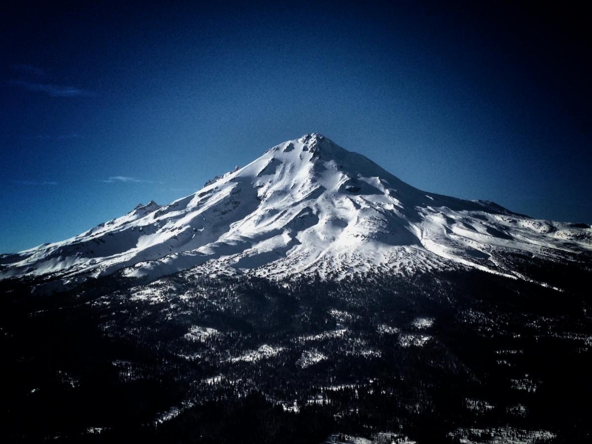
Mt Shasta viewed from Ash Creek Butte, 12/26/15. Photo: N Meyers
________________________________________________________________________________________________________________________________________________________________________
The Sand Flat cross country ski trails are in great shape and ready for your cross country skis or snow shoes. These are backcountry trails marked with blue diamonds on trees. Trails are not groomed. Snow shoers, please blaze a parallel trail to cross country skiers staying out of the skin track. Thank you, and enjoy!
The Pilgrim Creek Snowmobile Park is open! Trails are being groomed currently. Head to our "Education" tab on our website and find the snowmobile section for trail information, grooming status and other sledder resources!
The Five Red Flags of Avalanche Danger any time of year include: 1) Recent/current avalanche activity 2) Whumpfing sounds or shooting cracks 3) Recent/current heavy snowfall 4) Strong winds transporting snow 5) Rapid warming or rain on snow.
Weather and Current Conditions
Weather Summary
Good Morning! In Mt Shasta City at 0500, we have a current temperature of 30 F, seven degrees warmer than yesterday at this time, with overcast skies.
MOUNTAIN WEATHER STATION INFORMATION (0500hrs):
On Mt Shasta (South Side) in the last 24 hours...
Old Ski Bowl - 7,600 feet, the current temperature is 15 degrees F. Snow on the ground totals 59 inches with 2 inches new snow and no settlement. Temperatures have ranged from 11 F to 24 F.
Grey Butte - 8,000 feet, the current temperature is 14 degrees F. Temperatures have ranged from 12 F to 23 F. Winds have been averaging 10 mph and Westerly in direction, with a max gust to 28 mph out of the WNW.
Mt Eddy Range (West side of Interstate-5)...
Castle Lake - 5,600 feet, the current temperature is 20 degrees F. Temperatures have ranged from 16 F to 25 F. Snow on the ground measures 32 inches with 1 inch new snow and no settlement.
Mt Eddy - 6,500 feet, the current temperature is 16 degrees F. Temperatures have ranged from 13 F to 26 F. Snow on the ground measures 45 inches with no new snow and 1 inch settlement. Winds have averaged 2 mph and southerly in direction, with a max gust to 8 mph, SSE.
Always check the weather before you attempt to climb Mt Shasta. Further, monitor the weather as you climb. Becoming caught on the mountain in any type of weather can compromise life and limb. Be prepared.
| 0600 temperature: | 19 |
| Max. temperature in the last 24 hours: | 24 |
| Average wind direction during the last 24 hours: | WNW |
| Average wind speed during the last 24 hours: | 10 mi/hr |
| Maximum wind gust in the last 24 hours: | 28 mi/hr |
| New snowfall in the last 24 hours: | 1-2 inches |
| Total snow depth: | 59 inches |
Two Day Mountain Weather Forecast
Produced in partnership with the Medford NWS
| For 7000 ft to 9000 ft | |||
|---|---|---|---|
|
Wednesday (4 a.m. to 10 p.m.) |
Wednesday Night (10 p.m. to 4 a.m.) |
Thursday (4 a.m. to 10 p.m.) |
|
| Weather | Partly Cloudy then becoming mostly sunny. Snow showers likely before 7 am, and patchy freezing fog before 10 am. | Clear. | Sunny. |
| Temperature (°F) | 26 | 15 | 26 |
| Wind (mi/hr) | South/southwest 5-10 mph with gusts to 15 mph | East/northeast 5-10 mph with gusts to 15 mph | East/northeast 5-10 mph |
| Precipitation SWE / Snowfall (in) | / 0-.5 | / 0 | / 0 |
| For 9000 ft to 11000 ft | |||
| Wednesday | Wednesday Night | Thursday | |
| Weather | Partly cloudy then becoming sunny. Snow showers likely, mainly before 7 am. Patchy freezing fog before 10 am. Windy with wind chill values as low as -14 | Clear. Blustery with wind chill values as low as -4. | Sunny. Windy with wind chill values as low as -8 |
| Temperature (°F) | 18 | 17 | 17 |
| Wind (mi/hr) | North/northwest 20-25 mph with gusts to 45+ mph | North/northeast 0-.5 | East/northeast 20-25 mph with gusts to 40 mph |
| Precipitation SWE / Snowfall (in) | / 0-.5 | / 0 | / 0 |

