

You are here
Avalanche Advisory for 2015-12-31 06:56:05
- EXPIRED ON January 1, 2016 @ 6:56 amPublished on December 31, 2015 @ 6:56 am
- Issued by Jon Dove - Shasta-Trinity National Forest
Bottom Line
Overall, LOW avalanche danger will exist on all aspects and elevations today.
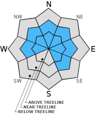
Watch for possible pockets of unstable wind slab formations on isolated features in steep, complex terrain on leeward SE-E-NE-N-NW-W apects at near and above treeline. Wind slabs are not expected to present a significant hazard if safe backcountry travel techniques are used to help minimize risk. Normal caution is advised.


Avalanche Problem 1: Wind Slab
-
Character ?

-
Aspect/Elevation ?
-
Likelihood ?CertainVery LikelyLikelyPossible
 Unlikely
 -
Size ?HistoricVery LargeLargeSmall

Wind slabs are once again not expected to host a major hazard to backcountry travelers today as long as normal caution is exercised. The amount of snow available for transport was relatively low, but shallow, isolated wind slabs could exist in the typical places; i.e. the tops of couloirs, low spots around rocky outcrops, just below ridge tops, etc. The couple inches of new snow from last night, and the East winds over the coming days may form some very small wind slabs in an expanding range to SE-E-NE-N-NW-W aspects. New wind slabs will be small in size and shallow in depth with poor development on a full slope scale.
What is "Normal Caution"? Here are a few tips:
-Expose only one person at a time to avalanche terrain, skinning up AND riding down.
-Travel from one safe zone to another. Is your "safe zone" really safe should a slide occur?
-Avoid traveling above terrain traps
-Don't group up in avalanche run out zones
-SPEAK UP! Call out your partner if you observe poor decision making.
Forecast Discussion
A brisk morning nipped at my whiskers when I stepped outside to warm up my truck today. The cold crisp air is the result of an area of high pressure that has built over Washington extending into Southern Oregon and Northern California. The high pressure being centered further to the north is creating a Rex Blocking pattern which in turn is creating dry and cold East winds coming over the Cascade crest. There is the chance for dangerously low wind chills at ridge top levels as chilled East winds blow across. A strong inversion on the West side will create valley fog and freezing fog as well as air stagnation due to low mixing heights. This weather patter is expected to change beginning late Saturday afternoon as the Rex Block starts the process of breaking down and moving to the East on Sunday. A warm front will push temperatures up 4-8 degrees by Sunday as a chance of precipitation moves back into our forecast. According to NOAA meteorologists (BTL) models are trending wetter early next week and "it's quite possible the Mount Shasta snow machine turn on sometime next week." That would make for the start of a very happy new year! Enjoy the next few cool sunny days!
THIS SEASON PRECIPITATION: Since October 1st (the wet season), we have received 9.49 inches of water, normal is 14.96 inches, putting us at 63% of normal. For the month of December, we have received 7.46 inches of water, normal is 7.60 inches, putting us at 98% of normal. For the year of 2015 we've received 26.67 inches of water, normal is 42.96 inches, putting us at 62% of normal
Recent Observations
Powder snow was once again the order of the day, however, poor visibility limited terrain options to near and below treeline for the majority of the day. That was fine because better snow conditions were found in these more protected slopes. A tour up to lower Broadway revealed a bit of a mixed bag in terms of snow conditions. Soft, carvable snow was intermixed with patches of wind scoured crust. Freezing fog may have created a fine "zipper" crust in some locations below treeline, as well. There were no signs of instability found while looking for evidence of wind slabs, and a quick snow pit dug at the top of "Gerald's Bowl" in the vicinity of lower Sun Bowl to perform an extended column test resulted in a score of ECTX.
The wind slab avalanche problem is probably the most common issue on Mt Shasta as it is stands as a solitary monolith sticking up into the atmosphere and always receiving wind. These winds eagerly transport snow swirling it around the mountain side creating wind slabs. Snow instabilities associated with these formations tend to improve over a couple of days. That being said, where wind slabs have been found they have been stubborn to trigger. There is still potential to find the right mix of conditions in steep, complex terrain above treeline and below ridge tops in non-typical starting zones where a small wind slab avalanche could be triggered. So, yes they still could exist, but where most people are skiing/riding/snowmobiling concerns are minimal. The couple inches of new snow from early yesterday has provided snow available for transport, but is not expected to create any additional problems. Normal caution is advised. Avoid areas where wind slabs could have formed, only expose one person at a time to avalanche terrain, regroup in "safe" spots out of avalanche paths, avoid terrain traps, and have open communication with in your group. LOW avalanche danger is not the green light for complacency. Unstable snow on isolated terrain features could still result in an avalanche that could injure, bury, or kill someone.
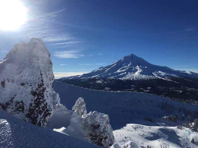
East Side of Mt. Shasta from Ash Cr Butte 12-27-2015. photo: Jon Dove
________________________________________________________________________________________________________________________________________________________________________
The Sand Flat cross country ski trails are in great shape and ready for your cross country skis or snow shoes. These are backcountry trails marked with blue diamonds on trees. Trails are not groomed. Snow shoers, please blaze a parallel trail to cross country skiers staying out of the skin track. Thank you, and enjoy!
The Pilgrim Creek Snowmobile Park is open! Trails are being groomed currently. Head to our "Education" tab on our website and find the snowmobile section for trail information, grooming status and other sledder resources!
The Five Red Flags of Avalanche Danger any time of year include: 1) Recent/current avalanche activity 2) Whumpfing sounds or shooting cracks 3) Recent/current heavy snowfall 4) Strong winds transporting snow 5) Rapid warming or rain on snow.
Weather and Current Conditions
Weather Summary
Good Morning! In Mt Shasta City at 0500, we have a current temperature of 18 F, twelve degrees cooler than yesterday at this time, with clear skies and calm wind.
MOUNTAIN WEATHER STATION INFORMATION (0500hrs):
On Mt Shasta (South Side) in the last 24 hours...
Old Ski Bowl - 7,600 feet, the current temperature is 21 degrees F. Snow on the ground totals 57 inches with 2 inches of settlement. Temperatures have ranged from 11 F to 21 F.
Grey Butte - 8,000 feet, the current temperature is 21 degrees F. Temperatures have ranged from 11 F to 21 F. Winds have been averaging 16 mph and Easterly in direction, with a max gust to 42 mph out of the ENE.
Mt Eddy Range (West side of Interstate-5)...
Castle Lake - 5,600 feet, the current temperature is 18 degrees F. Temperatures have ranged from 18 F to 27 F. Snow on the ground measures 30 inches with 2 inches of settlement.
Mt Eddy - 6,500 feet, the current temperature is 14 degrees F. Temperatures have ranged from 12 F to 22 F. Snow on the ground measures 45 inches with no new snow and no settlement. Winds have averaged 2 mph and variable in direction, with a max gust to 9 mph, SE.
Always check the weather before you attempt to climb Mt Shasta. Further, monitor the weather as you climb. Becoming caught on the mountain in any type of weather can compromise life and limb. Be prepared.
| 0600 temperature: | 7 |
| Max. temperature in the last 24 hours: | 24 |
| Average wind direction during the last 24 hours: | Variable |
| Average wind speed during the last 24 hours: | 16 mi/hr |
| Maximum wind gust in the last 24 hours: | 42 mi/hr |
| New snowfall in the last 24 hours: | 0 inches |
| Total snow depth: | 57 inches |
Two Day Mountain Weather Forecast
Produced in partnership with the Medford NWS
| For 7000 ft to 9000 ft | |||
|---|---|---|---|
|
Thursday (4 a.m. to 10 p.m.) |
Thursday Night (10 p.m. to 4 a.m.) |
Friday (4 a.m. to 10 p.m.) |
|
| Weather | Sunny | Clear. Wind chill values as low as -3 | Sunny. Wind chill values as low as zero. |
| Temperature (°F) | 25 | 15 | 21 |
| Wind (mi/hr) | East/northeast 5-10 mph with gusts to 15 mph | East 10-15 mph with gusts to 20+ mph | East 10-15 mph with gusts to 20+ mph |
| Precipitation SWE / Snowfall (in) | / 0 | / 0 | / 0 |
| For 9000 ft to 11000 ft | |||
| Thursday | Thursday Night | Friday | |
| Weather | Sunny. Windy with wind chill values as low as -14 | Clear. Windy with wind chill values as low as -15. | Sunny. Windy with wind chill values as low as -12. |
| Temperature (°F) | 19 then falling to 14 | 11 | 12 |
| Wind (mi/hr) | North/northeast 20-25 mph with gusts to 40+ mph | East 0 | Southeast 15-20 mph with gusts to 30 mph |
| Precipitation SWE / Snowfall (in) | / 0 | / 0 | / 0 |

