

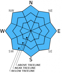
You are here
Avalanche Advisory for 2016-01-01 06:02:54
- EXPIRED ON January 2, 2016 @ 6:02 amPublished on January 1, 2016 @ 6:02 am
- Issued by Jon Dove - Shasta-Trinity National Forest
Bottom Line
Overall, LOW avalanche danger will exist on all aspects and elevations today.
While avalanches remain unlikely, some unstable snow could exist on isolated steep terrain features. Any remaining wind slabs are not expected to present a significant hazard if safe backcountry travel techniques are used to help minimize risk. Normal caution is advised.


Avalanche Problem 1: Normal Caution
-
Character ?

-
Aspect/Elevation ?
-
Likelihood ?CertainVery LikelyLikelyPossible
 Unlikely
 -
Size ?HistoricVery LargeLargeSmall

Wind slabs do exist in areas above treeline, but evidence found yesterday indicated continued bonding of wind deposit snow with old snow underneath. Some cornices still linger over previously wind loaded slopes. Be sure to give them plenty of room as there was evidence of cornice failure in Powder Bowl. Continue to practice normal caution and safe travel techniques when enjoying the sunny weather out in the backcountry.
What is "Normal Caution"? Here are a few tips:
-Expose only one person at a time to avalanche terrain, skinning up AND riding down.
-Travel from one safe zone to another. Is your "safe zone" really safe should a slide occur?
-Avoid traveling above terrain traps
-Don't group up in avalanche run out zones
-SPEAK UP! Call out your partner if you observe poor decision making.
Forecast Discussion
A record dry air mass that is still parked over the region with it's dry and cold East winds will keep temperatures at bitterly cold levels for the New Year. The strong ridge and blocking pattern will not last long (unlike the previous two winters) allowing a return to a more seasonal, progressive pattern open to systems from the Pacific. Expect clear and sunny conditions with continued dry and cold air through Saturday. A brief disturbance will pass through Saturday night into early Sunday bringing a chance of snow then a few sun breaks. By Monday it looks like we will be returning to wet and snowy winter weather. We will keep our fingers crossed.
THIS SEASON PRECIPITATION: Since October 1st (the wet season), we have received 9.49 inches of water, normal is 14.96 inches, putting us at 63% of normal. For the month of December, we have received 7.46 inches of water, normal is 7.60 inches, putting us at 98% of normal. For the year of 2015 we've received 26.67 inches of water, normal is 42.96 inches, putting us at 62% of normal
Recent Observations
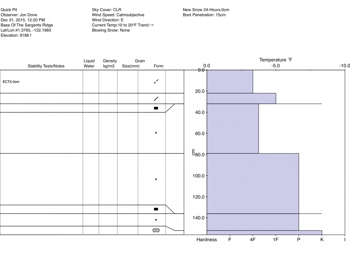
Yesterday made for a beautiful way to end 2015 with crisp sunny skies and mostly calm winds on the South side of Mt. Shasta. East winds were blocked by the mountain making for pleasant ski/split board touring above treeline. In an effort to go and search for wind slabs I made my way up into Old Ski Bowl toward Sargents ridge with the intent of skiing Shastarama. The winds affect on the snow was obvious with notably wind scoured areas, and areas of wind deposit snow. Snow conditions in areas where snow had been deposited by previous high winds was generally soft, yet variable with some spots of Styrofoam like chalky snow. The skiing was decent, but better, softer snow was found at and below treeline. A snow study pit was dug at the base of Sargents ridge at an elevation of 9,150 ft. on a SW aspect with a 20 degree slope. I dug down to the crust layer from Dec 8th-10th to look at the snowpack structure in an exposed above treeline location. Firm, wind deposited snow with slight changes in density defining the layers makes up the majority of the snowpack. There was no evidence of faceting of snow crystals around the crust layer. An extended column test was performed in two different locations both scoring ECTX. The wind slab formations at this location were thick and stubborn to fracture while tugging on the column after the ECT was completed.
That being said , there is still potential to find the right mix of conditions in steep, complex terrain above treeline and below ridge tops in non-typical starting zones where a small wind slab avalanche could be triggered. Normal caution is advised. Safe travel techniques should be followed. Only expose one person at a time to avalanche terrain, regroup in "safe" spots out of avalanche paths, avoid terrain traps, and have open communication with in your group. LOW avalanche danger is not the green light for complacency. Unstable snow on isolated terrain features could still result in an avalanche that could injure, bury, or kill someone.
Quick Pit Profile from the base of Sargents Ridge 12-31-2015 by Jon Dove:
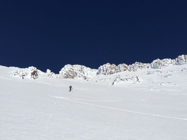
Harrison skinning up toward Shastarama 12/31/2015-photo: Jon Dove
________________________________________________________________________________________________________________________________________________________________________
The Sand Flat cross country ski trails are in great shape and ready for your cross country skis or snow shoes. These are backcountry trails marked with blue diamonds on trees. Trails are not groomed. Snow shoers, please blaze a parallel trail to cross country skiers staying out of the skin track. Thank you, and enjoy!
The Pilgrim Creek Snowmobile Park is open! Trails are being groomed currently. Head to our "Education" tab on our website and find the snowmobile section for trail information, grooming status and other sledder resources!
The Five Red Flags of Avalanche Danger any time of year include: 1) Recent/current avalanche activity 2) Whumpfing sounds or shooting cracks 3) Recent/current heavy snowfall 4) Strong winds transporting snow 5) Rapid warming or rain on snow.
Weather and Current Conditions
Weather Summary
Good Morning! In Mt Shasta City at 0500, we have a current temperature of 10 F, eight degrees cooler than yesterday at this time, with clear skies and light wind 5-10 mph.
MOUNTAIN WEATHER STATION INFORMATION (0500hrs):
On Mt Shasta (South Side) in the last 24 hours...
Old Ski Bowl - 7,600 feet, the current temperature is 16 degrees F. Snow on the ground totals 55 inches with 2 inches of settlement. Temperatures have ranged from 13 F to 26 F.
Grey Butte - 8,000 feet, the current temperature is 13 degrees F. Temperatures have ranged from 13 F to 24 F. Winds have been averaging 33 mph and ENE in direction, with a max gust to 56 mph out of the ENE.
Mt Eddy Range (West side of Interstate-5)...
Castle Lake - 5,600 feet, the current temperature is 15 degrees F. Temperatures have ranged from 13 F to 22 F. Snow on the ground measures 30 inches with no settlement.
Mt Eddy - 6,500 feet, the current temperature is 14 degrees F. Temperatures have ranged from 12 F to 25 F. Snow on the ground measures 45 inches with no new snow and no settlement. Winds have averaged 3 mph and variable in direction, with a max gust to 14 mph, SW.
Always check the weather before you attempt to climb Mt Shasta. Further, monitor the weather as you climb. Becoming caught on the mountain in any type of weather can compromise life and limb. Be prepared.
| 0600 temperature: | 17 |
| Max. temperature in the last 24 hours: | 23 |
| Average wind direction during the last 24 hours: | Easterly |
| Average wind speed during the last 24 hours: | 33 mi/hr |
| Maximum wind gust in the last 24 hours: | 56 mi/hr |
| New snowfall in the last 24 hours: | 0 inches |
| Total snow depth: | 55 inches |
Two Day Mountain Weather Forecast
Produced in partnership with the Medford NWS
| For 7000 ft to 9000 ft | |||
|---|---|---|---|
|
Friday (4 a.m. to 10 p.m.) |
Friday Night (10 p.m. to 4 a.m.) |
Saturday (4 a.m. to 10 p.m.) |
|
| Weather | Sunny. Wind chill values as low as -1. | Clear. Wind chill values as low as -8 | Sunny. Wind chill values as low as -2. |
| Temperature (°F) | 23 | 7 | 24 |
| Wind (mi/hr) | East/southeast 10-15 with gusts to 25 mph | East/southeast 10-15 mph with gusts to 20 mph | South/southeast 10-15 mph with gusts to 20 mph |
| Precipitation SWE / Snowfall (in) | / 0 | / 0 | / 0 |
| For 9000 ft to 11000 ft | |||
| Friday | Friday Night | Saturday | |
| Weather | Sunny. Windy with wind chill values as low as -11 | Clear. Breezy with wind chill values as low as -11. | Sunny. Breezy with wind chill values as low as -6. |
| Temperature (°F) | 11 | 8 | 14 |
| Wind (mi/hr) | East 20-25 mph with gusts to 40+ mph | East 0 | Southwest 15-20 mph with gusts to 30 mph |
| Precipitation SWE / Snowfall (in) | / 0 | / 0 | / 0 |

