

You are here
Avalanche Advisory for 2016-01-03 06:37:42
- EXPIRED ON January 4, 2016 @ 6:37 amPublished on January 3, 2016 @ 6:37 am
- Issued by Jon Dove - Shasta-Trinity National Forest
Bottom Line
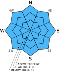
Overall, LOW avalanche danger will exist on all aspects and elevations today.
While avalanches remain unlikely, some unstable snow could exist on isolated steep terrain features. Any remaining wind slabs are NOT expected to present a significant hazard if safe backcountry travel techniques are used to help minimize risk. Normal caution is advised.


Avalanche Problem 1: Normal Caution
-
Character ?

-
Aspect/Elevation ?
-
Likelihood ?CertainVery LikelyLikelyPossible
 Unlikely
 -
Size ?HistoricVery LargeLargeSmall

Wind slabs do exist in areas above treeline, but evidence found both yesterday and Friday indicated continued bonding of wind deposit snow with old snow underneath. Some cornices still linger over previously wind loaded slopes. Be sure to give them plenty of room. Continue to practice normal caution and safe travel techniques when enjoying the the soft snow out in the backcountry today. Avalanche danger will increase with the significant amount of new snow in the immediate forecast, especially considering surface hoar that has developed and will be buried. It could present another round of the persistent weak layer avalanche problem. We will be monitoring this layer over the coming days.
"Normal Caution" refers to safe travel practices that should be exercised during every tour, which include:
-Expose only one person at a time to avalanche terrain, both skinning up AND riding down.
-Avoid areas with possibly unstable snow.
-Travel from one safe zone to another crossing avalanche paths one at a time, and avoiding terrain traps. Is your "safe zone" really safe if a slide were to occur?
-Communicate clearly and often with your travel partners. Don't be afraid to speak up if you notice poor decision making or any "red flags".
Forecast Discussion
Today a warm front overruns the very dry and cold air mass that has been parked over the region for the past several days accompanied by a band of precipitation. Any precip amounts today will be very light. A quick "break" in between systems will occur tonight as shortwave ridging will reduce chances of precipitation to close to nil. Low pressure over the Pacific just offshore will strengthen on Monday ushering in an active weather pattern focused over Northern California. This should bring a period of moderate to heavy snow to the Mount Shasta area with snow levels down to 3,500 feet. 3-6 inches of snow are expected at lower elevations with higher totals as you go up. Generally unsettled weather will continue through the week. The storm forecast for late Monday into Tuesday will be the most pronounced, but chances of precipitation will continue into Friday.
THIS SEASON PRECIPITATION: Since October 1st (the wet season), we have received 9.49 inches of water, normal is 15.69 inches, putting us at 60% of normal. For the month of January, we have received 0.00 inches of water, normal is 0.48 inches, putting us at 0% of normal. For the year of 2016 we've received 0.00 inches of water, normal is 0.48 inches, putting us at 0% of normal
Recent Observations
Yesterday presented mostly clear skies and cold conditions as clouds from early in the day began to break up letting the sun shine in. In terms of snow pack structure and stability there is not much new to report. The one thing that sticks out, however, is the widespread development of surface hoar in protected areas mainly at and below treeline. It was observed on the snow around Bunny Flat, as well as on the Trinity Divide near Parks Cr. summit. The clear and cold nights have sucked water vapor up from within the snowpack to form the classic feathery surface hoar crystals on the surface of the snow. While making the snow beautiful and fun to ski through, surface hoar could be problematic in our near future. Observations made yesterday on the more northerly facing aspect near Parks Cr. summit revealed surface hoar development of 1-2 inches thick. Once they become buried by future snow fall they will become a potentially weak layer within the upper snowpack. With snow levels forecast to be generally low, the chances of surface hoar crystals maintaining there shape and structure are high. It could present another round of persistent weak layer avalanche problems for our forecast area if temperatures remain cold. We will be monitoring this snow layer as it gets buried over the course of this coming week. The skiing/riding on shaded, northerly aspects remains awesome with powder snow conditions.
For today avalanche danger will again be LOW. Normal caution is advised. Safe travel techniques should be followed. Only expose one person at a time to avalanche terrain, regroup in "safe" spots out of avalanche paths, avoid terrain traps, and have open communication with in your group. LOW avalanche danger is not the green light for complacency. Unstable snow on isolated terrain features could still result in an avalanche that could injure, bury, or kill someone.
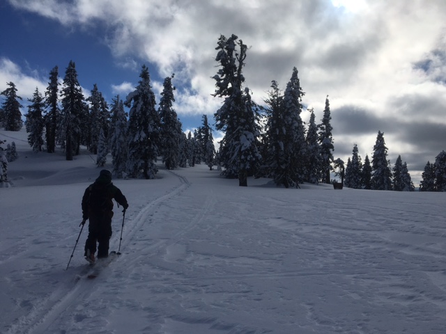
Devin Knight skinning towards ridge at Parks Cr. summit, north of Mt. Eddy 1/2/2016-photo: Jon Dove
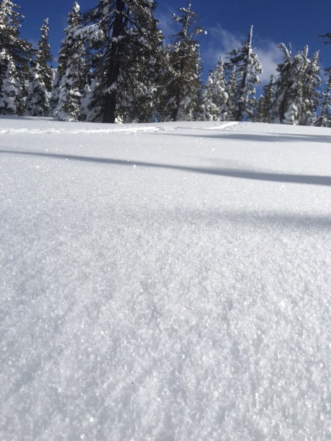
Surface hoar development on snow along ridge near Parks Cr. summit, north of Mt. Eddy 1/2/2016-photo: Jon Dove
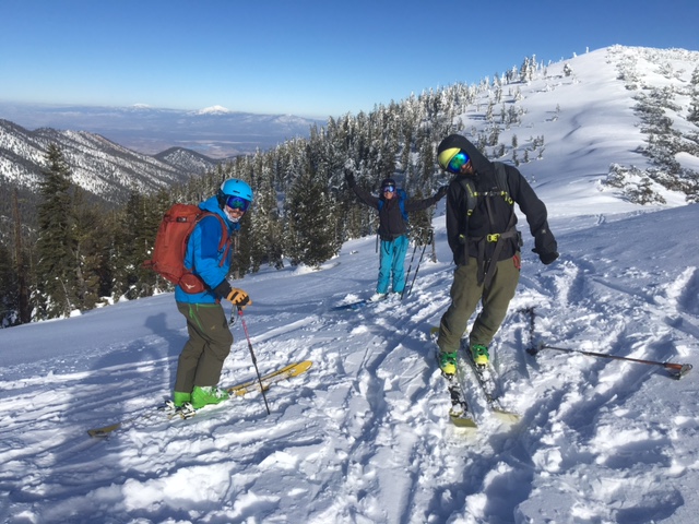
Happy folks (the Malee's and Koster) about to drop in to shaded Northerly aspect pow near Parks Cr. summit 1/2/2015-photo: Jon Dove
_______________________________________________________________________________________________________________________________________________________________________
The Sand Flat cross country ski trails are in great shape and ready for your cross country skis or snow shoes. These are backcountry trails marked with blue diamonds on trees. Trails are not groomed. Snow shoers, please blaze a parallel trail to cross country skiers staying out of the skin track. Thank you, and enjoy!
The Pilgrim Creek Snowmobile Park is open! Trails are being groomed currently. Head to our "Education" tab on our website and find the snowmobile section for trail information, grooming status and other sledder resources!
The Five Red Flags of Avalanche Danger any time of year include: 1) Recent/current avalanche activity 2) Whumpfing sounds or shooting cracks 3) Recent/current heavy snowfall 4) Strong winds transporting snow 5) Rapid warming or rain on snow.
Weather and Current Conditions
Weather Summary
Good Morning! In Mt Shasta City at 0500, we have a current temperature of 34 F, thirteen degrees warmer than yesterday at this time, with mostly cloudy skies and an occasional snow flake. Winds are calm 0-5 mph, SSW.
MOUNTAIN WEATHER STATION INFORMATION (0500hrs):
On Mt Shasta (South Side) in the last 24 hours...
Old Ski Bowl - 7,600 feet, the current temperature is 24 degrees F. Snow on the ground totals 52 inches with 1 inch settlement. Temperatures have ranged from 11 F to 24 F.
Grey Butte - 8,000 feet, the current temperature is 22 degrees F. Temperatures have ranged from 10 F to 22 F. Winds have been averaging 7 mph and Southerly in direction, with a max gust to 21 mph out of the SSE.
Mt Eddy Range (West side of Interstate-5)...
Castle Lake - 5,600 feet, the current temperature is 27 degrees F. Temperatures have ranged from 15 F to 28 F. Snow on the ground measures 29 inches with no settlement.
Mt Eddy - 6,500 feet, the current temperature is 25 degrees F. Temperatures have ranged from 14 F to 26 F. Snow on the ground measures 44 inches with no new snow and no settlement. Winds have averaged 2 mph SSW in direction, with a max gust to 11 mph, SSW.
Always check the weather before you attempt to climb Mt Shasta. Further, monitor the weather as you climb. Becoming caught on the mountain in any type of weather can compromise life and limb. Be prepared.
| 0600 temperature: | 26 |
| Max. temperature in the last 24 hours: | 26 |
| Average wind direction during the last 24 hours: | Southerly |
| Average wind speed during the last 24 hours: | 7 mi/hr |
| Maximum wind gust in the last 24 hours: | 21 mi/hr |
| New snowfall in the last 24 hours: | 0 inches |
| Total snow depth: | 52 inches |
Two Day Mountain Weather Forecast
Produced in partnership with the Medford NWS
| For 7000 ft to 9000 ft | |||
|---|---|---|---|
|
Sunday (4 a.m. to 10 p.m.) |
Sunday Night (10 p.m. to 4 a.m.) |
Monday (4 a.m. to 10 p.m.) |
|
| Weather | Mostly cloudy. Snow likely, mainly before 10 am. Breezy | Mostly cloudy. 30% chance of snow, mainly after 10 pm. | Mostly cloudy. Snow, mainly after 4 pm. Chance of snow is 80% |
| Temperature (°F) | 31 | 24 | 29 |
| Wind (mi/hr) | South/southeast 20-25 mph with gusts to 30 mph | Southeast 15-20 mph with gusts to 30 mph | South/southeast 10-15 mph with gusts to 25 mph |
| Precipitation SWE / Snowfall (in) | / 0-0.5 | / 0-0.5 | / 1-2 |
| For 9000 ft to 11000 ft | |||
| Sunday | Sunday Night | Monday | |
| Weather | Mostly cloudy. Snow, mainly before 10 am. Chance of precipitation is 80%. Windy | Mostly cloudy. 30% chance of snow, mainly after 10 pm. Windy with wind chill values as low as zero. | Cloudy. Snow likely, mainly after 4 pm. Chance of precipitation is 60%. Windy with wind chill values as low as -4. |
| Temperature (°F) | 23 | 20 | 17 |
| Wind (mi/hr) | South increasing in the afternoon 25-35 mph increasing to 35-45 mph in the afternoon. Higher gusts are possible. | South/southwest 0-0.5 | South 20-25 mph with gusts to 45 mph |
| Precipitation SWE / Snowfall (in) | / 0-0.5 | / 0-0.5 | / 1-2 |

