

You are here
Avalanche Advisory for 2016-01-05 07:08:05
- EXPIRED ON January 6, 2016 @ 7:08 amPublished on January 5, 2016 @ 7:08 am
- Issued by Nick Meyers - Shasta-Trinity National Forest
Bottom Line
Heavy snowfall, currently and over the past 12 hours, moderate southerly winds and areas of existing surface hoar have created dangerous avalanche conditions today. Natural avalanches are possible and human triggered avalanches are likely.
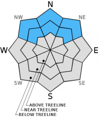
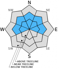
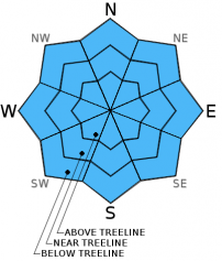
Near and above treeline, CONSIDERABLE avalanche danger will exist with pockets of HIGH danger on NW-N-NE facing slopes.
Below treeline, expect MODERATE avalanche danger with pockets of CONSIDERABLE on NW-N-NE aspects.


Avalanche Problem 1: Persistent Slab
-
Character ?

-
Aspect/Elevation ?
-
Likelihood ?CertainVery LikelyLikelyPossible
 Unlikely
 -
Size ?HistoricVery LargeLargeSmall

Buried surface hoar is a dangerous and scary avalanche problem. We have high uncertainty where surface hoar has been preserved over the past few days. Observations of the best preservation has been on northerly aspects from 6,500 to 8,000 feet. It's going to be difficult to discern where buried surface hoar may exist now. Stay off of northerly slopes steeper than 32 degrees. As new snow and wind transported snow builds on top of this layer, the consequences become greater should it release.
Avalanche Problem 2: Wind Slab
-
Character ?

-
Aspect/Elevation ?
-
Likelihood ?CertainVery LikelyLikelyPossible
Unlikely
-
Size ?HistoricVery LargeLargeSmall
Since the onset of the storm yesterday afternoon, Gray Butte weather station (8,000 feet on Mt Shasta) has recorded average wind speeds of 15-20 mph with gusts 25-30 mph. Wind slabs are certain today and the danger will increase as wind slabs gain size. Moderate southerly winds will quickly deposit snow onto leeward W-NW-N-NE facing slopes today. Slab depths could reach several feet in thickness and become sensitive to trigger. Above treeline, open slope travel is not advised today. You likely wouldn't be able to see your ski tips anyways.
Avalanche Problem 3: Storm Slab
-
Character ?

-
Aspect/Elevation ?
-
Likelihood ?CertainVery LikelyLikelyPossible
Unlikely
-
Size ?HistoricVery LargeLargeSmall
Storm slabs are a soft cohesive layer (slab) of new snow which breaks within the storm snow or on the old snow surface. Storm slabs will be possible on all aspects and all elevations today due to rapid accumulation of snow.
Forecast Discussion
Currently, we have heavy snowfall in the area with snow levels just above town, about 3,500 feet. Snow levels will drop throughout the day as cold air pushes onshore. High precipitation rates may drive snow levels lower also. Already, we've received .58 inches of water in the last 12 hours and 5-8 inches of new snow recorded at local weather stations (Castle Lake, Mt Eddy, Mt Shasta). The weather will ease up later today though another system will sweep in tonight and Wednesday. This system is very similar to the current system and will bring continued snow, heavy at times. Snow levels will be lower with this second system and we will see a few inches of snow in town at the least. So the short of it: heavy snow this morning tapering off throughout the day, another storm late tonight and tomorrow. By the time both storms are finished with us, water totals could be as much as 1.75 to 2.0 inches, translating into several feet of new snow in the mountains. Winds have been blowing southeast and will continue as such. Moderate wind speeds near and above treeline, averaging 10-20 mph with gusts to 40 mph will accompany both storms with the highest wind speeds expected tomorrow. The implication from all this: increased avalanche danger!
THIS SEASON PRECIPITATION: Since October 1st (the wet season), we have received 9.80 inches of water, normal is 16.15 inches, putting us at 60% of normal. For the month of January and year of 2016 we've received 0.31 inches of water, normal is 0.94 inches, putting us at 32% of normal
Recent Observations
Yesterday did not present any new observations and our main focus was the incoming storm and potential impacts. The forecast area is hosting a few different issues: pockets of existing surface hoar now buried by new snow and our old faithful wind/storm slabs. Today is going to present a couple different avalanche problems. Of most concern is the new snow on top of existing surface hoar formations. We've spoken of this widespread surface hoar observed over the forecast area during the past few days. Buried surface hoar is a classic weak layer and potentially dangerous avalanche problem. Above treeline is not a concern for this problem as wind keeps things tidy up there. Rather, below and near treeline where the feathery crystals were preserved, protected areas out of the wind and on cold, shady aspects....these areas are going to be the best areas for preserved surface hoar to, as we speak, be buried by new snow. Aspects NW-N-NE, 6,500 to 8,000 feet will host the best chance of said problem. As new snow accumulates and wind loading exacerbates accumulation, this only adds stress to the weak layer over a very short period of time. Southerly winds will only increase the chance of tipping the stress vs. strength ratio on these northerly aspects. Over the last two hours, over a tenth of an inch of water per hour has fallen on the mountain, or 2 inches of snow per hour. Snow does not like rapid change.
The second concern for today, you guessed it, wind slabs near and above treeline. Winds have been perfect for wind loading... not too windy to completely sublimate the snow, but a nice moderate wind to load leeward slopes to perfection. Wind can load leeward slopes 10x faster than falling snow. Combine high precipitation rates already with wind loading and you get the picture. Leeward W-NW-N-NE-E, or in other words, the top half of the compass rose will be the most heavily wind loaded aspects, again near and above treeline.
Safe travel techniques should always be followed, regardless of avalanche danger. Only expose one person at a time to avalanche terrain, regroup in "safe" spots out of avalanche paths, avoid terrain traps, and have open communication with in your group.
____________________________________________________________________________________________________________________________________________________________________
The Sand Flat cross country ski trails are in great shape and ready for your cross country skis or snow shoes. These are backcountry trails marked with blue diamonds on trees. Trails are not groomed. Snow shoers, please blaze a parallel trail to cross country skiers staying out of the skin track. Thank you, and enjoy!
The Pilgrim Creek Snowmobile Park is open! Trails are being groomed currently. Head to our "Education" tab on our website and find the snowmobile section for trail information, grooming status and other sledder resources!
The Five Red Flags of Avalanche Danger any time of year include: 1) Recent/current avalanche activity 2) Whumpfing sounds or shooting cracks 3) Recent/current heavy snowfall 4) Strong winds transporting snow 5) Rapid warming or rain on snow.
Weather and Current Conditions
Weather Summary
Good Morning! In Mt Shasta City at 0500, we have a current temperature of 34 F, two degrees cooler than yesterday at this time, and rain/snow currently.
MOUNTAIN WEATHER STATION INFORMATION (0500hrs):
On Mt Shasta (South Side) in the last 24 hours...
Old Ski Bowl - 7,600 feet, the current temperature is 26 degrees F. Snow on the ground totals 55 inches with 6 inches new snow (.58 inches water) and no settlement. Temperatures have ranged from 23 F to 27 F.
Grey Butte - 8,000 feet, the current temperature is 24 degrees F. Temperatures have ranged from 21 F to 25 F. Winds have been averaging 15 mph and southerly in direction, with a max gust to 42 mph out of the southeast.
Mt Eddy Range (West side of Interstate-5)...
Castle Lake - 5,600 feet, the current temperature is 28 degrees F. Temperatures have ranged from 27 F to 32 F. Snow on the ground measures 38 inches with 8 inches new snow and no settlement.
Mt Eddy - 6,500 feet, the current temperature is 27 degrees F. Temperatures have ranged from 26 F to 28 F. Snow on the ground measures 50 inches with 7 inches new snow and no settlement. Winds have averaged 3 mph SSW in direction, with a max gust to 18 mph, SSW.
Always check the weather before you attempt to climb Mt Shasta. Further, monitor the weather as you climb. Becoming caught on the mountain in any type of weather can compromise life and limb. Be prepared.
| 0600 temperature: | 28 |
| Max. temperature in the last 24 hours: | 30 |
| Average wind direction during the last 24 hours: | Southeast |
| Average wind speed during the last 24 hours: | 10-15 mph mi/hr |
| Maximum wind gust in the last 24 hours: | 42 mi/hr |
| New snowfall in the last 24 hours: | 6-8 inches |
| Total snow depth: | 56 inches |
Two Day Mountain Weather Forecast
Produced in partnership with the Medford NWS
| For 7000 ft to 9000 ft | |||
|---|---|---|---|
|
Tuesday (4 a.m. to 10 p.m.) |
Tuesday Night (10 p.m. to 4 a.m.) |
Wednesday (4 a.m. to 10 p.m.) |
|
| Weather | Snow, breezy | Snow, breezy | Snow, breezy |
| Temperature (°F) | 31 | 23 | 27 |
| Wind (mi/hr) | South/southeast 10-15 mph | South/southeast 10-15 mph | South/southeast 15-20 mph |
| Precipitation SWE / Snowfall (in) | / 3-7 | / 1-3 | / 3-7 |
| For 9000 ft to 11000 ft | |||
| Tuesday | Tuesday Night | Wednesday | |
| Weather | Snow and windy | Snow, windy | Heavy snow and windy |
| Temperature (°F) | 17 | 12 | 13 |
| Wind (mi/hr) | South 30-40 mph | South 4-8 | South 40-50 mph |
| Precipitation SWE / Snowfall (in) | / 4-8 | / 2-4 | / 4-8 |

