

You are here
Avalanche Advisory for 2016-01-06 06:59:01
- EXPIRED ON January 7, 2016 @ 6:59 amPublished on January 6, 2016 @ 6:59 am
- Issued by Jon Dove - Shasta-Trinity National Forest
Bottom Line
Heavy snowfall, currently and over the past 24 hours, moderate southerly winds and areas of existing surface hoar have created dangerous avalanche conditions today. Natural avalanches are possible and human triggered avalanches are likely.
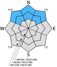
Near and above treeline, CONSIDERABLE avalanche danger will exist with pockets of HIGH danger on leeward W-NW-N-NE-E facing slopes.
Below treeline, expect MODERATE avalanche danger with pockets of CONSIDERABLE on NW-N-NE aspects.


Avalanche Problem 1: Persistent Slab
-
Character ?

-
Aspect/Elevation ?
-
Likelihood ?CertainVery LikelyLikelyPossible
 Unlikely
 -
Size ?HistoricVery LargeLargeSmall

Buried surface hoar is a dangerous and scary avalanche problem. We have high uncertainty where surface hoar has been preserved over the past few days. Observations of the best preservation has been on northerly aspects from 6,500 to 8,000 feet. It's going to be difficult to discern where buried surface hoar may exist now. Stay off of northerly slopes steeper than 32 degrees near and below treeline. As new snow and wind transported snow builds on top of this layer, the consequences become greater should it release. Do not let your gaurd down just because you are below treeline. Avalanches can still occur in these areas, especially in areas of openly spaced, old growth forest or gladed areas.
Avalanche Problem 2: Wind Slab
-
Character ?

-
Aspect/Elevation ?
-
Likelihood ?CertainVery LikelyLikelyPossible
Unlikely
-
Size ?HistoricVery LargeLargeSmall
Since the onset of the yesterdays storm, Grey Butte weather station (8,000 feet on Mt Shasta) has recorded average wind speeds of 15-20 mph with gusts 25-35 mph. Wind slabs are certain today and the danger will increase as wind slabs gain size. Moderate southerly winds will quickly deposit snow onto leeward W-NW-N-NE facing slopes today. Slab depths could reach several feet in thickness and become sensitive to trigger. Above treeline, open slope travel is not advised today. Poor visibility and stormy conditions will help keep folks off of these slopes.
Avalanche Problem 3: Storm Slab
-
Character ?

-
Aspect/Elevation ?
-
Likelihood ?CertainVery LikelyLikelyPossible
Unlikely
-
Size ?HistoricVery LargeLargeSmall
Storm slabs are a soft cohesive layer (slab) of new snow which breaks within the storm snow or on the old snow surface. Storm slabs will be possible on all aspects and all elevations today due to rapid accumulation of snow.
Forecast Discussion
Currently, we are experiencing light to moderate precipitation with rain/snow in Mount Shasta City with a snow level just above town, about 3,500 feet. With about 11 new inches of snow in the last 24 hours combined with overnight totals from yesterday, we are looking at 16-19 new inches of snow since the beginning of yesterday's storm! We have received 0.23 inches of water since midnight, and 1.20 inches of water in the last 24 hours. We're not done yet either. An equally as powerful, and slightly cooler storm, is starting to roll over the area this morning with the bulk of the precipitation falling before noon. As stated above, this system is a bit cooler than yesterdays and as precipitation rates increase the snow level may drop even further. This could mean snow dropping to downtown levels with snow accumulation of up to 3 inches. Winds have been variable in direction coming mostly out of the South 10-15 mph with gusts to 30+ mph. Winds will be at their strongest today and begin to decrease tonight, into tomorrow. Wind speeds near and above treeline will be averaging 25-35 mph with higher gusts.
THIS SEASON PRECIPITATION: Since October 1st (the wet season), we have received 11.00 inches of water, normal is 16.38 inches, putting us at 67% of normal. For the month of January and year of 2016 we've received 1.51 inches of water, normal is 1.17 inches, putting us at 129% of normal
Recent Observations
Yesterday provided those recreating in the backcountry with a solid foot of powder snow to play in. No avalanche activity or outward signs of instability were reported. All the new snow accompanied by moderate winds brings a few different issues to the forecast area. Our current avalanche problems include storm slabs, a potential persistent weak layer due to pockets of buried surface hoar near and below treeline, and our common wind slabs. Of most concern is the new snow on top of existing surface hoar formations creating a PWL (persistent weak layer). We've spoken of this widespread surface hoar that formed during the short cold and dry period this last weekend, and was observed in multiple spots in the forecast area. Buried surface hoar is a classic weak layer and potentially dangerous avalanche problem. Above treeline is not a concern for this problem as wind scours the loose, dry hoar crystals keeping things tidy. Rather, below and near treeline where the feathery crystals were preserved, protected areas out of the wind and on cold, shady aspects....these areas are going to be the best areas for preserved surface hoar to be buried by new snow. Aspects NW-N-NE, 6,500 to 8,000 feet will host the best chance of said problem. As new snow accumulates and wind loading exacerbates accumulation, this only adds stress to the weak layer over a very short period of time. Southerly winds will only increase the chance of tipping the stress vs. strength ratio on these northerly aspects. Snow does not like rapid change. My plan for today is to search out areas where surface hoar may have been buried and monitor any changes to the crystal structure of said surface hoar, and test the stability and bonding with the new snow above.
The second concern for today will once again be wind slabs at near and above treeline elevations. Winds over the past 36 hours have been perfect for wind loading... not too windy to completely sublimate the snow, but a nice moderate wind to load leeward slopes to perfection. Wind has the potential to load leeward slopes 10x faster than falling snow, and creates a more dense layer. The high precipitation rates during yesterday's storm combined with steady moderate winds equals increased avalanche danger. Leeward W-NW-N-NE-E will be the most heavily wind loaded aspects near and above treeline.
The third avalanche concern for today is storm slabs. In areas where surface hoar does not exist, and the snow has been sheltered from wind transport storm slabs could exist. With 16-19 inches of new snow in the last 36 hours storm slabs are thick enough to easily trap and bury an individual.
For today backcountry traveler should avoid open slopes of 32 degrees and steeper on all aspects above treeline due to storm and wind slabs. Use caution in broad, openly spaced trees near and below treeline due to pockets of buried surface hoar creating a PWL. Natural avalanches will be possible and human triggered avalanches will be likely. Dangerous avalanche conditions exist today. Safe travel techniques should always be followed, regardless of avalanche danger. Only expose one person at a time to avalanche terrain, regroup in "safe" spots out of avalanche paths, avoid terrain traps, and practice conservitive decision making.
____________________________________________________________________________________________________________________________________________________________________
The Sand Flat cross country ski trails are in great shape and ready for your cross country skis or snow shoes. These are backcountry trails marked with blue diamonds on trees. Trails are not groomed. Snow shoers, please blaze a parallel trail to cross country skiers staying out of the skin track. Thank you, and enjoy!
The Pilgrim Creek Snowmobile Park is open! Trails are being groomed currently. Head to our "Education" tab on our website and find the snowmobile section for trail information, grooming status and other sledder resources!
The Five Red Flags of Avalanche Danger any time of year include: 1) Recent/current avalanche activity 2) Whumpfing sounds or shooting cracks 3) Recent/current heavy snowfall 4) Strong winds transporting snow 5) Rapid warming or rain on snow.
Weather and Current Conditions
Weather Summary
Good Morning! In Mt Shasta City at 0500, we have a current temperature of 34 F, the same as yesterday at this time, and rain/snow currently.
MOUNTAIN WEATHER STATION INFORMATION (0500hrs):
On Mt Shasta (South Side) in the last 24 hours...
Old Ski Bowl - 7,600 feet, the current temperature is 21 degrees F. Snow on the ground totals 65 inches with 10 inches new snow (.80 inches water) and no settlement. Temperatures have ranged from 19 F to 27 F.
Grey Butte - 8,000 feet, the current temperature is 21 degrees F. Temperatures have ranged from 20 F to 25 F. Winds have been averaging 13 mph and southerly in direction, with a max gust to 35 mph, SSE.
Mt Eddy Range (West side of Interstate-5)...
Castle Lake - 5,600 feet, the current temperature is 26 degrees F. Temperatures have ranged from 26 F to 33 F. Snow on the ground measures 49 inches with 11 inches new snow and no settlement.
Mt Eddy - 6,500 feet, the current temperature is 25 degrees F. Temperatures have ranged from 22 F to 30 F. Snow on the ground measures 54 inches with 4 inches new snow and no settlement. Winds have averaged 2 mph SW in direction, with a max gust to 12 mph, SW.
Always check the weather before you attempt to climb Mt Shasta. Further, monitor the weather as you climb. Becoming caught on the mountain in any type of weather can compromise life and limb. Be prepared.
| 0600 temperature: | 25 |
| Max. temperature in the last 24 hours: | 32 |
| Average wind direction during the last 24 hours: | Southerly |
| Average wind speed during the last 24 hours: | 10-15 mph mi/hr |
| Maximum wind gust in the last 24 hours: | 35 mi/hr |
| New snowfall in the last 24 hours: | 10-11 inches |
| Total snow depth: | 65 inches |
Two Day Mountain Weather Forecast
Produced in partnership with the Medford NWS
| For 7000 ft to 9000 ft | |||
|---|---|---|---|
|
Wednesday (4 a.m. to 10 p.m.) |
Wednesday Night (10 p.m. to 4 a.m.) |
Thursday (4 a.m. to 10 p.m.) |
|
| Weather | Snow, windy | Snow showers | Snow likely. Mostly cloudy |
| Temperature (°F) | 27 | 21 | 27 |
| Wind (mi/hr) | South 15-25 mph with higher gusts | South/southeast 10-15 mph with gust to 20 mph | South 5-10 mph |
| Precipitation SWE / Snowfall (in) | / 4-8 | / 3-5 | / 0-1 |
| For 9000 ft to 11000 ft | |||
| Wednesday | Wednesday Night | Thursday | |
| Weather | Snow, could be heavy at times. Windy with wind chill values as low as -11 | Snow showers. Breezy with wind chill values as low as -12 | Snow likely, mostly cloudy. Wind chill values as low as -3 |
| Temperature (°F) | 13 | 10 | 12 |
| Wind (mi/hr) | South 35-40 mph decreasing to 30-35 mph in the afternoon | South/southwest 10-11 | South 5-10 mph |
| Precipitation SWE / Snowfall (in) | / 10-11 | / 4-8 | / 1-3 |

