

You are here
Avalanche Advisory for 2016-01-07 06:41:07
- EXPIRED ON January 8, 2016 @ 6:41 amPublished on January 7, 2016 @ 6:41 am
- Issued by Jon Dove - Shasta-Trinity National Forest
Bottom Line
Heavy snowfall from from the past 36 hours, moderate southerly winds, and areas of existing buried surface hoar have created dangerous avalanche conditions today. Natural avalanches are possible and human triggered avalanches are likely.
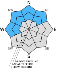
Near and above treeline, CONSIDERABLE avalanche danger will exist with pockets of HIGH danger on leeward W-NW-N-NE-E facing slopes.
Below treeline, expect MODERATE avalanche danger with pockets of CONSIDERABLE on W-NW-N-NE aspects.


Avalanche Problem 1: Persistent Slab
-
Character ?

-
Aspect/Elevation ?
-
Likelihood ?CertainVery LikelyLikelyPossible
 Unlikely
 -
Size ?HistoricVery LargeLargeSmall

Buried surface hoar is a dangerous and scary avalanche problem. We have high uncertainty where surface hoar has been preserved over the past few days. Observations of the best preservation has been on northerly aspects from 6,500 to 8,000 feet. It's going to be difficult to discern where buried surface hoar may exist now. Stay off of northerly slopes steeper than 32 degrees near and below treeline. As new snow and wind transported snow builds on top of this layer, the consequences become greater should it release. Do not let your gaurd down just because you are below treeline. Avalanches can still occur in these areas, especially in areas of openly spaced, old growth forest or gladed areas.
Avalanche Problem 2: Wind Slab
-
Character ?

-
Aspect/Elevation ?
-
Likelihood ?CertainVery LikelyLikelyPossible
Unlikely
-
Size ?HistoricVery LargeLargeSmall
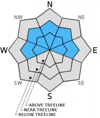
Since the onset of the yesterdays storm, Grey Butte weather station (8,000 feet on Mt Shasta) has recorded average wind speeds of 15-20 mph with gusts 25-35 mph. Wind slabs are certain today and the danger will increase as wind slabs gain size. Moderate southerly winds will quickly deposit snow onto leeward W-NW-N-NE facing slopes today. Slab depths could reach several feet in thickness and become sensitive to trigger. Above treeline, open slope travel is not advised today. Poor visibility and stormy conditions will help keep folks off of these slopes.
Avalanche Problem 3: Storm Slab
-
Character ?

-
Aspect/Elevation ?
-
Likelihood ?CertainVery LikelyLikelyPossible
Unlikely
-
Size ?HistoricVery LargeLargeSmall
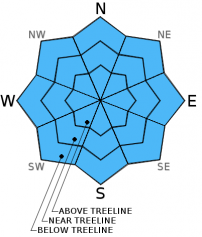
Storm slabs are a soft cohesive layer (slab) of new snow which breaks within the storm snow or on the old snow surface. Storm slabs will be possible on all aspects and all elevations today due to rapid accumulation of snow.
Forecast Discussion
A foggy morning in the valley will give way to mostly cloudy skies and a chance of precipitation later today. Any precip amounts will be light over the next couple of days. A weak ridge will pass over the area late Thursday night into Friday drying out the area briefly before another system arrives Friday night into Saturday. Up to a couple of inches of snow is possible with Friday nights system. Temperatures may be cold enough with this system to snow down to 3,500 ft. In general the next few days will bring some lingering chances of precipitation with some breaks in the clouds Friday and then again on Sunday. Water amounts forecast for today are less than a tenth of an inch (0.05 inches) while Friday looks dry until after 4 pm. The bulk of precipitation associated with Friday nights system falls between 10 pm and 10 am Saturday with close to half an inch of water (0.48 inches). This could translate into 4-6 inches of snow for our area. The remainder of the weekend is dry with no chance of measurable precip until mid-day Monday of next week. Winds will be light today through early tomorrow, then picking up Friday evening with the approaching system.
THIS SEASON PRECIPITATION: Since October 1st (the wet season), we have received 11.76 inches of water, normal is 16.62 inches, putting us at 70% of normal. For the month of January and year of 2016 we've received 2.27 inches of water, normal is 1.41 inches, putting us at 160% of normal
Recent Observations
Yesterday, in a word, was deep. The back to back storm systems over the past couple of days has brought close to two feet of new snow to the area. Combined with the new snow has been moderate winds, and a buried surface hoar layer that formed during the few clear and cold days preceding these systems. This has been a recipe for CONSIDERABLE avalanche danger for elevations near and above treeline with scattered pockets below treeline. Observations made yesterday by both myself and those who ventured out yesterday confirmed these danger ratings as accurate. A report from individual who made it out to Ash Cr Butte outlined their observations at that location in our forecast area. A snow study pit was dug at 7,700 ft. on a north facing aspect with a 30 degree slope angle. Total snow depth at that location was recorded at 235 cm with 65 cm of new snow on the buried surface hoar. An extended column test was performed scoring ECTP23 Q1 at 65 cm deep, sudden planner. A naturally triggered avalanche was also observed off of the same aspect at a higher elevation which ran all the way to the bottom of the bowl traveling 800 vertical feet. Evidence of wind loading and cornice formation were observed above treeline as well.
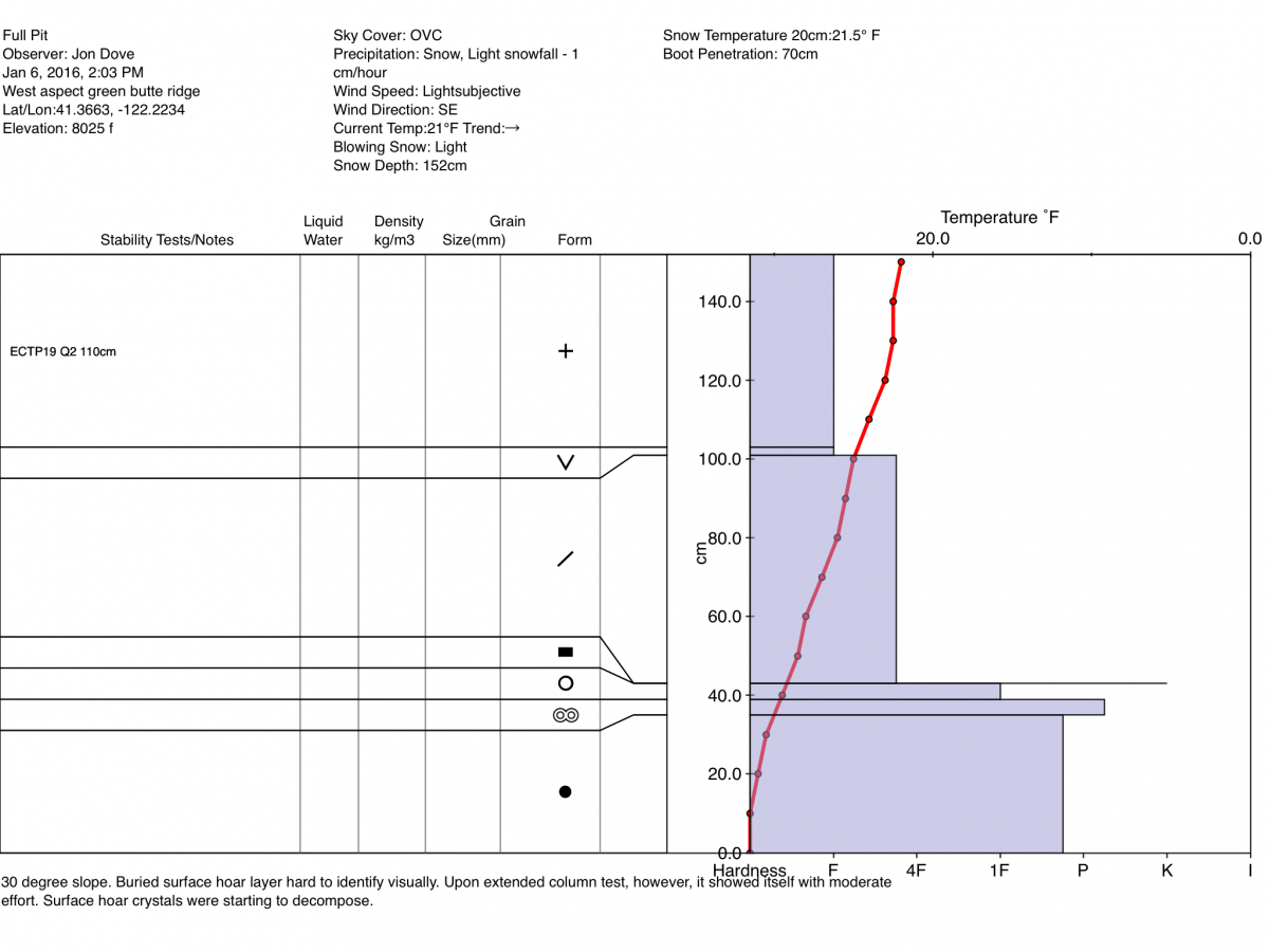
I made a tour yesterday up Green Butte Ridge in search of the buried surface hoar below treeline. Just as you reach the very bottom of Broadway I skinned over to the West aspect that drops from the ridge top into Avalanche Gulch. I dug a snow study pit on that aspect right at 8,000 ft. with a slope angle of 30 degrees. The buried surface hoar was hard to identify visually between the layer of old snow from last weeks storms, and the new snow on top. It wasn't until I performed an extended column test that surface hoar layer presented itself. The results from the EC test was a score of ECTP19 Q2. The surface hoar crystals were easy to identify under a looking glass, but showed signs of decomposition. I believe this persistent weak layer created by the buried surface hoar will remain a problem today on protected W-NW-N-NE aspects at and below treeline. Backcountry skiers/splitboarders/snowmobilers should avoid open slopes of 32 degrees and steeper near and below treeline.
Wind conditions with these most recent storms has been perfect for wind slab formation near and above treeline. Visibility may prevent folks from pushing much above treeline today, but if one were to travel there avoid areas with wind slab formation on leeward W-NW-N-NE-E aspects. Wind has the potential to load leeward slopes 10x faster than falling snow, and creates a more dense layer on top of less dense snow. The high precipitation rates during yesterday's storm combined with steady moderate winds equals increased avalanche danger.
Storm slabs will remain a concern as well as they relate directly to the buried surface hoar PWL avalanche problem. Natural avalanches will be possible and human triggered avalanches will be likely near and above treeline. Below treeline natural avalanches will be unlikely, but human triggered slides will be possible. Safe travel techniques should always be followed, regardless of avalanche danger. Only expose one person at a time to avalanche terrain, regroup in "safe" spots out of avalanche paths, avoid terrain traps, and practice conservative decision making.
1/6/2016-Full Pit Profile by Jon Dove:
____________________________________________________________________________________________________________________________________________________________________
The Sand Flat cross country ski trails are in great shape and ready for your cross country skis or snow shoes. These are backcountry trails marked with blue diamonds on trees. Trails are not groomed. Snow shoers, please blaze a parallel trail to cross country skiers staying out of the skin track. Thank you, and enjoy!
The Pilgrim Creek Snowmobile Park is open! Trails are being groomed currently. Head to our "Education" tab on our website and find the snowmobile section for trail information, grooming status and other sledder resources!
The Five Red Flags of Avalanche Danger any time of year include: 1) Recent/current avalanche activity 2) Whumpfing sounds or shooting cracks 3) Recent/current heavy snowfall 4) Strong winds transporting snow 5) Rapid warming or rain on snow.
Weather and Current Conditions
Weather Summary
Good Morning! In Mt Shasta City at 0500, we have a current temperature of 32 F, 2 degrees cooler than yesterday at this time, foggy.
On Mt Shasta (South Side) in the last 24 hours...
Old Ski Bowl - 7,600 feet, the current temperature is 20 degrees F. Snow on the ground totals 70 inches with 5 inches new snow and no settlement. Temperatures have ranged from 20 F to 23 F.
Grey Butte - 8,000 feet, the current temperature is 19 degrees F. Temperatures have ranged from 19 F to 22 F. Winds have been averaging 11 mph and southerly in direction, with a max gust to 28 mph, SSE.
Mt Eddy Range (West side of Interstate-5)...
Castle Lake - 5,600 feet, the current temperature is 21 degrees F. Temperatures have ranged from 21 F to 28 F. Snow on the ground measures 52 inches with 3 inches new snow and no settlement.
Mt Eddy - 6,500 feet, the current temperature is 17 degrees F. Temperatures have ranged from 17 F to 26 F. Snow on the ground measures 58 inches with 6 inches new snow and 2 inches settlement. Winds have averaged 2 mph Southerly in direction, with a max gust to 15 mph, SW.
Always check the weather before you attempt to climb Mt Shasta. Further, monitor the weather as you climb. Becoming caught on the mountain in any type of weather can compromise life and limb. Be prepared.
| 0600 temperature: | 25 |
| Max. temperature in the last 24 hours: | 27 |
| Average wind direction during the last 24 hours: | Southerly |
| Average wind speed during the last 24 hours: | 10-15 mi/hr |
| Maximum wind gust in the last 24 hours: | 28 mi/hr |
| New snowfall in the last 24 hours: | 4-5 inches |
| Total snow depth: | 70 inches |
Two Day Mountain Weather Forecast
Produced in partnership with the Medford NWS
| For 7000 ft to 9000 ft | |||
|---|---|---|---|
|
Thursday (4 a.m. to 10 p.m.) |
Thursday Night (10 p.m. to 4 a.m.) |
Friday (4 a.m. to 10 p.m.) |
|
| Weather | Cloudy, scattered snow showers. | Mostly cloudy. 40% chance of snow | A chance of snow shower, mainly between 10 am and 4 pm, then a chance of snow after 4 pm. Mostly sunny with increasing clouds. 30% chance of precip. |
| Temperature (°F) | 27 | 20 | 27 |
| Wind (mi/hr) | South 0-5 mph | South/southeast 0-5 mph | South 5-10 mph with higher gusts |
| Precipitation SWE / Snowfall (in) | / 0-.5 | / 0-.5 | / 0-1 |
| For 9000 ft to 11000 ft | |||
| Thursday | Thursday Night | Friday | |
| Weather | Mostly cloudy, scattered snow showers. Wind chill values as low as -3 | Mostly cloudy. 40% chance of snow. Wind chill values as low as -5 | A chance of snow showers mainly between 10 am and 4 pm, then a chance of snow after 4 pm. Mostly sunny with increasing clouds. 30% chance of precip. |
| Temperature (°F) | 12 | 11 | 16 |
| Wind (mi/hr) | Southwest 5-10 mph | West 0-.5 | Southwest 10-15 mph with higher gusts |
| Precipitation SWE / Snowfall (in) | / 0-.5 | / 0-1 | / 1-2 |

