

You are here
Avalanche Advisory for 2016-01-08 07:08:02
- EXPIRED ON January 9, 2016 @ 7:08 amPublished on January 8, 2016 @ 7:08 am
- Issued by Jon Dove - Shasta-Trinity National Forest
Bottom Line
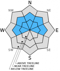
MODERATE avalanche danger exists near and above treeline today on W-NW-N-NE-E aspects steeper than 35 degrees. Human triggered avalanches remain possible due to lingering wind and storm slabs.
LOW avalanche danger exists below treeline.


Avalanche Problem 1: Wind Slab
-
Character ?

-
Aspect/Elevation ?
-
Likelihood ?CertainVery LikelyLikelyPossible
 Unlikely
 -
Size ?HistoricVery LargeLargeSmall

A week of precipitation and southerly wind provided for perfect wind slab formation. While wind slabs have become more difficult to trigger, human triggered wind slab avalanches are possible today near and above treeline. Wind slabs have built up to 3+ feet thick in the usual starting zones below ridge tops and in low lying areas on W-NW-N-NE-E aspects. Wind slabs stability tends to improve over a period of at least a few days and we have observed this. That being said, for those who choose to travel above treeline today, evaluate snow and terrain carefully stopping to identify features of concern. Unsupported snow slopes above cliffs, wind loaded steep couloirs and other complex or extreme terrain will represent the best places to find sensitive wind slabs. Naturally triggered avalanches are unlikely, but human triggered slides are still possible in areas where wind slabs have developed.
Avalanche Problem 2: Storm Slab
-
Character ?

-
Likelihood ?CertainVery LikelyLikelyPossible
Unlikely
-
Size ?HistoricVery LargeLargeSmall
Lingering weaknesses may exist in the recent storm snow or old snow/new snow interface. Continued consolidation should make for difficult to trigger storm slabs however. Slopes steeper than 37 degrees on NW-N-NE facing slopes below and near treeline should be most suspect and could have lingering buried surface hoar behaving like a persistent weak layer. Storm slabs on other aspects are not impossible. Storm slabs have the ability to propagate far and wide. While unlikely today, it's something to keep in mind.
Forecast Discussion
A winter weather advisory issued by the NWS is in effect until 10am this morning. Cloudy skies and scattered snow showers are likely today. Snow levels will remain around 3,500 feet for the Mt Shasta area. Only about a tenth of an inch of water is expected with this storm in progress, so just a dusting in town and a few inches on the mountain already this morning. Most notably will be the high pressure building into the Pacific Northwest late tonight. This will create valley fog and cold low temperatures allowing for good radiational cooling overnight. This could mean more surface hoar forming in our forecast area. The next system set to arrive late Sunday night is very similar to this current one... weakening as it hits shore and producing light precipitation. Expect moderate winds near and above treeline to reside out of the west/southwest this weekend, 20-30 mph, decreasing tonight. Below treeline, winds will be less, 10-20 mph today, decreasing also.
THIS SEASON PRECIPITATION: Since October 1st (the wet season), we have received 11.77 inches of water, normal is 17.10 inches, putting us at 68% of normal. For the month of January and year of 2016 we've received 2.28 inches of water, normal is 1.89 inches, putting us at 120% of normal
Recent Observations
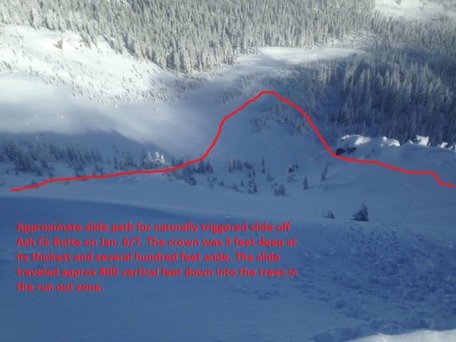
A couple days of warmer temperatures and sunshine continues to consolidate the new storm snow. No further natural or human triggered slides have been reported. An unconfirmed slide on the NW aspect of Gray Butte was mentioned but never confirmed. The largest of observed slides over the recent storm cycle is highlighted below in the east side investigation profile.
The buried surface hoar that has been discussed and was the weak layer in the east side natural avalanche is becoming less of a problem. Protected areas near and below treeline on only the coldest, northerly aspects is where the best preservation has been observed, 6,500 to 8,000 feet. That said, stability tests show either no failure at the layer of buried surface hoar, or requiring moderate to heavy effort. Under the microscope, surface hoar crystals are breaking down and we don't see it as a continued persistent weak layer.
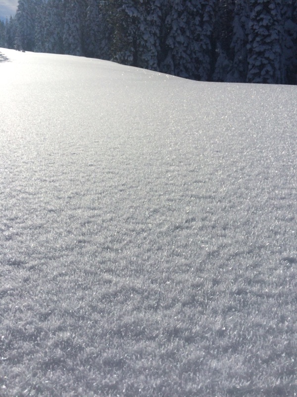
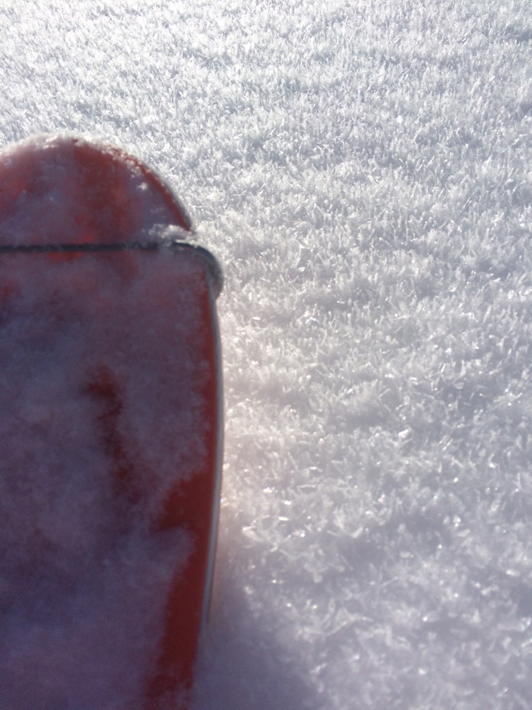
More surface hoar developed the night of the 7th and 8th and photos below show this from the Castle Lake area, northerly aspects, up from the Vista Point. Surface hoar at this point is simply fun to ski!
Ridge lines on Mt Shasta are scoured with rocks showing. Most snow lies in the gullies and depressions of the mountain. Castle Lake and Mt Eddy areas are hosting a good snowpack. Watch out for cornices along the north side of the ridgeline above Castle/Heart Lake.
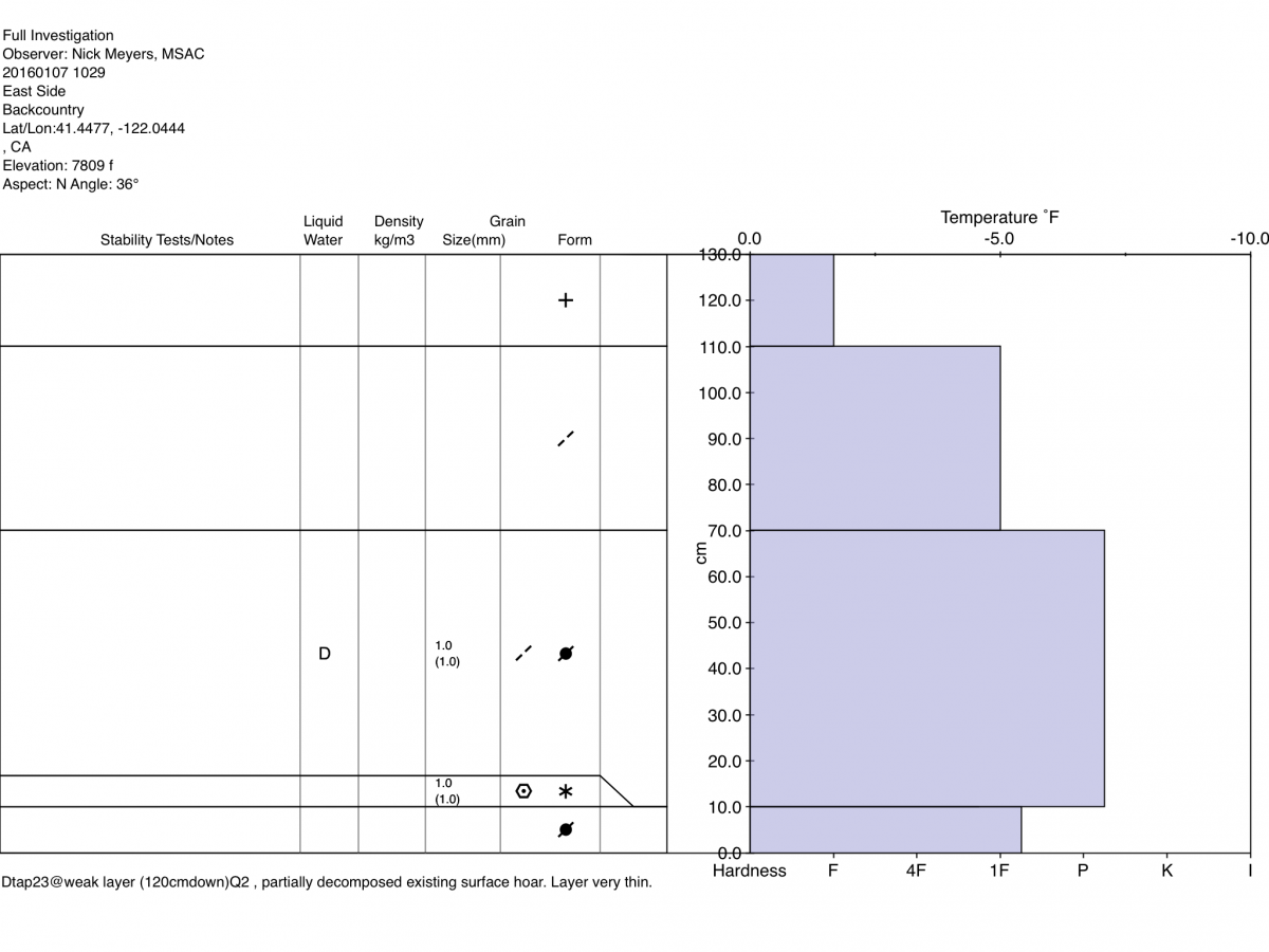
Below: Avalanche investigation profile from a north facing slope east of Mt Shasta with photo of slide path. Heavy precipitation and heavy wind loading on a pocket of existing surface hoar created this good size naturally triggered slide sometime on Jan 6/7.
Below: Surface hoar observed on northerly aspects in the Castle Lake area yesterday, 1.8.16
____________________________________________________________________________________________________________________________________________________________________
The Sand Flat cross country ski trails are in great shape and ready for your cross country skis or snow shoes. These are backcountry trails marked with blue diamonds on trees. Trails are not groomed. Snow shoers, please blaze a parallel trail to cross country skiers staying out of the skin track. These trails can be accessed via the Everitt Memorial Highway. Thank you, and enjoy!
The Mt Shasta Nordic Center is open! These beautiful, groomed trails can be accessed via the Ski Park Highway. http://www.mtshastanordic.org
The Pilgrim Creek Snowmobile Park is open! Trails are being groomed currently. Head to our "Education" tab on our website and find the snowmobile section for trail information, grooming status and other sledder resources!
The Castle Lake road is plowed to the Vista Point. The Everitt Memorial Highway is plowed to Bunny Flat.
The Five Red Flags of Avalanche Danger any time of year include: 1) Recent/current avalanche activity 2) Whumpfing sounds or shooting cracks 3) Recent/current heavy snowfall 4) Strong winds transporting snow 5) Rapid warming or rain on snow.
Weather and Current Conditions
Weather Summary
Good Morning! In Mt Shasta City at 0500, we have a current temperature of 34 F, 4 degrees warmer than yesterday at this time, obscured skies with a dusting of snow on the ground.
On Mt Shasta (South Side) in the last 24 hours...
Old Ski Bowl - 7,600 feet, the current temperature is 21 degrees F. Snow on the ground totals 68 inches with 2 inches new snow and 1 inche settlement. Temperatures have ranged from 15 F to 31 F.
Grey Butte - 8,000 feet, the current temperature is 19 degrees F. Temperatures have ranged from 16 F to 31 F. Winds have been averaging 10 mph, easterly for most of yesterday and primarily southwest last night, with a max gust to 21 mph, both east and southwest.
Mt Eddy Range (West side of Interstate-5)...
Castle Lake - 5,600 feet, the current temperature is 25 degrees F. Temperatures have ranged from 22 F to 30 F. Snow on the ground measures 51 inches with 2 inches new snow and 2 inches of settlement.
Mt Eddy - 6,500 feet, the current temperature is 24 degrees F. Temperatures have ranged from 15 F to 27 F. Snow on the ground measures 57 inches with 1 inch new snow and 1 inch of settlement. Winds have averaged 1-2 mph and southwest in direction, with a max gust to 11 mph, south.
Always check the weather before you attempt to climb Mt Shasta. Further, monitor the weather as you climb. Becoming caught on the mountain in any type of weather can compromise life and limb. Be prepared.
| 0600 temperature: | 23 |
| Max. temperature in the last 24 hours: | 27 |
| Average wind direction during the last 24 hours: | East, then Southwest |
| Average wind speed during the last 24 hours: | 5-10 mi/hr |
| Maximum wind gust in the last 24 hours: | 21 mi/hr |
| New snowfall in the last 24 hours: | 1-3 inches |
| Total snow depth: | 68 inches |
Two Day Mountain Weather Forecast
Produced in partnership with the Medford NWS
| For 7000 ft to 9000 ft | |||
|---|---|---|---|
|
Friday (4 a.m. to 10 p.m.) |
Friday Night (10 p.m. to 4 a.m.) |
Saturday (4 a.m. to 10 p.m.) |
|
| Weather | Snow, chance of precip 80% | Snow showers, 40% chance, mainly before 10pm | Sunny |
| Temperature (°F) | 30 | 18 | 34 |
| Wind (mi/hr) | South 10-20 mph | South/Southeast 5-10 mph | Southeast 5-10 mph |
| Precipitation SWE / Snowfall (in) | / 1-2 | / 0-.5 | / 0 |
| For 9000 ft to 11000 ft | |||
| Friday | Friday Night | Saturday | |
| Weather | Snow, windy, chance of precipitation 100% | A 40% chance of showers, mainly before 10pm, partly cloudy, clearing | Sunny and windy |
| Temperature (°F) | 1-3 | 0-.5 | 0 |
| Wind (mi/hr) | West/Southwest 10-20 mph | West 1-3 | West 20-30 mph, decreasing |
| Precipitation SWE / Snowfall (in) | / 1-3 | / 0-.5 | / 0 |

