

You are here
Avalanche Advisory for 2016-01-10 06:56:00
- EXPIRED ON January 11, 2016 @ 6:56 amPublished on January 10, 2016 @ 6:56 am
- Issued by Nick Meyers - Shasta-Trinity National Forest
Bottom Line
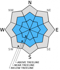
MODERATE avalanche danger exists near and above treeline on all aspects. Human triggered wind and storm slabs and loose-dry snow avalanches on slopes steeper than 35 degrees are possible today.
LOW avalanche danger exists below treeline.


Avalanche Problem 1: Wind Slab
-
Character ?

-
Aspect/Elevation ?
-
Likelihood ?CertainVery LikelyLikelyPossible
 Unlikely
 -
Size ?HistoricVery LargeLargeSmall

Wind slabs have become difficult to trigger. That being said, for those who choose to travel above treeline today, evaluate snow and terrain carefully stopping to identify possible wind slabs. Lingering wind slabs and newly formed slabs on the upper mountain will represent the primary hazard for travel on Mt Shasta or above treeline areas at Castle Lake or Mt Eddy. Unsupported snow slopes above cliffs, wind loaded steep couloirs and other complex or extreme terrain will represent the best places to find sensitive wind slabs. Naturally triggered avalanches are unlikely, but human triggered slides are still possible in areas where wind slabs have developed.
Avalanche Problem 2: Storm Slab
-
Character ?

-
Aspect/Elevation ?
-
Likelihood ?CertainVery LikelyLikelyPossible
Unlikely
-
Size ?HistoricVery LargeLargeSmall
Weaknesses may exist in the recent storm snow or old snow/new snow interface. Some sun today will help consolidate the snowpack and make for difficult to trigger storm slabs however. Slopes steeper than 37 degrees on NW-N-NE facing slopes below and near treeline should be most suspect and could have lingering buried surface hoar behaving like a persistent weak layer. Storm slabs on other aspects are not impossible. Storm slabs have the ability to propagate far and wide. While unlikely, it's something to keep in mind as consequences can be severe.
Avalanche Problem 3: Loose Dry
-
Character ?

-
Aspect/Elevation ?

-
Likelihood ?CertainVery LikelyLikelyPossible
Unlikely
-
Size ?HistoricVery LargeLargeSmall
Three to eight inches of light density snow fell over the forecast area over the past 24 hours. Yesterday, small loose dry snow surface sloughs were observed while riding in the Old Ski Bowl area on slopes steeper than 35 degrees. These avalanches typically occur within layers of soft snow near the surface of the snowpack. While usually harmless, loose dry avalanches can entrain more snow as they move downhill and potentially sweep a rider off their feet and into terrain traps, over a cliff, into trees. These type of slides are more prevalent at higher elevations and on slopes steeper than 35 degrees. Slopes with a long, consistent fetch are most dangerous as they host a long area for a lot of snow to become entrained as it moves downhill.
Forecast Discussion
Slightly cooler temperatures this morning in Mt Shasta City and in the area... Partly cloudy to sunny skies for today will be short lived as an upper level trough makes its way onshore late tonight and tomorrow. This system will mimic the previous system. If that is the case, this is good news as I think many were surprised by the near constant snowfall yesterday at Bunny Flat resulting in a light and fluffy 5-8 inches over the course of the day! Precipitation amounts were almost 4 times the predicted amount. Ha! So, a brief respite today, another system tomorrow and a couple more over the week. Winds will remain mellow today and then begin to pick up tomorrow out of the west/southwest. Approximately .15 inches of water is forecast for Monday with snow levels near 3,500 feet.
THIS SEASON PRECIPITATION: Since October 1st (the wet season), we have received 11.94 inches of water, normal is 17.35 inches, putting us at 68% of normal. For the month of January and year of 2016 we've received 2.45 inches of water, normal is 2.14 inches, putting us at 114% of normal
Recent Observations
The MSAC hosted their second Companion Rescue clinic of the season yesterday at Bunny Flat. The morning started out with some beautiful, light snow. And then it kept snowing, and snowing, and snowing! By the end of the day, 5-8 inches of light density snow piled up for a modest crowd enjoying many forms of winter recreation. Overall, a "right side up" snowpack exists. Avalanche problems today will be confined to the new snow over the past week.
From the Old Ski Bowl area, very light wind was observed with a smooth, consistent and uniform layer of new snow, both from the storm snow over the week and the 5-8 inches of new snow that fell yesterday. The new snow was very light density and some dry-loose surface sloughing was encountered on steeper slopes, >35 degrees.
At Castle Lake, "howling southerly winds" were reported along the ridgeline above of the Castle and Heart Lakes. Cornice formation along the ridgeline was noted. Yesterday we posted some pictures of surface hoar that had formed on northerly aspects in the Castle Lake area. New snow totals of only a few inches on top of the surface hoar will not provide for major avalanche danger. Steeper slopes one will encounter small to medium size surface sloughing, point release style slides.
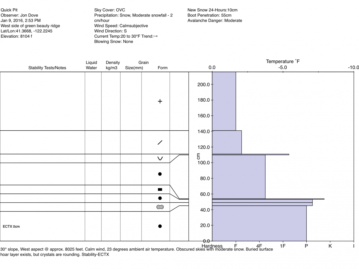
Along Green Butte Ridge, a snow data pit (below) was excavated near an area where some existing buried surface hoar has been observed. Stability tests did not produce unstable results and the buried weak layer of mention this past week is healing well.
_______________________________________________________________________________________________________________________________________________________
LOCAL AREA ROAD, NORDIC and SNOWMOBILE PARK STATUS:
The Sand Flat cross country ski trails are in great shape and ready for your cross country skis or snow shoes. These are backcountry trails marked with blue diamonds on trees. Trails are not groomed. Snow shoers, please blaze a parallel trail to cross country skiers staying out of the skin track. These trails can be accessed via the Everitt Memorial Highway. Thank you, and enjoy!
The Mt Shasta Nordic Center is open! These beautiful, groomed trails can be accessed via the Ski Park Highway. http://www.mtshastanordic.org
The Pilgrim Creek & Deer Mountain Snowmobile Parks are open! Trails are being groomed currently. Head to our "Education" tab on our website and find the snowmobile section for trail information, grooming status and other sledder resources!
The Castle Lake road is plowed to the Vista Point. The Everitt Memorial Highway is plowed to Bunny Flat.
The Five Red Flags of Avalanche Danger any time of year include: 1) Recent/current avalanche activity 2) Whumpfing sounds or shooting cracks 3) Recent/current heavy snowfall 4) Strong winds transporting snow 5) Rapid warming or rain on snow.
Weather and Current Conditions
Weather Summary
Good Morning! In Mt Shasta City at 0500, we have a current temperature of 32 F, 2 degrees cooler than yesterday at this time, with a dusting of snow on the ground.
On Mt Shasta (South Side) in the last 24 hours...
Old Ski Bowl - 7,600 feet, the current temperature is 20 degrees F. Snow on the ground totals 76 inches with 8 inches new snow and no settlement. Temperatures have ranged from 16 F to 24 F.
Grey Butte - 8,000 feet, the current temperature is 21 degrees F. Temperatures have ranged from 19 F to 21 F. Winds have been averaging 7 mph out of the WSW and then out of the ESE since midnight. A max gust early yesterday morning reached 21 mph.
Mt Eddy Range (West side of Interstate-5)...
Castle Lake - 5,600 feet, the current temperature is 26 degrees F. Temperatures have ranged from 24 F to 31 F. Snow on the ground measures 53 inches with 3-5 inches new snow and 1 inch settlement.
Mt Eddy - 6,500 feet, the current temperature is 20 degrees F. Temperatures have ranged from 19 F to 29 F. Snow on the ground measures 59 inches with 3-5 inches new snow and 1 inch of settlement. Winds have averaged 1-2 mph and southeast in direction, with a max gust to 9 mph, south.
Always check the weather before you attempt to climb Mt Shasta. Further, monitor the weather as you climb. Becoming caught on the mountain in any type of weather can compromise life and limb. Be prepared.
| 0600 temperature: | 19 |
| Max. temperature in the last 24 hours: | 27 |
| Average wind direction during the last 24 hours: | West/Southwest |
| Average wind speed during the last 24 hours: | 3-7 mph mi/hr |
| Maximum wind gust in the last 24 hours: | 21 mi/hr |
| New snowfall in the last 24 hours: | 5-8 inches |
| Total snow depth: | 67 inches |
Two Day Mountain Weather Forecast
Produced in partnership with the Medford NWS
| For 7000 ft to 9000 ft | |||
|---|---|---|---|
|
Sunday (4 a.m. to 10 p.m.) |
Sunday Night (10 p.m. to 4 a.m.) |
Monday (4 a.m. to 10 p.m.) |
|
| Weather | Sunny | A 30% chance of snow after 4am. Increasing clouds | Snow, mainly after 10am |
| Temperature (°F) | 33 | 24 | 33 |
| Wind (mi/hr) | Southeast 5-10 mph | Southeast 10-15 mph | South/Southeast 10-20 mph |
| Precipitation SWE / Snowfall (in) | / 0 | / 0-.5 | / 0-1 |
| For 9000 ft to 11000 ft | |||
| Sunday | Sunday Night | Monday | |
| Weather | Sunny | A 30% chance of snow after 4am. Increasing clouds. Breezy | Snow, mainly after 10am, windy |
| Temperature (°F) | 23 | 23 | 25 |
| Wind (mi/hr) | South 10-15 mph | South/Southwest 0 | West/Southwest 20-30 mph with gusts to 40-50 mph |
| Precipitation SWE / Snowfall (in) | / 0 | / 0-.5 | / 1-3 |

