

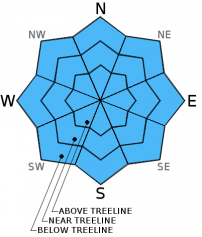
You are here
Avalanche Advisory for 2016-01-11 07:09:40
- EXPIRED ON January 12, 2016 @ 7:09 amPublished on January 11, 2016 @ 7:09 am
- Issued by Nick Meyers - Shasta-Trinity National Forest
Bottom Line
MODERATE avalanche danger exists near and above treeline on NW-N-NE aspects steeper than 35 degrees. Human triggered, small wind and storm slabs and loose-dry snow avalanches are possible today.
LOW avalanche danger exists below treeline.


Avalanche Problem 1: Storm Slab
-
Character ?

-
Aspect/Elevation ?
-
Likelihood ?CertainVery LikelyLikelyPossible
 Unlikely
 -
Size ?HistoricVery LargeLargeSmall

Avalanche problems today will be confined to the new snow. Rather than list several different ones, I'll lump them together under the storm slab avalanche problem.
1. Winds have been relatively calm. Watch for minor wind loading and/or existing small to medium size wind slabs on ridgetops or where isolated wind slabs are noted. A skier or rider would have to hit just the right spot to trigger a wind slab and while unlikely, there are probably a few out there that could be set loose. Unsupported snow slopes above cliffs, wind loaded steep couloirs and other complex or extreme terrain will represent the best places to find sensitive wind slabs. New snow today is expected to be only a few inches at best and will not cause any additional avalanche concerns.
2. Light density snow that fell over the forecast area during our last storm over the weekend will slough very easily on northerly slopes steeper than 35 degrees, all elevations. It is possible for sloughs to trigger minor soft slabs which could break over a wider area where light wind has created soft slab properties. Remember, a slab only needs to be slightly stronger and more cohesive than the weak layer or less dense snow under it to cause a slab avalanche. Sloughs, while usually harmless, can certainly sweep a rider off their feet and into terrain traps, into a tree, over a cliff, etc.
3. South aspects may have some avalanche activity in the new snow, mainly sloughs and point releases. It's likely however that clouds and new snow will limit this action.
Forecast Discussion
A wet and windy week is in store for the Mt Shasta area and will begin today with a small system similar to the last one we received. We should see mostly cloudy skies today with a chance of snow this morning and snow likely this afternoon, snow levels near 4,300 feet today and 5,500 feet tonight. We won't see the snow level lower much more until Wednesday as warm air enters the area. Precipitation amounts out of this first round are less than .10", however that's what was predicted for the last storm and we received about four times that amount. So.. we'll have to see... south/southwest flow is always favorable for Mt Shasta.
High winds associated with the "main event" are expected Tuesday afternoon into Wednesday morning. A large scale trough that has lurked over the Pacific will finally make a run for land and bring over .5" of water to the area, which could mean another 6 inches of new snow, perhaps more! Wednesday, snow levels will drop to 4,700 feet. High winds with new snow always point to new wind slab formation. Further, heavier snow on top of our light density snow that now sits on the snow surface is a recipe for an upside down cake snowpack and avalanches probable.
THIS SEASON PRECIPITATION: Since October 1st (the wet season), we have received 11.94 inches of water, normal is 17.60 inches, putting us at 67% of normal. For the month of January and year of 2016 we've received 2.45 inches of water, normal is 2.39 inches, putting us at 102% of normal
Recent Observations
Overall, a "right side up" snowpack exists for all areas and any instabilities have been limited to the top layers of the snowpack. Numerous small to medium size point release avalanches, roller balls and surface sloughs from ski cuts were observed yesterday on the west side of the forecast area, both in the Cliff Lake and Castle Lake area. Two snow pits were dug and results are below. Avalanche problems today will continue to be confined to the new snow in the top layers of the snowpack. Lingering buried surface hoar continues to metamorphose to rounded snow grains and this weak layer is not a concern at this time. Some newly formed surface hoar has formed in the Castle Lake area and will not be a concern until we get significant snow on top and by that time, it's likely the SH will be broken down.
Yesterdays sunshine helped consolidate the snowpack. We observed surface sloughing on northerly aspects and roller balls due to solar heating on southerly aspects. South aspects that received solar heating yesterday may have a bit of a sun crust at lower elevations today. Northerly aspects we'll likely seeing continued surface sloughing on slopes steeper than 37 degrees.
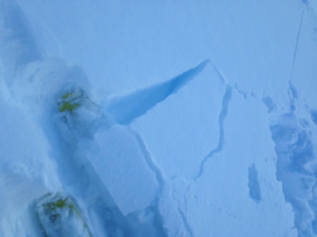
A couple larger point release slides were observed on the mountain off of Casaval Ridge and running into Avalanche Gulch, east/southeast facing yesterday. Slopes with a long fetch, such as on Mt Shasta, represent the greatest danger for loose snow surface sloughs as these long, continuous slopes allow for a lot of snow to become entrained as the avalanche moves downhill and gains speed.
Large cornices were noted along ridgelines on the west side. Cornices were easily triggered and initiated surface sloughing on slopes below, though no propagation.
Isolated areas where the snow received light wind, slab properties were best and some cracking of the snowpack was observed, though widespread slab formation not prevalent.
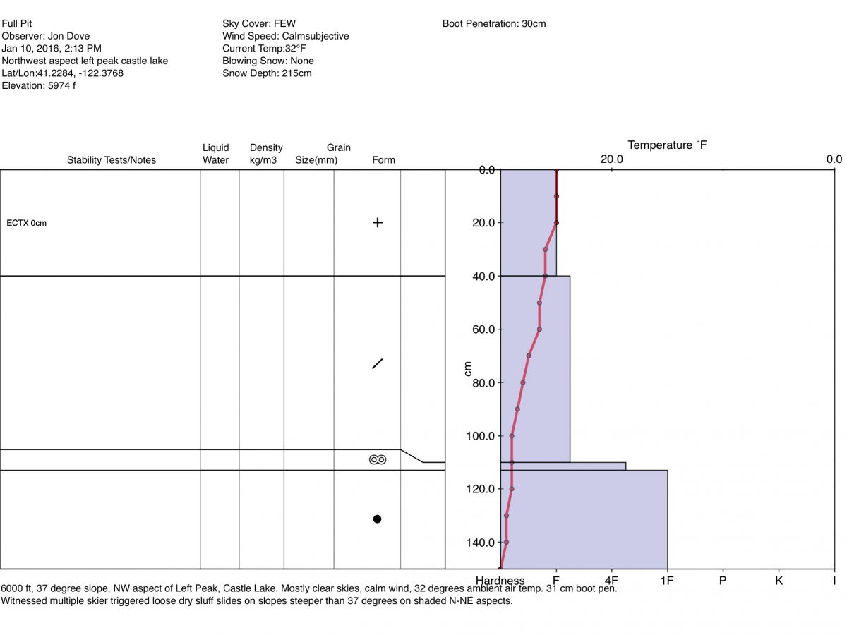
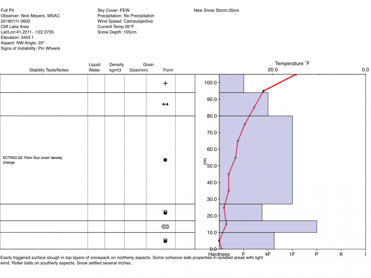
Pits from the west side of the forecast area.
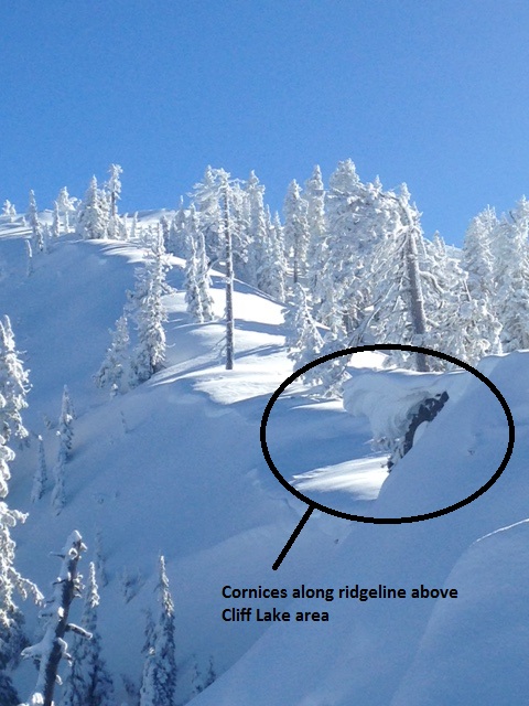
Cliff Lake area, 1.11.16
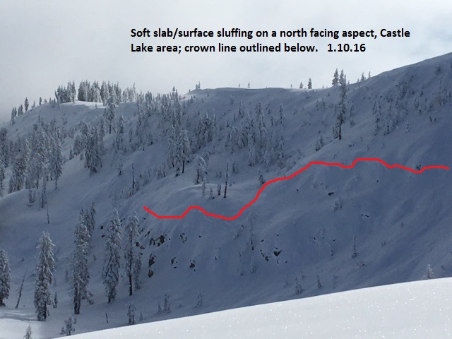
Castle Lake area, north facing, 1.11.16
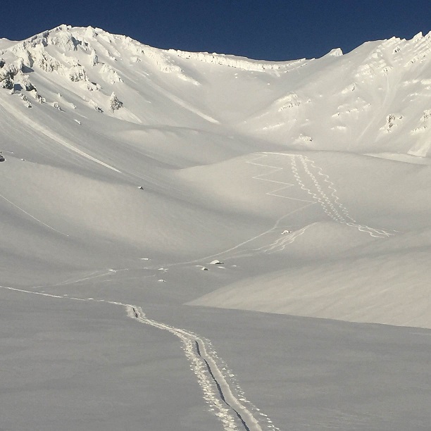
Avalanche Gulch, 1.11.16 Photo: Rathbun
______________________________________________________________________________________________________________________________________________________
LOCAL AREA ROAD, NORDIC and SNOWMOBILE PARK STATUS:
The Sand Flat cross country ski trails are in great shape and ready for your cross country skis or snow shoes. These are backcountry trails marked with blue diamonds on trees. Trails are not groomed. Snow shoers, please blaze a parallel trail to cross country skiers staying out of the skin track. These trails can be accessed via the Everitt Memorial Highway. Thank you, and enjoy!
The Mt Shasta Nordic Center is open! These beautiful, groomed trails can be accessed via the Ski Park Highway. http://www.mtshastanordic.org
The Pilgrim Creek & Deer Mountain Snowmobile Parks are open! Trails are being groomed currently. Head to our "Education" tab on our website and find the snowmobile section for trail information, grooming status and other sledder resources!
The Castle Lake road is plowed to the Vista Point. The Everitt Memorial Highway is plowed to Bunny Flat.
The Five Red Flags of Avalanche Danger any time of year include: 1) Recent/current avalanche activity 2) Whumpfing sounds or shooting cracks 3) Recent/current heavy snowfall 4) Strong winds transporting snow 5) Rapid warming or rain on snow.
Weather and Current Conditions
Weather Summary
Good Morning! In Mt Shasta City at 0500, we have a current temperature of 36 F, 4 degrees warmer than yesterday at this time, with obscured skies and calm winds.
On Mt Shasta (South Side) in the last 24 hours...
Old Ski Bowl - 7,600 feet, the current temperature is 26 degrees F. Snow on the ground totals 74 inches with no new snow and 2 inches settlement. Temperatures have ranged from 18 F to 29 F.
Grey Butte - 8,000 feet, the current temperature is 23 degrees F. Temperatures have ranged from 20 F to 27 F. Winds have been averaging 10-15 mph primarily out of the ESE and then out of the WSW since midnight. A max gust reached 21 mph both from WSW and ESE.
Mt Eddy Range (West side of Interstate-5)...
Castle Lake - 5,600 feet, the current temperature is 28 degrees F. Temperatures have ranged from 24 F to 31 F. Snow on the ground measures 52 inches with no new snow and 1 inch settlement.
Mt Eddy - 6,500 feet, the current temperature is 28 degrees F. Temperatures have ranged from 20 F to 31 F. Snow on the ground measures 58 inches with no new snow and 1 inch of settlement. Winds have averaged 2 mph and southeast in direction, with a max gust to 11 mph, southeast.
Always check the weather before you attempt to climb Mt Shasta. Further, monitor the weather as you climb. Becoming caught on the mountain in any type of weather can compromise life and limb. Be prepared.
| 0600 temperature: | 27 |
| Max. temperature in the last 24 hours: | 28 |
| Average wind direction during the last 24 hours: | East/Southeast |
| Average wind speed during the last 24 hours: | 5-10 mi/hr |
| Maximum wind gust in the last 24 hours: | 21 mi/hr |
| New snowfall in the last 24 hours: | 0 inches |
| Total snow depth: | 64 inches |
Two Day Mountain Weather Forecast
Produced in partnership with the Medford NWS
| For 7000 ft to 9000 ft | |||
|---|---|---|---|
|
Monday (4 a.m. to 10 p.m.) |
Monday Night (10 p.m. to 4 a.m.) |
Tuesday (4 a.m. to 10 p.m.) |
|
| Weather | Snow likely, mainly after 10am, mostly cloudy, chance of precip 60% | Chance of snow showers before 10pm, then chance of snow after am, mostly cloudy, chance of precip 30% | Snow, mainly after 10am, chance of precip 80% |
| Temperature (°F) | 31 | 27 | 32 |
| Wind (mi/hr) | South/Southeast 10-15 mph | South/Southeast 10-15 mph | South/Southeast 10-20 mph |
| Precipitation SWE / Snowfall (in) | / 0-.5 | / 0-.5 | / 1-2 |
| For 9000 ft to 11000 ft | |||
| Monday | Monday Night | Tuesday | |
| Weather | Snow likely, mainly after 10am, mostly cloudy, chance of precip 70% | A chance of snow showers before 10pm, then a chance of snow after 4am, mostly cloudy, chance of precip 30% | Snow, mainly after 10am, windy, chance of precip 80% |
| Temperature (°F) | 24 | 23 | 25 |
| Wind (mi/hr) | West/Southwest 25-35 mph | Southwest 0-.5 | Southwest 35-45 mph, decreasing in the afternoon. Gusts could reach 60-70 mph. |
| Precipitation SWE / Snowfall (in) | / 0-.5 | / .5 | / 1-2 |

