

You are here
Avalanche Advisory for 2016-01-13 07:04:13
- EXPIRED ON January 14, 2016 @ 7:04 amPublished on January 13, 2016 @ 7:04 am
- Issued by Jon Dove - Shasta-Trinity National Forest
Bottom Line
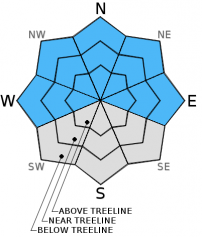
MODERATE avalanche danger exists for all elevations and aspects this morning with pockets of CONSIDERABLE on wind loaded W-NW-N-NE-E aspects. There is a winter weather advisory in effect until this afternoon with hurricane force winds at mid-mountain (10,000 ft.) locations Thursday. Heavier snow over light snow will exist at near and below treeline locations making wind and storm slabs more prone to failure. Evaluate snow and terrain carefully. Cautious route finding and decision making will be essential.


Avalanche Problem 1: Wind Slab
-
Character ?

-
Aspect/Elevation ?
-
Likelihood ?CertainVery LikelyLikelyPossible
 Unlikely
 -
Size ?HistoricVery LargeLargeSmall

Wind slab avalanche danger has increased with the moderate to strong southerly winds associated with this storm system. Small to large wind slabs have formed on leeward W-NW-N-NE-E facing slopes. Strong winds have scoured ridge tops and have loaded both typical and non-typical areas such as mid-slope starting zones. All terrain, near and above treeline, should be considered dangerous during and immediately after this storm. Conditions will prevent any travel above treeline today, however it is immediately after the storm when skiers and riders venture above treeline and wind slabs could remain sensitive. Open, unsupported snow slopes above cliffs, wind loaded steep chutes and couloirs, and other complex or extreme terrain will represent the best places to find sensitive wind slabs today. Avoid travel on or below slopes of 32 degrees and steeper on leeward aspects near and above treeline.
Avalanche Problem 2: Storm Slab
-
Character ?

-
Aspect/Elevation ?
-
Likelihood ?CertainVery LikelyLikelyPossible
Unlikely
-
Size ?HistoricVery LargeLargeSmall
Storm slabs will be at there most sensitve in areas near and below treeline, especially in more northerly facing aspects where we have had the development of denser snow over softer snow. The increase in temperature over the last couple of days raised the snow levels to around 7,200 ft.
Forecast Discussion
As noted yesterday strong winds have been, and will continue to be, a hallmark of storm activity both today and tomorrow. Winds will decrease as the remainder of today's storm system passes, then increasing after midnight with the next front. Winds will be there strongest at above treeline, mid-mountain (10,000 ft) locations with wind gusts to 70+ mph (near hurricane force). Visibility, however, will prevent anyone from venturing that far. Rain and snow showers (depending on elevation) will begin to tapper off late this afternoon as a weak upper level ridge builds over the area. The next frontal system will begin to charge through Thursday morning at the head of a strong jet stream. Snow levels will drop during the day today to around 4,000 ft. as cold air trails behind the current storm system. Snow fall totals will be between 6-8 inches in protected areas near and below treeline. Winds will transport new snow above treeline scouring ridge tops and exposed areas, and depositing snow on leeward W-NW-N-NE-E aspects. Another weak ridge will build behind Thursday's storm mirroring today's weather pattern.
THIS SEASON PRECIPITATION: Since October 1st (the wet season), we have received 12.63 inches of water, normal is 18.10 inches, putting us at 69% of normal. For the month of January and year of 2016 we've received 3.14 inches of water, normal is 2.89 inches, putting us at 108% of normal
Recent Observations
The warming trend experienced yesterday had an interesting effect on the upper portion of the snowpack. Temperatures warmed to near or just above freezing at elevations up to 7,200 ft. It created a layer of wetter, denser snow on top of softer snow. Even more northerly facing aspects were affected with a more defined difference in density change. This will present an interesting combination of conditions today considering the significant amount of new snow (storm slab) that is now resting on top of this dense layer with softer snow beneath. The interface of the more consolidated snow with the soft snow underneath will be the one to watch out for today, especially in wind loaded areas (W-NW-N-NE-E aspects) near treeline.
Observations made yesterday at Deadfall Lake, which sits at an elevation of 7260 ft., confirmed the development of denser snow over softer snow in the top 30 cm of the snowpack. This made for some challenging conditions for snowmobilers, and less than ideal conditions for skiers. An extended column test was performed resulting in a score of ECTX. That being said, the addition of 18-20 new cm on top of this dense layer will test the stress vs strength ratio, especially on more northerly facing aspects. The interface between the dense snow over slightly softer snow (4Finger- over Fist) was the location of failure when a shovel shear test was performed on the column after ECT. This interface will be suspect with the additional weight of the new snow.
Instabilities in the snowpack have been few and none were observed yesterday. Loose sloughs and roller ball activity will be put on hold for now and we currently are most focused on the current and expected storms. This storm has raised the avalanche danger and put wind and storm slabs as the top avalanche problems. Heavy precipitation rates with very windy conditions have created new, potentially large wind and storm slabs. Careful terrain and snowpack evaluation, cautious route finding, and conservative decision making will be essential today. Avoid travel over or underneath wind loaded leeward W-NW-N-NE-E aspects 32 degrees and steeper near and above treeline.
______________________________________________________________________________________________________________________________________________________
LOCAL AREA ROAD, NORDIC and SNOWMOBILE PARK STATUS:
The Sand Flat cross country ski trails are in great shape and ready for your cross country skis or snow shoes. These are backcountry trails marked with blue diamonds on trees. Trails are not groomed. Snow shoers, please blaze a parallel trail to cross country skiers staying out of the skin track. These trails can be accessed via the Everett Memorial Highway. Thank you, and enjoy!
The Mt Shasta Nordic Center is open! These beautiful, groomed trails can be accessed via the Ski Park Highway. http://www.mtshastanordic.org
The Pilgrim Creek & Deer Mountain Snowmobile Parks are open! Trails are being groomed currently. Head to our "Education" tab on our website and find the snowmobile section for trail information, grooming status and other sledder resources!
The Castle Lake road is plowed to the Vista Point. The Everett Memorial Highway is plowed to Bunny Flat.
The Five Red Flags of Avalanche Danger any time of year include: 1) Recent/current avalanche activity 2) Whumpfing sounds or shooting cracks 3) Recent/current heavy snowfall 4) Strong winds transporting snow 5) Rapid warming or rain on snow.
Weather and Current Conditions
Weather Summary
Good Morning! In Mt Shasta City at 0500, we have a current temperature of 38 F, the same as yesterday at this time, with cloudy skies and light to moderate rain.
On Mt Shasta (South Side) in the last 24 hours...
Old Ski Bowl - 7,600 feet, the current temperature is 24 degrees F. Snow on the ground totals 79 inches with 7 inches new snow and no settlement. Temperatures have ranged from 24 F to 30 F.
Grey Butte - 8,000 feet, the current temperature is 25 degrees F. Temperatures have ranged from 25 F to 29 F. Winds have been averaging 15-20 mph and southerly in nature with a max gust to 42 mph, SSW.
Mt Eddy Range (West side of Interstate-5)...
Castle Lake - 5,600 feet, the current temperature is 29 degrees F. Temperatures have ranged from 28 F to 31 F. Snow on the ground measures 56 inches with 6 inches of new snow and no settlement.
Mt Eddy - 6,500 feet, the current temperature is 28 degrees F. Temperatures have ranged from 28 F to 32 F. Snow on the ground measures 63 inches with 7 inches of new snow and no settlement. Winds have averaged 2 mph and southerly in direction, with a max gust to 25 mph, SSW.
Always check the weather before you attempt to climb Mt Shasta. Further, monitor the weather as you climb. Becoming caught on the mountain in any type of weather can compromise life and limb. Be prepared.
| 0600 temperature: | 29 |
| Max. temperature in the last 24 hours: | 33 |
| Average wind direction during the last 24 hours: | Southerly |
| Average wind speed during the last 24 hours: | 15-20 mi/hr |
| Maximum wind gust in the last 24 hours: | 42 mi/hr |
| New snowfall in the last 24 hours: | 7 inches |
| Total snow depth: | 70 inches |
Two Day Mountain Weather Forecast
Produced in partnership with the Medford NWS
| For 7000 ft to 9000 ft | |||
|---|---|---|---|
|
Wednesday (4 a.m. to 10 p.m.) |
Wednesday Night (10 p.m. to 4 a.m.) |
Thursday (4 a.m. to 10 p.m.) |
|
| Weather | Mostly cloudy with snow showers mainly before 4 pm. Breezy | Mostly cloudy with a 30% chance of snow showers, mainly before 10 pm | Cloudy and snow. Windy |
| Temperature (°F) | 33 falling to 25 | 22 | 29 |
| Wind (mi/hr) | South/Southwest 15-20 mph with gusts to 35 mph | West/northwest becoming south after midnight 5-10 mph with occasional higher gusts | South 15-20 mph, increasing to 25-30 mph with gusts to 40 mph |
| Precipitation SWE / Snowfall (in) | / 4-8 | / 0-1 | / 3-7 |
| For 9000 ft to 11000 ft | |||
| Wednesday | Wednesday Night | Thursday | |
| Weather | Mostly cloudy with snow showers, mainly before 4 pm. Snow could be heavy at times. Windy with wind chill values as low as -16. | Mostly cloudy with a 60% chance of snow showers, mainly before 10 pm, then snow likely after 4 am. Windy with wind chill values as low as -19 | Cloudy, snow. Snow could be heavy at times. Windy with wind chill values as low as -11. |
| Temperature (°F) | 13 falling to around 11 | 11 rising to around 17 | 20 |
| Wind (mi/hr) | Southwest 45-50 mph, decreasing to 35-40 mph in the afternoon. Gusts to 70 mph. | West 10-14 | West/southwest 55-65 mph with gusts to 80+ mph |
| Precipitation SWE / Snowfall (in) | / 10-14 | / 0-1 | / 6-10 |

