

You are here
Avalanche Advisory for 2016-01-14 06:58:20
- EXPIRED ON January 15, 2016 @ 6:58 amPublished on January 14, 2016 @ 6:58 am
- Issued by Jon Dove - Shasta-Trinity National Forest
Bottom Line
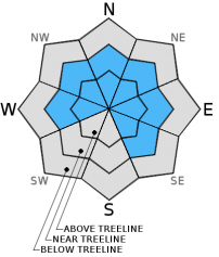
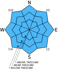
MODERATE avalanche danger exists for all elevations and aspects this morning with CONSIDERABLE avalanche danger on wind loaded W-NW-N-NE-E-SE aspects near and above treeline due to wind slabs and "upside down", heavy over light, snow layers that exist near treeline. Avoid wind loaded slopes 35 degrees and steeper near and above treeline. Cautious route finding and conservative decision making will be essential.


Avalanche Problem 1: Wind Slab
-
Character ?

-
Aspect/Elevation ?
-
Likelihood ?CertainVery LikelyLikelyPossible
 Unlikely
 -
Size ?HistoricVery LargeLargeSmall

Wind slab avalanche danger has increased with the moderate to strong southerly to westerly winds associated with yesterday's storm system. Small to large wind slabs have formed on leeward W-NW-N-NE-E-SE facing slopes. Strong winds have scoured ridge tops and have loaded both typical and non-typical areas such as mid-slope starting zones, depressions around rock outcroppings, etc. All terrain, near and above treeline, should be considered dangerous during and immediately after today's storm. Conditions will prevent much travel above treeline today anyhow. However, it is immediately after the storm when skiers and riders tend to venture above treeline where wind slabs could remain quite sensitive. Open, unsupported snow slopes above cliffs, wind loaded steep chutes and couloirs, and other complex or extreme terrain will represent the best places to find sensitive wind slabs today. Avoid travel on or below slopes of 35 degrees and steeper on leeward aspects near and above treeline.
Avalanche Problem 2: Storm Slab
-
Character ?

-
Aspect/Elevation ?
-
Likelihood ?CertainVery LikelyLikelyPossible
Unlikely
-
Size ?HistoricVery LargeLargeSmall
Storm slabs will be at there most sensitive in areas near and below treeline, especially in more northerly facing aspects where we have had the development of denser snow over softer snow. The increase in temperature at the beginning of the week raised the snow levels to around 7,200 ft. A cooling trend has since dropped snow levels to around 4,500 ft. Storm slabs that have developed with yesterday's storm totals of 10-12 new inches of snow sit on top of an "upside down", dense over less dense, snow layering in the upper snowpack. Added weight from additional snow or a skier/rider could tip the stress vs. strength balance causing an avalanche. Evaluate snow and terrain carefully using cautious route finding and conservative decision making today.
Forecast Discussion
Winds were a powerful force yesterday, especially in the mid to late afternoon. A maximum gust of 85 mph was recorded at Grey Butte weather station at 1700 hours! The outlook for today sees another active winter weather pattern as the current front moves in at the head of a strong jet stream which is aimed at the CA-OR boarder. With a bit cooler air mass today's storm will have snow levels slightly lower than yesterday's system. Snow could fall as low as Mt. Shasta City. A "winter weather advisory" has been issued, and up to .75 inches of water are forecast. This will translate into 6-9 inches of snow for the Mt. Shasta area. Showers will tapper off early Friday morning as a weak upper level ridge builds over the region. This ridge will quickly break down by late Friday as a warm front brings another round of precipitation. The wet weather pattern will continue into the weekend. It is still a few days out, but a storm system forecast for Sunday looks to be "an atmospheric river event and quite wet' according to NOAA meteorologists. Winds will continue to be strong, especially at mid-mountain (10,000 ft.) levels and above coming out of the W-SW. Snow levels for today will hover between 3,500-4000 feet, then begin to rise mid-day Friday with the approaching warm front up to around 7,000 ft.
THIS SEASON PRECIPITATION: Since October 1st (the wet season), we have received 13.65 inches of water, normal is 18.34 inches, putting us at 74% of normal. For the month of January and year of 2016 we've received 4.16 inches of water, normal is 3.13 inches, putting us at 132% of normal
Recent Observations
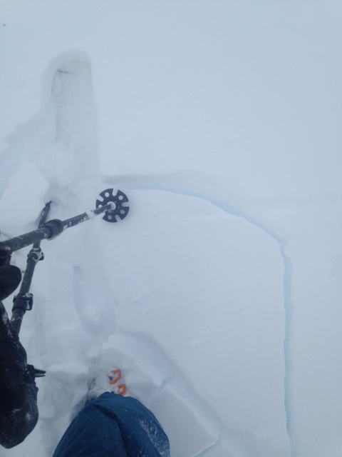
Observations from the field yesterday confirmed suspicions of the impact warming temperatures have had on the upper layers of the snowpack. As noted in yesterday's advisory warming temperatures after the weekend have created a heavier, denser layer of snow over lighter, less dense snow. This "upside down" layering is most pronounced on more northerly facing aspects. A report was given from a tour made up Grey Butte of "whumphing", obvious collapsing (see photo below), and cracking of wind slabs. A prominent sun/rain crust under the new snow was identified on all aspects, southerly aspects especially, up to the rain/snow line around 7,500-8,000 ft. Brutal southwest winds were observed at the top of Grey Butte, as well. A video of the wind event can be viewed at http://www.youtube.com/watch?v=wWB2C35LxTo. It is not certain what layer was collapsing, however, it is assumed it was likely the less dense snow under more dense, wind packed snow.
Yesterday's storm has raised the avalanche danger and put wind and storm slabs as our top avalanche problems. Heavy precipitation rates with very windy conditions have created new, potentially large wind and storm slabs. Both storm slabs and wind slabs will increase in thickness and size with additional snow and high winds that are forecast for later today. The added weight of additional snow and wind loading will increase stress on the snowpack. A skier/rider/snowmobiler could be the right trigger to tip the scale and cause an avalanche. Careful terrain and snowpack evaluation, cautious route finding, and conservative decision making will be essential today. Avoid travel over or underneath wind loaded leeward W-NW-N-NE-E-SE aspects 35 degrees and steeper near and above treeline.
Collapsing accompanied by Whoomphing! on Grey Butte-photo: Nick Meyers
______________________________________________________________________________________________________________________________________________________
LOCAL AREA ROAD, NORDIC and SNOWMOBILE PARK STATUS:
The Sand Flat cross country ski trails are in great shape and ready for your cross country skis or snow shoes. These are backcountry trails marked with blue diamonds on trees. Trails are not groomed. Snow shoers, please blaze a parallel trail to cross country skiers staying out of the skin track. These trails can be accessed via the Everett Memorial Highway. Thank you, and enjoy!
The Mt Shasta Nordic Center is open! These beautiful, groomed trails can be accessed via the Ski Park Highway. http://www.mtshastanordic.org
The Pilgrim Creek & Deer Mountain Snowmobile Parks are open! Trails are being groomed currently. Head to our "Education" tab on our website and find the snowmobile section for trail information, grooming status and other sledder resources!
The Castle Lake road is plowed to the Vista Point. The Everett Memorial Highway is plowed to Bunny Flat.
The Five Red Flags of Avalanche Danger any time of year include: 1) Recent/current avalanche activity 2) Whoomphing sounds or shooting cracks 3) Recent/current heavy snowfall 4) Strong winds transporting snow 5) Rapid warming or rain on snow.
Weather and Current Conditions
Weather Summary
Good Morning! In Mt Shasta City at 0500, we have a current temperature of 27 F, eleven degrees cooler than yesterday at this time, with overcast skies and calm wind.
On Mt Shasta (South Side) in the last 24 hours...
Old Ski Bowl - 7,600 feet, the current temperature is 13 degrees F. Snow on the ground totals 82 inches with 3 inches new snow and 3 inches of settlement. Temperatures have ranged from 13 F to 26 F.
Grey Butte - 8,000 feet, the current temperature is 14 degrees F. Temperatures have ranged from 14 F to 25 F. Winds have been averaging 15-20 mph and westerly in nature with a max gust to 85 mph, NW.
Mt Eddy Range (West side of Interstate-5)...
Castle Lake - 5,600 feet, the current temperature is 21 degrees F. Temperatures have ranged from 19 F to 31 F. Snow on the ground measures 62 inches with 6 inches of new snow and 2 inches of settlement.
Mt Eddy - 6,500 feet, the current temperature is 21 degrees F. Temperatures have ranged from 15 F to 29 F. Snow on the ground measures 68 inches with 5 inches of new snow and no settlement. Winds have averaged 2 mph and southerly in direction, with a max gust to 2 mph, SSW. The anemometer appears to have stopped working. We will monitor.
Always check the weather before you attempt to climb Mt Shasta. Further, monitor the weather as you climb. Becoming caught on the mountain in any type of weather can compromise life and limb. Be prepared.
| 0600 temperature: | 14 |
| Max. temperature in the last 24 hours: | 31 |
| Average wind direction during the last 24 hours: | Westerly |
| Average wind speed during the last 24 hours: | 15-20 mi/hr |
| Maximum wind gust in the last 24 hours: | 85 mi/hr |
| New snowfall in the last 24 hours: | 5 inches |
| Total snow depth: | 75 inches |
Two Day Mountain Weather Forecast
Produced in partnership with the Medford NWS
| For 7000 ft to 9000 ft | |||
|---|---|---|---|
|
Thursday (4 a.m. to 10 p.m.) |
Thursday Night (10 p.m. to 4 a.m.) |
Friday (4 a.m. to 10 p.m.) |
|
| Weather | Mostly cloudy. Snow and windy. | Mostly cloudy. Snow before 10 pm, then snow showers after 10 pm. Breezy. | Mostly cloudy with a 30% chance of snow showers. |
| Temperature (°F) | 26 | 22 | 29 |
| Wind (mi/hr) | South/southeast 15-20 mph increasing to 25-30 mph in the afternoon. | South becoming west after midnight 15-20 mph with gusts up to 35 mph | South/southeast 5-10 mph with gusts to 20 mph. |
| Precipitation SWE / Snowfall (in) | / 4-8 | / 3-5 | / 0-.5 |
| For 9000 ft to 11000 ft | |||
| Thursday | Thursday Night | Friday | |
| Weather | Cloudy. Snow and windy with wind chill values as low as -13. | Mostly cloudy with snow before 10 pm, then snow showers after 10 pm. Windy with wind chill values as low as -14. | Mostly cloudy with a 30% chance of snow showers. Windy with wind chill values as low as -8. |
| Temperature (°F) | 17 | 11 | 26 |
| Wind (mi/hr) | West/southwest 40-45 mph increasing to 55-65 mph in the afternoon. Winds could gust to 85+ mph | West 7-11 | West 20-25 mph with gusts to 40 mph. |
| Precipitation SWE / Snowfall (in) | / 7-11 | / 5-9 | / 0-.5 |

