

You are here
Avalanche Advisory for 2016-01-15 07:07:06
- EXPIRED ON January 16, 2016 @ 7:07 amPublished on January 15, 2016 @ 7:07 am
- Issued by Jon Dove - Shasta-Trinity National Forest
Bottom Line
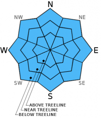
CONSIDERABLE avalanche danger exists on all aspects near and above treeline due to a combination of wind slab and storm slab formation. MODERATE avalanche danger exists below treeline with pockets of CONSIDERABLE danger on slopes steeper than 35 degrees. Natural avalanches are possible and human triggered slides are likely. Carefull snowpack and terrain evaluation, cautious route finding and conservative decision making will be essential.


Avalanche Problem 1: Wind Slab
-
Character ?

-
Aspect/Elevation ?

-
Likelihood ?CertainVery LikelyLikelyPossible
 Unlikely
 -
Size ?HistoricVery LargeLargeSmall

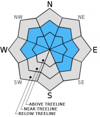
Wind slab avalanche danger has increased with the moderate to strong southerly to westerly winds associated with yesterday's storm system. Small to large wind slabs have formed on leeward W-NW-N-NE-E-SE facing slopes. Strong winds have scoured ridge tops and have loaded both typical and non-typical areas such as mid-slope starting zones, depressions around rock outcroppings, etc. All terrain, near and above treeline, should be considered dangerous today. Wind slab avalanche danger will increase further with tonight's storm. It is immediately after the storm with favorable weather when skiers and riders tend to venture above treeline where wind slabs could remain quite sensitive. With any travel above treeline today one should avoid terrain traps, slopes 35 degrees and steeper, and known avalanche paths and runout zones. Open, unsupported snow slopes above cliffs, wind loaded steep chutes and couloirs, and other complex or extreme terrain will represent the best places to find sensitive wind slabs today.
Avalanche Problem 2: Storm Slab
-
Character ?

-
Aspect/Elevation ?
-
Likelihood ?CertainVery LikelyLikelyPossible
Unlikely
-
Size ?HistoricVery LargeLargeSmall
Storm slabs will be at there most sensitive in areas near and above treeline and on slopes 35 degrees and steeper below treeline. Storm slabs that have developed with yesterday's storm totals of 9-11 new inches of snow sit may not have bonded well, quite yet, with snow underneath. A human triggered storm/soft slab avalanche was reported on a northerly aspect below treeline on an open, steep rollover. Today, the added weight from additional snow or a skier/rider could tip the stress vs. strength balance causing an avalanche. Evaluate snow and terrain carefully using cautious route finding and conservative decision making today.
Avalanche Problem 3: Cornice
-
Character ?

-
Aspect/Elevation ?
-
Likelihood ?CertainVery LikelyLikelyPossible
Unlikely
-
Size ?HistoricVery LargeLargeSmall
Cornices of varying size have formed along ridge tops hanging over leeward, wind loaded aspects. They have been building steadily over the past couple of days and may be sensitive. Give them plenty of space and use them to help identify wind loaded areas and aspects. They can break off the terrain suddenly and pull back onto the ridge top and catch people by surprise, even on flat ground above the slope. Even small cornices have enough mass to be destructive and deadly. Cornice failure could trigger wind slab or storm slab avalanches, as well.
Forecast Discussion
Gusty winds continued through the day yesterday with plenty of new light and fluffy snow to transport about. A healthy dose of the white stuff began to fall between 9 and 10 am with up to 6+ total inches falling in Mt. Shasta City and 9-11 inches in the surrounding area. At the Old Ski Bowl weather station, 0.97 inches of water was recorded and 0.7 inches in Mt. Shasta City. The outlook for our immediate future is good if you love stormy weather. To quote the NOAA forecast discussion, "This weekend through next week the storms will keep on rolling into the forecast area." Clear skies will greet folks as they start their day today, but clouds are set to increase as the next storm system approaches. This next system will start with a warm front then cool as it passes. Snow levels will rise as the front approaches, then lower as it moves over the area. Lucky for us, snow levels will not rise to quite the level as originally forecast (6,000-7,000 ft.), but will hover in the 4,000-4,500 ft. range. Precipitation models forecast water amounts totaling 0.64 inches for this storm which will translate into 5-7 inches of new snow for winter recreation enthusiasts! Strong W-SW winds will accompany this storm system prompting the issuance of a "high wind watch". A stronger storm system is on deck for Sunday into Monday bringing over double the amount of water/precipitation as tonights storm (up to 1.98 inches of water). We'll be keeping an eye on snow levels in addition to the precipitation and wind with this weekend's storms. While the snow levels are forecast to be higher, they will lower and may be lower than expected for our area. Stay tuned...
THIS SEASON PRECIPITATION: Since October 1st (the wet season), we have received 14.29 inches of water, normal is 18.58 inches, putting us at 76% of normal. For the month of January and year of 2016 we've received 4.80 inches of water, normal is 3.37 inches, putting us at 142% of normal
Recent Observations
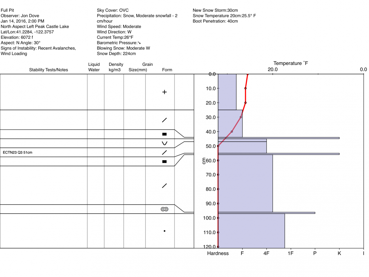
A ski tour made yesterday up Left Peak at Castle Lake revealed a couple of things concerning the snowpack. Wind slabs and soft slabs were abundant with all the new snow that fell with yesterday's storm. Additionally, the lighter snow under heavier snow resulting from warming earlier in the week seems to have settled under the weight of all the new snow brought by two consecutive storms (widespread "whumphing" was reported from both Grey Butte and Green Butte Rdg on Wed.). That being said, the significant amount of new snow has presented it's own concerns, namely wind slab and storm slab instabilities. There was a report of a human triggered soft storm slab that had a crown depth of 6-8 inches, was approximately 15 ft. in width, and traveled roughly 20-25 ft down slope. The person who triggered the slide took a short ride on top of the moving snow, resulting in some slightly rattled nerves but little else. The slide took place in an opening in the trees on a steep rollover along the convexity at its top. A full pit profile was performed in a snow study pit dug on a N aspect on Left Peak (available below), and an extended column stability test was done as well. The test resulted in a score of ECTN 23 Q3 approx. 51 cm deep just below the rain crust that formed Tuesday. A closer look at the crystals of the layer that failed showed rounding plates and stellars that are remnants of surface hoar that formed last weekend.
Storm totals of 9-11 inches from yesterdays storm have elevated the avalanche danger for the aforementioned wind and storm slabs for all elevations and aspects. The snowpack seems to have transitioned back to a "right side up" snow layer structure which is an improvement. The ECT performed showed that moderate effort was required to initiate a failure within the top two feet of the snowpack with no propagation and poor shear quality. However, wind slabs that have formed will be sensitive to trigger, cornice formations are numerous, and storm slabs will be widespread. Travel well spaced, and one at a time through known avalanche paths and runout zones. Have good, open communication with your travel partners, choose your route conservatively, and pay close attention to snowpack and terrain. Avoid wind loaded and open slopes of 35 degrees and steeper near and above treeline. Do not let your guard down below treeline. Natural avalanches are possible, and human triggered slides are likely today. With the sunshine and warming temperatures, their impact on the snowpack may be a repeat of earlier this week. The upper several inches of new snow may become heavier and more dense than the snow just below causing the "upside down" effect. This could add to snow instabilities with the addition of new snow on top with tonights storm. Wind slabs will be present on open and exposed leeward W-NW-N-NE-E-SE aspects. Local orographics and winds may load other aspects as well, and in non-typical starting zones below ridge tops and in depressions.
A video of the wind event atop Grey Butte 1-13-2016, can be viewed at http://www.youtube.com/watch?v=wWB2C35LxTo.
Full Pit Profile on a N aspect of Left Peak, Castle Lake from 1-14-2016 by Jon Dove:
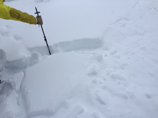
Soft slab observed from the east side of forecast area on a North aspect near treeline 1-14-2016 photo: Nick Meyers
______________________________________________________________________________________________________________________________________________________
LOCAL AREA ROAD, NORDIC and SNOWMOBILE PARK STATUS:
The Sand Flat cross country ski trails are in great shape and ready for your cross country skis or snow shoes. These are backcountry trails marked with blue diamonds on trees. Trails are not groomed. Snow shoers, please blaze a parallel trail to cross country skiers staying out of the skin track. These trails can be accessed via the Everett Memorial Highway. Thank you, and enjoy!
The Mt Shasta Nordic Center is open! These beautiful, groomed trails can be accessed via the Ski Park Highway. http://www.mtshastanordic.org
The Pilgrim Creek & Deer Mountain Snowmobile Parks are open! Trails are being groomed currently. Head to our "Education" tab on our website and find the snowmobile section for trail information, grooming status and other sledder resources!
The Castle Lake road is plowed to the Vista Point. The Everett Memorial Highway is plowed to Bunny Flat.
The Five Red Flags of Avalanche Danger any time of year include: 1) Recent/current avalanche activity 2) Whumphing sounds or shooting cracks 3) Recent/current heavy snowfall 4) Strong winds transporting snow 5) Rapid warming or rain on snow.
Weather and Current Conditions
Weather Summary
Good Morning! In Mt Shasta City at 0500, we have a current temperature of 30 F, three degrees warmer than yesterday at this time, with clear skies and calm wind.
On Mt Shasta (South Side) in the last 24 hours...
Old Ski Bowl - 7,600 feet, the current temperature is 19 degrees F. Snow on the ground totals 93 inches with 11 inches new snow and no settlement. Temperatures have ranged from 16 F to 21 F.
Grey Butte - 8,000 feet, the current temperature is 16 degrees F. Temperatures have ranged from 14 F to 20 F. Winds have been averaging 15-20 mph and variable in nature with a max gust to 56 mph, NW.
Mt Eddy Range (West side of Interstate-5)...
Castle Lake - 5,600 feet, the current temperature is 22 degrees F. Temperatures have ranged from 22 F to 26 F. Snow on the ground measures 69 inches with 7 inches of new snow and no settlement.
Mt Eddy - 6,500 feet, the current temperature is 20 degrees F. Temperatures have ranged from 20 F to 25 F. Snow on the ground measures 77 inches with 9 inches of new snow and no settlement. The anemometer appears to have stopped working, so wind speed and direction is not available. We will monitor.
Always check the weather before you attempt to climb Mt Shasta. Further, monitor the weather as you climb. Becoming caught on the mountain in any type of weather can compromise life and limb. Be prepared.
| 0600 temperature: | 19 |
| Max. temperature in the last 24 hours: | 26 |
| Average wind direction during the last 24 hours: | Variable |
| Average wind speed during the last 24 hours: | 15-20 mi/hr |
| Maximum wind gust in the last 24 hours: | 56 mi/hr |
| New snowfall in the last 24 hours: | 9 inches |
| Total snow depth: | 82 inches |
Two Day Mountain Weather Forecast
Produced in partnership with the Medford NWS
| For 7000 ft to 9000 ft | |||
|---|---|---|---|
|
Friday (4 a.m. to 10 p.m.) |
Friday Night (10 p.m. to 4 a.m.) |
Saturday (4 a.m. to 10 p.m.) |
|
| Weather | Clear then increasing clouds. A chance of snow showers before 10 am, then snow likely after 4 pm. | Cloudy, snow. Breezy | Mostly cloudy. Snow before 10 am, then snow showers, mainly between 10 am and 4 pm. WIndy |
| Temperature (°F) | 30 | 28 | 31 |
| Wind (mi/hr) | North/northeast becoming south/southeast in the afternoon 5-10 mph | South 15-20 mph with gusts to 30 mph | South 20-25 mph with gusts to 35 mph. |
| Precipitation SWE / Snowfall (in) | / 0-.5 | / 2-4 | / 3-7 |
| For 9000 ft to 11000 ft | |||
| Friday | Friday Night | Saturday | |
| Weather | Clear then increasing clouds. A chance of snow showers before 10 am, then snow likely after 4 pm. Windy with wind chill values as low as -6 | Cloudy, snow. Windy | Mostly cloudy. Snow before 10 am, then snow showers, mainly between 10 am and 4 pm. Windy with wind chill values as low as -1. |
| Temperature (°F) | 26 | 25 | 24 |
| Wind (mi/hr) | North/northwest becoming west in the afternoon 25-30 with gusts to up to 45 mph | West/southwest 0-.5 | West/southwest increasing to 50-55 mph with higher gusts. |
| Precipitation SWE / Snowfall (in) | / 0-.5 | / 3-5 | / 3-7 |

