

You are here
Avalanche Advisory for 2016-01-16 07:08:57
- EXPIRED ON January 17, 2016 @ 7:08 amPublished on January 16, 2016 @ 7:08 am
- Issued by Nick Meyers - Shasta-Trinity National Forest
Bottom Line
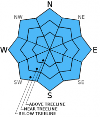
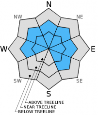
CONSIDERABLE avalanche danger exists on all aspects near and above treeline for wind slab and storm slab avalanches. MODERATE avalanche danger exists below treeline. Slopes steeper than 35 degrees, convex roll overs, rocky outcrops, extreme terrain and steep couloirs should be most suspect.


Avalanche Problem 1: Wind Slab
-
Character ?

-
Aspect/Elevation ?

-
Likelihood ?CertainVery LikelyLikelyPossible
 Unlikely
 -
Size ?HistoricVery LargeLargeSmall

Wind slabs will build in size over the next 48 hours with a doozy of a storm on tap bringing feet of snow and S-SW-W winds. Small to large wind slabs are certain on leeward W-NW-N-NE-E-SE facing slopes. Slab stability is uncertain and hard to predict so tread lightly. Slabs sit on top of widespread 1-2 cm thick rain crust. Strong winds have scoured ridge tops and have loaded both typical and non-typical areas such as mid-slope starting zones, depressions around rock outcropping, steep couloirs, cross loading of slopes. It is immediately after the storm with favorable weather when skiers and riders tend to venture above treeline where wind slabs could remain sensitive. Open, unsupported snow slopes above cliffs, wind loaded steep chutes and couloirs, and other complex or extreme terrain will represent the best places to find potentially sensitive wind slabs today.
Avalanche Problem 2: Storm Slab
-
Character ?

-
Aspect/Elevation ?
-
Likelihood ?CertainVery LikelyLikelyPossible
Unlikely
-
Size ?HistoricVery LargeLargeSmall
Warming temperatures have helped settle the 9-11 inches of new snow received recently. Soft slabs may linger in the forecast area however. Slopes steeper than 37 degrees should be most suspect.
A human triggered soft slab avalanche was reported on a northerly aspect below treeline on an open, steep rollover two days ago. Yesterday, a naturally triggered soft slab was reported from the Caslte Lake area.
Avalanche Problem 3: Cornice
-
Character ?

-
Aspect/Elevation ?
-
Likelihood ?CertainVery LikelyLikelyPossible
Unlikely
-
Size ?HistoricVery LargeLargeSmall
Cornices of varying size have formed along ridge tops hanging over leeward, wind loaded aspects. They have been building steadily across the forecast area and will continue to do so. Give them plenty of space and use them to help identify wind loaded areas and aspects. They can break off the terrain suddenly and pull back onto the ridge top and catch people by surprise, even on flat ground above the slope. Even small cornices have enough mass to be destructive and deadly. Cornice failure can trigger wind slab or storm slab avalanches.
Forecast Discussion
We sit on the brink of storm number three of three today, though the parade of storms will continue through next week. Scattered snow showers today with perhaps a little bit of sky showing at times will serve us before the whopper arrives tonight. The one everyone has been talking about is set to arrive overnight and bring a deluge of water and windy conditions to the forecast area. We're staring down the barrel at just shy of 2 inches of water to blast Northern California over the next 48 hours. High snow levels is the bummer with this one... 4,600 feet today, 5,800 feet tonight and 6,700 feet tomorrow. This has flooding concerns being mentioned as copious amounts of water fall on top of our current snowpack. Don't worry, I surely have not forgot about the wind... indeed the wind will blow, south to southwest in nature 20-30 mph below and near treeline in exposed areas. Above treeline, hold on to your hats! Expect 40-50 mph with gusts much higher, south/southwest. Sunday might be a good day to fire up Netflix, a fire and some popcorn.
THIS SEASON PRECIPITATION: Since October 1st (the wet season), we have received 14.34 inches of water, normal is 18.81 inches, putting us at 76% of normal. For the month of January and year of 2016 we've received 4.85 inches of water, normal is 3.60 inches, putting us at 134% of normal
Recent Observations
Yesterday, 1.16.16, a medium size natural soft slab avalanche occured on a northerly aspect near Castle/Heart Lake area.
A small skier triggered soft slab was triggered east of Castle Lake on a West/Northwest aspect on 1.15.16
Wind slabs and soft slabs have been the main avalanche problems with all the new snow that fell on the 14th. A few natural and skier tiggered slides have occured as well as numerous reports of whumphing in the snowpack over the past few days. That said, warming temperatures have helped settle the new snow. Soft slab instabilities will likely be far and few between today. Wind slabs and cornices are out there and while we have some uncertainty as to their sensitivity, we do know wind slabs continue to build in depth and width. Above treeline areas should be most suspect and cautious route finding important to avoid wind slabs.
At the forefront regarding avalanche danger is the impressive amount of water forecasted to fall over the area during the next 48 hours. Further, rising temperatures will give way to rising snow levels and rain on snow below treeline. Wet-loose related snow instabilities should be on your mind. Roller balls are relatively harmless, however we've got 1-2 feet of new snow sitting on top of our 1-2 cm thick rain crust... Add heavy, wet snow and/or rain on snow and we could see wet-loose/wet slab type avalanches. Rain only adds weight to the snowpack, not strength. Any wet-loose/wet slab instability due to rain on snow will be immediate. Areas up to about 7,000 feet could get rain on snow. Elevations above 7,000 will see snow, albeit heavy snow. Sunday just might be a good day for a cozy fire and a movie!
Travel well spaced and one at a time through known avalanche paths and runout zones. Have good, open communication with your travel partners, choose your route conservatively and pay close attention to the snowpack and terrain. Avoid wind loaded, open slopes 35 degrees and steeper near and above treeline.
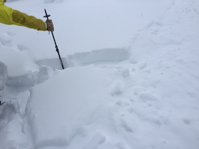
Soft slab observed from the east side of forecast area on a North aspect near treeline 1-14-2016 photo: Nick Meyers
______________________________________________________________________________________________________________________________________________________
LOCAL AREA ROAD, NORDIC and SNOWMOBILE PARK STATUS:
The Sand Flat cross country ski trails are in great shape and ready for your cross country skis or snow shoes. These are backcountry trails marked with blue diamonds on trees. Trails are not groomed. Snow shoers, please blaze a parallel trail to cross country skiers staying out of the skin track. These trails can be accessed via the Everett Memorial Highway. Thank you, and enjoy!
The Mt Shasta Nordic Center is open! These beautiful, groomed trails can be accessed via the Ski Park Highway. http://www.mtshastanordic.org
The Pilgrim Creek & Deer Mountain Snowmobile Parks are open! Trails are being groomed currently. Head to our "Education" tab on our website and find the snowmobile section for trail information, grooming status and other sledder resources!
The Castle Lake road is plowed to the Vista Point. The Everett Memorial Highway is plowed to Bunny Flat.
The Five Red Flags of Avalanche Danger any time of year include: 1) Recent/current avalanche activity 2) Whumphing sounds or shooting cracks 3) Recent/current heavy snowfall 4) Strong winds transporting snow 5) Rapid warming or rain on snow.
Weather and Current Conditions
Weather Summary
Good Morning! In Mt Shasta City at 0500, we have a current temperature of 35 F, five degrees warmer than yesterday at this time, with light precipitation.
On Mt Shasta (South Side) in the last 24 hours...
Old Ski Bowl - 7,600 feet, the current temperature is 23 degrees F. Snow on the ground totals 90 inches with 2-4 inches new snow and 4 inches settlement. Temperatures have ranged from 15 F to 28 F.
Grey Butte - 8,000 feet, the current temperature is 21 degrees F. Temperatures have ranged from 17 F to 23 F. Winds have been averaging 10-15 mph, westerly in nature with a max gust to 28 mph, westerly also.
Mt Eddy Range (West side of Interstate-5)...
Castle Lake - 5,600 feet, the current temperature is 27 degrees F. Temperatures have ranged from 20 F to 33 F. Snow on the ground measures 70 inches with 2-4 inches of new snow and 2-3 inches settlement.
Mt Eddy - 6,500 feet, the current temperature is 27 degrees F. Temperatures have ranged from 15 F to 30 F. Snow on the ground measures 77 inches with 2-4 inches of new snow and 2-3 inches settlement. Wind speed and direction is not available at this time.
Always check the weather before you attempt to climb Mt Shasta. Further, monitor the weather as you climb. Becoming caught on the mountain in any type of weather can compromise life and limb. Be prepared.
| 0600 temperature: | 25 |
| Max. temperature in the last 24 hours: | 32 |
| Average wind direction during the last 24 hours: | Westerly |
| Average wind speed during the last 24 hours: | 10-15 mi/hr |
| Maximum wind gust in the last 24 hours: | 28 mi/hr |
| New snowfall in the last 24 hours: | 2-4 inches |
| Total snow depth: | 81 inches |
Two Day Mountain Weather Forecast
Produced in partnership with the Medford NWS
| For 7000 ft to 9000 ft | |||
|---|---|---|---|
|
Saturday (4 a.m. to 10 p.m.) |
Saturday Night (10 p.m. to 4 a.m.) |
Sunday (4 a.m. to 10 p.m.) |
|
| Weather | Snow before 10am then snow showers, mainly between 10am and 4pm, windy | Chance of snow showers before 10pm, then snow after 10pm, breezy | Snow before 10am, then rain and snow, heavy at times |
| Temperature (°F) | 32 | 30 | 35 |
| Wind (mi/hr) | South` 20-30 mph | South 20-30 mph | South 20-30 mph |
| Precipitation SWE / Snowfall (in) | / 2-4 | / 2-4 | / 4-7 |
| For 9000 ft to 11000 ft | |||
| Saturday | Saturday Night | Sunday | |
| Weather | Snow and windy | Snow and windy | Snow, heavy at times, windy |
| Temperature (°F) | 23 | 23 | 24 |
| Wind (mi/hr) | Southwest 40-50 mph | West 3-5 | Southwest 40-50 mph |
| Precipitation SWE / Snowfall (in) | / 3-5 | / 4-8 | / 17-23 |

