

You are here
Avalanche Advisory for 2016-01-17 07:03:37
- EXPIRED ON January 18, 2016 @ 7:03 amPublished on January 17, 2016 @ 7:03 am
- Issued by Jon Dove - Shasta-Trinity National Forest
Bottom Line
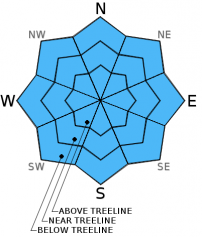
CONSIDERABLE avalanche danger exists on all aspects near and above treeline for wind slab and storm slab avalanches. MODERATE avalanche danger exists below treeline. Slopes steeper than 35 degrees, convex roll overs, rocky outcrops, extreme terrain and steep couloirs should be most suspect. A variety of avalanche conditions exist and human triggered avalanches have been common over the past couple of days. Identify pertinent avalanche hazards and evaluate snow and terrain carefully. Cautious route finding and conservative decision making essential.


Avalanche Problem 1: Wind Slab
-
Character ?

-
Aspect/Elevation ?

-
Likelihood ?CertainVery LikelyLikelyPossible
 Unlikely
 -
Size ?HistoricVery LargeLargeSmall

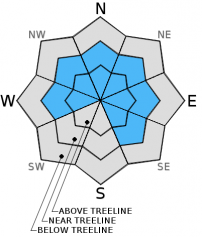
Wind slabs will build in size over the next 48 hours with today's robust storm, and another system on deck for Monday night into Tuesday. Today's storm will bring 2+ feet of snow and strong S-SW winds, especially near and above treeline elevations. Small to large wind slabs are certain on leeward W-NW-N-NE-E facing slopes. Slab stability remains uncertain and hard to predict. Slabs sit on top of widespread 1-2 cm thick rain crust. Strong winds have scoured ridge tops and have loaded both typical and non-typical areas such as mid-slope starting zones, depressions around rock outcropping, steep couloirs, cross loading of slopes. It is immediately after the storm with favorable weather when skiers and riders tend to venture above treeline where wind slabs could remain sensitive. Open, unsupported snow slopes above cliffs, wind loaded steep chutes and couloirs, and other complex or extreme terrain will represent the best places to find potentially sensitive wind slabs today.
Avalanche Problem 2: Storm Slab
-
Character ?

-
Aspect/Elevation ?
-
Likelihood ?CertainVery LikelyLikelyPossible
Unlikely
-
Size ?HistoricVery LargeLargeSmall
Warming temperatures have helped settle the 9-11 inches of new snow received recently. Soft slabs sensitivities will diminish below treeline due to rain on snow. Snow levels are expected to reach 7,000 ft. Slopes steeper than 37 degrees above 7,000 ft. will be the most suspect for soft slab instabilities today.
A human triggered soft slab avalanche was reported on a northerly aspect of Left Peak below treeline on an open, steep rollover yesterday at Castle Lake. Two days ago, a naturally triggered soft slab was also reported on a NE aspect from the Castle Lake area. A human triggered soft slab avalanche along the convexity of a steep roll over on the north aspect of Left Peak was reported on 1/14/2016 as well.
Avalanche Problem 3: Cornice
-
Character ?

-
Aspect/Elevation ?
-
Likelihood ?CertainVery LikelyLikelyPossible
Unlikely
-
Size ?HistoricVery LargeLargeSmall
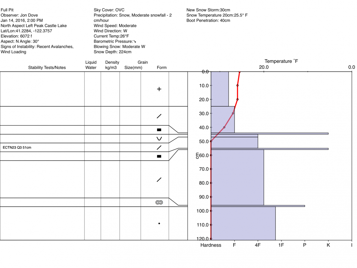
Cornices of varying size have formed along ridge tops hanging over leeward, wind loaded aspects. They have been building steadily across the forecast area and will continue to do so. Give them plenty of space and use them to help identify wind loaded areas and aspects. They can break off the terrain suddenly and pull back onto the ridge top and catch people by surprise, even on flat ground above the slope. Even small cornices have enough mass to be destructive and deadly. Cornice failure can trigger wind slab or storm slab avalanches as was the case yesterday near the top of Left Peak at Castle Lake. A medium sized cornice broke from the ridge top and triggered a soft slab avalanche above the rain crust from earlier in the week.
Forecast Discussion
Light rain has begun to fall in Mt. Shasta City this morning as the "main event" for the weekend starts to take place. What looks to be a whopper of a storm has precipitation models suggesting up to 2.29 inches of water over our area for the next 24 hours. Unfortunately, the snow levels associated with this storm have maintained their relatively high stance rising to close to 7,000 ft. There is, however, a possibility that during peak rates of precipitation there could be some cooling of the surrounding air mass that will push the snow level slightly lower. Significant snow accumulations will be confined to elevations above 7,000 ft., with some light accumulation possible down to 5,500 ft. Snow fall totals could reach up to 2+ feet at higher elevations. The bright side of these higher snow levels is that our thick snowpack is robust enough above 5,500 ft. to absorb any rain. Winds will increase through the day as the storm system tracks through, and then begin to ease slightly after midnight. Winds at mid-mountain (10,000 ft.) and higher will boarder on hurricane levels, around 75 mph, out of the S-SW. Rain, snow, and showers will continue through early Monday with the next area of low pressure arriving late Monday night into Tuesday. This storm will bring another round of substantial snow and rain, but not as strong as today's storm. Precipitation amounts forecast for this system call for the majority of rain and snow to arrive on Tuesday with as much as 0.81 inches of water. Snow levels will lower to near 5,000-5,500 ft.
THIS SEASON PRECIPITATION: Since October 1st (the wet season), we have received 14.67 inches of water, normal is 19.04 inches, putting us at 77% of normal. For the month of January and year of 2016 we've received 5.18 inches of water, normal is 3.83 inches, putting us at 135% of normal
Recent Observations
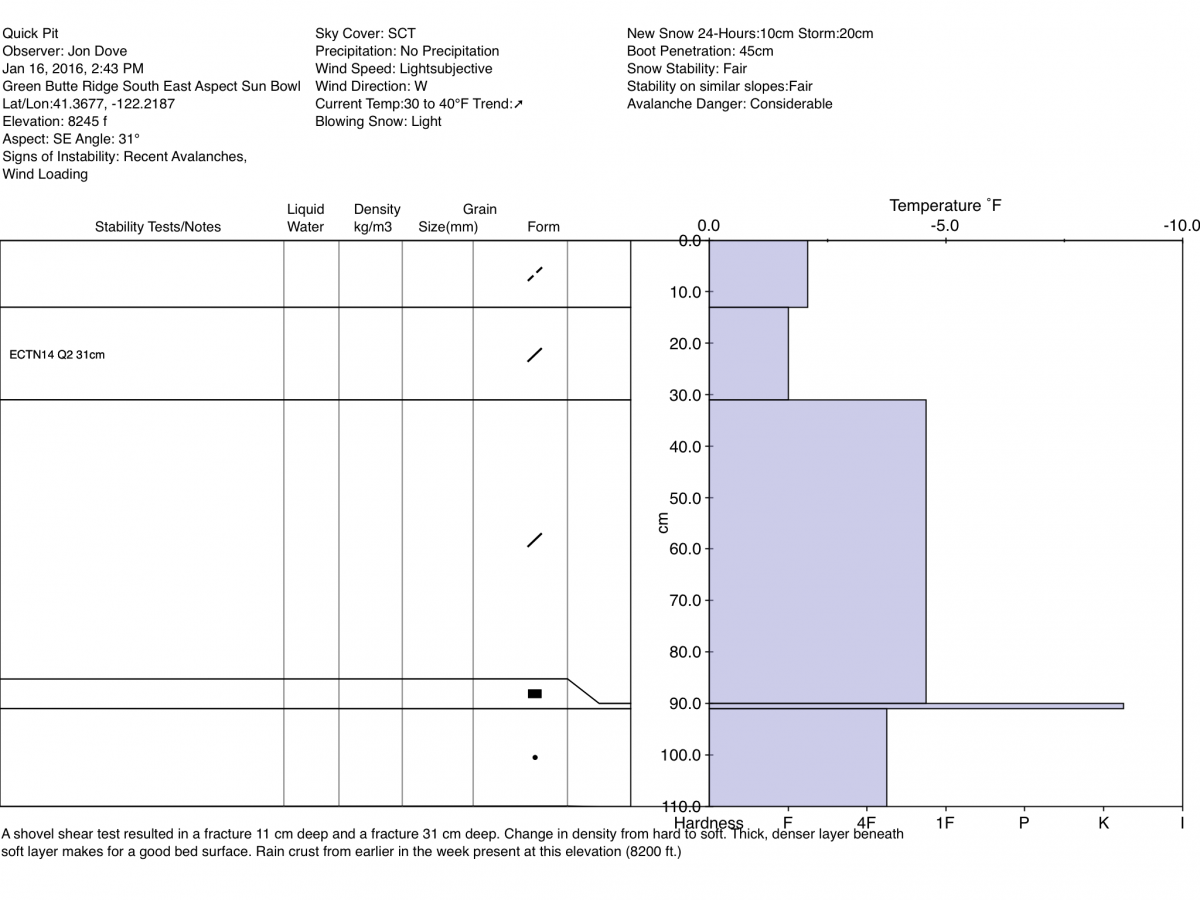
We have an abundance of information from the field yesterday coming from multiple locations in our forecast area. Snow conditions and observations run the gamut ranging from "right side up" snow layer structure to "upside down", wind loaded slopes, cornices, soft storm slabs, natural and human triggered avlanches. First, allow me to tell you what I found on Mt. Shasta just above treeline (8,200 ft), along the edge of Green Butte ridge as it drops into lower Sun Bowl, southeast aspect.
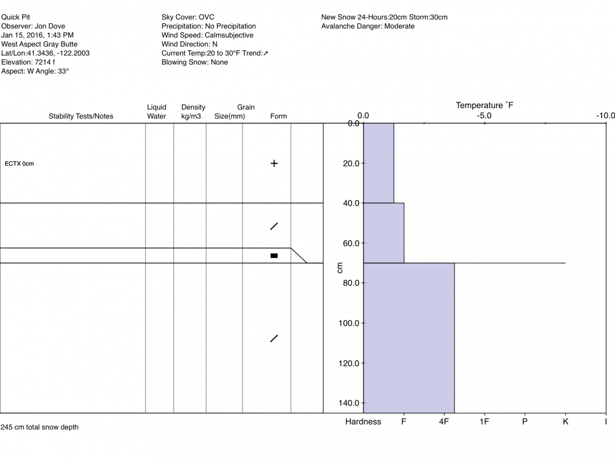
A snow study pit dug at that location revealed obvious wind loading with some weakness in the bonding of higher density wind deposited snow sitting on top of slightly less dense wind deposited snow. All this sat on top of the widespread rain crust. I was surprised to find evidence of the rain crust at 8,200 ft., but it was there. An extended column test resulted in a score of ECTN 14 Q2 with a fracture depth of 31 cm. A shovel shear test was performed and easy to moderate failures occured at 11 cm deep, and again at 31 cm deep, as previously indicated. Keep in mind that the shovel shear test only indicates the location of weaker bonding. The sensitivity of wind slabs, in the various locations they exist, remains uncertain. The ferocity of this storm will keep folks from wandering into areas above treeline where wind slabs mostly exist, however wind deposited snow and cornices exist near treeline, as well. Avalanche danger associated with wind slabs will increase with today's storm and the accompanying high winds.
Second, the Castle Lake area remained active yesterday with two separate avalanches occurring; one naturally triggered and one skier triggered, both on Left Peak. I will present the details bullet point style:
- 1/16/2016-stormy and windy
- Skier triggered soft slab along convexity of steep rollover around rocky outcropping
- 18-20 inch crown at deepest point, and approximately 50 ft. in width
- Slide stepped down to a deeper weak layer in areas
- 2 weak layers noted above rain crust layer. One approximately 20 cm deep and one about 30 cm deep
- Perhaps a density change in snowpack, or small faceting taking place due to steep temperature gradient ABOVE rain crust
- One naturally triggered avalanche near ridge top on Left Peak caused by cornice collapse and subsequent trigger of soft storm slab above rain crust on slope beneath
There were also reports given from the northerly aspect of Right Peak where shooting cracks, and stiff slabs of heavier snow over lighter density snow exist.
At the forefront regarding avalanche danger is the impressive amount of water forecasted to fall over the area during the next 48 hours. Further, rising temperatures will give way to rising snow levels and rain on snow below treeline. Wet-loose related snow instabilities should be on your mind. Roller balls are relatively harmless, however we've got 1-2 feet of new snow sitting on top of our 1-2 cm thick rain crust... Add heavy, wet snow and/or rain on snow and we could see wet-loose/wet slab type avalanches. Rain only adds weight to the snowpack, not strength. Any wet-loose/wet slab instability due to rain on snow will be immediate. Areas up to about 7,000 feet could get rain on snow. Elevations above 7,000 will see snow, albeit heavy snow.
Travel well spaced and one at a time through known avalanche paths and runout zones. Have good, open communication with your travel partners, choose your route conservatively and pay close attention to the snowpack and terrain. Avoid wind loaded, open slopes 35 degrees and steeper near and above treeline.
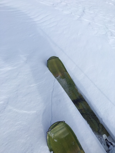
Quick Pit from 1/16/2016 @ 8,200 ft on a SE aspect, lower edge of Sun Bowl by Jon Dove:
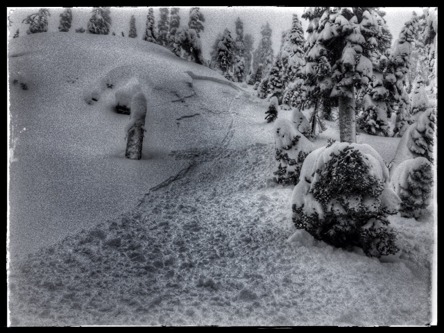
Cracking of wind slab under skis along wind loaded edge of Sun Bowl, 1/16/2016-photo: Jon Dove
Skier triggered soft slab avalanche along steep roll over, N aspect Left Peak, Castle Lake on 1/16/2016:
Previous pit profiles 1/14-15/2016. Note the temperature gradient around rain crust in 1/14 profile from Left Peak:
______________________________________________________________________________________________________________________________________________________
LOCAL AREA ROAD, NORDIC and SNOWMOBILE PARK STATUS:
The Sand Flat cross country ski trails are in great shape and ready for your cross country skis or snow shoes. These are backcountry trails marked with blue diamonds on trees. Trails are not groomed. Snow shoers, please blaze a parallel trail to cross country skiers staying out of the skin track. These trails can be accessed via the Everett Memorial Highway. Thank you, and enjoy!
The Mt Shasta Nordic Center is open! These beautiful, groomed trails can be accessed via the Ski Park Highway. http://www.mtshastanordic.org
The Pilgrim Creek & Deer Mountain Snowmobile Parks are open! Trails are being groomed currently. Head to our "Education" tab on our website and find the snowmobile section for trail information, grooming status and other sledder resources!
The Castle Lake road is plowed to the Vista Point. The Everett Memorial Highway is plowed to Bunny Flat.
The Five Red Flags of Avalanche Danger any time of year include: 1) Recent/current avalanche activity 2) Whumphing sounds or shooting cracks 3) Recent/current heavy snowfall 4) Strong winds transporting snow 5) Rapid warming or rain on snow.
Weather and Current Conditions
Weather Summary
Good Morning! In Mt Shasta City at 0500, we have a current temperature of 41 F, six degrees warmer than yesterday at this time, with light rain.
On Mt Shasta (South Side) in the last 24 hours...
Old Ski Bowl - 7,600 feet, the current temperature is 29 degrees F. Snow on the ground totals 91 inches with 3 inches new snow and 2 inches settlement. Temperatures have ranged from 23 F to 29 F.
Grey Butte - 8,000 feet, the current temperature is 28 degrees F. Temperatures have ranged from 21 F to 29 F. Winds have been averaging 15-20 mph, westerly in nature with a max gust to 49 mph, westerly also.
Mt Eddy Range (West side of Interstate-5)...
Castle Lake - 5,600 feet, the current temperature is 32 degrees F. Temperatures have ranged from 26 F to 34 F. Snow on the ground measures 70 inches with 2 inches of new snow and 2 inches settlement.
Mt Eddy - 6,500 feet, the current temperature is 32 degrees F. Temperatures have ranged from 26 F to 32 F. Snow on the ground measures 78 inches with 3 inches of new snow and 1 inch of settlement. Winds have averaged 2 mph, southerly in direction with a max gust of 18 mph, SSE.
Always check the weather before you attempt to climb Mt Shasta. Further, monitor the weather as you climb. Becoming caught on the mountain in any type of weather can compromise life and limb. Be prepared.
| 0600 temperature: | 32 |
| Max. temperature in the last 24 hours: | 32 |
| Average wind direction during the last 24 hours: | Westerly |
| Average wind speed during the last 24 hours: | 15-20 mi/hr |
| Maximum wind gust in the last 24 hours: | 49 mi/hr |
| New snowfall in the last 24 hours: | 0-2 inches |
| Total snow depth: | 80 inches |
Two Day Mountain Weather Forecast
Produced in partnership with the Medford NWS
| For 7000 ft to 9000 ft | |||
|---|---|---|---|
|
Sunday (4 a.m. to 10 p.m.) |
Sunday Night (10 p.m. to 4 a.m.) |
Monday (4 a.m. to 10 p.m.) |
|
| Weather | Snow before 10 am, then rain between 10 am and 4 pm, then rain and snow after 4 pm. The rain and snow could be heavy at times. Windy | Rain and snow showers, becoming all snow after 10 pm. The rain and snow could be heavy at times. Breezy | Mostly cloudy. Snow showers likely, mainly after 4 pm |
| Temperature (°F) | 35 | 26 | 32 |
| Wind (mi/hr) | South 20-30 mph | Southwest 10-20 mph | South 10-15 mph |
| Precipitation SWE / Snowfall (in) | / 3-7 | / 3-7 | / 1-2 |
| For 9000 ft to 11000 ft | |||
| Sunday | Sunday Night | Monday | |
| Weather | Snow. Snow could be heavy at times. Windy with wind chill values as low as -1 | Snow showers. The snow could be heavy at times. Windy with wind chill values as low as -5 | Mostly cloudy. Snow showers likely, mainly before 4 pm. Windy with wind chill values as low as -5 |
| Temperature (°F) | 26 | 18 | 20 |
| Wind (mi/hr) | South/southwest 70-75 mph with gusts to 85+ mph | Southwest 16-22 | Southwest 25-30 mph with gusts to 55 mph |
| Precipitation SWE / Snowfall (in) | / 16-22 | / 5-9 | / 1-2 |

