

You are here
Avalanche Advisory for 2016-01-18 07:07:19
- EXPIRED ON January 19, 2016 @ 7:07 amPublished on January 18, 2016 @ 7:07 am
- Issued by Nick Meyers - Shasta-Trinity National Forest
Bottom Line
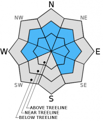
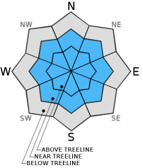
The avalanche danger will rise as one gains elevation.
Areas below treeline (<7,000 feet) will host LOW avalanche danger. Near treeline, expect MODERATE avalanche danger and above treeline CONSIDERABLE danger.
One to two feet of new snow has fallen over the past 24 hours with moderate wind blowing out of the S-SW-W. Wind & storm slabs and cornice features continue to grow in the forecast area.


Avalanche Problem 1: Wind Slab
-
Character ?

-
Aspect/Elevation ?
-
Likelihood ?CertainVery LikelyLikelyPossible
 Unlikely
 -
Size ?HistoricVery LargeLargeSmall

Wind slab sensitivity is uncertain and difficult to predict. We can gurantee though that small to large wind slabs exist near and above treeline and could remain sensitive to trigger. Recent heavy snowfall with south to west wind has loaded NW-N-NE-E slopes and cross-loaded other slopes such as W-SW-S. Slabs sit on top of widespread 1-2 cm thick rain crust. Continuing storms with cloudy skies will not give the snowpack much time to adjust and at some point, the stress vs strength scale could be tipped! Strong winds have scoured ridge tops and loaded both typical and non-typical areas. Mid-slope starting zones, rock outcroppings, steep couloirs, open and unsupported snow slopes above cliffs, convexities and other complex or extreme terrain will represent the best places to find potentially sensitive wind slabs today.
Avalanche Problem 2: Storm Slab
-
Character ?

-
Aspect/Elevation ?
-
Likelihood ?CertainVery LikelyLikelyPossible
Unlikely
-
Size ?HistoricVery LargeLargeSmall
Soft slabs have been flattened below treeline due to rain on snow. Slopes steeper than 37 degrees above 7,000 ft. will be the most suspect for soft slab instabilities today. Look for areas of dense snow above lighter density snow. Use your ski pole or dig a quick hand pit to help determine where "upside down" layered snowpack might exist. Density changes in the new snow accompanied by a strong temperature gradient in the top layers of the snowpack have been the failing weak layers in recent skier and naturally triggered slides in the forecast area. Avoid wide open bowls and treeless convexities near and above treeline, all aspects.
Avalanche Problem 3: Cornice
-
Character ?

-
Aspect/Elevation ?

-
Likelihood ?CertainVery LikelyLikelyPossible
Unlikely
-
Size ?HistoricVery LargeLargeSmall
Cornices of varying size have formed along ridge tops hanging over leeward, wind loaded aspects. They have been building steadily across the forecast area and will continue to do so. Give them plenty of space and use them to help identify wind loaded areas and aspects. They can break off the terrain suddenly and pull back onto the ridge top and catch people by surprise, even on flat ground above the slope. Even small cornices have enough mass to be destructive and deadly. Cornice failure can trigger wind slab or storm slab avalanches.
Forecast Discussion
Temperatures have dropped several degrees this morning in town and at mountain weather stations. This a welcome sigh of relief as perhaps a more wintery feel will move back into the area. We should see a short break in systems today, perhaps a brief shot of the sky at times, but otherwise scattered showers and another storm set for this evening. This one will have lower snow levels though not as much precipitation as this last blast. Nothing to shake a stick at however... another inch plus of water by Tuesday evening with snow levels today at 5,500 feet, 5,600 feet tonight and 5,200 feet tomorrow, lowering to 4,700 feet by Tuesday evening. Winds in the mountains will blow out of the south/southwest 5-10 mph below treeline today and 15-20 mph near and above treeline. Wind will increase tonight and tomorrow as the storm rolls over. Another decent dollop of snow, perhaps up to a foot, is our next main focus. Until then...an inch of new snow at best today and otherwise the calm before the next storm!
THIS SEASON PRECIPITATION: Since October 1st (the wet season), we have received 16.45 inches of water, normal is 19.26 inches, putting us at 85% of normal. For the month of January and year of 2016 we've received 6.96 inches of water, normal is 4.05 inches, putting us at 171% of normal
Recent Observations
If you like puddles, yesterday was a good day for puddle jumping. Heavy rain at times fell over the forecast area with freezing levels reaching near 7,000 feet. Localized flooding occured due to rapid snow melt and rain fall. In Mt Shasta City, 1.83 inches of water was recoreded in the last 24 hours. Above 7,000 feet, recorded at the Old Ski Bowl weather station (7,900 feet) about one foot of new snow piled up, likely more in areas as 2.21 inches of water was measured with the tipping bucket. Westerly winds blew steady 20-30 mph with gusts to 50 mph. The Castle Lake area unfortunately was in the rain zone (lake level, 5,600 feet) and saw about 8 inches of settlement in the snowpack due to rain on snow. All other areas where rain on snow occured, the snowpack likely shrank similar amounts.
Observations were very limited yesterday. All slopes in the forecast that received rain on snow, that is BELOW the freezing level.... the avalanche danger is LOW. Rain on snow only adds weight to the snowpack. Any avalanches due to rain on snow likely occurred immediately. Now a wet, thick and partially frozen snowpack will serve low elevation areas with low danger.
Current concern lies for all slopes ABOVE the freezing level, approximately 7,000 feet. Ten to twelve inches of new, heavy snow fell over the past 24 hours increasing the size of storm slabs, wind slabs and cornice features. West/Southwest winds have loaded northerly and easterly slopes primarily, but expect cross loading of some southerly and westerly slopes. Storm slabs with potentially heavier, dense snow on top of lighter snow will still exist above 7,000 feet. Wind and storm slab sensitivity is uncertain. However, based on some of the skier and naturally triggered slides over the past few days in the Castle Lake area and on Mt Shasta, I think that one should continue to tread lightly in the backcountry.
Near and above treeline areas should be most suspect for wind and storm slab avalanches today. Wide, open slopes, ridgelines with cornice features and steep convexities will be the BEST places to find instability within the snowpack. Slabs could be small to large. The Castle Lake area received almost all rain on snow, so weak layer instabilities that we saw recently (natural and skier triggered slides) will be squished. It's near and above treeline on Mt Shasta and the upper ramparts of Mt Eddy that the concern lies.
Remember, your skin track up the hill is just as important as your ski line down. Choose safe up tracks... don't just follow the skin track that is set if you're not comfortable with the route. Breaking trail is a lot easier than getting caught in an avalanche. Also, tracks on a slope does NOT mean the slope is safe.
The broken record plays on... Only one at a time on a given slope. Use safe zones and make sure they are safe! Use good communication between group members. Avoid large groups. Talk about your route plan for the day and be ready to adjust your plan as you notice unstable snow such as shooting cracks, whoomfing, recent avalanches, and/or rapid accumulation of snow.
_______________________________________________________________________________________________________________________________________________
LOCAL AREA ROAD, NORDIC and SNOWMOBILE PARK STATUS:
The Sand Flat cross country ski trails are in great shape and ready for your cross country skis or snow shoes. These are backcountry trails marked with blue diamonds on trees. Trails are not groomed. Snow shoers, please blaze a parallel trail to cross country skiers staying out of the skin track. These trails can be accessed via the Everett Memorial Highway. Thank you, and enjoy!
The Mt Shasta Nordic Center is open! These beautiful, groomed trails can be accessed via the Ski Park Highway. http://www.mtshastanordic.org
The Pilgrim Creek & Deer Mountain Snowmobile Parks are open! Trails are being groomed currently. Head to our "Education" tab on our website and find the snowmobile section for trail information, grooming status and other sledder resources!
The Castle Lake road is plowed to the Vista Point. The Everett Memorial Highway is plowed to Bunny Flat.
The Five Red Flags of Avalanche Danger any time of year include: 1) Recent/current avalanche activity 2) Whumphing sounds or shooting cracks 3) Recent/current heavy snowfall 4) Strong winds transporting snow 5) Rapid warming or rain on snow.
Weather and Current Conditions
Weather Summary
Good Morning! In Mt Shasta City at 0500, we have a current temperature of 36 F, five degrees cooler than yesterday at this time, with fog obscuring the sky this morning.
On Mt Shasta (South Side) in the last 24 hours...
Old Ski Bowl - 7,600 feet, the current temperature is 24 degrees F. Snow on the ground totals 100 inches with 10 inches new snow and 1 inch settlement. Temperatures have ranged from 21 F to 31 F.
Grey Butte - 8,000 feet, the current temperature is 24 degrees F. Temperatures have ranged from 21 F to 30 F. Winds have been averaging 20-30 mph, westerly in nature with a max gust to 49 mph, westerly also.
Mt Eddy Range (West side of Interstate-5)...
Castle Lake - 5,600 feet, the current temperature is 29 degrees F. Temperatures have ranged from 29 F to 35 F. Snow on the ground measures 64 inches with no new snow and 6 inches settlement (rain on snow).
Mt Eddy - 6,500 feet, the current temperature is 23 degrees F. Temperatures have ranged from 23 F to 33 F. Snow on the ground measures 76 inches with 2-4 inches of new snow and 1-2 inches of settlement. Winds have averaged 2 mph, southerly in direction with a max gust of 13 mph, south.
Always check the weather before you attempt to climb Mt Shasta. Further, monitor the weather as you climb. Becoming caught on the mountain in any type of weather can compromise life and limb. Be prepared.
| 0600 temperature: | 29 |
| Max. temperature in the last 24 hours: | 32 |
| Average wind direction during the last 24 hours: | Westerly |
| Average wind speed during the last 24 hours: | 10-20 mi/hr |
| Maximum wind gust in the last 24 hours: | 49 mi/hr |
| New snowfall in the last 24 hours: | 4-6 / 10 at Old Ski Bowl inches |
| Total snow depth: | 82 inches |
Two Day Mountain Weather Forecast
Produced in partnership with the Medford NWS
| For 7000 ft to 9000 ft | |||
|---|---|---|---|
|
Monday (4 a.m. to 10 p.m.) |
Monday Night (10 p.m. to 4 a.m.) |
Tuesday (4 a.m. to 10 p.m.) |
|
| Weather | Mostly cloudy, chance of snow showers 60% | Snow showers, heavy at times, breezy | Snow showers, heavy at times, windy |
| Temperature (°F) | 33 | 28 | 34 |
| Wind (mi/hr) | South 5-15 mph | South 15-20 mph | South 20-30 mph |
| Precipitation SWE / Snowfall (in) | / 0-1 | / 3-7 | / 6-10 |
| For 9000 ft to 11000 ft | |||
| Monday | Monday Night | Tuesday | |
| Weather | Scattered snow showers, snow likely after 4pm, mostly cloudy, windy | Snow showers, heavy at times, windy | Snow showers, heavy at times, windy |
| Temperature (°F) | 20 | 18 | 21 |
| Wind (mi/hr) | South/southwest 20-30 mph | West/Southwest 0-1 | West 30-40 with gusts to 50 mph |
| Precipitation SWE / Snowfall (in) | / 0-1 | / 3-7 | / 6-10 |

