

You are here
Avalanche Advisory for 2016-01-20 07:06:11
- EXPIRED ON January 21, 2016 @ 7:06 amPublished on January 20, 2016 @ 7:06 am
- Issued by Jon Dove - Shasta-Trinity National Forest
Bottom Line
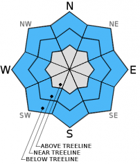
Below treeline, the avalanche danger is LOW, all aspects. Avalanche danger is MODERATE near and above treeline for both storm and wind slabs. Pockets of CONSIDERABLE danger exist above treeline for wind slabs primarily on NW-N-NE-E facing slopes. Some cross loading on W and SE aspects is possible. Slopes steeper than 37 degrees should be most suspect. Evaluate snow and terrain carefully, identify features of concern. Conservative decision making, careful snowpack evaluation essential above treeline.


Avalanche Problem 1: Wind Slab
-
Character ?

-
Aspect/Elevation ?

-
Likelihood ?CertainVery LikelyLikelyPossible
 Unlikely
 -
Size ?HistoricVery LargeLargeSmall

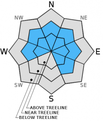
New wind slabs have formed near and above treeline with the 10-15 inches of new snow received yesterday that was accompanied with moderate southerly winds. Slabs will likely be small to medium in size and depth and certainly big enough to bury a person. Winds have eased since midnight though will pick up slightly later today with gusts to 35 mph in exposed areas, blowing primarily out of the southwest. Wind loaded aspects are, but not limited to, NW-N-NE-E facing slopes. Some SE and W slopes have likely seen some cross-loading as well. Both typical wind loaded zones below ridge tops, and non-typical mid-slope starting zones on slopes 37 degrees and steeper should be most suspect near and above treeline. Watch for obvious signs of wind slab formation. Becoming able to identify wind drifted snow is an important skill to have for winter backcountry travel. Cornice formations, wind pillows, hollow sounding-hard snow, visible blowing snow and snow surface patterns are very good indicators of potential wind loading.
Avalanche Problem 2: Storm Slab
-
Character ?

-
Aspect/Elevation ?
-
Likelihood ?CertainVery LikelyLikelyPossible
Unlikely
-
Size ?HistoricVery LargeLargeSmall
New storm slabs have developed with the 7-15 inches of new snow with yesterday's storm in protected areas below and near treeline. Above treeline, moderate to strong southerly winds limited the development of storm slabs. For today, mid to late afternoon will present the best time for any remaining storm slab instability with rising temperatures. New snow has fallen on top of the widespread rain crust that formed on Monday. A thin 2-5 cm layer of lighter density snow sits between the heavy new snow and the rain crust underneath. A storm slab avalanche occurred yesterday on the steep NW aspect of Grey Butte. It slid on top of the rain crust which acted as the perfect bed surface with the thin layer of lighter density snow acting like grease. For today, slopes 37 degrees and steeper near and below treeline will be the most suspect for any remaining storm slab instabilities. Evaluate snow and terrain carefully.
Avalanche Problem 3: Cornice
-
Character ?

-
Aspect/Elevation ?
-
Likelihood ?CertainVery LikelyLikelyPossible
Unlikely
-
Size ?HistoricVery LargeLargeSmall
Cornices of varying size have formed along ridge tops hanging over leeward, wind loaded aspects. Give them plenty of space and use them to help identify wind loaded areas and aspects. They can break off the terrain suddenly and pull back onto the ridge top and catch people by surprise, even on flat ground above the slope. Even small cornices have enough mass to be destructive and deadly. Cornice failure can trigger wind slab or storm slab avalanches.
Forecast Discussion
Over the next several days a long wave trough will send several short waves of weather over our area. Currently, a short wave ridge will provide us with a short break between systems today through this evening. Partly sunny skies will allow for good visibility above treeline. As the long wave trough edges closer to the coast it will be moving toward an amplifying ridge which will keep the chances of any significant amounts of precipitation for our area low until Thursday night. Thursday evening will see the development of heavier precipitation as a stronger wave passes over. Snow levels will hover between 6,000-7,000 feet with Thursday's system, and begin to lower Friday into Saturday dropping to 4,000-5,000 feet. Southerly winds will be light , but occasionally gusty, for today near treeline. Winds will increase on Thursday afternoon with the approaching storm system.
THIS SEASON PRECIPITATION: Since October 1st (the wet season), we have received 18.30 inches of water, normal is 19.69 inches, putting us at 92% of normal. For the month of January and year of 2016 we've received 8.81 inches of water, normal is 4.48 inches, putting us at 196% of normal
Recent Observations
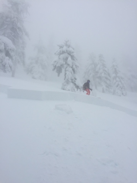
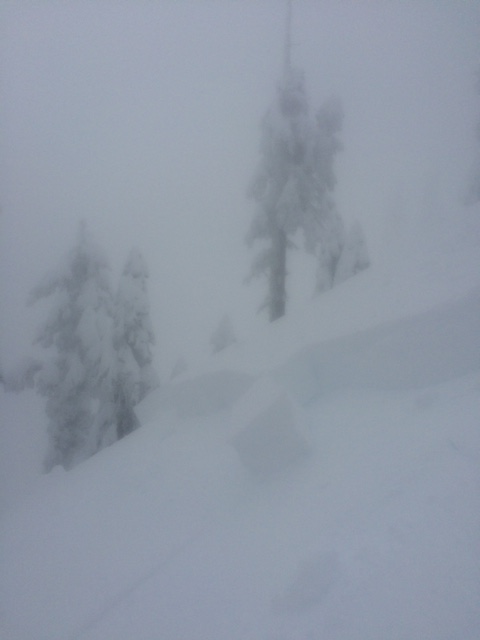
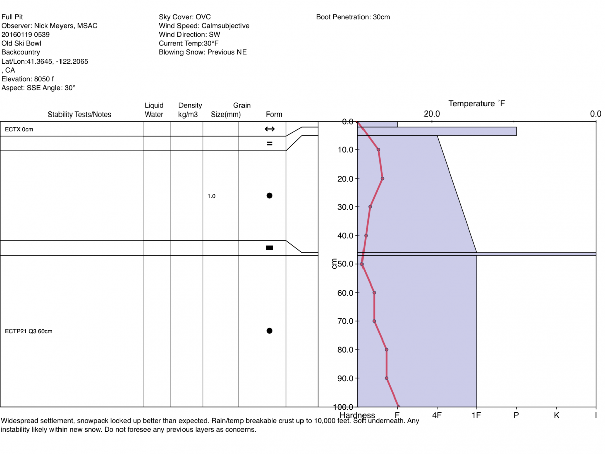
Now, that was a little intense! 7-15 inches of new snow fell over a short period of time (approximately 12 hours) yesterday at elevations of 5,500 ft and above. For six hours straight, between a tenth of an inch to just under a quarter of an inch of water fell per hour from 6 am to just before noon. With that amount of heavy snow fall that quickly, it is no wonder we saw some avalanche instability on a steep open slope yesterday. An avalanche was reported on the NW aspect of Grey Butte on a steep slope over 35 degrees. It is not known whether the avalanche was naturally triggered or remotely skier triggered by the reporting party. What is known is that the slide consisted of approximately 15-18 inches of new snow with Monday's rain crust acting as a perfect bed surface underneath. A 3-5 cm layer of lighter density snow that sits between the rain crust and the heavy new snow may have acted like "grease" between the consolidated, heavy storm slab and the pencil density of the crust. A thick fog rolled in around noon that may have helped to further saturate the heavy new snow. As we all know, the snowpack does not like rapid change. 15 inches of new snow over 12 hours with a thin layer of lighter snow over a slick, dense crust is the perfect recipe for a slide. Some shooting crack were also reported on the more southerly aspect as the reporting party skinned uphill.
The chances of a similar slide today will likely be at their highest with rising temperatures this afternoon, and any sun exposure. The break in wet weather today and slightly warmer temperatures will help to settle the new snow. Bonding with the crust layer beneath will begin to take place. Open slopes near or just below treeline at elevations above 7,000 feet will still hold the possiblity of human triggered avalanches while natural avalanches will be unlikely. Wind loaded, leeward W-NW-N-NE-E-SE aspects near and above treeline on 37 degree slopes and steeper will be the most suspect today. Carefull snowpack and terrain evaluation will be essential. Identify features of concern and avoid them. Pockets of consdierable avalanche danger on leeward aspects near and above treeline will make cautious route finding and conservative decision-making mandatory.
Concerns for any existing weak layers below the new snow received are minimal. Snow stability seemed very good below treeline from observations made yesterday from members of the public who ventured up Green Butte ridge. Any avalanche danger will lie within the new snow we just received on open slopes near and above treeline for wind and storm slabs. Travel should still call for standard caution when wind loaded features, large snow pillows, leeward ridge lines and hollow sounding slabs are encountered. As for any storm slabs, only the new snow on top of the 3cm rain crust should be a concern for the storm slab avalanche problem. Cornices still remain and some are probably getting pretty big!
Remember, your skin track up the hill is just as important as your ski line down. Choose safe up tracks... don't just follow the skin track that is set if you're not comfortable with the route. Breaking trail is a lot easier than getting caught in an avalanche. Also, tracks on a slope does NOT mean the slope is safe.
Only one at a time on a given slope. Use safe zones and make sure they are safe! Use good communication between group members. Avoid large groups. Talk about your route plan for the day and be ready to adjust your plan as you notice unstable snow such as shooting cracks, whumphing, recent avalanches, and/or rapid accumulation of snow.
_______________________________________________________________________________________________________________________________________________
LOCAL AREA ROAD, NORDIC and SNOWMOBILE PARK STATUS:
The Sand Flat cross country ski trails are in great shape and ready for your cross country skis or snow shoes. These are backcountry trails marked with blue diamonds on trees. Trails are not groomed. Snow shoers, please blaze a parallel trail to cross country skiers staying out of the skin track. These trails can be accessed via the Everett Memorial Highway. Thank you, and enjoy!
The Mt Shasta Nordic Center is open! These beautiful, groomed trails can be accessed via the Ski Park Highway. http://www.mtshastanordic.org
The Pilgrim Creek & Deer Mountain Snowmobile Parks are open! Trails are being groomed currently. Head to our "Education" tab on our website and find the snowmobile section for trail information, grooming status and other sledder resources!
The Castle Lake road is plowed to the Vista Point. The Everett Memorial Highway is plowed to Bunny Flat.
The Five Red Flags of Avalanche Danger any time of year include: 1) Recent/current avalanche activity 2) Whumphing sounds or shooting cracks 3) Recent/current heavy snowfall 4) Strong winds transporting snow 5) Rapid warming or rain on snow.
Weather and Current Conditions
Weather Summary
Good Morning! In Mt Shasta City at 0500, we have a current temperature of 32 F, ten degrees cooler than yesterday at this time, with overcast skies and calm wind.
On Mt Shasta (South Side) in the last 24 hours...
Old Ski Bowl - 7,600 feet, the current temperature is 19 degrees F. Snow on the ground totals 110 inches with 11inches new snow and 3 inches settlement. Temperatures have ranged from 19 F to 31 F.
Grey Butte - 8,000 feet, the current temperature is 18 degrees F. Temperatures have ranged from 18 F to 30 F. Winds have been averaging 19 mph, variable in nature with a max gust to 49 mph, west/northwest.
Mt Eddy Range (West side of Interstate-5)...
Castle Lake - 5,600 feet, the current temperature is 28 degrees F. Temperatures have ranged from 25 F to 35 F. Snow on the ground measures 68 inches with a 7 inches of new snow and 3 inches settlement.
Mt Eddy - 6,500 feet, the current temperature is 21 degrees F. Temperatures have ranged from 19 F to 32 F. Snow on the ground measures 82 inches with 9 inches of new snow and 2 inches of settlement. Winds have averaged 2 mph, southerly in direction with a max gust of 13 mph, south.
Always check the weather before you attempt to climb Mt Shasta. Further, monitor the weather as you climb. Becoming caught on the mountain in any type of weather can compromise life and limb. Be prepared.
| 0600 temperature: | 23 |
| Max. temperature in the last 24 hours: | 33 |
| Average wind direction during the last 24 hours: | Variable |
| Average wind speed during the last 24 hours: | 15-20 mi/hr |
| Maximum wind gust in the last 24 hours: | 49 mi/hr |
| New snowfall in the last 24 hours: | 7 inches |
| Total snow depth: | 91 inches |
Two Day Mountain Weather Forecast
Produced in partnership with the Medford NWS
| For 7000 ft to 9000 ft | |||
|---|---|---|---|
|
Wednesday (4 a.m. to 10 p.m.) |
Wednesday Night (10 p.m. to 4 a.m.) |
Thursday (4 a.m. to 10 p.m.) |
|
| Weather | Partly sunny with a 20% chance of snow after 10 am | Mostly cloudy with a slight chance of snow before 10 am, then a slight chance of rain and snow. Chance of precipitation is 20% | Mostly cloudy with a slight chance of snow before 10 am, then a chance of rain and snow after 4 pm. Chance of precipitation is 30%. Breezy |
| Temperature (°F) | 34 | 28 | 41 |
| Wind (mi/hr) | Southwest 10-15 mph with gusts to 35 mph this afternoon. | Southwest 10-15 mph | Southwest 10-15 mph increasing to 15-25 mph in the afternoon |
| Precipitation SWE / Snowfall (in) | / 0 | / 0 | / 0-.5 |
| For 9000 ft to 11000 ft | |||
| Wednesday | Wednesday Night | Thursday | |
| Weather | Partly sunny with a 20% chance of snow after 10 am. Windy with wind chill values as low as zero. | Mostly cloudy with a 20% chance of snow. Windy | Mostly cloudy with a slight chance of snow before 10 am, then a chance of snow after 4 pm. Chance of precipitation is 30%. Windy |
| Temperature (°F) | 26 | 26 | 28 |
| Wind (mi/hr) | West 20-25 mph with gusts to 35 mph | Southwest 0 | South 20-25 mph increasing to 30-35 mph in the afternoon with gusts to 50 mph |
| Precipitation SWE / Snowfall (in) | / 0 | / 0 | / 0-.5 |

