

You are here
Avalanche Advisory for 2016-01-23 07:08:57
- EXPIRED ON January 24, 2016 @ 7:08 amPublished on January 23, 2016 @ 7:08 am
- Issued by Nick Meyers - Shasta-Trinity National Forest
Bottom Line
Approximately 2 feet of new snow has fallen over the past 48 hours accompanied by breezy southwesterly wind.
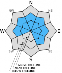
Near & above treeline, overall CONSIDERABLE avalanche danger is expected for slopes steeper than 35 degrees, all aspects. Pockets of HIGH danger are possible NW-N-NE-E aspects.
Below treeline, MODERATE avalanche danger exists. Natural wind and storm slab avalanche activity is possible today. Human triggered avalanches are likely, small to large in size.


Avalanche Problem 1: Wind Slab
-
Character ?

-
Aspect/Elevation ?
-
Likelihood ?CertainVery LikelyLikelyPossible
 Unlikely
 -
Size ?HistoricVery LargeLargeSmall

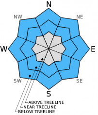
New wind slabs have begun to form with the the recent blast of new snow and associated moderate to strong southerly winds. Wind slabs that are forming near and above treeline will only get thicker during the remainder of today's storm. Slabs could be small to large in size and depth and could easily bury a person if triggered. The sensitivity of wind slabs to failure is uncertain. Best to stay off of them for now. Wind loaded aspects are, but not limited to, NW-N-NE-E facing slopes. Some SE and W slopes have likely seen some cross-loading as well. Both typical wind loaded zones below ridge tops, and non-typical mid-slope starting zones on slopes 35 degrees and steeper should be most suspect near and above treeline. Watch for obvious signs of wind slab formation which typically take the form of wind pillows, hollow sounding-hard snow, visible blowing snow and snow surface patterns, and areas underneath cornice formations.
Avalanche Problem 2: Storm Slab
-
Character ?

-
Aspect/Elevation ?
-
Likelihood ?CertainVery LikelyLikelyPossible
Unlikely
-
Size ?HistoricVery LargeLargeSmall
New storm slabs are developing with the significant amount of new snow received over the past 48 hours. Near treeline, in areas of partially open/protected trees will be the best place for storm slabs. Moderate to strong southerly winds will limit storm slab formation above treeline. The new snow that has fallen rests on top of a sun/melt-freeze crust that formed on Wednesday. This crust may act as a bed surface for the new snow on top. For today, it will be best to stay off of open slopes near treeline that are steeper than 35 degrees. .
Avalanche Problem 3: Cornice
-
Character ?

-
Aspect/Elevation ?

-
Likelihood ?CertainVery LikelyLikelyPossible
Unlikely
-
Size ?HistoricVery LargeLargeSmall
Cornice formations are abundant along ridge tops and should be given a wide berth while traveling in close proximity. They range from small wind lips of soft snow to large overhangs of hard snow. They can break off the terrain suddenly and pull back onto the ridge top catching people by surprise. Even small cornices have enough mass to be destructive and deadly. With the significant amount of snow already received and more on the way, cornices will only build in size. It is possible for cornice failure to trigger a wind slab avalanche on wind loaded slopes beneath it.
Forecast Discussion
The current storm over the area has packed a punch with heavy precipitation and south/southwest winds. A nice looking low pressure system, while not very wet, will generate waves of precipitation today. The storm will ease off as the day progresses, however we are still in for a bit more rain and snow this morning, lingering into the afternoon. South to southwest winds are peaking this morning and will diminish with the precipitation. It was trying to snow this morning at 4,000 feet but snow levels are more like 4,500 to 5,000. Snow levels may lower to town at times though we won't see much accumulation. Gusts up to 50 mph have been recorded at 8,000 feet on the south side of Mt Shasta, averaging 15-20 mph. All this new snow with wind will create potentially dangerous avalanche conditions in the backcountry today.
THIS SEASON PRECIPITATION: Since October 1st (the wet season), we have received 20.84 inches of water, normal is 20.35 inches, putting us at 102% of normal. For the month of January and year of 2016 we've received 11.35 inches of water, normal is 5.14 inches, putting us at 220% of normal .
Recent Observations
The forecast area has not seen any widespread instability this season, however we have had consistent avalanches occuring in isolated zones across the forecast area. Some frequent producers of avalanches are the open, NW aspect of Gray Butte, northerly aspects above Castle Lake, east/northeast aspects on Ash Creek Butte, Sun Bowl and Powder Bowl on Mt Shasta. We've also seen some longer running point release slides occur from the upper slopes of Mt Shasta. Spacial variability is always a difficult thing to deal with however all these slopes have a few things in common: wind loaded, near treeline, 35-38 degrees slope angle. While of course avalanches will not be limited to these areas, they are good "indicator" slide paths and great signs that avalanche danger is present. It's safe to say that as we get more snow and wind storms throughout the winter, avalanches will continue to occur.
Several winters of poor precipitation perhaps have some of us complacent with our backcountry situational awareness. Beacon practice, safe travel techniques and being able to identify avalanche terrain is paramount. With a normal winter upon us, more frequent avalanche occurance should be expected and it is going to be very important to be on your game each and every day you head out into the backcountry. The snowpack has experienced many changes from cold to warm temperatures, rapid accumulation of snow at times, high wind, surface hoar formations, etc. The avalanche danger on Mt Shasta can be different than at Castle Lake or in the Eddy Range. Much of the terrain on Shasta is fairly simple terrain to navigate. Castle Lake, on the other hand, while short vertical relief, is complex terrain. In complex terrain, a blissful low angle ski can quickly become a convex rollover into a terrain trap. We cannot express to you enough that yes, it is important to read the avalanche advisory in the morning... BUT, it is even more important to be able to confidently travel and make decisions in the backcountry, to ski or not ski a slope based on real observations of the current terrain, weather and snowpack AND...be able to manage the trickiest variable of them all, the human factor. Powder fever is REAL and can be life threatening.
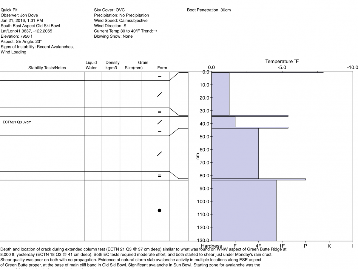
We have not been able to produce unstable results with tests in the lower layers of the snowpack. Moderate failures however, have been produced in top 30-40 cm of the snowpack over the week. This raises a good bit of concern as "moderate" is right in the middle. Most avalanche accidents happen at moderate or considerable avalanche danger. That is when the skiing is the best, but that's also when there is much uncertainty. Is the snow moderately stable or moderately un-stable? Moderate failures with the added 1-2 feet of new snow over the past 48 hours could have the camel's back begging for mercy... and you could be the straw.
For today, the scenario is pretty clear: We've had a good dollup of snow over a short period of time with cranking southwesterly winds. Wind and storm slabs are certain. A couple crust layers near the top layers of the snowpack could act as the bed surface for new wind and storm slabs. Wind can deposit snow onto leeward slopes 10x faster than falling snow. This means potentially thick wind slabs with serious consequence should you hit the sweet spot. Storm slabs will lurk and near treeline slopes will be the best place for storm slabs. Above treeline is always tricky... sometimes the wind simply blows the snow away. Wind loaded, mid slope starting zones in gullies are common on Shasta as ridgelines typically get blasted. Leeward ridgelines should always be suspect, pretty standard, but mid-slope starting zones can be stumbled upon without warning as you ski down a seemingly nice looking bowl or gully. Fortunately, many mid-slope starting zones are not that steep, but mid-slope, wind loaded convexities (steep roll-overs) should be your "watch out" situation.
Remember, your skin track up the hill is just as important as your ski line down. Choose safe up tracks... don't just follow the skin track that is set if you're not comfortable with the route. Breaking trail is a lot easier than getting caught in an avalanche. Also, tracks on a slope does NOT mean the slope is safe.
Only one at a time on a given slope. Use safe zones and make sure they are safe! Use good communication between group members. Avoid large groups. Talk about your route plan for the day and be ready to adjust your plan as you notice unstable snow such as shooting cracks, whumphing, recent avalanches, and/or rapid accumulation of snow.
_______________________________________________________________________________________________________________________________________________
LOCAL AREA ROAD, NORDIC and SNOWMOBILE PARK STATUS:
The Sand Flat cross country ski trails are in great shape and ready for your cross country skis or snow shoes. These are backcountry trails marked with blue diamonds on trees. Trails are not groomed. Snow shoers, please blaze a parallel trail to cross country skiers staying out of the skin track. These trails can be accessed via the Everett Memorial Highway. Thank you, and enjoy!
The Mt Shasta Nordic Center is open! These beautiful, groomed trails can be accessed via the Ski Park Highway. http://www.mtshastanordic.org
The Pilgrim Creek & Deer Mountain Snowmobile Parks are open! Trails are being groomed currently. Head to our "Education" tab on our website and find the snowmobile section for trail information, grooming status and other sledder resources!
The Castle Lake road is plowed to the Vista Point. The Everett Memorial Highway is plowed to Bunny Flat.
The Five Red Flags of Avalanche Danger any time of year include: 1) Recent/current avalanche activity 2) Whumphing sounds or shooting cracks 3) Recent/current heavy snowfall 4) Strong winds transporting snow 5) Rapid warming or rain on snow.
Weather and Current Conditions
Weather Summary
Good Morning! In Mt Shasta City at 0500, we have a current temperature of 35 F, nine degrees cooler than yesterday at this time, with heavy rain at this time, trying to snow!
On Mt Shasta (South Side) in the last 24 hours...
Old Ski Bowl - 7,600 feet, the current temperature is 24 degrees F. Snow on the ground totals 124 inches with 9 inches new snow and little settlement. Temperatures have ranged from 23 F to 31 F.
Grey Butte - 8,000 feet, the current temperature is 23 degrees F. Temperatures have ranged from 22 F to 30 F. Winds have been averaging 15 mph, southerly in direction with a max gust to 49 mph, southwest.
Mt Eddy Range (West side of Interstate-5)...
Castle Lake - 5,600 feet, the current temperature is 28 degrees F. Temperatures have ranged from 28 F to 35 F. Snow on the ground measures 63 inches with 2-4 inches of new snow and 1-2 inches of settlement due to rain on snow.
Mt Eddy - 6,500 feet, the current temperature is 26 degrees F. Temperatures have ranged from 25 F to 33 F. Snow on the ground measures 89 inches with 11 inches new snow and little settlement. Winds have averaged 2 mph, southwest in direction with a max gust of 21 mph, southwest.
Always check the weather before you attempt to climb Mt Shasta. Further, monitor the weather as you climb. Becoming caught on the mountain in any type of weather can compromise life and limb. Be prepared.
| 0600 temperature: | 28 |
| Max. temperature in the last 24 hours: | 33 |
| Average wind direction during the last 24 hours: | Southerly |
| Average wind speed during the last 24 hours: | 15 mi/hr |
| Maximum wind gust in the last 24 hours: | 49 (Gray Butte) mi/hr |
| New snowfall in the last 24 hours: | 8 inches |
| Total snow depth: | 100 inches |
Two Day Mountain Weather Forecast
Produced in partnership with the Medford NWS
| For 7000 ft to 9000 ft | |||
|---|---|---|---|
|
Saturday (4 a.m. to 10 p.m.) |
Saturday Night (10 p.m. to 4 a.m.) |
Sunday (4 a.m. to 10 p.m.) |
|
| Weather | Snow, heavy at times, breezy, isolated thunder storms | A 50% chance of snow showers, mostly cloudy | A 50% chance of snow showers, mostly cloudy |
| Temperature (°F) | 31 | 23 | 31 |
| Wind (mi/hr) | South shifting to Southwest 15-25 mph decreasing to 10-15 mph in the afternoon. Gusts to 30-40 mph. | West/Northwest 5-10 mph | Southwest 5-10 mph |
| Precipitation SWE / Snowfall (in) | / 4-8 | / 0-1 | / 1-2 |
| For 9000 ft to 11000 ft | |||
| Saturday | Saturday Night | Sunday | |
| Weather | Snow, heavy at times, thunder storms possible, windy | A 50% chance of snow showers, mostly cloudy, windy | A 50% chance of snow, mostly cloudy, windy |
| Temperature (°F) | 13 | 12 | 21 |
| Wind (mi/hr) | Southwest 35-45 mph | West/Northwest 8-12 | West 20-30 mph |
| Precipitation SWE / Snowfall (in) | / 8-12 | / 0-1 | / 1-3 |

