

You are here
Avalanche Advisory for 2016-01-25 06:38:28
- EXPIRED ON January 26, 2016 @ 6:38 amPublished on January 25, 2016 @ 6:38 am
- Issued by Nick Meyers - Shasta-Trinity National Forest
Bottom Line
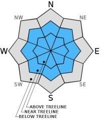
Today, MODERATE avalanche danger remains near and above treeline for small to medium sized wind slabs on all aspects. Slopes 37 degrees and steeper in complex terrain, convexities and cross loaded chutes will be the best place for human triggered wind slabs. Natural avalanche activity is unlikely.
LOW avalanche danger will exist below treeline.


Avalanche Problem 1: Wind Slab
-
Character ?

-
Aspect/Elevation ?
-
Likelihood ?CertainVery LikelyLikelyPossible
 Unlikely
 -
Size ?HistoricVery LargeLargeSmall

While we have few, new wind slab problems, existing wind slabs have been observed on all aspects near and above treeline in the forecast area. Wind slabs small to medium in size are bonding well to the old snow surface and concern for triggering a wind slab is diminishing.
The best place to trigger a wind slab today will be on steeper slopes, greater than 37 degrees, in complex terrain, steep chutes, convexities/roll overs, cross loaded couloirs. Slabs could be small to medium in size and involve enough snow to bury a person or sweep a rider into terrain traps and/or undesireable terrain.
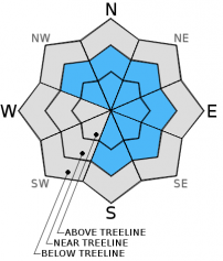
Avalanche Problem 2: Cornice
-
Character ?

-
Aspect/Elevation ?
-
Likelihood ?CertainVery LikelyLikelyPossible
Unlikely
-
Size ?HistoricVery LargeLargeSmall
The cornice factory has been in operation over the forecast area and small to large cornices observed along ridgelines. Most cornices have formed on leeward easterly facing slopes. Don't be surprised if you observe cornices on northwest and north facing slopes, as well as some south and southeast facing slopes. Along Green Butte Ridge on Mt Shasta, above Castle and Heart Lake on the west side and the northerly facing ridgeline above Cliff Lake are popular ski areas that see cornice formation often. The bottom line with cornices: they can break off and take you with them. If the cornice is to trigger an avalanche on the slope below - you, the cornice AND the snow avalanche are going for a ride. Stay on terra firma by observing rocks and trees poking through the snow or if there are no signs of ground, just simply stay way back from the edge.
Forecast Discussion
Yesterday was a bit of a surprise as lingering snow showers sure did linger! Not a ton of new snow, however a couple inches accumulated over the forecast area during the course of the day and created for some good skiing. Weather wise, not to much to mention today. A downright gorgeous day likely with very little wind and clear skies, something we havn't had much of this winter...there are zero complaints in the complaint department regarding that! Enjoy the Vitamin D, but be prepared for increasing clouds on Tuesday and another round of storms for later in the week. A warm front will begin to push in tomorrow and raise daytime highs at 7,000 feet to the mid 40's. Behind the warm front, inches of rain is expexted late Thursday and the part that make me cringe, 8 to 9,000 foot snow levels. Enough about that sad news. Enjoy the sun today and be safe out there.
THIS SEASON PRECIPITATION for MT SHASTA CITY: Since October 1st (the wet season), we have received 21.53 inches of water, normal is 20.79 inches, putting us at 103% of normal. For the month of January and year of 2016 we've received 12.04 inches of water, normal is 5.58 inches, putting us at 215% of normal .
Recent Observations
All snow depth sensors in the forecast area reported calm winds and about 2 inches of new snow from the lingering snow showers yesterday. Very calm winds allowed the new snow to evenly distribute and created darn good riding conditions in multiple areas. We have not observed or heard of any signs of instability over the forecast area in the last few days. The snowpack continued to settle about 1 inch yesterday and bonding between snowpack layers is improving.
Previous wind loading from this past weeks storms is still evident. Small to large cornices have formed on ridgelines from SW-W-NW winds. And, as (almost) always, wind slabs are still present too. A local observer yesterday (1.24.16) noted wind slabs are soft and bonding well to the old snow surface at 8,800 feet on Mt Shasta, west/southwest aspect, 33 degree slope. At this same location, extended column tests resulted in moderate failures with no propagation (ECTN13-Q3) and poor shear quality at 35cm down in snowpack on the old snow surface. No facets were observed at interfaces.
Storm slab concerns are diminishing and were not observed on Mt Shasta but could still be present at other locations below treeline in the forecast area. While one may stumble upon a small to medium sized storm slab today, it's unlikely to trigger. If one does find a storm slab, protected steeper (>37 degrees) slopes near treeline on shady northerly aspects will be the best place for said avalanche problem.
Lingering pockets of instability for wind loaded topography such as roll overs/convexities, steep chutes, and complex terrain with rock outcroppings will represent the best places for triggering a wind slab and should be todays primary concern. Near and above treeline, keep your peepers open for overhanging cornices on wind affected ridgelines and existing wind slabs which could be triggered when on slopes steeper than 37 degrees. Be able to observe signs of wind such as cornice formations, wind pillows and snow surface texture.
With the sun coming out today in full force, some roller balls and perhaps a point release or two are possible on southerly slopes during the warmest time of the day, usually mid afternoon. While any heat related, loose-snow point release avalanches are not a huge threat, they can still sweep you off your feet into trees, over a cliff, etc.
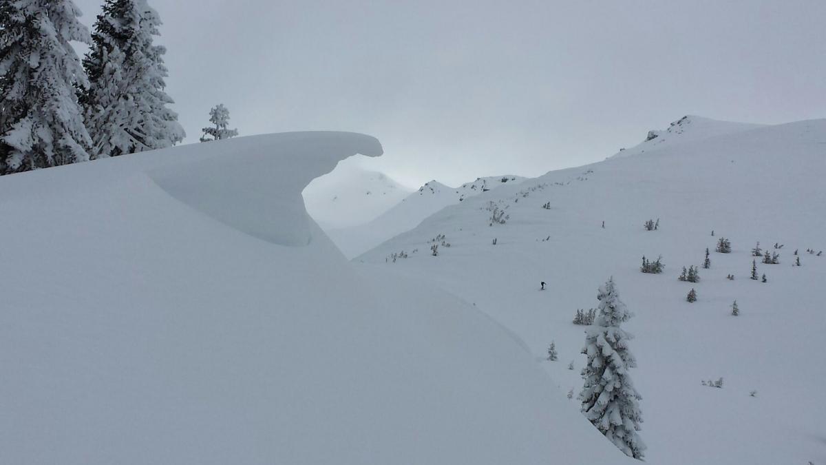
Cornice off a ridgeline on Mt Shasta, near treeline. This ridgeline runs north/south with the cornice facing east. Surfs up - Head high and glassy! [Photo: E.R.]
_______________________________________________________________________________________________________________________________________________
LOCAL AREA ROAD, NORDIC and SNOWMOBILE PARK STATUS:
The Sand Flat cross country ski trails are in great shape and ready for your cross country skis or snow shoes. These are backcountry trails marked with blue diamonds on trees. Trails are not groomed. Snow shoers, please blaze a parallel trail to cross country skiers staying out of the skin track. These trails can be accessed via the Everett Memorial Highway. Thank you, and enjoy!
The Mt Shasta Nordic Center is open! These beautiful, groomed trails can be accessed via the Ski Park Highway. http://www.mtshastanordic.org
The Pilgrim Creek & Deer Mountain Snowmobile Parks are open! Trails are being groomed currently. Head to our "Education" tab on our website and find the snowmobile section for trail information, grooming status and other sledder resources!
The Castle Lake road is plowed to the Vista Point. The Everett Memorial Highway is plowed to Bunny Flat.
The Five Red Flags of Avalanche Danger any time of year include: 1) Recent/current avalanche activity 2) Whumphing sounds or shooting cracks 3) Recent/current heavy snowfall 4) Strong winds transporting snow 5) Rapid warming or rain on snow.
Weather and Current Conditions
Weather Summary
Good Morning! In Mt Shasta City at 0500, we have a current temperature of 34 F, two degrees warmer than yesterday. Skies are obscured due to fog.
On Mt Shasta (South Side) in the last 24 hours...
Old Ski Bowl - 7,600 feet, the current temperature is 16 degrees F. Snow on the ground totals 125 inches with 2 inches new snow and 1 inch of settlement. Temperatures have ranged from 16 F to 27 F.
Grey Butte - 8,000 feet, the current temperature is 19 degrees F. Temperatures have ranged from 18 F to 26 F. Winds have been averaging 5-10 mph, west/northwest in direction with a max gust to 14 mph, west/northwest.
Mt Eddy Range (West side of Interstate-5)...
Castle Lake - 5,600 feet, the current temperature is 26 degrees F. Temperatures have ranged from 25 F to 38 F. Snow on the ground measures 68 inches with 2 inches new snow and 1 inch of settlement.
Mt Eddy - 6,500 feet, the current temperature is 20 degrees F. Temperatures have ranged from 18 F to 30 F. Snow on the ground measures 88 inches with 2 inches new snow and 1 inch settlement. Winds have averaged 3 mph, southerly in direction with a max gust of 5 mph, southwest.
Always check the weather before you attempt to climb Mt Shasta. Further, monitor the weather as you climb. Becoming caught on the mountain in any type of weather can compromise life and limb. Be prepared.
| 0600 temperature: | 23 |
| Max. temperature in the last 24 hours: | 33 |
| Average wind direction during the last 24 hours: | West/Northwest |
| Average wind speed during the last 24 hours: | 0-5 mi/hr |
| Maximum wind gust in the last 24 hours: | 14 mi/hr |
| New snowfall in the last 24 hours: | 1-2 inches |
| Total snow depth: | 102 inches |
Two Day Mountain Weather Forecast
Produced in partnership with the Medford NWS
| For 7000 ft to 9000 ft | |||
|---|---|---|---|
|
Monday (4 a.m. to 10 p.m.) |
Monday Night (10 p.m. to 4 a.m.) |
Tuesday (4 a.m. to 10 p.m.) |
|
| Weather | Mostly sunny | Mostly clear | Sunny |
| Temperature (°F) | 38 | 28 | 44 |
| Wind (mi/hr) | Southeast 0-10 mph | East/Northeast 0-10 mph | North/Northeast 0-10 mph |
| Precipitation SWE / Snowfall (in) | / 0 | / 0 | / 0 |
| For 9000 ft to 11000 ft | |||
| Monday | Monday Night | Tuesday | |
| Weather | Mostly sunny, breezy | Mostly clear | Mostly cloudy, windy |
| Temperature (°F) | 28 | 27 | 29 |
| Wind (mi/hr) | West, becoming northwest 20-30 mph in exposed locations | North/Northwest 0 | West 15-20 mph |
| Precipitation SWE / Snowfall (in) | / 0 | / 0 | / 0 |

