

You are here
Avalanche Advisory for 2016-01-26 06:57:42
- EXPIRED ON January 27, 2016 @ 6:57 amPublished on January 26, 2016 @ 6:57 am
- Issued by Nick Meyers - Shasta-Trinity National Forest
Bottom Line
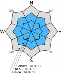
Above treeline, avalanche danger will remain MODERATE for small/medium size wind slabs on all aspects, loose snow avalanches on northerly aspects and roller balls on southerly aspects. Human triggered avalanches will be most likely on slopes steeper than 35 degrees. Large avalanches are unlikely, however small avalanches are possible.
Below and near treeline, the avalanche danger is LOW with isolated pockets of MODERATE danger for said avalanche problems.
Overall, normal caution is advised.


Avalanche Problem 1: Wind Slab
-
Character ?

-
Aspect/Elevation ?
-
Likelihood ?CertainVery LikelyLikelyPossible
 Unlikely
 -
Size ?HistoricVery LargeLargeSmall

While we have few, new wind slab problems, existing wind slabs have been observed on all aspects near and above treeline in the forecast area. Wind slabs small to medium in size are bonding well to the old snow surface and concern for triggering a wind slab is diminishing.
The best place to trigger a wind slab today will be on steeper slopes, greater than 35 degrees, in complex terrain, steep chutes, convexities/roll overs, cross loaded couloirs. Slabs could be small to medium in size and involve enough snow to bury a person or sweep a rider into terrain traps and/or undesireable terrain.
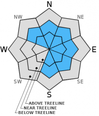
Avalanche Problem 2: Cornice
-
Character ?

-
Aspect/Elevation ?
-
Likelihood ?CertainVery LikelyLikelyPossible
Unlikely
-
Size ?HistoricVery LargeLargeSmall
The cornice factory has been in operation over the forecast area and small to large cornices observed along ridgelines. Most cornices have formed on leeward easterly facing slopes. Don't be surprised if you observe cornices on northwest and north facing slopes, as well as some south and southeast facing slopes. Along Green Butte Ridge on Mt Shasta, above Castle and Heart Lake on the west side and the northerly facing ridgeline above Cliff Lake are popular ski areas that see cornice formation often. The bottom line with cornices: they can break off and take you with them. If the cornice is to trigger an avalanche on the slope below - you, the cornice AND the snow avalanche are going for a ride. Stay on terra firma by observing rocks and trees poking through the snow or if there are no signs of ground, just simply stay way back from the edge.
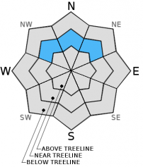
Avalanche Problem 3: Loose Dry
-
Character ?

-
Aspect/Elevation ?
-
Likelihood ?CertainVery LikelyLikelyPossible
Unlikely
-
Size ?HistoricVery LargeLargeSmall
Some small, loose-dry sluffs were skier triggered yesterday in the Castle Lake area. These sluffs were small and did not slide far. Only northerly, steep slopes (>35 degrees) near treeline with a long fetch where sluffs could build in size should be most suspect. Concern for this type of instability is low today, but worth mentioning. Sometimes, it doesn't take much to cause one to loose balance and take a tumble into trees, over a cliff or into a potentially dangerous terrain trap.
Forecast Discussion
A few clouds and a few short waves of weather creating light showers are possible over the next two days. Otherwise, today and tomorrow will be quiet as a ridge of high pressure continues to sit over the west coast. Another front waits off shore at 130W and this presents the next main weather focus. Late Wedesday night and Thursday the jetstream will aim toward Northern California and give us lock, stock and barrel to the tune of 2-3 inches of rain over a 2 day period (Thursday/Friday). The nasty rumor of 8 to 9,000 foot snow levels is partially true... Were looking at periods of high snow levels as mentioned, though a cold front is expected to move inland Friday and snow levels will drop to 5,500 feet. Snow levels are expected to drop to around 3,000 feet by Friday night. Gusty winds will precede the cold front... 50-60 mph winds won't be a surprise at the 700mb level (10,000 feet). Today, winds will be mostly calm and mixed skies.
THIS SEASON PRECIPITATION for MT SHASTA CITY: Since October 1st (the wet season), we have received 21.53 inches of water, normal is 21.00 inches, putting us at 102% of normal. For the month of January and year of 2016 we've received 12.04 inches of water, normal is 5.79 inches, putting us at 207% of normal .
Recent Observations
The snowpack continues to stabilize and settle in the forecast area due to a full day of sun yesterday. Another 4 inches of settlement was recorded at treeline on Mt Shasta and 2-3 inches on the west side over the past 24 hours. Snow conditions are going to depend largely on aspect and elevation. Southerly slopes for most elevations got warm yesterday and some roller balls were observed. Northerly slopes will still host supportable powder. Instabilities are going to be isolated to steep terrain and spacial variability will be the soup of the day. Todays conditions will mostly mirror yesterdays, minus southerly slopes which might have a bit of a crust this morning. Roller balls, failing cornices, small to medium size wind slabs and surface sluffing could all be encountered. Large, destructive avalanche are unlikely, however small avalanches are likely and could sweep somebody into terrain traps and/or undesireable terrain and could be enough to bury a person if in just the right spot. Lingering pockets of instability for wind loaded topography such as roll overs/convexities, steep chutes, and complex terrain with rock outcroppings will represent the best places for triggering wind slabs and surface sluffs and should be todays primary concern. Near and above treeline, keep your peepers open for overhanging cornices on wind affected ridgelines and existing wind slabs which could be triggered when on slopes steeper than 37 degrees. Be able to observe signs of wind such as cornice formations, wind pillows and snow surface texture.
Mt Shasta: Wind slab conditions near and above treeline are very close to day prior. Warming continues to help snowpack settle and wind slabs bond to old snow. Wind slabs still present on all aspects near and above treeline. Slabs stiff and better developed in Avalanche Gulch above 9,000 feet due to colder temps and consistent wind, compared to softer slabs found yesterday in Giddy Giddy Gulch (just above treeline, south side). On a S/SE aspect at 10,285 feet on Casaval Ridge (100 feet below Lake Helen), at 18cm deep, 1-2mm facets are developing from new precipitation particles on the old snow surface. However, slabs appear to be bonding well to a high friction, variable bed surface. Stability test results: ECTN12 Q3 / ECTN21 Q3 / Air temp: 28 F / No significant temperature grandient. Despite somewhat poor structure, the hypothesis is that the snowpack is gaining strength due to counteracting processes of sintering and faceting from temperature fluctuations. Snow settlement on the high friction bed surface created by wind also assisting. Skiing above 9,000 feet was typical "Shasta variable". Scoured pockets/ridges with deposited snow in gullies and depressions. Winds were gusting 25 mph, N/NW and trasported decent amounts of snow on S/SE aspects above 9,0000 feet on ridge lines.
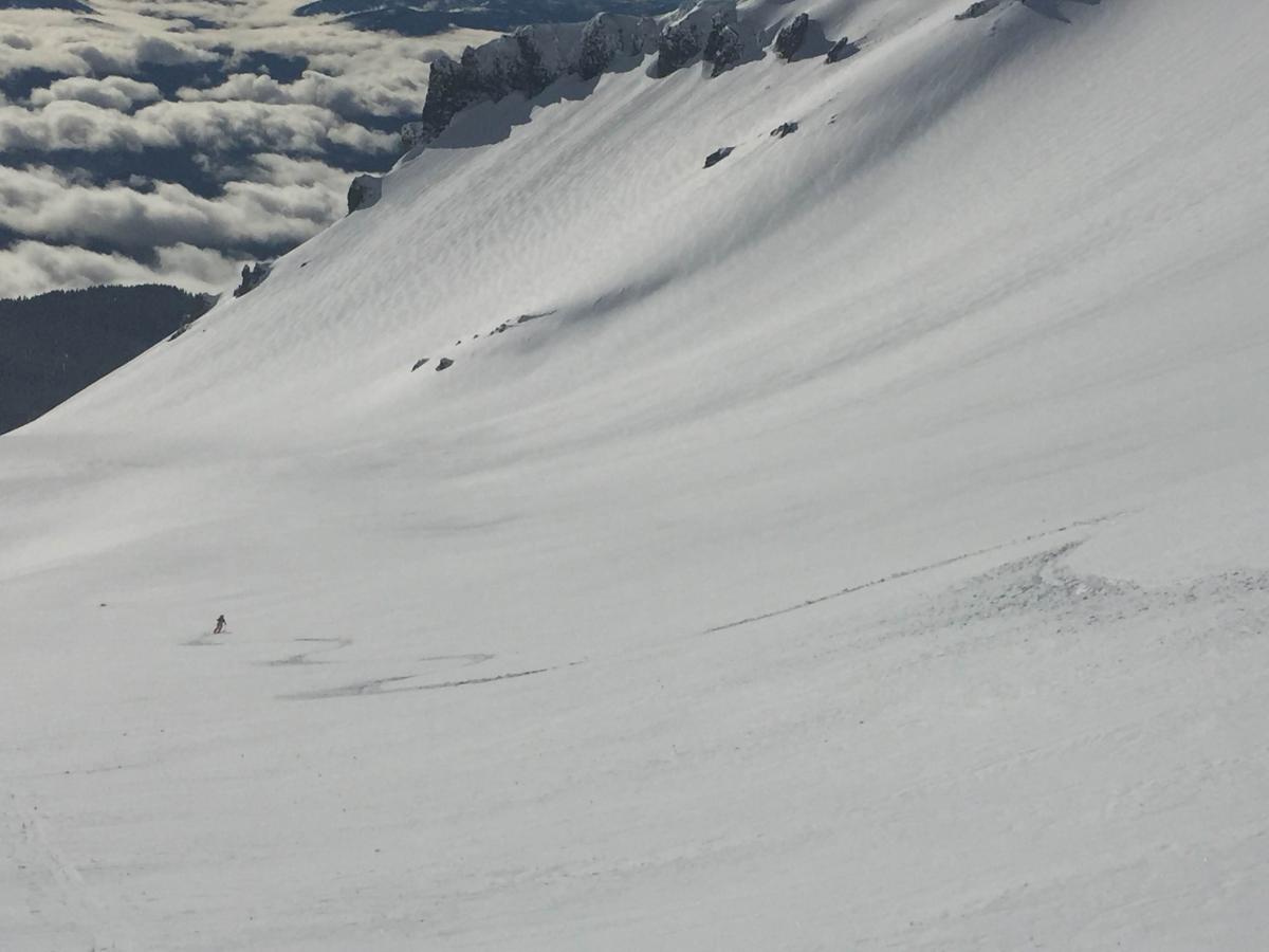
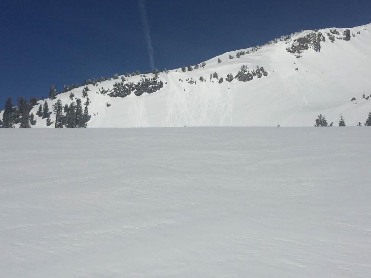
Photos: Left, Avalanche Gulch on 1/25/16 with Casaval Ridge in background. Right, some point release/roller ball activity off the lower portion of Casaval Ridge into Avalanche Gulch.
Castle Lake: Great skiing was reported from the Castle Lake area yesterday with pockets of instability in the form of cornice failure, surface sluffing, and small wind/soft slabs. Spacial variability will continue to be the name of the game today. Castle Lake has complex terrain. Steep rollovers, chutes and rocky outcrops can host pockets of instability. The entire north facing ridgeline above Caslte Lake can shed cornices and trigger slides below.
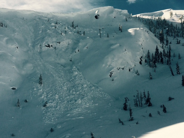
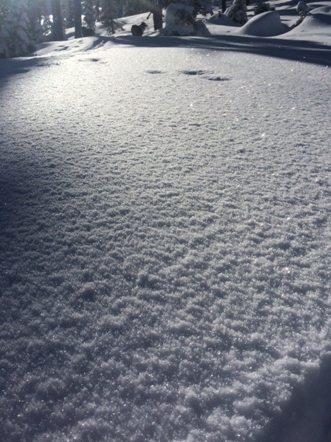
Photos: Left, ridgeline above Castle Lake, cornice failure causing slide. Right, surface hoar observed on northern ridgeline on "Right Peak".
East Side: Observations from the east side of the forecast area, east of Mt Shasta... Upper snowpack "right side up" with density change from fist to four finger approximately 15cm deep and continuing from four finger to one finger density at approximately 40-45 cm deep. No crust layers were observed in top 100-120 cm of snow. Extended column test on a north aspect at 7,300 feet of ECTX. Recent avalanche activity included a small point release on a southeast aspect below a rock outcropping. Some afternoon roller balls observed on a south aspect near treeline. A skier triggered, small loose-dry sluff on steep terrain occurred as well as another skier triggered small, isolated wind slab on a 37 degree slope. The wind slab was on a north aspect, near treeline with an eight inch crown, approximately 15 feet wide and slid about 20 feet.
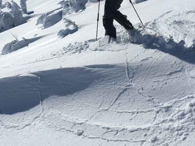
Photo: A small wind slab, mid-fracture, along ridgeline, east side
_______________________________________________________________________________________________________________________________________________
LOCAL AREA ROAD, NORDIC and SNOWMOBILE PARK STATUS:
The Sand Flat cross country ski trails are in great shape and ready for your cross country skis or snow shoes. These are backcountry trails marked with blue diamonds on trees. Trails are not groomed. Snow shoers, please blaze a parallel trail to cross country skiers staying out of the skin track. These trails can be accessed via the Everett Memorial Highway. Thank you, and enjoy!
The Mt Shasta Nordic Center is open! These beautiful, groomed trails can be accessed via the Ski Park Highway. http://www.mtshastanordic.org
The Pilgrim Creek & Deer Mountain Snowmobile Parks are open! Trails are being groomed currently. Head to our "Education" tab on our website and find the snowmobile section for trail information, grooming status and other sledder resources!
The Castle Lake road is plowed to the lake. The Everett Memorial Highway is plowed to Bunny Flat.
The Five Red Flags of Avalanche Danger any time of year include: 1) Recent/current avalanche activity 2) Whumphing sounds or shooting cracks 3) Recent/current heavy snowfall 4) Strong winds transporting snow 5) Rapid warming or rain on snow.
Weather and Current Conditions
Weather Summary
Good Morning! In Mt Shasta City at 0500, we have a current temperature of 34 F, the same temperature as yesterday at this time. Skies are obscured due to fog.
On Mt Shasta (South Side) in the last 24 hours...
Old Ski Bowl - 7,600 feet, the current temperature is 30 degrees F, (14 degrees warmer than yesterday). Snow on the ground totals 121 inches with no new snow and 4 inches of settlement. Temperatures have ranged from 20 F to 39 F.
Grey Butte - 8,000 feet, the current temperature is 35 degrees F (16 degrees warmer than yesterday). Temperatures have ranged from 19 F to 37 F. Winds have been averaging 5-10 mph, NW for part of the day, then switching to easterly at 1500, with a max gust to 21 mph, northwest and east/northeast.
Mt Eddy Range (West side of Interstate-5)...
Castle Lake - 5,600 feet - The Castle Lake weather station is experiencing difficulties. We are working on fixing the problem. Castle Lake conditions can often be similar to the Mt Eddy conditions (below).
Mt Eddy - 6,500 feet, the current temperature is 31 degrees F (11 degrees warmer than yesterday). Temperatures have ranged from 20 F to 37 F. Snow on the ground measures 84 inches with no new snow and 4 inches settlement. Winds have averaged 1-2 mph, southerly in direction with a max gust of 7 mph, southwest.
Always check the weather before you attempt to climb Mt Shasta. Further, monitor the weather as you climb. Becoming caught on the mountain in any type of weather can compromise life and limb. Be prepared.
| 0600 temperature: | 24 |
| Max. temperature in the last 24 hours: | 33 |
| Average wind direction during the last 24 hours: | Variable |
| Average wind speed during the last 24 hours: | 0-5 mi/hr |
| Maximum wind gust in the last 24 hours: | 21 (Gray Butte) mi/hr |
| New snowfall in the last 24 hours: | 0 inches |
| Total snow depth: | 100 inches |
Two Day Mountain Weather Forecast
Produced in partnership with the Medford NWS
| For 7000 ft to 9000 ft | |||
|---|---|---|---|
|
Tuesday (4 a.m. to 10 p.m.) |
Tuesday Night (10 p.m. to 4 a.m.) |
Wednesday (4 a.m. to 10 p.m.) |
|
| Weather | Partly cloudy, becoming mostly cloudy | Mostly cloudy, slight chance of rain showers after midnight | Mostly cloudy, 20% chance of rain in the morning |
| Temperature (°F) | 42 | 29 | 43 |
| Wind (mi/hr) | East/Northeast 5 mph | Southeast 5-10 mph | Southeast 5-10 mph |
| Precipitation SWE / Snowfall (in) | / 0 | / 0 | / 0 |
| For 9000 ft to 11000 ft | |||
| Tuesday | Tuesday Night | Wednesday | |
| Weather | Partly cloudy, a 20% chance of snow showers before 10am | Mostly cloudy, a slight chance of snow showers before 4am, then a slight chance of snow after 4am., windy | Partly cloudy, a 20% chance of snow before 10am, windy |
| Temperature (°F) | 28 | 28 | 29 |
| Wind (mi/hr) | North 5-10 mph | Southwest 0 | Southwest 20-30 mph |
| Precipitation SWE / Snowfall (in) | / 0 | / 0 | / 0 |

