

You are here
Avalanche Advisory for 2016-01-27 07:11:00
- EXPIRED ON January 28, 2016 @ 7:11 amPublished on January 27, 2016 @ 7:11 am
- Issued by Jon Dove - Shasta-Trinity National Forest
Bottom Line
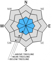
Above treeline, avalanche danger will remain MODERATE for small/medium size wind slabs on all aspects. Human triggered avalanches will be most likely on slopes 37 degrees and steeper in complex terrain. Evaluate snowpack and terrain carefully, identifying features of concern.
Below and near treeline, the avalanche danger is LOW on all aspects. Be aware of instabilities in the form of roller balls and pin wheels on southerly slopes, and cornice formations along ridge tops.


Avalanche Problem 1: Wind Slab
-
Character ?

-
Aspect/Elevation ?
-
Likelihood ?CertainVery LikelyLikelyPossible
 Unlikely
 -
Size ?HistoricVery LargeLargeSmall

While we have few, new wind slab problems, existing wind slabs have been observed on all aspects near and above treeline in the forecast area. Wind slabs small to medium in size continue bonding with the old snow surface and concern for triggering a wind slab is diminishing. The best place to trigger a wind slab today will be on slopes 37 degrees and steeper, in complex terrain, steep chutes, convexities/roll overs, tops of couloirs, and cross loaded depressions. Slabs could be small to medium in size and involve enough snow to bury a person or sweep a rider into terrain traps and/or undesirable terrain.
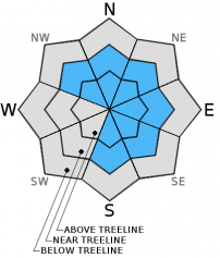
Avalanche Problem 2: Cornice
-
Character ?

-
Aspect/Elevation ?
-
Likelihood ?CertainVery LikelyLikelyPossible
Unlikely
-
Size ?HistoricVery LargeLargeSmall
Cornices have seen widespread formation along ridge tops throughout the forecast area developing in size from small to quite large. Most cornices have formed on leeward, easterly facing slopes. Don't be surprised if you observe cornices on northwest and north facing slopes, as well as some south and southeast facing slopes. Along Green Butte Ridge on Mt Shasta, above Castle and Heart Lake on the west side, and the northerly facing ridge line above Cliff Lake are popular spots that see cornice formation often. The bottom line with cornices: they can break off and take you with them. When traveling along ridge lines identify cornices, and give them plenty of space staying where you think the ridge top might exist if it were exposed ground. Cornice failure could also trigger an avalanche on the slope beneath it. Once again, stay on terra firma by observing rocks and trees poking through the snow, or if there are no signs of ground, just simply stay way back from the edge.
Forecast Discussion
Aside from a few high, thin clouds, today will offer another dose of sunshine underneath continued high pressure. A cold front offshore has taped into subtropical moisture and will lead an "atmospheric river" toward Northern California and Southern Oregon. Precipitation models forecast up to 1.44 inches of water for our area. Despite the classification as a cold front snow levels are predicted to rise significantly to around 8,000 ft. bringing rain to elevations above treeline Thursday afternoon. Snow levels will begin to drop Friday evening falling to around 4,000 ft. As the front moves over the area winds will increase coming out of the southwest with speeds reaching 50 mph at mid-mountain (10,000-11,000 ft.) elevations Thursday.
THIS SEASON PRECIPITATION for MT SHASTA CITY: Since October 1st (the wet season), we have received 21.53 inches of water, normal is 21.22 inches, putting us at 101% of normal. For the month of January and year of 2016 we've received 12.04 inches of water, normal is 6.01 inches, putting us at 200% of normal .
Recent Observations
Observations for yesterday are limited to information available from the four weathter stations, and little else. The snowpack continues to settle and stabilize throughout the forecast area with a second day of sunshine Tuesday, and a significant increase in temperature. Both Old Ski Bowl and Grey Butte weather stations recorded daytime high temperatures at 45 degrees yesterday! Those type of temperatures at 8,000 ft. have helped to round snow crystals and encourage bonding of snow layers. The snowpack settled another 2 inches over the course of the day. The warmer temperatures may have even had an impact on shaded, more northerly facing aspects limiting the presence of any loose dry snow instabilities similar to those witnessed on Monday. Snow on all aspects at elevations near and below 9,000 ft. have been affected by the yesterday's warmer temperatures.
Todays conditions will reflect a melt freeze cycle with possibly firm conditions, or even a thick crust this morning on southerly facing slopes. Small to medium size wind slabs above treeline could be encountered today, as well. Roller balls on southerly facing aspects, and failing cornices will also present snow conditions to watch out for. Wind slab instabilities will be isolated to slopes 37 degrees and steeper on W-NW-N-NE-E-SE aspects above treeline today. At mid-mountain (10,000 ft) elevations and higher, wind loaded pockets on topography such as roll overs/convexities, steep chutes, and complex terrain with rock outcroppings will represent the best places for triggering wind slabs. They will be todays primary concern. Large, destructive avalanche are unlikely, however small human triggered wind slab avalanches are possible, and could sweep somebody into terrain traps and/or undesirable terrain. Enough snow could be entrained to bury a person in just the right set of circumstances. Above treeline, keep aware for overhanging cornices on wind affected ridgelines. Continue to be cautious of wind slabs, and pay attention to evidence of wind loading or wind affected snow conditions.
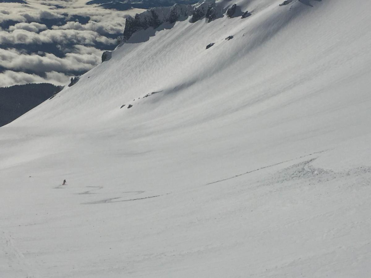
Photos: Left, Avalanche Gulch on 1/25/16 with Casaval Ridge in background. Right, some point release/roller ball activity off the lower portion of Casaval Ridge into Avalanche Gulch.
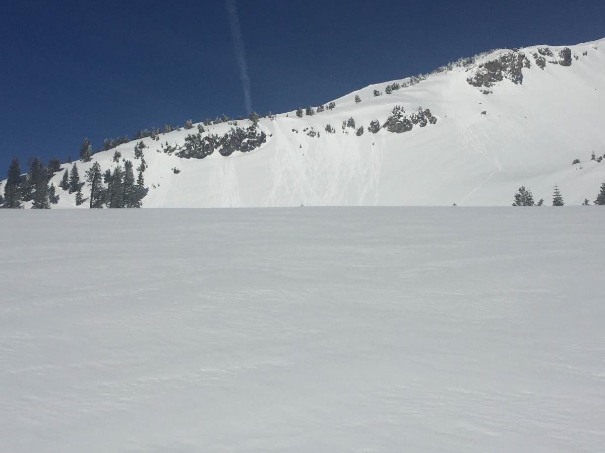
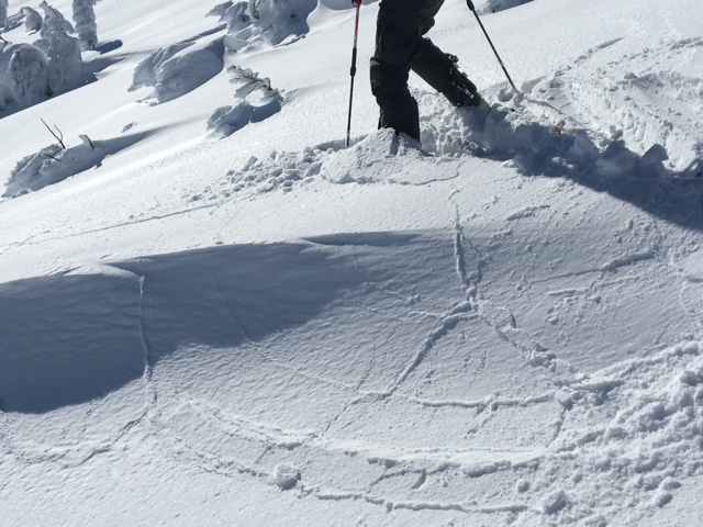
Castle Lake: Great skiing was reported from the Castle Lake area Tuesday with pockets of instability in the form of cornice failure, surface sluffing, and small wind/soft slabs. Spacial variability will continue to be the name of the game today. Castle Lake has complex terrain. Steep rollovers, chutes and rocky outcrops can host pockets of instability. The entire north facing ridgeline above Castle Lake can shed cornices and potentially trigger slides below.
Photos: Left, ridgeline above Castle Lake, cornice failure causing slide. Right, surface hoar observed on northern ridgeline on "Right Peak".
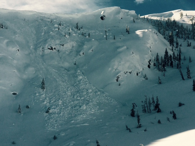
East Side: Observations on 1/25/2016 from the east side of the forecast area, east of Mt Shasta... Upper snowpack "right side up" with density change from fist to four finger approximately 15cm deep and continuing from four finger to one finger density at approximately 40-45 cm deep. No crust layers were observed in top 100-120 cm of snow. Extended column test on a north aspect at 7,300 feet of ECTX. Recent avalanche activity included a small point release on a southeast aspect below a rock outcropping. Some afternoon roller balls observed on a south aspect near treeline. A skier triggered, small loose-dry sluff on steep terrain occurred as well as another skier triggered small, isolated wind slab on a 37 degree slope. The wind slab was on a north aspect, near treeline with an eight inch crown, approximately 15 feet wide and slid about 20 feet.
Photo: A small wind slab, mid-fracture, along ridgeline, east side
_______________________________________________________________________________________________________________________________________________
LOCAL AREA ROAD, NORDIC and SNOWMOBILE PARK STATUS:
The Sand Flat cross country ski trails are in great shape and ready for your cross country skis or snow shoes. These are backcountry trails marked with blue diamonds on trees. Trails are not groomed. Snow shoers, please blaze a parallel trail to cross country skiers staying out of the skin track. These trails can be accessed via the Everett Memorial Highway. Thank you, and enjoy!
The Mt Shasta Nordic Center is open! These beautiful, groomed trails can be accessed via the Ski Park Highway. http://www.mtshastanordic.org
The Pilgrim Creek & Deer Mountain Snowmobile Parks are open! Trails are being groomed currently. Head to our "Education" tab on our website and find the snowmobile section for trail information, grooming status and other sledder resources!
The Castle Lake road is plowed to the lake. The Everett Memorial Highway is plowed to Bunny Flat.
The Five Red Flags of Avalanche Danger any time of year include: 1) Recent/current avalanche activity 2) Whumphing sounds or shooting cracks 3) Recent/current heavy snowfall 4) Strong winds transporting snow 5) Rapid warming or rain on snow.
Weather and Current Conditions
Weather Summary
Good Morning! In Mt Shasta City at 0500, we have a current temperature of 30 F, four degrees cooler than yesterday at this time. Skies are clear with calm wind.
On Mt Shasta (South Side) in the last 24 hours...
Old Ski Bowl - 7,600 feet, the current temperature is 33 degrees F, (3 degrees warmer than yesterday). Snow on the ground totals 119 inches with no new snow and 2 inches of settlement. Temperatures have ranged from 30 F to 45 F.
Grey Butte - 8,000 feet, the current temperature is 36 degrees F. Temperatures have ranged from 34 F to 45 F. Winds have been averaging 5-10 mph, with a max gust to 28 mph, east/northeast.
Mt Eddy Range (West side of Interstate-5)...
Castle Lake - 5,600 feet - The Castle Lake weather station is experiencing difficulties. We are working on fixing the problem. Castle Lake conditions can often be similar to the Mt Eddy conditions (below).
Mt Eddy - 6,500 feet, the current temperature is 33 degrees F. Temperatures have ranged from 29 F to 42 F. Snow on the ground measures 84 inches with no new snow and no new settlement. Winds have averaged 3 mph, west/southwest with a max gust of 6 mph, west/southwest.
Always check the weather before you attempt to climb Mt Shasta. Further, monitor the weather as you climb. Becoming caught on the mountain in any type of weather can compromise life and limb. Be prepared.
| 0600 temperature: | 29 |
| Max. temperature in the last 24 hours: | 38 |
| Average wind direction during the last 24 hours: | Variable |
| Average wind speed during the last 24 hours: | 5-10 mi/hr |
| Maximum wind gust in the last 24 hours: | 28 mi/hr |
| New snowfall in the last 24 hours: | 0 inches |
| Total snow depth: | 97 inches |
Two Day Mountain Weather Forecast
Produced in partnership with the Medford NWS
| For 7000 ft to 9000 ft | |||
|---|---|---|---|
|
Wednesday (4 a.m. to 10 p.m.) |
Wednesday Night (10 p.m. to 4 a.m.) |
Thursday (4 a.m. to 10 p.m.) |
|
| Weather | Mostly sunny | Becoming mostly cloudy with a 30% chance of rain, mainly after 4 am. | Cloudy. Rain, mainly after 10 am. Breezy |
| Temperature (°F) | 44 | 33 | 42 |
| Wind (mi/hr) | South 5-10 mph | South 5-10 mph | South 15-20 mph |
| Precipitation SWE / Snowfall (in) | / 0 | / 0 | / 0 |
| For 9000 ft to 11000 ft | |||
| Wednesday | Wednesday Night | Thursday | |
| Weather | Mostly sunny | Becoming mostly cloudy with a 30% chance of snow, mainly after 4 am. Windy | Cloudy. Snow, mainly after 10 am. Windy with wind chill values as low as -3. |
| Temperature (°F) | 30 | 29 | 29 |
| Wind (mi/hr) | Southwest 15-20 mph | Southwest 0 | West 45-50 mph |
| Precipitation SWE / Snowfall (in) | / 0 | / 0-.5 | / 1-3 |

