

You are here
Avalanche Advisory for 2016-01-28 06:57:25
- EXPIRED ON January 29, 2016 @ 6:57 amPublished on January 28, 2016 @ 6:57 am
- Issued by Jon Dove - Shasta-Trinity National Forest
Bottom Line
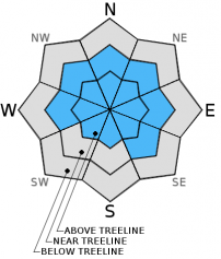
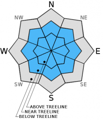
Overall, LOW avalanche danger exists below, near, and above treeline on all aspects. Pockets of MODERATE avalanche danger exist above treeline at elevations of 10,000 ft and above for wind slab formations below ridge tops and cornices, at the tops of chutes and couloirs, rock outcroppings, etc. Avalanche danger will increase near and above treeline for wind and storm slabs with today's storm. Normal caution is advised.


Avalanche Problem 1: Wind Slab
-
Character ?

-
Aspect/Elevation ?
-
Likelihood ?CertainVery LikelyLikelyPossible
 Unlikely
 -
Size ?HistoricVery LargeLargeSmall

Wind slab instabilities have been observed, but they exist in the usual locations below cornice formations and ridge tops. Wind slabs small to medium in size continue bonding with the old snow surface and concern for triggering a wind slab is diminishing. That being said, the approaching storm system today and Friday will bring heavy precipitation and moderately strong southerly winds. Snow levels will be high, hovering around 8,000 ft. bringing snow mostly to above treeline elevations. This will be the best place to find new wind slab formations. The most likely place to trigger a wind slab today will be at elevations above 10,000 ft., on slopes 37 degrees and steeper, in complex terrain, steep chutes, convexities/roll overs, tops of couloirs, and cross loaded depressions. Slabs will build in size and depth primarily on leeward W-NW-N-NE-E-SE aspects with the coming storm.
Avalanche Problem 2: Storm Slab
-
Character ?

-
Aspect/Elevation ?
-
Likelihood ?CertainVery LikelyLikelyPossible
Unlikely
-
Size ?HistoricVery LargeLargeSmall
Storm slabs will developed at elevations around 8,000 ft. and above with the coming storm system. The moderately strong southerly winds will limit the amount of storm slab development above treeline. Storm slabs will still be a concern, however, with the significant amount of snow forecast for elevations above the snow line.
Forecast Discussion
Cloud cover will increase this morning as the incoming cold front makes land fall and rolls our way. Precipitation will begin to fall around mid-day as the front begins to pass over the area. For today, precipitation amounts are forecast to be between a quarter of an inch,and a half of an inch of water. Snow levels are predicted to hover around 8,000 ft. The front is set to return on Friday, this time as a warm front. It will provide for another round of rain and snow. Precipitation amounts for Friday's system will fall between three quarters of an inch, and an inch of water. Snow levels will drop slightly overnight to 6,500-7,000 ft., then rise again Friday morning. Levels will, however, remain near or below 8,000 ft. Moderately strong southerly winds will accompany today's storm, with winds at mid-mountain (10,000 ft.) blowing around 50 mph out of the southwest. Winds will remain at this level throughout both waves of weather over the next 36 hours.
THIS SEASON PRECIPITATION for MT SHASTA CITY: Since October 1st (the wet season), we have received 21.53 inches of water, normal is 21.43 inches, putting us at 100% of normal. For the month of January and year of 2016 we've received 12.04 inches of water, normal is 6.22 inches, putting us at 193% of normal .
Recent Observations
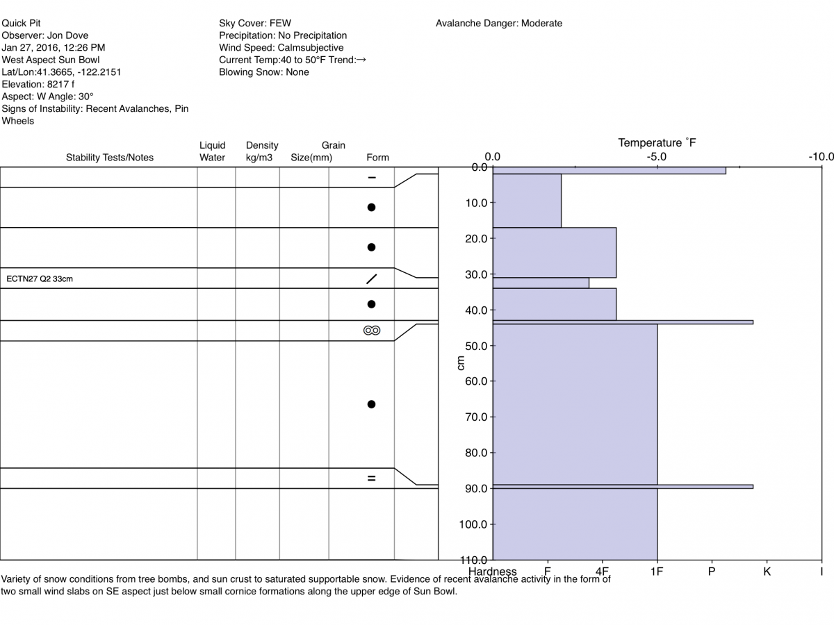
Sunny skies and relatively warm temperatures for a January day made for an enjoyable ski tour yesterday. A variety of snow conditions were observed as I set out to find wind slab formations, and any evidence of avalanche activity. Below treeline, the ample amount of snow that had collected in the tree canopy has made for a sizable stockpile of tree bombs. A halo of wet and disturbed snow surrounds each Red Fir breaking up the surface of the snowpack. A sun/melt freeze crust was found on south to southwest aspects below, near, and above treeline. The snow on southeast facing aspects was saturated, heavy, and supportable with all the solar heat gain during the day. There was some evidence found of recent snow instabilities in the form of roller balls and a two small wind slab avalanches, both on southerly facing aspects above treeline. A snow study pit was dug on a west facing aspect with a 30 degree slope at 8,200 ft. The snowpack at this location had a layer of slightly less dense snow laying between more dense layers approximately 32 cm deep. The layer of less dense snow was composed of decomposing stellars and dendrites with the layers both above and below composed of rounded grains. An extended column test was performed resulting in a score of ECTN27 Q2 at 33 cm deep. The evidence of failure during the ECT was simply the appearance of a crease at the layer of slightly less dense snow highlighting its presence.
For today, avalanche danger for wind slabs above treeline had been decreased due to the effects of the weather over the last couple days. Warm daytime temperatures and abundant sunshine have helped to round snow grains and encourage bonding of wind slabs to the snow below. There still may be pockets of wind slab instability at higher elevations in the usual suspect spots just below ridge tops, the tops of chutes and couloirs, around rock outcroppings, etc. The snowpack near and below treeline has been settling and consolidating well with a the past few days of pleasant weather. Avalanche danger for these elevations will remain low with the next storm systems due to snow levels around 8,000 feet. Avalanche danger above treeline, however, will rise due to newly developing wind slabs and storm slabs over the next 36 hours.
Quick Pit Profile from West aspect in Sun Bowl on 1-27-2016 by Jon Dove:
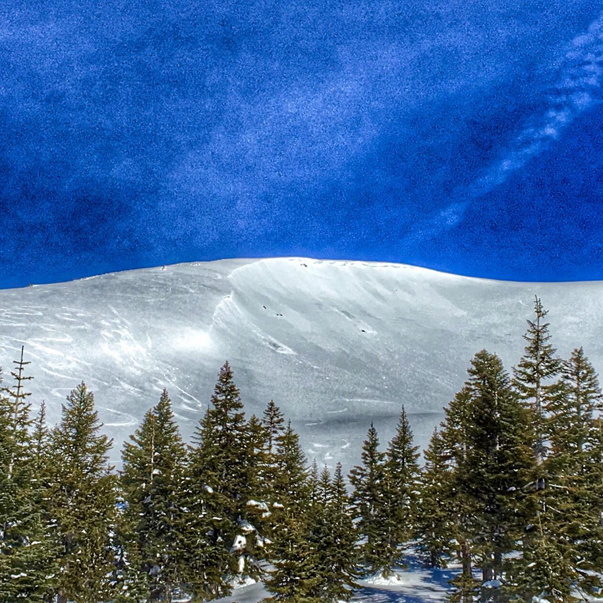
View across Sun Bowl to SE aspect. Note the two small naturally triggered wind slab avalanches with starting zones directly below cornice formations:
_______________________________________________________________________________________________________________________________________________
LOCAL AREA ROAD, NORDIC and SNOWMOBILE PARK STATUS:
The Sand Flat cross country ski trails are in great shape and ready for your cross country skis or snow shoes. These are backcountry trails marked with blue diamonds on trees. Trails are not groomed. Snow shoers, please blaze a parallel trail to cross country skiers staying out of the skin track. These trails can be accessed via the Everett Memorial Highway. Thank you, and enjoy!
The Mt Shasta Nordic Center is open! These beautiful, groomed trails can be accessed via the Ski Park Highway. http://www.mtshastanordic.org
The Pilgrim Creek & Deer Mountain Snowmobile Parks are open! Trails are being groomed currently. Head to our "Education" tab on our website and find the snowmobile section for trail information, grooming status and other sledder resources!
The Castle Lake road is plowed to the lake. The Everett Memorial Highway is plowed to Bunny Flat.
The Five Red Flags of Avalanche Danger any time of year include: 1) Recent/current avalanche activity 2) Whumphing sounds or shooting cracks 3) Recent/current heavy snowfall 4) Strong winds transporting snow 5) Rapid warming or rain on snow.
Weather and Current Conditions
Weather Summary
Good Morning! In Mt Shasta City at 0500, we have a current temperature of 45 F, fifteen degrees warmer than yesterday at this time. Skies are partly to mostly cloudy with calm wind.
On Mt Shasta (South Side) in the last 24 hours...
Old Ski Bowl - 7,600 feet, the current temperature is 35 degrees F. Snow on the ground totals 117 inches with no new snow and 2 inches of settlement. Temperatures have ranged from 31 F to 44 F.
Grey Butte - 8,000 feet, the current temperature is 34 degrees F. Temperatures have ranged from 33 F to 40 F. Winds have been averaging 10-15 mph, with a max gust to 28 mph, west/northwest.
Mt Eddy Range (West side of Interstate-5)...
Castle Lake - 5,600 feet, the current temperature is 39 degrees. Temperatures have ranged from 35 F to 49 F. Snow on the ground totals 66 inches with no new snow and 2 inches of settlement.
Mt Eddy - 6,500 feet, the current temperature is 42 degrees F. Temperatures have ranged from 32 F to 47 F. Snow on the ground measures 84 inches with no new snow and no new settlement. Winds have averaged 2 mph, west/southwest with a max gust of 16 mph, southeast.
Always check the weather before you attempt to climb Mt Shasta. Further, monitor the weather as you climb. Becoming caught on the mountain in any type of weather can compromise life and limb. Be prepared.
| 0600 temperature: | 33 |
| Max. temperature in the last 24 hours: | 44 |
| Average wind direction during the last 24 hours: | West/northwest |
| Average wind speed during the last 24 hours: | 10-15 mi/hr |
| Maximum wind gust in the last 24 hours: | 28 mi/hr |
| New snowfall in the last 24 hours: | 0 inches |
| Total snow depth: | 94 inches |
Two Day Mountain Weather Forecast
Produced in partnership with the Medford NWS
| For 7000 ft to 9000 ft | |||
|---|---|---|---|
|
Thursday (4 a.m. to 10 p.m.) |
Thursday Night (10 p.m. to 4 a.m.) |
Friday (4 a.m. to 10 p.m.) |
|
| Weather | Mostly cloudy. Rain, mainly after 10 am. Windy | Cloudy. Rain before 10 pm, then snow between 10 pm and 4 am, then rain and snow after 4 am. The rain could be heavy at times. Windy | Cloudy. Rain before 4 pm, then rain, possibly mixed with snow showers. The rain could be heavy at times. Windy. |
| Temperature (°F) | 37 | 31 | 40 |
| Wind (mi/hr) | South 15-20 mph | South 10-15 mph | Southwest 15-20 mph |
| Precipitation SWE / Snowfall (in) | / 0 | / 3-7 | / 0-.5 |
| For 9000 ft to 11000 ft | |||
| Thursday | Thursday Night | Friday | |
| Weather | Mostly cloudy. Snow, mainly after 10 am. Windy | Cloudy. Snow and windy. Wind chill values as low as zero. | Cloudy. Snow, which a could be heavy at times. Windy with wind chill values as low as -8 |
| Temperature (°F) | 28 | 25 | 26 |
| Wind (mi/hr) | Southwest 45-50 mph with higher gusts | West 3-5 | West 50-55 mph with higher gusts |
| Precipitation SWE / Snowfall (in) | / 3-5 | / 10-16 | / 14-20 |

