

You are here
Avalanche Advisory for 2016-01-30 07:01:17
- EXPIRED ON January 31, 2016 @ 7:01 amPublished on January 30, 2016 @ 7:01 am
- Issued by Jon Dove - Shasta-Trinity National Forest
Bottom Line
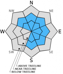
Overall, MODERATE avalanche danger exists near and above treeline on all aspects for newly formed wind and storm slabs. Pockets of CONSIDERABLE danger may exist on leeward S-SE-E-NE-N-NW aspects above treeline. LOW avalanche danger exists below treeline. Some unstable snow could exist on isolated terrain features. Human triggered slides are possible. Evaluate snow and terrain carefully; identify features of concern. Cautious route finding and decision making essential.


Avalanche Problem 1: Wind Slab
-
Character ?

-
Aspect/Elevation ?
-
Likelihood ?CertainVery LikelyLikelyPossible
 Unlikely
 -
Size ?HistoricVery LargeLargeSmall

Moderately strong west/southwest winds associated with yesteday's storm have developed new wind slab formations near and above treeline. Wind slabs small to medium in size will be found in the usual locations just below ridge tops, the tops of chutes and couloirs, depressions, and around rock outcroppings. The strength of the winds may also have transported and deposited snow in non-typical mid-slope locations, as well. Ridge tops will be scoured down to firm, old snow surfaces and cornices have built in size. There is uncertainty concerning wind slab sensitivity to trigger. The most likely place to find and trigger a wind slab today will be on leeward NW-N-NE-E-SE-S aspects, slopes 35 degrees and steeper, in complex terrain, steep chutes, convexities/roll overs, and cross loaded depressions.
Avalanche Problem 2: Storm Slab
-
Character ?

-
Aspect/Elevation ?
-
Likelihood ?CertainVery LikelyLikelyPossible
Unlikely
-
Size ?HistoricVery LargeLargeSmall
Storm slabs have developed at all elevations with yesterday's storm system with the deepest amounts at 7,000 feet and above. 8-10 inches of new snow was observed from Bunny Flat to treeline. The strong west/southwest wind yesterday have limited the amount of storm slab development above treeline. Storm slabs will still be a concern, however, in protected areas near and above treeline.
Forecast Discussion
Clear skies and cold temperatures have followed yesterday's storm activity with a weak trough forecast to pass over the area this afternoon bringing the chance of light rain and snow showers later today. A very cold air mass over the region tonight will bring below freezing temperatures to valley bottoms west of the Cascades. Another weak trough will sweep across Sunday into Monday evening bringing the chance of another round of light precipitation. Snow levels will drop down to around 3,500 feet both tonight and Sunday evening. Winds will begin to calm tonight with light westerly winds at mid-mountain elevations (10,000 ft.) blowing at 10-15 mph, lowering further to 5-10 mph on Sunday. An upper ridge will build over the region early next week, but not before another weak system brings chances of light precipitation Monday night into Tuesday. A break in our persistent wet weather pattern is on the horizon.
THIS SEASON PRECIPITATION for MT SHASTA CITY: Since October 1st (the wet season), we have received 22.46 inches of water, normal is 21.85 inches, putting us at 102% of normal. For the month of January and year of 2016 we've received 12.97 inches of water, normal is 6.64 inches, putting us at 195% of normal .
Recent Observations
Snow levels with yesterday's storm hovered around 6,500 feet with big, wet flakes adding 8-10 inches of new snow to the snowpack. Snow conditions were supportable powder below treeline with wind slab development on leeward S-SE-E-NE-N-NW aspects near and above treeline. Winds were blowing 15-20 mph above treeline along Green Butte Ridge (Broadway) with occasional gusts up to 30 mph. A snow study pit was dug in this area at about 8,200 ft. in elevation, on a 29 degree slope, along the SE edge of Broadway as it rolls over, dropping into Sun Bowl. A look at the snow layers in the upper snowpack revealed that light rain, and temperatures above freezing had made their way up to elevations over 8,000 ft. on Thursday. These conditions formed a rain/melt freeze crust 8 cm thick. New snow and wind from yesterday's storm developed a storm slab 24 cm thick, fist to 4 finger density, that sits on top of the crust. Wet, 1 finger density snow sits below the crust giving the upper snowpack a "right side up" structure. An extended column test was performed resulting in a score of ECTN 16 Q2 at 24 cm deep, failing at the interface with the smooth surfaced rain crust. The cold temperatues and clear, dry conditions may encourage faceting of snow crystals near the rain crust if a steep temperature gradient developes around it. We will monitor this over the coming days.
For today, avalanche danger will remain low below treeline due to the heavy, wet snow and relatively warmer temperatures associated with yesterday's storm. Near and above treeline slopes on wind loaded, leeward S-SE-E-NE-N-NW aspects will be the most suspect for wind slab and storm slab instabilities. Slopes 35 degrees and steeper just below ridge tops and cornices, the tops of chutes and couloirs, mid-slope depressions, extreme terrain, and rock outcroppings are the places that one would be the most likely to trigger an avalanche today. For those traveling in the backcountry, be careful with your evaluation of the snowpack and terrain as you make your way up. Identify features of concern, and avoid them. Good visibility will lure folks above treeline today where snow instabilities will be the most present. Cautious route finding and conservative decision making will be essential.
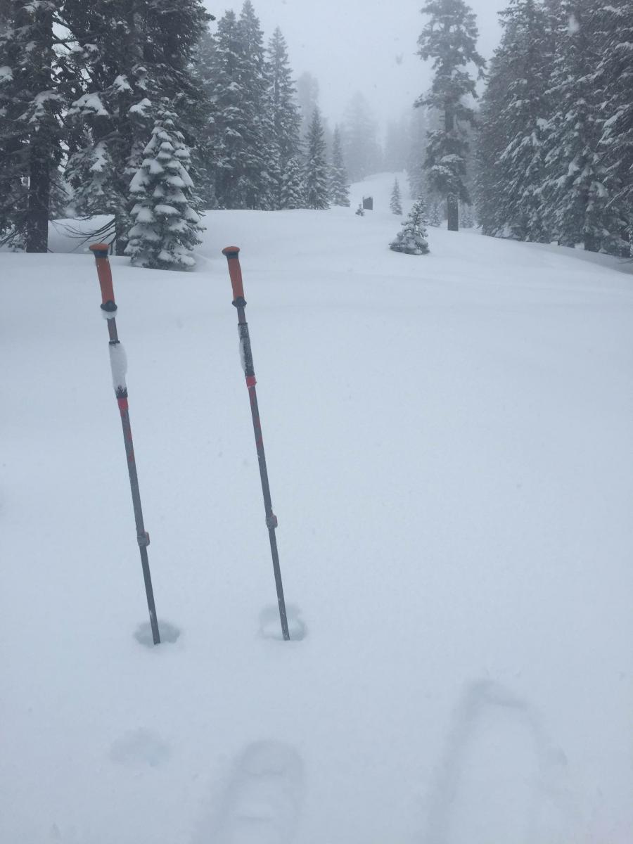
Wet and heavy new snow below treeline on Green Butte Ridge-Photo: Shane Rathbun
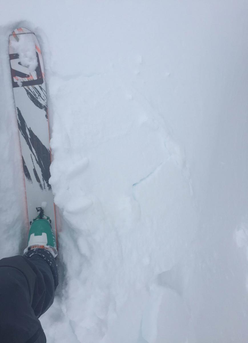
Cracks indicating wind slab formation along wind loaded SE aspect of Sun Bowl, edge of Green Butte Ridge-photo: Shane Rathbun
_______________________________________________________________________________________________________________________________________________
LOCAL AREA ROAD, NORDIC and SNOWMOBILE PARK STATUS:
The Sand Flat cross country ski trails are in great shape and ready for your cross country skis or snow shoes. These are backcountry trails marked with blue diamonds on trees. Trails are not groomed. Snow shoers, please blaze a parallel trail to cross country skiers staying out of the skin track. These trails can be accessed via the Everett Memorial Highway. Thank you, and enjoy!
The Mt Shasta Nordic Center is open! These beautiful, groomed trails can be accessed via the Ski Park Highway. http://www.mtshastanordic.org
The Pilgrim Creek & Deer Mountain Snowmobile Parks are open! Trails are being groomed currently. Head to our "Education" tab on our website and find the snowmobile section for trail information, grooming status and other sledder resources!
The Castle Lake road is plowed to the lake. The Everett Memorial Highway is plowed to Bunny Flat.
The Five Red Flags of Avalanche Danger any time of year include: 1) Recent/current avalanche activity 2) Whumphing sounds or shooting cracks 3) Recent/current heavy snowfall 4) Strong winds transporting snow 5) Rapid warming or rain on snow.
Weather and Current Conditions
Weather Summary
Good Morning! In Mt Shasta City at 0500, we have a current temperature of 33 F, ten degrees cooler than yesterday at this time! Skies are clear with calm winds.
On Mt Shasta (South Side) in the last 24 hours...
Old Ski Bowl - 7,600 feet, the current temperature is 18 degrees F. Snow on the ground totals 126 inches with 8 inches new snow and 1 inch of settlement. Temperatures have ranged from 25 F to 35 F.
Grey Butte - 8,000 feet, the current temperature is 15 degrees F. Temperatures have ranged from 15 F to 29 F. Winds have been averaging 5-10 mph, with a max gust to 21 mph, northwest.
Mt Eddy Range (West side of Interstate-5)...
Castle Lake - 5,600 feet, the current temperature is 24 degrees. Temperatures have ranged from 24 F to 41 F. Snow on the ground totals 64 inches with no new snow and 1 inch of settlement.
Mt Eddy - 6,500 feet, the current temperature is 21 degrees F. Temperatures have ranged from 21 F to 35 F. Snow on the ground measures 85 inches with 3 inches of new snow and no settlement. Winds have averaged 2 mph, southerly in direction with a max gust of 14 mph, southeast.
Always check the weather before you attempt to climb Mt Shasta. Further, monitor the weather as you climb. Becoming caught on the mountain in any type of weather can compromise life and limb. Be prepared.
| 0600 temperature: | 22 |
| Max. temperature in the last 24 hours: | 34 |
| Average wind direction during the last 24 hours: | Westerly |
| Average wind speed during the last 24 hours: | 5-10 mi/hr |
| Maximum wind gust in the last 24 hours: | 21 mi/hr |
| New snowfall in the last 24 hours: | 8 inches |
| Total snow depth: | 102 inches |
Two Day Mountain Weather Forecast
Produced in partnership with the Medford NWS
| For 7000 ft to 9000 ft | |||
|---|---|---|---|
|
Saturday (4 a.m. to 10 p.m.) |
Saturday Night (10 p.m. to 4 a.m.) |
Sunday (4 a.m. to 10 p.m.) |
|
| Weather | Partly sunny. Snow showers likely mainly after 10 am. Chance of precipitation 70%. | Mostly cloudy with a 40% chance of snow showers. | Partly sunny. A 40% chance of snow showers, mainly before 4 pm. |
| Temperature (°F) | 28 | 16 | 26 |
| Wind (mi/hr) | West 5-10 mph | West 5-10 mph | Northeast 5-10 mph |
| Precipitation SWE / Snowfall (in) | / 1-2 | / 0-.5 | / 0-.5 |
| For 9000 ft to 11000 ft | |||
| Saturday | Saturday Night | Sunday | |
| Weather | Partly sunny and cold. Snow showers likely, mainly after 10 am. Chance of precipitation 70%. Windy with wind chill values as low as -22. | Mostly cloudy with a 40% chance of snow showers. Wind chill values as low as -16. | Partly sunny and cold with a 50% chance of snow showers. Wind chill values as low as -18. |
| Temperature (°F) | 5 | 5 | 2 |
| Wind (mi/hr) | West 15-20 mph | West 2-4 | Northwest 5-10 mph |
| Precipitation SWE / Snowfall (in) | / 2-4 | / 0-1 | / 0-.5 |

