

You are here
Avalanche Advisory for 2016-01-31 06:59:05
- EXPIRED ON February 3, 2016 @ 6:59 amPublished on January 31, 2016 @ 6:59 am
- Issued by Jon Dove - Shasta-Trinity National Forest
Bottom Line
-DUE TO SHORT STAFFING, TODAY'S ADVISORY WILL EXPIRE AT 7:00 AM ON WEDNESDAY 2/3/2016-
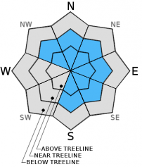
Overall, MODERATE avalanche danger exists near and above treeline on NW-N-NE-E-SE-S aspects for newly formed wind slabs. Elevations above 9,000 ft. may be less likely to trigger wind slabs due to the lack of rain crust as a bed surface. LOW avalanche danger exists below treeline, all aspects . Human triggered slides are possible. Evaluate snow and terrain carefully; identify features of concern.


Avalanche Problem 1: Wind Slab
-
Character ?

-
Aspect/Elevation ?
-
Likelihood ?CertainVery LikelyLikelyPossible
 Unlikely
 -
Size ?HistoricVery LargeLargeSmall

Moderately strong west/southwest winds associated with Friday's storm have developed new wind slab formations near and above treeline. Wind slabs small to medium in size will be found in the usual locations just below ridge tops, the tops of chutes and couloirs, depressions, and around rock outcroppings. The strength of the winds may also have transported and deposited snow in non-typical mid-slope locations, as well. Ridge tops will be scoured down to firm, old snow surfaces and cornices have built in size. There is uncertainty concerning wind slab sensitivity to trigger. Stability tests performed yesterday on the crown of an wind slab avalanche that occurred Friday afternoon to evening in Sun Bowl had no results indicating that wind slabs may be stubborn to trigger. If just the right trigger point is stumbled upon, however, the resulting slide could be medium is size and easily bury, injure, or even kill a person. The most likely place to find and trigger a wind slab today will be on leeward NW-N-NE-E-SE-S aspects, 9,000 ft. and below, on slopes 35 degrees and steeper, in complex terrain, steep chutes, convexities/roll overs, and cross loaded depressions. The wind slab problem will become less of an issue into the coming week with no significant precipitation event in our near future.
Avalanche Problem 2: Storm Slab
-
Character ?

-
Aspect/Elevation ?
-
Likelihood ?CertainVery LikelyLikelyPossible
Unlikely
-
Size ?HistoricVery LargeLargeSmall
Storm slabs have developed at all elevations with Friday's storm system with the deepest amounts at 7,000 feet and above. 8-10 inches of new snow was observed from Bunny Flat to treeline. The strong west/southwest wind yesterday have limited the amount of storm slab development above treeline. Storm slabs will become less of a worry over the coming days as there is no significant precipitation event in the near future.
Forecast Discussion
It looks like we are phasing out of our consistent wet weather pattern for a more dry one over the coming week. A weak upper level trough and a cold air mass aloft will continue a threat of scattered light showers to the area today. However, looking at the Quantitative Precipitation Forecast (QPF) models for precipitation amounts, mid-day today is the only time we might receive precipitation with a whopping total of 0.01 inches of water. There is no measurable amount of precipitation again until early Tuesday with a grand total of 0.03 inches. The remainder of the week looks to be bone dry. It is still a ways out, but next weekend looks to be mostly sunny with warming temperatures. The beginning of the week will remain cold both Monday and Tuesday, with the gradual warming trend starting on Wednesday. Winds will be moderate (20-40 mph with higher gusts) at mid-mountain levels (10,000 ft.) coming out of a northerly direction for Monday and Tuesday, as well.
THIS SEASON PRECIPITATION for MT SHASTA CITY: Since October 1st (the wet season), we have received 22.46 inches of water, normal is 22.06 inches, putting us at 101% of normal. For the month of January and year of 2016 we've received 12.97 inches of water, normal is 6.85 inches, putting us at 189% of normal .
Recent Observations
-DUE TO LOW STAFFING, THIS ADVISORY WILL EXPIRE AT 7:00 AM ON WEDNESDAY, FEBRUARY 3rd-
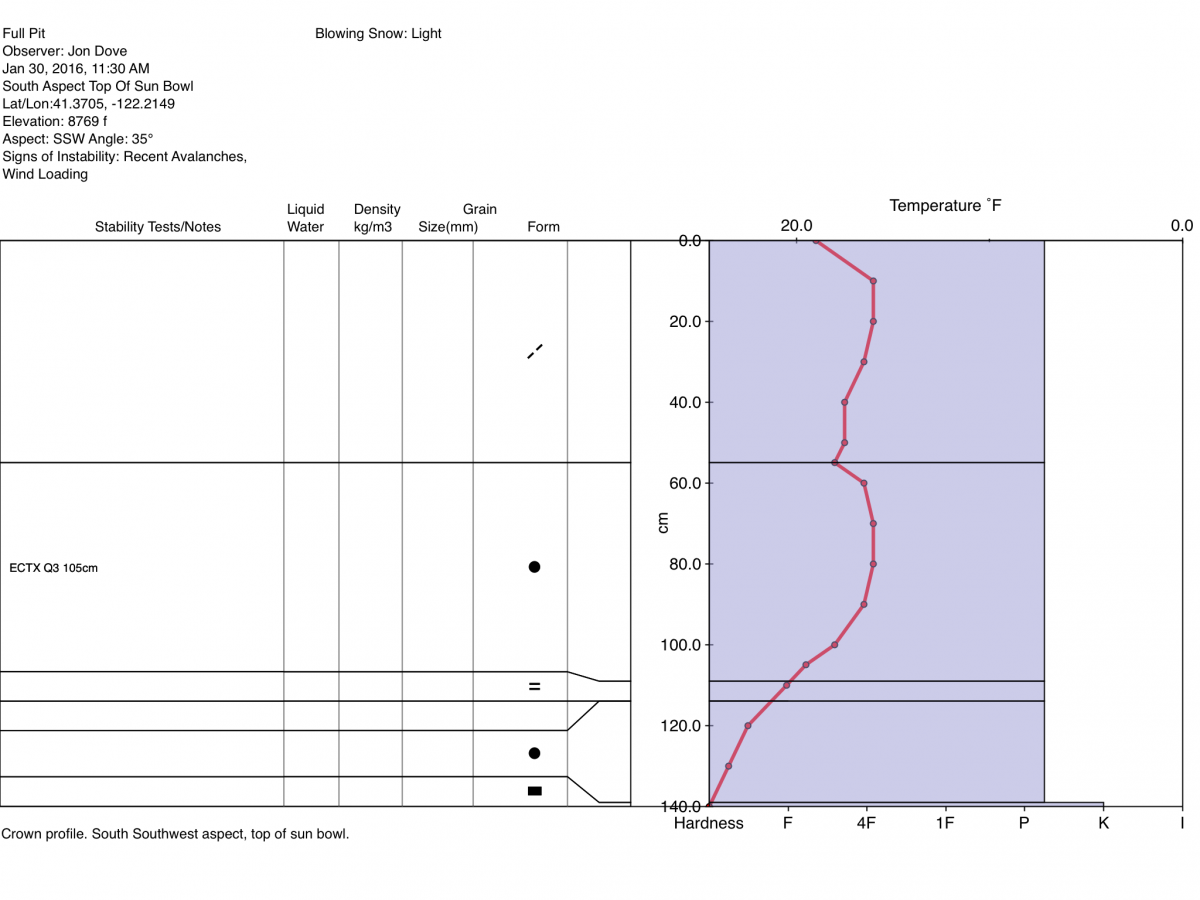
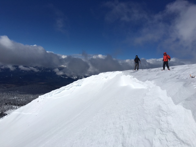
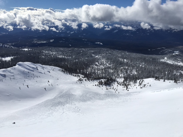
People that tried to take advantage of yesterday's blue skies and venture above treeline were greeted with a mix bag of conditions. Some aspects were wind buffed firm snow. Ridge tops were scoured with the Broadway portion of Green Butte Ridge a mix of frozen rain crust and wind sculpted snow pillows from Friday's storm. Sun Bowl had a dozy of an avalanche that occurred sometime Friday afternoon to evening. It was given an avalanche type of HS-N-D2-R4 (Hard Slab, Naturally released with a destructive potential-D2- to bury, injure, or kill a person that was large relative to the path-R4). The crown of the avalanche varied in height from 55 cm to over 110 cm and spread almost the whole width of the bowl, carving some cornice formations from the ridge top, as well. The slide was a hard, wind slab avalanche of wind deposited snow that built up during Friday's storm. The cohesive slab slid on a firm and smooth bed surface of 5-8 cm thick rain crust that formed on Thursday. Once again, snow does not like rapid change, and with the strong westerly winds quickly transported the 20-25 cm of new snow to form a thick and heavy slab. The nature of the rain crust provided an ideal, slick bed surface to slide on.
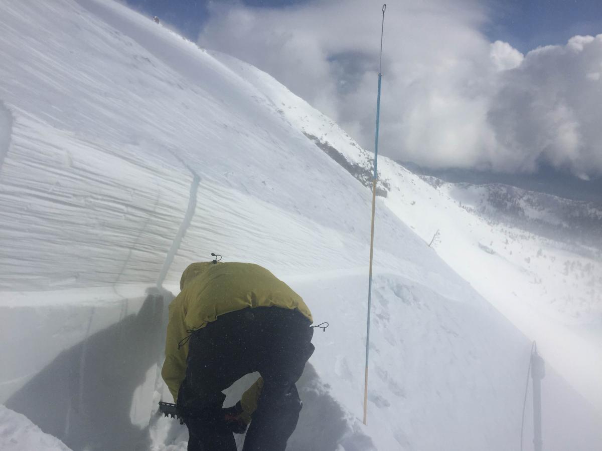
Upon viewing the crown from Bunny Flat yesterday morning, I decided to go up and do a profile of the crown and perform some stability tests on it. Snow had drifted in and obscured the bottom of the crown so I dug down to the suspected weak interface with the rain crust approximately 105-110 cm deep. Only the top 55 cm of the crown was visible. Two extended column tests were performed, each resulting in ECTX. After the second ECT was completed I was curious what an unofficial, non-scientific shovel shear would show. I barely had to pull on the shovel blade when it was inserted behind the column to the interface with the rain crust to fail. That sparked my curiosity more so I isolated a 30cm by 100 cm column and performed a propagation saw test (PST). I was able to get the saw blade to 32 cm before any reaction was witnessed. The test did not reveal full propagation along the interface of the wind slab and rain crust with the observable result being a slab fracture.
For today, avalanche danger will remain low below treeline as any storm slabs have bonded well with underlying snow. Near and above treeline slopes on wind loaded, leeward S-SE-E-NE-N-NW aspects below 9,000 ft. will be the most suspect for wind slab instabilities again today. Slopes 35 degrees and steeper just below ridge tops and cornices, the tops of chutes and couloirs, mid-slope depressions, extreme terrain, and rock outcroppings are the places that one would be the most likely to to find and trigger a wind slab avalanche today. For Monday and Tuesday, wind slabs will have the opportunity to continue to bond with underlying snow, and storm slabs will settled as well. The is not a significant amount of snow or rain in the forecast that would increase wind or storm slab avalanche problems. For those traveling in the backcountry, be careful with your evaluation of the snowpack and terrain as you make your way up. Identify features of concern, and avoid them. Good visibility will lure folks above treeline again today where snow instabilities will be the most present. Cautious route finding and conservative decision making will be essential.
Crown of Sun Bowl avalanche-photo: Jon Dove
Avalanche debris collected in the run out zone at the bottom of Sun Bowl-photo: Jon Dove
Jon Dove preparing a stability test on an area of the crown-photo: Shane Rathbun
_______________________________________________________________________________________________________________________________________________
LOCAL AREA ROAD, NORDIC and SNOWMOBILE PARK STATUS:
The Sand Flat cross country ski trails are in great shape and ready for your cross country skis or snow shoes. These are backcountry trails marked with blue diamonds on trees. Trails are not groomed. Snow shoers, please blaze a parallel trail to cross country skiers staying out of the skin track. These trails can be accessed via the Everett Memorial Highway. Thank you, and enjoy!
The Mt Shasta Nordic Center is open! These beautiful, groomed trails can be accessed via the Ski Park Highway. http://www.mtshastanordic.org
The Pilgrim Creek & Deer Mountain Snowmobile Parks are open! Trails are being groomed currently. Head to our "Education" tab on our website and find the snowmobile section for trail information, grooming status and other sledder resources!
The Castle Lake road is plowed to the lake. The Everett Memorial Highway is plowed to Bunny Flat.
The Five Red Flags of Avalanche Danger any time of year include: 1) Recent/current avalanche activity 2) Whumphing sounds or shooting cracks 3) Recent/current heavy snowfall 4) Strong winds transporting snow 5) Rapid warming or rain on snow.
Weather and Current Conditions
Weather Summary
Good Morning! In Mt Shasta City at 0500, we have a current temperature of 30 F, thress degrees cooler than yesterday at this time. Skies are overcast with calm winds.
On Mt Shasta (South Side) in the last 24 hours...
Old Ski Bowl - 7,600 feet, the current temperature is 11 degrees F. Snow on the ground totals 124 inches with no new snow and 2 inches of settlement. Temperatures have ranged from 25 F to 35 F.
Grey Butte - 8,000 feet, the current temperature is 11 degrees F. Temperatures have ranged from 11 F to 22 F. Winds have been averaging 5-10 mph, with a max gust to 14 mph, northwest.
Mt Eddy Range (West side of Interstate-5)...
Castle Lake - 5,600 feet, the current temperature is 21 degrees. Temperatures have ranged from 20 F to 31 F. Snow on the ground totals 63 inches with no new snow and 1 inch of settlement.
Mt Eddy - 6,500 feet, the current temperature is 16 degrees F. Temperatures have ranged from 11 F to 25 F. Snow on the ground measures 81 inches with no new snow and 4 inches of settlement. Winds have averaged 2 mph, southerly in direction with a max gust of 12 mph, southeast.
Always check the weather before you attempt to climb Mt Shasta. Further, monitor the weather as you climb. Becoming caught on the mountain in any type of weather can compromise life and limb. Be prepared.
| 0600 temperature: | 9 |
| Max. temperature in the last 24 hours: | 26 |
| Average wind direction during the last 24 hours: | Variable |
| Average wind speed during the last 24 hours: | 5-10 mi/hr |
| Maximum wind gust in the last 24 hours: | 14 mi/hr |
| New snowfall in the last 24 hours: | 0 inches |
| Total snow depth: | 100 inches |
Two Day Mountain Weather Forecast
Produced in partnership with the Medford NWS
| For 7000 ft to 9000 ft | |||
|---|---|---|---|
|
Sunday (4 a.m. to 10 p.m.) |
Sunday Night (10 p.m. to 4 a.m.) |
Monday (4 a.m. to 10 p.m.) |
|
| Weather | Partly Sunny with a 20% chance of snow showers | Mostly cloudy with a 20% chance of snow showers. Wind chill values as low as -3. | Mostly cloudy, then gradually becoming sunny. A 20% chance of showers before 10 am. Wind chill values as low as zero. |
| Temperature (°F) | 25 | 14 | 25 |
| Wind (mi/hr) | North 5-10 mph | Northwest 10-15 mph | Northwest 10-15 mph |
| Precipitation SWE / Snowfall (in) | / 0 | / 0 | / 0 |
| For 9000 ft to 11000 ft | |||
| Sunday | Sunday Night | Monday | |
| Weather | Partly sunny and cold. A 30% chance of snow showers, mainly after 10 am. Wind chill values as low as -22 | Mostly cloudy with a 20% chance of snow showers. Windy with wind chill values as low as -25. | Mostly cloudy, then gradually becoming sunny and cold. A 20% chance of snow showers before 10 am. Windy with wind chill values as low as -24. |
| Temperature (°F) | 2 | 2 | 9 |
| Wind (mi/hr) | North 10-15 mph gust to 20+ mph | North 0-.5 | North 25-30 mph with gusts to 45 mph |
| Precipitation SWE / Snowfall (in) | / 0-.5 | / 0 | / 0 |

