

You are here
Avalanche Advisory for 2016-02-03 07:04:05
- EXPIRED ON February 4, 2016 @ 7:04 amPublished on February 3, 2016 @ 7:04 am
- Issued by Jon Dove - Shasta-Trinity National Forest
Bottom Line
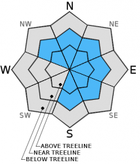
Overall, LOW avalanche danger exists on all elevations, all aspects. Pockets of MODERATE avalanche danger may exist on leeward NW-N-NE-E-SE-S aspects, near and above treeline for lingering wind slab instabilities. There is high uncertainty to wind slab sensitivity to any trigger. Avalanche danger will increase for both wind and storm slabs with today's storm. Some unstable snow may be found on isolated terrain features. Evaluate snow and terrain carefully. Normal caution is advised.


Avalanche Problem 1: Wind Slab
-
Character ?

-
Aspect/Elevation ?
-
Likelihood ?CertainVery LikelyLikelyPossible
 Unlikely
 -
Size ?HistoricVery LargeLargeSmall

Wind slabs small to medium in size may still be found in isolated locations above treeline. There has not been any potential for new wind slab formation since the weekend, however, today's storm will bring a significant enough amount of new snow that will be easily transported by moderate southwest/west winds to form new wind slabs. Ridge tops are scoured down to firm, old snow surfaces and cornices will begin to build in size. There is uncertainty concerning any current wind slab's sensitivity to trigger. If just the right trigger point is stumbled upon the resulting slide could be small to medium is size and easily bury, injure, or even kill a person. The most likely place to find and trigger a wind slab today will be near and above treeline on leeward NW-N-NE-E-SE-S aspects on slopes 37 degrees and steeper, in complex terrain, steep chutes, convexities/roll overs, and cross loaded depressions. Look for snow surface clues, blowing snow, cornice formations, wind pillows, or other obviously wind sculpted formations to help identify any suspect slopes.
Avalanche Problem 2: Storm Slab
-
Character ?

-
Aspect/Elevation ?
-
Likelihood ?CertainVery LikelyLikelyPossible
Unlikely
-
Size ?HistoricVery LargeLargeSmall
Currently there is little concern for storm slab instabilities as there has only been around an inch of new snow accumulated over the past 48 hours. This may change today with the approaching frontal system that is forecast to bring 3-5 inches of new snow. Avalanche danger for storm slabs will surely increase on all aspects and elevations if we receive the the predicted amounts. Storm slab problems typically last between a few hours and a few days after being deposited. Slopes 35 degrees and steeper will be the most prone to new storm slab instabilities.
Forecast Discussion
High clouds have developed over the area in advance of the approaching front and short wave trough. This brief system will gradually move into the region today bringing the threat of snow to 3,000-3,500 feet in the morning, then rising to 4,000-4,500 ft by the afternoon. There is a slight chance we may see a few flakes here in Mount Shasta City. This storm is forecast to drop 0.22 inches of water over our area, which will translate into 3-5 inches of new snow. A "winter weather advisory" is in effect for the area from 10 am today until 10 pm tonight. Winds will be moderate with a primarily southwest direction with speeds above treeline at mid-mountain (10,000 ft.) levels approaching 40 mph with occasional higher gusts. Winds near treeline will be slightly lower at 20-25 mph, also in a southwesterly direction. By Thursday winds will begin to calm, dropping to 10-20 mph and shifting to a west/northwest direction. An upper level ridge will build back into the area bringing dry weather on Thursday. Another short wave trough and frontal system will move toward the Mt. Shasta area early Friday bringing another chance of some light precipitation for the start of the weekend.
THIS SEASON PRECIPITATION for MT SHASTA CITY: Since October 1st (the wet season), we have received 22.56 inches of water, normal is 22.75 inches, putting us at 99% of normal. For the month of February we've received 0.07 inches of water, normal is 0.48 inches, putting us at 14% of normal, and for the year of 2016 we've received 13.07 inches of water, normal is 7.54 inches, putting us at 173% of normal .
Recent Observations
Reports from the field are limited to observations made on Monday, 2/1/2016 from a ski tour up Green Butte Ridge. Colder temperatures helped to maintain soft snow conditions near and below treeline with significantly wind affect snow above treeline. A quick storm that passed through Monday night deposited around an inch of snow all the way down to Mt. Shasta City. This low amount was not enough to have an impact on avalanche conditions which have dropped to an overall danger level of LOW for all elevations and aspects. There is some uncertainty as to any lingering danger from wind slabs on leeward NW-N-NE-E-SE-S aspects above treeline. There may be pockets of unstable wind slab snow formations on isolated terrain features on slopes 37 degrees and steeper, in typical starting zones below ridge tops, at the tops of chutes and couloirs, the tops of roll overs and convexities, rock outcroppings in extreme terrain, and any mid-slope depressions.
For today, evaluate snow and terrain carefully above treeline for any signs of wind loading on leeward S-SE-E-NE-N-NW aspects. Isolated terrain, on open slopes 37 degrees and steeper are the places that one would be the most likely to to find and trigger a wind slab avalanche today. There may be new snow amounts with today's storm that are significant enough to increase the avalanche danger for both wind and storm slab avalanche problems. For those traveling in the backcountry today normal caution is advised. Don't let complacency cloud your observation of snowpack and terrain as you make your way up in elevation. Maintain good group communication, stay spaced out when crossing known avalanche paths, identify features of concern, and avoid them. Visibility above treeline will deteriorate as the day progresses limiting travel opportunities at higher elevations.
_______________________________________________________________________________________________________________________________________________
LOCAL AREA ROAD, NORDIC and SNOWMOBILE PARK STATUS:
The Sand Flat cross country ski trails are in great shape and ready for your cross country skis or snow shoes. These are backcountry trails marked with blue diamonds on trees. Trails are not groomed. Snow shoers, please blaze a parallel trail to cross country skiers staying out of the skin track. These trails can be accessed via the Everett Memorial Highway. Thank you, and enjoy!
The Mt Shasta Nordic Center is open! These beautiful, groomed trails can be accessed via the Ski Park Highway. http://www.mtshastanordic.org
The Pilgrim Creek & Deer Mountain Snowmobile Parks are open! Trails are being groomed currently. Head to our "Education" tab on our website and find the snowmobile section for trail information, grooming status and other sledder resources!
The Castle Lake road is plowed to the lake. The Everett Memorial Highway is plowed to Bunny Flat.
The Five Red Flags of Avalanche Danger any time of year include: 1) Recent/current avalanche activity 2) Whumphing sounds or shooting cracks 3) Recent/current heavy snowfall 4) Strong winds transporting snow 5) Rapid warming or rain on snow.
Weather and Current Conditions
Weather Summary
Good Morning! In Mt Shasta City at 0500, we have a current temperature of 28 F, two degrees warmer than yesterday at this time. Skies are overcast with calm winds.
On Mt Shasta (South Side) in the last 24 hours...
Old Ski Bowl - 7,600 feet, the current temperature is 15 degrees F. Snow on the ground totals 122 inches with 1 inch of new snow and 2 inches of settlement. Temperatures have ranged from 25 F to 35 F.
Grey Butte - 8,000 feet, the current temperature is 16 degrees F. Temperatures have ranged from 12 F to 20 F. Winds have been averaging 10 mph, with a max gust to 21 mph, west/northwest.
Mt Eddy Range (West side of Interstate-5)...
Castle Lake - 5,600 feet, the current temperature is 21 degrees. Temperatures have ranged from 19 F to 32 F. Snow on the ground totals 64 inches with 2 inches of new snow and 1 inch of settlement.
Mt Eddy - 6,500 feet, the current temperature is 23 degrees F. Temperatures have ranged from 13 F to 23 F. Snow on the ground measures 83 inches with no new snow and 1 inch of settlement. Winds have averaged 3 mph, variable in direction with a max gust of 8 mph, east/southeast.
Always check the weather before you attempt to climb Mt Shasta. Further, monitor the weather as you climb. Becoming caught on the mountain in any type of weather can compromise life and limb. Be prepared.
| 0600 temperature: | 18 |
| Max. temperature in the last 24 hours: | 25 |
| Average wind direction during the last 24 hours: | Westerly |
| Average wind speed during the last 24 hours: | 10 mi/hr |
| Maximum wind gust in the last 24 hours: | 21 mi/hr |
| New snowfall in the last 24 hours: | 1 inches |
| Total snow depth: | 99 inches |
Two Day Mountain Weather Forecast
Produced in partnership with the Medford NWS
| For 7000 ft to 9000 ft | |||
|---|---|---|---|
|
Wednesday (4 a.m. to 10 p.m.) |
Wednesday Night (10 p.m. to 4 a.m.) |
Thursday (4 a.m. to 10 p.m.) |
|
| Weather | Cloudy. Snow, mainly after 10 am. | Mostly cloudy. Snow showers, mainly before 10 pm. | Partly sunny |
| Temperature (°F) | 28 | 20 | 33 |
| Wind (mi/hr) | South 20-25 mph | Southwest 15-20 mph | West 5-10 mph |
| Precipitation SWE / Snowfall (in) | / 3-5 | / 0-1 | / 0 |
| For 9000 ft to 11000 ft | |||
| Wednesday | Wednesday Night | Thursday | |
| Weather | Cloudy. Snow, mainly after 11 am. Windy with wind chill values as low as -7 | Mostly cloudy. Snow showers mainly before 11 pm. Windy with wind chill values as low as -11. | Partly sunny. Windy with wind chill values as low as -10. |
| Temperature (°F) | 20 | 14 | 16 |
| Wind (mi/hr) | Southwest 35-40 mph with gusts to 50+ mph | West 2-4 | Northwest 20-25 mph with gusts to 40 mph. |
| Precipitation SWE / Snowfall (in) | / 2-4 | / 1-2 | / 0 |

