

You are here
Avalanche Advisory for 2016-02-04 07:00:33
- EXPIRED ON February 5, 2016 @ 7:00 amPublished on February 4, 2016 @ 7:00 am
- Issued by Jon Dove - Shasta-Trinity National Forest
Bottom Line
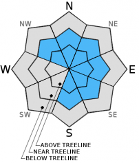
Overall, LOW avalanche danger exists at all elevations, all aspects. Pockets of MODERATE avalanche danger remain near and above treeline for newly formed wind slabs on S-SE-E-NE-N aspects with possible cross loading on NW aspects. There is uncertainty to wind slab sensitivity to any trigger. Some unstable snow may be found on isolated terrain features, slopes 37 degrees and steeper. Evaluate snow and terrain carefully. Normal caution is advised.


Avalanche Problem 1: Wind Slab
-
Character ?

-
Aspect/Elevation ?
-
Likelihood ?CertainVery LikelyLikelyPossible
 Unlikely
 -
Size ?HistoricVery LargeLargeSmall

Newly formed wind slabs of small to possibly medium in size may be found on leeward S-SE-E-NE-N aspects near and above treeline with some cross loading possible on NW aspects. Ridge tops are scoured down to firm, old snow surfaces and cornices have formed or built in size. There is uncertainty concerning any current wind slab's sensitivity to trigger. If just the right trigger point is stumbled upon the resulting slide could be small to medium is size and easily bury, injure, or even kill a person. The most likely place to find and trigger a wind slab today will be near and above treeline on leeward NW-N-NE-E-SE-S aspects on slopes 37 degrees and steeper, in complex terrain, steep chutes, convexities/roll overs, and cross loaded depressions. Look for snow surface clues, blowing snow, cornice formations, wind pillows, or other obviously wind sculpted formations to help identify any suspect slopes.
Avalanche Problem 2: Storm Slab
-
Character ?

-
Aspect/Elevation ?
-
Likelihood ?CertainVery LikelyLikelyPossible
Unlikely
-
Size ?HistoricVery LargeLargeSmall
Storm slabs did not develop yesterday as thick as they were expected to based on the new snow amounts predicted by yesterday's weather models. New snow depths of 3-5 inches with some slightly deeper pockets were observed. This new snow is sitting on top of a supportable crust layer that developed on Monday. The potential for any instabilities associated with the new storm snow layer will decrease with sun exposure and warming temperatures over the next 48 hours. That being said, there is 3-5 inches of soft snow, with some isolated deeper pockets, laying on top of a firm bed surface. The storm slab avalanche problem will exist today on all aspects, all elevations. The likely hood of finding storm slabs near and above treeline is less due to impacts of wind transport on open, exposed slopes. Storm slab problems typically last between a few hours and a few days after being deposited. Open slopes, 37 degrees and steeper near and below treeline will be the most prone to any remaining storm slab instabilities.
Forecast Discussion
Yesterday's storm did not produce as much precipitation as forecast. We received a mere 0.08-0.06 inches of water versus the 0.22 inches models predicted to fall. Overcast skies early this morning will give way to pockets of sunshine as the day progresses. This will be the result of the short wave trough lifting toward the northeast, and a upper level ridge building into the area from the west. The ridge will remain over the area tonight keeping things dry until mid-day Friday when another weak shortwave trough approaches the region. The trough and associated cold front will bring a slight chance of precipitation mid to late afternoon on Friday, however, the amounts forecast for total just 0.02 inches resulting in only trace amounts of snow. The outlook beyond Friday for our area holds lots of sunshine and mild temperatures. We will likely be entering into a "melt/freeze" cycle and may be seeing corn snow conditions begin to take form at elevations up to 10,000 ft. by Wednesday of next week.
THIS SEASON PRECIPITATION for MT SHASTA CITY: Since October 1st (the wet season), we have received 22.62 inches of water, normal is 23.00 inches, putting us at 98% of normal. For the month of February we've received 0.13 inches of water, normal is 0.73 inches, putting us at 17% of normal, and for the year of 2016 we've received 13.13 inches of water, normal is 7.79 inches, putting us at 168% of normal .
Recent Observations
Temperatures over the past few days have remained cold enough to preserve decent snow conditions for skiing and riding, mainly below treeline. Wind and some sun exposure, however, managed to form a thick crust layer on Monday. That crust layer has been buried by 3-5 inches of new snow resulting from light precipitation events on Tuesday, and then again on Wednesday. A tour yesterday up toward the bottom of Sun Bowl on Mt. Shasta revealed "dust on crust" conditions from near treeline down. Poor visibility prevented getting observations at higher elevations. The ski descent from treeline actually improved the further one dropped through the trees with better snow conditions in more protected areas. An extended column test performed on a SE aspect at approximately 8,000 ft. on a 30 degree slope resulted in a score of ECTN 25 Q3 approximately 23 cm deep. The thick crust from Monday took a moderate to strong amount of effort to break through compressing the softer, less dense snow underneath. Warming temperatures over the next couple of days will aid in consolidating the soft snow that lays between the thick crust that formed Thursday of last week, and Monday's supportable crust layer.
That leaves us with the concern for wind slabs that developed from the 3-5 inches of snow available for wind transport on top of Monday's crust. The effort to find new wind slabs was made difficult by the aforementioned poor visibility. Wind had definitely had an impact on snow in more exposed locations, along ridge tops and on open slopes. 3-5 inches of snow can easily turn into wind slabs up to 12+ inches in depth, small to medium in size, that could easily entrain enough snow to bury a person. The question remains as to how well wind slabs are bonding with the crust layer.
For today, evaluate snow and terrain carefully above treeline for any signs of wind loading on leeward S-SE-E-NE-N-NW aspects. Decent visibility above treeline will lure folks to higher elevations onto open slopes requiring more objective decision making. Isolated terrain, on open slopes 37 degrees and steeper, the tops of chutes and couloirs, near rock outcroppings, depressions, and along roll overs/convexities will be the places that one would be the most likely to find and potentially trigger a wind slab avalanche. For those traveling in the backcountry today normal caution is advised. Don't let complacency cloud your observation of snowpack and terrain as you make your way up in elevation. Maintain good group communication, stay spaced out when crossing known avalanche paths or suspect slopes, identify features of concern, and avoid them.
_______________________________________________________________________________________________________________________________________________
LOCAL AREA ROAD, NORDIC and SNOWMOBILE PARK STATUS:
The Sand Flat cross country ski trails are in great shape and ready for your cross country skis or snow shoes. These are backcountry trails marked with blue diamonds on trees. Trails are not groomed. Snow shoers, please blaze a parallel trail to cross country skiers staying out of the skin track. These trails can be accessed via the Everett Memorial Highway. Thank you, and enjoy!
The Mt Shasta Nordic Center is open! These beautiful, groomed trails can be accessed via the Ski Park Highway. http://www.mtshastanordic.org
The Pilgrim Creek & Deer Mountain Snowmobile Parks are open! Trails are being groomed currently. Head to our "Education" tab on our website and find the snowmobile section for trail information, grooming status and other sledder resources!
The Castle Lake road is plowed to the lake. The Everett Memorial Highway is plowed to Bunny Flat.
The Five Red Flags of Avalanche Danger any time of year include: 1) Recent/current avalanche activity 2) Whumphing sounds or shooting cracks 3) Recent/current heavy snowfall 4) Strong winds transporting snow 5) Rapid warming or rain on snow.
Weather and Current Conditions
Weather Summary
Good Morning! In Mt Shasta City at 0500, we have a current temperature of 30 F, two degrees warmer than yesterday at this time. Skies are overcast with calm winds.
On Mt Shasta (South Side) in the last 24 hours...
Old Ski Bowl - 7,600 feet, the current temperature is 17 degrees F. Snow on the ground totals 122 inches with 1 inch of new snow and 1 inch of settlement. Temperatures have ranged from 15 F to 24 F.
Grey Butte - 8,000 feet, the current temperature is 17 degrees F. Temperatures have ranged from 16 F to 21 F. Winds have been averaging 5-10 mph, with a max gust to 14 mph, west/northwest.
Mt Eddy Range (West side of Interstate-5)...
Castle Lake - 5,600 feet, the current temperature is 22 degrees. Temperatures have ranged from 22 F to 28 F. Snow on the ground totals 66 inches with 2 inches of new snow and no settlement.
Mt Eddy - 6,500 feet, the current temperature is 19 degrees F. Temperatures have ranged from 18 F to 33 F. Snow on the ground measures 85 inches with 3 inches of new snow and 1 inch of settlement. Winds have averaged 2 mph, variable in direction with a max gust of 11 mph, east/southeast.
Always check the weather before you attempt to climb Mt Shasta. Further, monitor the weather as you climb. Becoming caught on the mountain in any type of weather can compromise life and limb. Be prepared.
| 0600 temperature: | 19 |
| Max. temperature in the last 24 hours: | 27 |
| Average wind direction during the last 24 hours: | Westerly |
| Average wind speed during the last 24 hours: | 5-10 mi/hr |
| Maximum wind gust in the last 24 hours: | 14 mi/hr |
| New snowfall in the last 24 hours: | 1 inches |
| Total snow depth: | 99 inches |
Two Day Mountain Weather Forecast
Produced in partnership with the Medford NWS
| For 7000 ft to 9000 ft | |||
|---|---|---|---|
|
Thursday (4 a.m. to 10 p.m.) |
Thursday Night (10 p.m. to 4 a.m.) |
Friday (4 a.m. to 10 p.m.) |
|
| Weather | Partly sunny | Mostly cloudy | Partly sunny with a 20% chance of snow after 10 am. |
| Temperature (°F) | 33 | 23 | 37 |
| Wind (mi/hr) | Southwest 5-10 mph | Southeast 5-10 mph | South 5-10 mph |
| Precipitation SWE / Snowfall (in) | / 0 | / 0 | / 0 |
| For 9000 ft to 11000 ft | |||
| Thursday | Thursday Night | Friday | |
| Weather | Partly sunny. Windy with wind chill values as low as -9. | Mostly cloudy. Blustery with wind chill values as low as -1. | Partly sunny with a 20% chance of snow after 10 am. Windy. |
| Temperature (°F) | 18 | 18 | 25 |
| Wind (mi/hr) | Northwest 20-25 mph with gusts to 35 mph | Northwest 0 | West 25-30 mph decreasing to 20-25 mph in the afternoon. Higher gusts possible. |
| Precipitation SWE / Snowfall (in) | / 0 | / 0 | / 0 |

