

You are here
Avalanche Advisory for 2016-02-06 06:27:30
- EXPIRED ON February 7, 2016 @ 6:27 amPublished on February 6, 2016 @ 6:27 am
- Issued by Nick Meyers - Shasta-Trinity National Forest
Bottom Line
Overall, LOW avalanche danger exists at all elevations, all aspects. Isolated wind slabs may be found on protected terrain features around rock outcroppings, near ridge tops and most susceptible to trigger on slopes 37 degrees and steeper. Loose wet snow instabilities will become an increasing risk on sun exposed aspects.
Normal caution is advised.


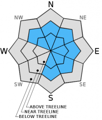
Avalanche Problem 1: Wind Slab
-
Character ?

-
Aspect/Elevation ?
-
Likelihood ?CertainVery LikelyLikelyPossible
 Unlikely
 -
Size ?HistoricVery LargeLargeSmall

Remaining wind slabs of small to possibly medium in size will be found on leeward S-SE-E-NE-N-NW aspects near and above treeline. If just the right trigger point is stumbled upon, the resulting slide could entrain enough snow to easily bury a person. Slopes 37 degrees and steeper, in complex terrain, steep chutes, convexities/roll overs, protected areas around rock outcroppings, just below ridge tops and cross loaded depressions will be the best places to encounter said wind slabs. Wind slabs will be stubborn, but not impossible to trigger. Cold, northerly aspects will host the highest sensitivity to triggering. Warmer, sunny aspects, one will find better bonded wind slabs.
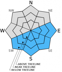
Avalanche Problem 2: Loose Wet
-
Character ?

-
Aspect/Elevation ?
-
Likelihood ?CertainVery LikelyLikelyPossible
Unlikely
-
Size ?HistoricVery LargeLargeSmall
Sunshine and warming temperatures will increase the risk of loose wet snow instabilities over the next few days. Roller balls, pin wheels, and point release snow instabilities are possible. They will be found primarily on, but not limited to, southerly facing aspects below, near, and above treeline. While typically not a immediate danger to life, these types of slides could easily knock a person off of their feet and push them into a terrain trap, over a cliff band, or into other undesirable terrain. They could even entrain enough snow to bury a person. Loose wet snow slides will become more common in the coming days. Slopes that have a long, consistent fetch can produce large loose wet avalanches on Mt Shasta. These are more common in the Spring time, but still something to think about.
Forecast Discussion
High pressure widens its stance over the area today. Strong ridging builds over the Eastern Pacific and Western North America and will mark the beginning of a dry period... to the tune of 4-5 days. Some air stagnation and fog in the valley's could be a concern. The ridge will drift eastward, slowly, and precipitation should return during the second half of next week. Wind on Mt Shasta will remain moderate this morning, decreasing later today. One should see fairly calm winds above treeline for the next couple days. Southerly winds will pick pack up on late Tuesday/Wednesday.
THIS SEASON PRECIPITATION for MT SHASTA CITY: Since October 1st (the wet season), we have received 22.62 inches of water, normal is 23.48 inches, putting us at 96% of normal. For the month of February we've received 0.13 inches of water, normal is 1.21 inches, putting us at 10% of normal, and finally... for the year of 2016 we've received 13.13 inches of water, normal is 8.27 inches, putting us at 158% of normal .
Recent Observations
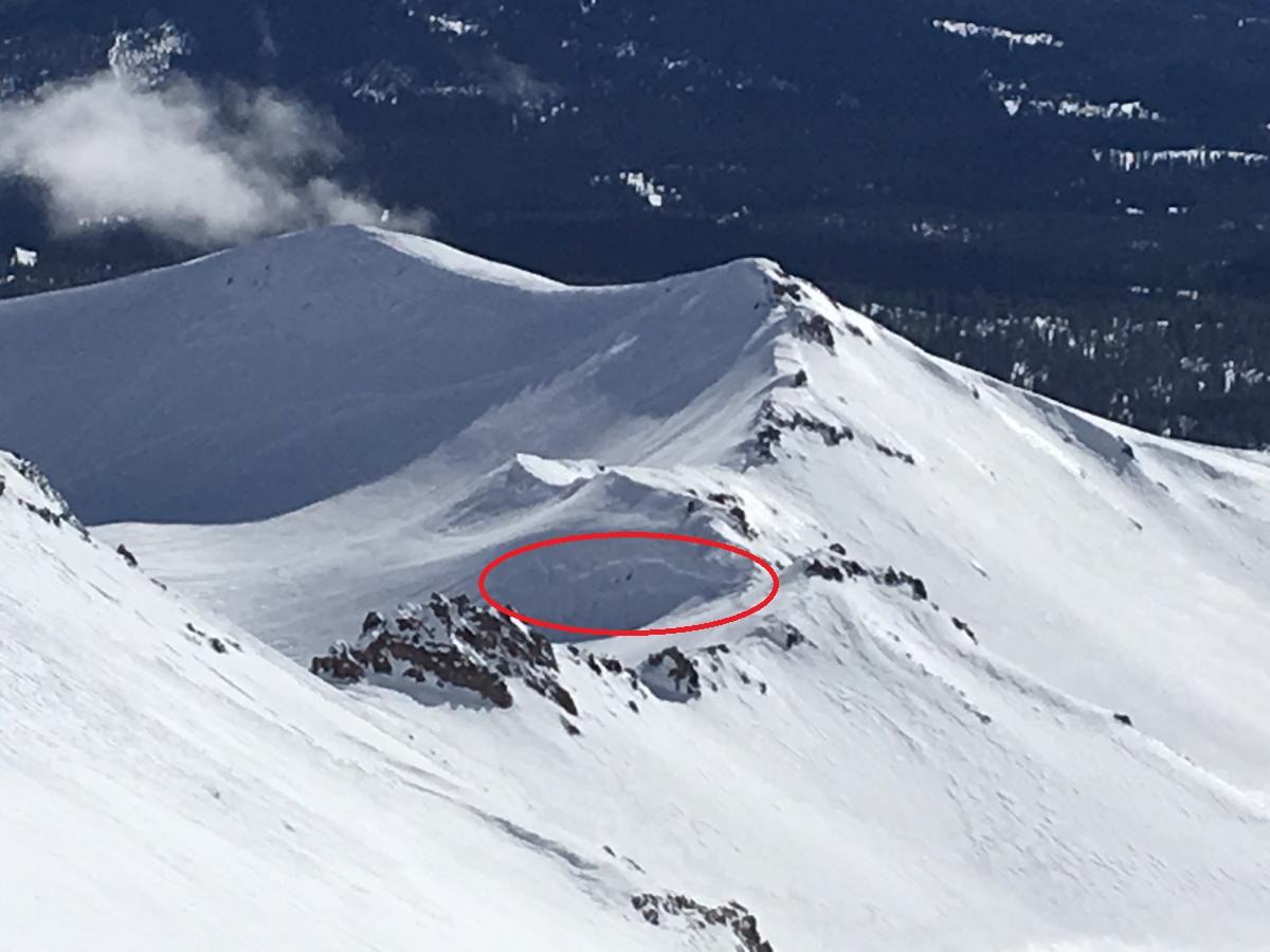
Overall, instability has been far and few between in the forecast area and weaknesses in the snowpack hard to find. Variable is a boring, albeit good word to describe snow conditions currently. Moderate to strong westerly winds during the first half of the week have scoured some areas down to a firm, icy crust. Scattered about are wind sculpted pillows and scales, wind buff powder snow in depressions and gullies, rime covered rocks at high elevation (11,000 ft and above) and wind slabs in protected areas around rock outcroppings just below ridge tops. Casaval Ridge in particular has numerous small to medium sized wind slab formations along it's serrated top. The crown of a recent wind slab avalanche (photo below) was observed on an ESE facing aspect, in a protected pocket along the top of Green Butte Ridge that drops into Old Ski Bowl. It is not known when the slide occurred, however, it is a perfect example of our current avalanche problem.
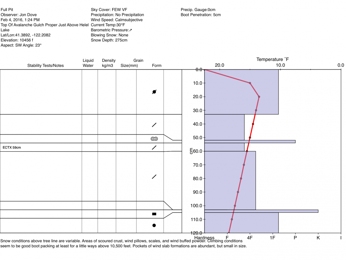
Climbing conditions are good for this time of year. Casaval, or one of the other ridge routes, would be a good option this weekend for experienced climbers. Avalanche Gulch climbing conditions are good with relatively firm snow for decent boot packing. Boot penetration of just 5 cm was recorded at Helen Lake two days ago. That being said, the variable snow conditions will present a variety of surfaces to travel over. Some post holing is possible during the warmest portions of the day and at higher elevations in wind protected areas.
For today, evaluate snow and terrain above treeline for any signs of wind loading on leeward S-SE-E-NE-N-NW aspects. Isolated terrain, on open slopes 37 degrees and steeper, the tops of chutes and couloirs, near rock outcroppings, depressions, and along roll overs/convexities will be the places that one would find and potentially trigger a wind slab avalanche. Cold, shady, northerly facing aspects likely have the highest potential for wind slab trigger. All other aspects affected by sun, wind slabs will be likely stubborn to trigger.
Pit profile at 10,456 feet near Helen Lake, Avalanche Gulch, Mt Shasta
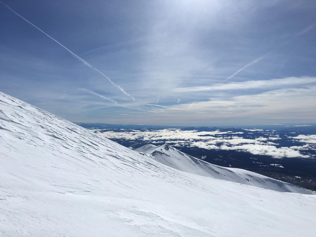
Below: Wind effected snow conditions at upper 50/50 Flat - 9,800 feet, Mt. Shasta
Below: Crown of wind slab avalanche, N/NE facing pocket along Green Butte Ridge.
_______________________________________________________________________________________________________________________________________________
LOCAL AREA ROAD, NORDIC and SNOWMOBILE PARK STATUS:
The Sand Flat cross country ski trails are in great shape and ready for your cross country skis or snow shoes. These are backcountry trails marked with blue diamonds on trees. Trails are not groomed. Snow shoers, please blaze a parallel trail to cross country skiers staying out of the skin track. These trails can be accessed via the Everett Memorial Highway. Thank you, and enjoy!
The Mt Shasta Nordic Center is open! These beautiful, groomed trails can be accessed via the Ski Park Highway. http://www.mtshastanordic.org
The Pilgrim Creek & Deer Mountain Snowmobile Parks are open! Trails are being groomed currently. Head to our "Education" tab on our website and find the snowmobile section for trail information, grooming status and other sledder resources!
The Castle Lake road is plowed to the lake. The Everett Memorial Highway is plowed to Bunny Flat.
The Five Red Flags of Avalanche Danger any time of year include: 1) Recent/current avalanche activity 2) Whumphing sounds or shooting cracks 3) Recent/current heavy snowfall 4) Strong winds transporting snow 5) Rapid warming or rain on snow.
Weather and Current Conditions
Weather Summary
Good Morning! In Mt Shasta City at 0500, we have a current temperature of 34 F, seven degrees warmer than yesterday at this time. Skies are clear with calm winds.
On Mt Shasta (South Side) in the last 24 hours...
Old Ski Bowl - 7,600 feet, the current temperature is 34 degrees F. Snow on the ground totals 119 inches with no new snow and 1-2 inches of settlement. Temperatures have ranged from 28 F to 41 F.
Grey Butte - 8,000 feet, the current temperature is 33 degrees F. Temperatures have ranged from 28 F to 38 F. Winds have been averaging 15-20 mph, with a max gust to 28 mph, northwest.
Mt Eddy Range (West side of Interstate-5)...
Castle Lake - 5,600 feet, the current temperature is 37 degrees. Temperatures have ranged from 31 F to 47 F. Snow on the ground totals 65 inches with no new snow and little settlement.
Mt Eddy - 6,500 feet, the current temperature is 31 degrees F. Temperatures have ranged from 27 F to 45 F. Snow on the ground measures 84 inches with no new snow and little settlement. Winds have averaged 2 mph, southerly in direction with a max gust of 13 mph, east/southeast.
Always check the weather before you attempt to climb Mt Shasta. Further, monitor the weather as you climb. Becoming caught on the mountain in any type of weather can compromise life and limb. Be prepared.
| 0600 temperature: | 28 |
| Max. temperature in the last 24 hours: | 41 |
| Average wind direction during the last 24 hours: | Northwest |
| Average wind speed during the last 24 hours: | 5-10 mi/hr |
| Maximum wind gust in the last 24 hours: | 28 mi/hr |
| New snowfall in the last 24 hours: | 0 inches |
| Total snow depth: | 97 inches |
Two Day Mountain Weather Forecast
Produced in partnership with the Medford NWS
| For 7000 ft to 9000 ft | |||
|---|---|---|---|
|
Saturday (4 a.m. to 10 p.m.) |
Saturday Night (10 p.m. to 4 a.m.) |
Sunday (4 a.m. to 10 p.m.) |
|
| Weather | Mostly sunny | Mostly clear | Sunny |
| Temperature (°F) | 40 | 30 | 49 |
| Wind (mi/hr) | Northwest/West 5-10 mph | North 5-10 | East 5-10 mph |
| Precipitation SWE / Snowfall (in) | / 0 | / 0 | / 0 |
| For 9000 ft to 11000 ft | |||
| Saturday | Saturday Night | Sunday | |
| Weather | Mostly sunny | Mostly clear | Sunny |
| Temperature (°F) | 2526 | 26 | 36 |
| Wind (mi/hr) | West Windy early this morning, 20-30 mph with gusts higher, decreasing later this morning to 10-20 mph and 5-10 mph later this afternoon. | North 0 | Northwest 5-10 mph |
| Precipitation SWE / Snowfall (in) | / 0 | / 0 | / 0 |

