

You are here
Avalanche Advisory for 2016-02-09 06:33:00
- EXPIRED ON February 10, 2016 @ 6:33 amPublished on February 9, 2016 @ 6:33 am
- Issued by Nick Meyers - Shasta-Trinity National Forest
Bottom Line
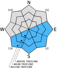
LOW avalanche danger exists at all elevations and aspects this morning. Pockets of MODERATE danger will form later in the day due to daytime warming on E-SE-S-SW aspects at all elevations on slopes steeper than 35 degrees. Other aspects, the avalanche danger will remain LOW. Wind slabs may still exist on isolated terrain features NW-N-NE-E-SE-S aspects.


Avalanche Problem 1: Loose Wet
-
Character ?

-
Aspect/Elevation ?
-
Likelihood ?CertainVery LikelyLikelyPossible
 Unlikely
 -
Size ?HistoricVery LargeLargeSmall

In the past 24 hours, the Old Ski Bowl weather station (7,600 feet) has recorded a low of 43 degrees F. All areas above freezing last night will rely soley on radiational cooling for re-freeze. This cooling will be superficial and melt quickly today. The snowpack remains transitional. Daily melt/freeze cycles have been poor due to the still low sun angle here in February. What exists is a few inches of wet snow on top of colder, dry, less consolidated old storm snow that sits on top of crust. Marginally supportable conditions exist and the snow structure is conducive to loose wet avalanche activity. Loose wet failures have been occuring at the interface between the wet snow and the colder, drier snow beneath it. This has resulted in human and naturally triggered roller balls and pinwheels. In some areas in steep terrain, out of the wind and where the best warming has occurred, larger human triggered loose wet avalanche are possible and could entrain enough debris to gouge into deeper dry snow layers, increasing depth and consequence of these slides. The wet snow over dry snow structure is easily identified by hand pits within the top layers of the snowpack on the majority of east and south aspects. Where this structure exists, avoid travel on slopes steeper than 35 degrees and stay out from under steeper terrain above.
Avalanche Problem 2: Wind Slab
-
Character ?

-
Aspect/Elevation ?
-
Likelihood ?CertainVery LikelyLikelyPossible
Unlikely
-
Size ?HistoricVery LargeLargeSmall
Remaining wind slabs of small to possibly medium in size will be found on leeward S-SE-E-NE-N-NW aspects above treeline. Complex terrain, steep chutes, convexities/roll overs, protected areas around rock outcroppings, just below ridge tops and cross loaded depressions will be the best places to find wind slabs. Wind slabs will be stubborn to trigger. Colder, northerly aspects will host the highest sensitivity to triggering. Warmer, sunny aspects, one will find better bonded wind slabs. This avalanche problem is not widespread though does warrant some caution.
Forecast Discussion
Don't fret... even though yesterday evening felt like a cool summer night, winter is still going to deliver, eventually. Unseasonably warm temperatures in February like this, up to 20 degrees above normal, is only expected once every 5-10 years! (Nat'l Weather Service) A changing pattern will begin to take form over the next couple days. This change will start with more normal temperatures (cooling) for Wednesday as onshore flow returns thus putting a close to the freakishly warm temps. Temperatures will feel more winter like by late Friday and Saturday when also a bit of precipitation is expected. Water amounts don't look like much...more on that in the coming days. Expect mostly clear skies with increasing clouds and windy above treeline over the next couple days.
THIS SEASON PRECIPITATION for MT SHASTA CITY: Since October 1st (the wet season), we have received 22.62 inches of water, normal is 24.22 inches, putting us at 93% of normal. For the month of February we've received 0.13 inches of water, normal is 1.95 inches, putting us at 6% of normal, and finally... for the year of 2016 we've received 13.13 inches of water, normal is 9.01 inches, putting us at 145% of normal .
Recent Observations
The snowpack is still in transition. Snow surface conditions remain variable and sunny skies and warm temperatures are working the melt/freeze magic that will eventually lead to corn snow formation... perhaps before our next storm. The only sign of instability lately has been a few roller balls on southerly facing aspects near and below treeline. Reports from a group on Casaval ridge who had dug two snow stability pits to perform extended column tests had results of ECTN 17 and ECTN 21 in areas of wind slab development. These tests has moderate failures with no propagation. Wind slabs have been stubborn to trigger, and will continue to gain strength over the coming days. Overall, snow instabilities will continue to be few and far between in the forecast area with any weakness in the snowpack hard to find.
Climbing conditions are good for this time of year. Casaval, or one of the other ridge routes, would be a good option over the next few days for experienced climbers. Avalanche Gulch climbing conditions are good with relatively firm snow for decent boot packing. Boot penetration of just 5 cm was recorded at Helen Lake this last Thursday. That being said, the variable snow conditions will present a variety of surfaces to travel over. Some post holing is possible during the warmest portions of the day and at higher elevations in wind protected areas.
________________________________________________________________________________________________________________________________________
LOCAL AREA ROAD, NORDIC and SNOWMOBILE PARK STATUS:
The Sand Flat cross country ski trails are in great shape and ready for your cross country skis or snow shoes. These are backcountry trails marked with blue diamonds on trees. Trails are not groomed. Snow shoers, please blaze a parallel trail to cross country skiers staying out of the skin track. These trails can be accessed via the Everett Memorial Highway. Thank you, and enjoy!
The Mt Shasta Nordic Center is open! These beautiful, groomed trails can be accessed via the Ski Park Highway. http://www.mtshastanordic.org
The Pilgrim Creek & Deer Mountain Snowmobile Parks are open! Trails are being groomed currently. Head to our "Education" tab on our website and find the snowmobile section for trail information, grooming status and other sledder resources!
The Castle Lake road is plowed to the lake. The Everett Memorial Highway is plowed to Bunny Flat.
The Five Red Flags of Avalanche Danger any time of year include: 1) Recent/current avalanche activity 2) Whumphing sounds or shooting cracks 3) Recent/current heavy snowfall 4) Strong winds transporting snow 5) Rapid warming or rain on snow.
Weather and Current Conditions
Weather Summary
Good Morning! In Mt Shasta City at 0500, we have a current temperature of 34 F, one degree cooler than yesterday at this time. Skies are clear with calm winds.
On Mt Shasta (South Side) in the last 24 hours...
Old Ski Bowl - 7,600 feet, the current temperature is 46 degrees F. Snow on the ground totals 113 inches with no new snow and 2.5 inches of settlement. Temperatures have ranged from 43 F to 52 F.
Grey Butte - 8,000 feet, the current temperature is 48 degrees F. Temperatures have ranged from 44 F to 53 F. Winds have been averaging 30 mph out of the east/southeast with a max gust to 56 mph, east. Early this morning, it looks like the wind has been diminishing, averaging 10-15 mph with gusts to 21 mph, southeast, since 0100.
Mt Eddy Range (West side of Interstate-5)...
Castle Lake - 5,600 feet, the current temperature is 42 degrees. Temperatures have ranged from 42 F to 56 F. Snow on the ground totals 63 inches with no new snow and little settlement.
Mt Eddy - 6,500 feet, the current temperature is 38 degrees F. Temperatures have ranged from 38 F to 50 F. Snow on the ground measures 80 inches with no new snow and 1 inch of settlement. Winds have averaged 3 mph, southwest in direction with a max gust of 14 mph, west/southwest.
Always check the weather before you attempt to climb Mt Shasta. Further, monitor the weather as you climb. Becoming caught on the mountain in any type of weather can compromise life and limb. Be prepared.
| 0600 temperature: | 41 |
| Max. temperature in the last 24 hours: | 56 |
| Average wind direction during the last 24 hours: | Southeast |
| Average wind speed during the last 24 hours: | 20-30 mi/hr |
| Maximum wind gust in the last 24 hours: | 56 mi/hr |
| New snowfall in the last 24 hours: | 0 inches |
| Total snow depth: | 92 inches |
Two Day Mountain Weather Forecast
Produced in partnership with the Medford NWS
| For 7000 ft to 9000 ft | |||
|---|---|---|---|
|
Tuesday (4 a.m. to 10 p.m.) |
Tuesday Night (10 p.m. to 4 a.m.) |
Wednesday (4 a.m. to 10 p.m.) |
|
| Weather | Sunny | Mostly clear/Breezy | Mostly Sunny |
| Temperature (°F) | 52 | 39 | 51 |
| Wind (mi/hr) | South/Southeast 10-15 mph | South/Southeast 10-15 mph | South/Southeast 5-10 mph |
| Precipitation SWE / Snowfall (in) | / 0 | / 0 | / 0 |
| For 9000 ft to 11000 ft | |||
| Tuesday | Tuesday Night | Wednesday | |
| Weather | Sunny | Clear and Breezy | Sunny and windy |
| Temperature (°F) | 35 | 33 | 33 |
| Wind (mi/hr) | South/Southwest 20-30 mph with gusts to 40 mph | Southwest 0 | Southwest 30-40 mph with gusts to 50 mph |
| Precipitation SWE / Snowfall (in) | / 0 | / 0 | / 0 |

