

You are here
Avalanche Advisory for 2016-02-11 07:06:46
- EXPIRED ON February 12, 2016 @ 7:06 amPublished on February 11, 2016 @ 7:06 am
- Issued by Jon Dove - Shasta-Trinity National Forest
Bottom Line
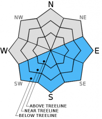
LOW avalanche danger will exist on all aspects and elevations in the morning hours. As as the day warms up, pockets of MODERATE danger may develop on E-SE-S-SW aspects at all elevations on slopes steeper than 35 degrees due to loose wet avalanche instabilities. Avalanche danger will remain LOW on cooler W-NW-N-NE aspects. Wind slabs may still exist on isolated terrain features NW-N-NE-E-SE-S aspects.


Avalanche Problem 1: Loose Wet
-
Character ?

-
Aspect/Elevation ?
-
Likelihood ?CertainVery LikelyLikelyPossible
 Unlikely
 -
Size ?HistoricVery LargeLargeSmall

The night time low temperature recorded at the Old Ski Bowl weather station (elevation 7,600 ft.) was 39 degrees. All areas with above freezing temperatures overnight rely solely on radiational cooling for re-freeze. Any refreezing of the snow's surface will be superficial, and melt quickly today. The snowpack remains transitional with generally soft snow conditions persisting over the forecast area. Daily melt/freeze cycles have been effective in transforming the snow surface in to corn snow conditions. What exists is a few centemeters of wet snow on top of a melt-freeze crust with slightly lighter soft snow underneath. Supportable conditions exist and the snow structure could be conducive to loose wet avalanche activity in the late afternoon hours. Loose wet failures could occurr at the interface between the wet snow and the colder, drier snow beneath it. This has resulted in human and naturally triggered roller balls and pinwheels. In some areas in steep terrain, out of the wind and where the best warming has occurred, larger human triggered loose wet avalanche are possible and could entrain enough debris to gouge into deeper dry snow layers, increasing depth and consequence of these slides. The wet snow over dry snow structure is easily identified by hand pits within the top layers of the snowpack on the majority of east and south aspects. Where this structure exists, avoid travel on slopes steeper than 35 degrees, exposure to terrain traps such as gullies and cliff bands, and stay out from under steeper terrain above.
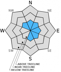
Avalanche Problem 2: Wind Slab
-
Character ?

-
Aspect/Elevation ?
-
Likelihood ?CertainVery LikelyLikelyPossible
Unlikely
-
Size ?HistoricVery LargeLargeSmall
Remaining wind slabs of small to possibly medium in size will be found on leeward S-SE-E-NE-N-NW aspects above treeline. Complex terrain, steep chutes, convexities/roll overs, protected areas around rock outcroppings, just below ridge tops and cross loaded depressions will be the best places to find wind slabs. Wind slabs will be stubborn to trigger. Colder, northerly aspects will host the highest sensitivity to any possible triggering. Warmer, sunny aspects, one will find better bonded wind slabs. This avalanche problem is not widespread though does warrant some caution.
Forecast Discussion
Mild temperatures persisted once again yesterday making for great conditions to get outside and enjoy the snow. Warmer than normal temperatures will be with us again today, but they have cooled slightly. The ridge of high pressure has slid to the east with a southwest flow allowing high clouds to stream over the region, as was the case yesterday. Today's weather will very similar to yesterday's with increasing clouds in the afternoon. Breezy conditions will be encountered above treeline at mid-mountain elevations (10,000 ft) and higher coming from the south/southwest. They will remain fairly steady in speed over the next 48 hours. The outlook for the weekend sees a chance for some light precipitation. Total water amounts, however, will be minimal so don't expect to break out your powder skis for the president's day weekend.
THIS SEASON PRECIPITATION for MT SHASTA CITY: Since October 1st (the wet season), we have received 22.62 inches of water, normal is 24.69 inches, putting us at 91% of normal. For the month of February we've received 0.13 inches of water, normal is 2.42 inches, putting us at 5% of normal, and finally... for the year of 2016 we've received 13.13 inches of water, normal is 9.48 inches, putting us at 138% of normal .
Recent Observations
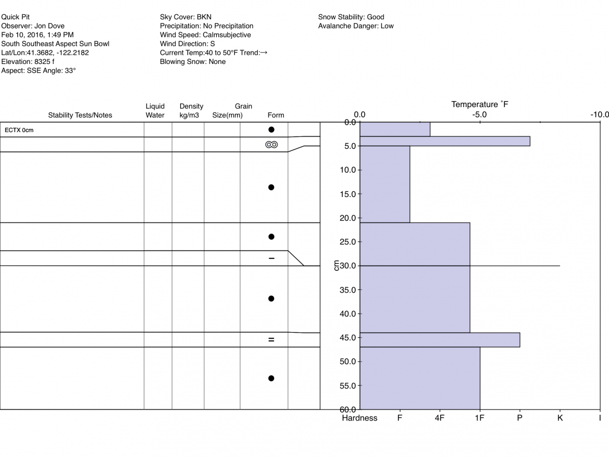
Observations made yesterday on a ski tour above treeline in Sun Bowl confirmed predictions of corn snow development up to at least 8,500 ft. in elevation in the afternoon hours. A snow study pit (see graph below) was dug to check consolidation of snow layers and test stability. What was found was as one might guess after several days of above normal temperatures and plenty of sunshine. Wet snow readily bonding with layers beneath. An extended column test was performed resulting in a score of ECTX. There were no signs of loose wet or wind slab avalanche instabilities. Wind slab formations that developed Wednesday of last week have been stubborn to trigger, and will continue to gain strength with more sun and mild temperatures. Overall, snow instabilities will continue to be fairly limited within the forecast area. Any weakness in the snowpack will be hard to find.
Climbing conditions are good for this time of year, and continue to improve with the unusually warm weather. Casaval, or one of the other ridge routes, would be a good option for experienced climbers. Avalanche Gulch climbing conditions are good with relatively firm snow for decent boot packing. Boot penetration of just 5 cm was recorded at Helen Lake at the end of last week. That being said, variable snow conditions at higher elevations (10,000 ft. and above) will present a variety of surfaces to travel over. Some post holing is possible during the warmest portions of the day and at higher elevations in wind protected areas
Pit Profile-SSE Aspect in Sun Bowl:
________________________________________________________________________________________________________________________________________
LOCAL AREA ROAD, NORDIC and SNOWMOBILE PARK STATUS:
The Sand Flat cross country ski trails are in great shape and ready for your cross country skis or snow shoes. These are backcountry trails marked with blue diamonds on trees. Trails are not groomed. Snow shoers, please blaze a parallel trail to cross country skiers staying out of the skin track. These trails can be accessed via the Everett Memorial Highway. Thank you, and enjoy!
The Mt Shasta Nordic Center is open! These beautiful, groomed trails can be accessed via the Ski Park Highway. http://www.mtshastanordic.org
The Pilgrim Creek & Deer Mountain Snowmobile Parks are open! Trails are being groomed currently. Head to our "Education" tab on our website and find the snowmobile section for trail information, grooming status and other sledder resources!
The Castle Lake road is plowed to the lake. The Everett Memorial Highway is plowed to Bunny Flat.
The Five Red Flags of Avalanche Danger any time of year include: 1) Recent/current avalanche activity 2) Whumphing sounds or shooting cracks 3) Recent/current heavy snowfall 4) Strong winds transporting snow 5) Rapid warming or rain on snow.
Weather and Current Conditions
Weather Summary
Good Morning! In Mt Shasta City at 0500, we have a current temperature of 40 F, five degrees warmer than yesterday at this time. Skies are fair with calm winds.
On Mt Shasta (South Side) in the last 24 hours...
Old Ski Bowl - 7,600 feet, the current temperature is 44 degrees F. Snow on the ground totals 111 inches with no new snow and 1 inch of settlement. Temperatures have ranged from 49 F to 47F.
Grey Butte - 8,000 feet, the current temperature is 44 degrees F. Temperatures have ranged from 38 F to 45 F. Winds have been averaging 10-15 mph out of the west/northwest with a max gust to 28 mph, WNW.
Mt Eddy Range (West side of Interstate-5)...
Castle Lake - 5,600 feet, the current temperature is 45 degrees. Temperatures have ranged from 44 F to 54 F. Snow on the ground totals 61 inches with no new snow and 1 inch of settlement.
Mt Eddy - 6,500 feet, the current temperature is 39 degrees F. Temperatures have ranged from 38 F to 49 F. Snow on the ground measures 79 inches with no new snow and 1 inch of settlement. Winds have averaged 2 mph, south/southwest in direction with a max gust of 10 mph, south.
Always check the weather before you attempt to climb Mt Shasta. Further, monitor the weather as you climb. Becoming caught on the mountain in any type of weather can compromise life and limb. Be prepared.
| 0600 temperature: | 38 |
| Max. temperature in the last 24 hours: | 54 |
| Average wind direction during the last 24 hours: | west/northwest |
| Average wind speed during the last 24 hours: | 10-15 mi/hr |
| Maximum wind gust in the last 24 hours: | 28 mi/hr |
| New snowfall in the last 24 hours: | 0 inches |
| Total snow depth: | 89 inches |
Two Day Mountain Weather Forecast
Produced in partnership with the Medford NWS
| For 7000 ft to 9000 ft | |||
|---|---|---|---|
|
Thursday (4 a.m. to 10 p.m.) |
Thursday Night (10 p.m. to 4 a.m.) |
Friday (4 a.m. to 10 p.m.) |
|
| Weather | Partly sunny then mostly cloudy with a 20% chance of isolated rain showers. | Mostly cloudy | Mostly cloudy with a 30% chance of rain showers |
| Temperature (°F) | 49 | 33 | 45 |
| Wind (mi/hr) | South 5-10 mph with gusts to 35 mph | South 5-10 mph | South 5-10 mph |
| Precipitation SWE / Snowfall (in) | / 0 | / 0 | / 0 |
| For 9000 ft to 11000 ft | |||
| Thursday | Thursday Night | Friday | |
| Weather | Mostly cloudy with isolated snow showers and windy | Mostly cloudy with a 30% chance snow after 4 am and windy | Mostly cloudy with a 30% chance snow before 10 am, then chance of snow showers after 10 am. |
| Temperature (°F) | 34 | 29 | 29 |
| Wind (mi/hr) | Southwest 30-35 mph with gusts to 40 mph | Southwest 0 | Southwest 30-35 mph with gusts to 40 mph |
| Precipitation SWE / Snowfall (in) | / 0 | / 0 | / 0 |

