

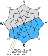
You are here
Avalanche Advisory for 2016-02-12 06:32:57
- EXPIRED ON February 13, 2016 @ 6:32 amPublished on February 12, 2016 @ 6:32 am
- Issued by Jon Dove - Shasta-Trinity National Forest
Bottom Line
The avalanche danger for this morning is LOW. As as the day warms up, pockets of MODERATE danger will form on sun exposed E-SE-S-SW aspects at elevations below 11,000 ft. on slopes steeper than 35 degrees due to loose wet snow issues. Human triggered point-release loose wet avalanches, roller balls, and pinwheels will be possible and could entrain enough snow to be an issue for backcountry travelers. Normal caution is advised.


Avalanche Problem 1: Loose Wet
-
Character ?

-
Aspect/Elevation ?
-
Likelihood ?CertainVery LikelyLikelyPossible
 Unlikely
 -
Size ?HistoricVery LargeLargeSmall

Night time low temperature have remained above freezing near and below treeline. The snow at elevations with overnight temperatures above freezing rely solely on radiational cooling for re-freeze. Refreezing of the snow's surface will improve as temperatures gradually cool over the next couple of days. The snowpack continues to consolidate with mild temperatures encouraging rounding and bonding of snow crystals. Overall, soft surface snow conditions will be found throughout the forecast area. Daily melt/freeze cycles have been effective in transforming the snow surface into corn snow conditions. Loose wet failures will be limited to surface snow, and could occur on southerly facing aspects resulting in both human and naturally triggered roller balls and pinwheels. In some areas in steep terrain, out of the wind and where the best warming has occurred, larger human triggered loose wet avalanche are possible and could entrain enough snow to be a problem for backcountry travelers. During the warmest parts of the day, on southerly facing aspects, avoid travel on slopes steeper than 35 degrees, exposure to terrain traps such as gullies and cliff bands, and stay out from under steeper terrain above.
Forecast Discussion
A cold front will move over the area early today bringing high clouds, but little else. High pressure will follow close behind bringing dry weather and sunshine through Saturday. A warm front will then bring more clouds and a very slight chance for some light precipitation Saturday night into Sunday morning. Precipitation models, however, show water measurements of zero through Tuesday of next week as high pressure returns late Sunday. Winds will be light to moderate with a southerly direction shifting to more northerly Saturday. Temperatures will gradually cool by few degrees through the weekend. Our current dry streak will continue for several more days.
THIS SEASON PRECIPITATION for MT SHASTA CITY: Since October 1st (the wet season), we have received 22.62 inches of water, normal is 24.93 inches, putting us at 90% of normal. For the month of February we've received 0.13 inches of water, normal is 2.66 inches, putting us at 4% of normal, and finally... for the year of 2016 we've received 13.13 inches of water, normal is 9.72 inches, putting us at 135% of normal .
Recent Observations
Observations made at Castle Lake yesterday revealed a variety of conditions depending on aspect. The southeasterly facing Right Peak did not refreeze overnight and was soft, corn snow with some loose wet instabilities in the form of roller balls. Middle Peak, with a more northeast facing aspect, presented variable snow conditions. Today's weather will be similar to the last few days with high clouds and some sunshine. The impact on the snow will be similar as well, with aspect dictating the conditions. Southerly aspects will soften, and more northerly facing aspects will remain variable. Corn snow has arrived, and will comprise most of the loose wet instabilities in the form of the aforementioned roller balls, as well as pinwheels, point-releases, and possibly some loose wet avalanches. In the afternoon hours human trigger of wet snow instabilities will be possible. Wind slab formations may still exist at high elevations (11,000 ft. and above) in isolated pockets. Trigger of wind slab avalanches is unlikely, however. Overall, any weakness in the snowpack will be limited to loose wet surface snow instabilities during the warmest parts of the day. Normal caution is advised, and safe travel techniques are recommend. Stay well spaced, cross suspect slopes one at a time, and maintain good communication amongst party members.
Climbing conditions continue to improve with the current mild temperatures and mostly sunny weather over the past week. An ascent of Casaval, Green Butte, or Sargent's Ridge would be a great option for experienced climbers. Avalanche Gulch climbing conditions are good as well, with relatively firm snow for decent boot packing. Boot penetration of just 5 cm was recorded at Helen Lake at the end of last week. That being said, variable snow conditions at higher elevations (10,000 ft. and above) will present a variety of surfaces to travel over. Some post holing is possible during the warmest portions of the day at lower elevations in wet snow, and at higher elevations in un consolidated snow in wind protected areas.
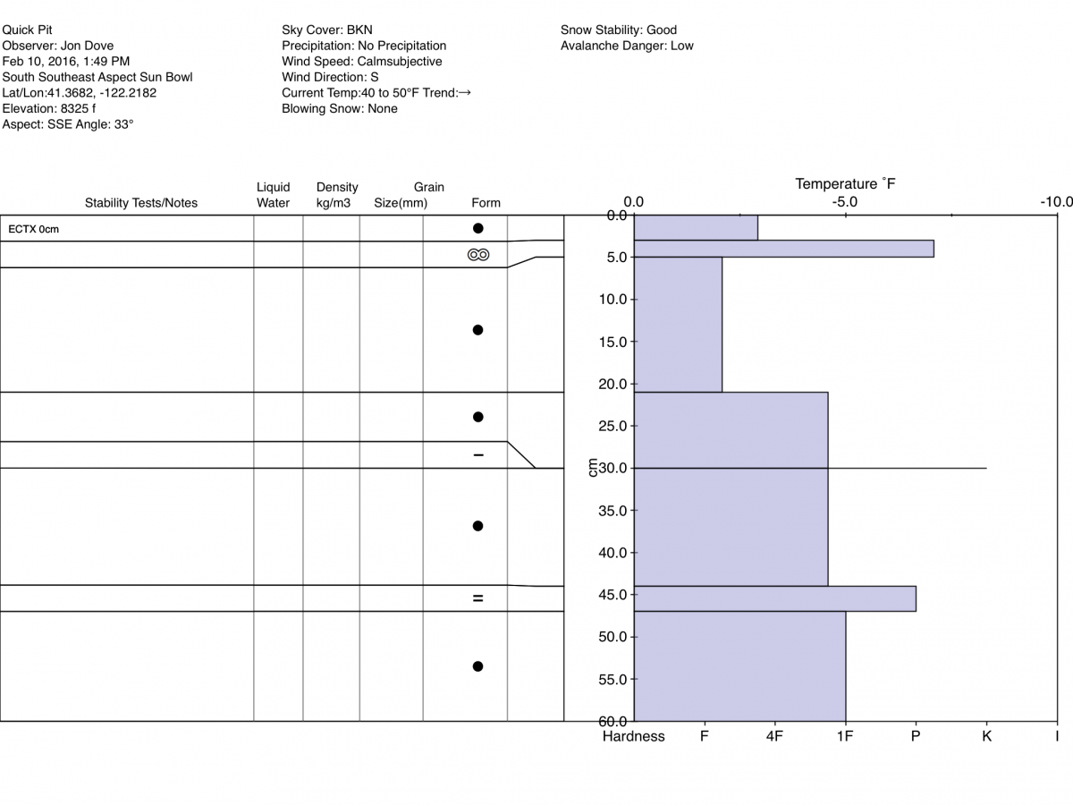
Pit Profile taken on 4/10/2016 on a SSE Aspect in Sun Bowl:
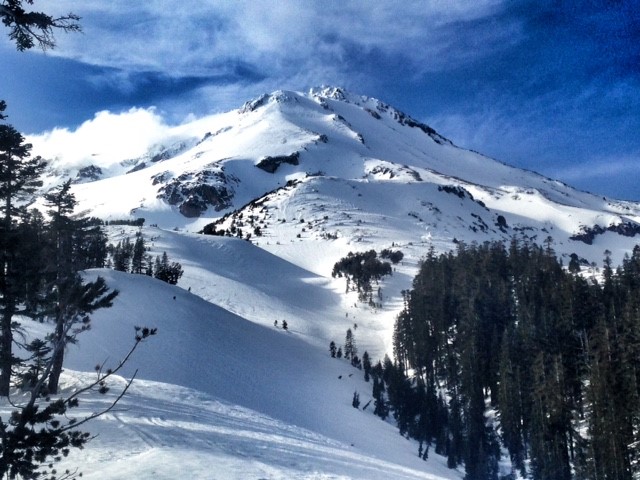
East side of Mount Shasta on 2/11/2016:
________________________________________________________________________________________________________________________________________
LOCAL AREA ROAD, NORDIC and SNOWMOBILE PARK STATUS:
The Sand Flat cross country ski trails are in great shape and ready for your cross country skis or snow shoes. These are backcountry trails marked with blue diamonds on trees. Trails are not groomed. Snow shoers, please blaze a parallel trail to cross country skiers staying out of the skin track. These trails can be accessed via the Everett Memorial Highway. Thank you, and enjoy!
The Mt Shasta Nordic Center is open! These beautiful, groomed trails can be accessed via the Ski Park Highway. http://www.mtshastanordic.org
The Pilgrim Creek & Deer Mountain Snowmobile Parks are open! Trails are being groomed currently. Head to our "Education" tab on our website and find the snowmobile section for trail information, grooming status and other sledder resources!
The Castle Lake road is plowed to the lake. The Everett Memorial Highway is plowed to Bunny Flat.
The Five Red Flags of Avalanche Danger any time of year include: 1) Recent/current avalanche activity 2) Whumphing sounds or shooting cracks 3) Recent/current heavy snowfall 4) Strong winds transporting snow 5) Rapid warming or rain on snow.
Weather and Current Conditions
Weather Summary
Good Morning! In Mt Shasta City at 0500, we have a current temperature of 36 F, four degrees cooler than yesterday at this time. Skies are overcast with calm winds.
On Mt Shasta (South Side) in the last 24 hours...
Old Ski Bowl - 7,600 feet, the current temperature is 38 degrees F. Snow on the ground totals 110 inches with no new snow and 1 inch of settlement. Temperatures have ranged from 36 F to 49F.
Grey Butte - 8,000 feet, the current temperature is 35 degrees F. Temperatures have ranged from 35 F to 45 F. Winds have been averaging 10-15 mph variable in direction with a max gust to 28 mph, WNW.
Mt Eddy Range (West side of Interstate-5)...
Castle Lake - 5,600 feet, the current temperature is 39 degrees. Temperatures have ranged from 39 F to 58 F. Snow on the ground totals 61 inches with no new snow and little settlement.
Mt Eddy - 6,500 feet, the current temperature is 37 degrees F. Temperatures have ranged from 37 F to 49 F. Snow on the ground measures 78 inches with no new snow and 1 inch of settlement. Winds have averaged 2 mph, southerly in direction with a max gust of 10 mph, southwest.
Always check the weather before you attempt to climb Mt Shasta. Further, monitor the weather as you climb. Becoming caught on the mountain in any type of weather can compromise life and limb. Be prepared.
| 0600 temperature: | 38 |
| Max. temperature in the last 24 hours: | 51 |
| Average wind direction during the last 24 hours: | Variable |
| Average wind speed during the last 24 hours: | 10-15 mi/hr |
| Maximum wind gust in the last 24 hours: | 28 mi/hr |
| New snowfall in the last 24 hours: | 0 inches |
| Total snow depth: | 87 inches |
Two Day Mountain Weather Forecast
Produced in partnership with the Medford NWS
| For 7000 ft to 9000 ft | |||
|---|---|---|---|
|
Friday (4 a.m. to 10 p.m.) |
Friday Night (10 p.m. to 4 a.m.) |
Saturday (4 a.m. to 10 p.m.) |
|
| Weather | Partly sunny | Mostly cloudy, then gradually becoming mostly clear | Mostly sunny |
| Temperature (°F) | 50 | 29 | 46 |
| Wind (mi/hr) | South 5-10 mph with gusts to 30 mph | Northwest 5-10 mph | North 5-10 mph |
| Precipitation SWE / Snowfall (in) | / 0 | / 0 | / 0 |
| For 9000 ft to 11000 ft | |||
| Friday | Friday Night | Saturday | |
| Weather | Partly sunny | Partly cloudy | Mostly sunny |
| Temperature (°F) | 30 | 27 | 28 |
| Wind (mi/hr) | Southwest 30-35 mph with gusts to 45 mph | Southwest 0 | Northwest 20-25 mph with gusts to 35 mph |
| Precipitation SWE / Snowfall (in) | / 0 | / 0 | / 0 |

