

You are here
Avalanche Advisory for 2016-02-13 06:35:39
- EXPIRED ON February 14, 2016 @ 6:35 amPublished on February 13, 2016 @ 6:35 am
- Issued by Nick Meyers - Shasta-Trinity National Forest
Bottom Line
The avalanche danger is LOW across the forecast area for all elevations and aspects.
Loose wet instabilities will be little to none as temperatures have cooled a few degrees and wind and clouds will limit solar input.
Continue to practice safe backcountry travel methods and always be on the lookout for signs of instability.


Avalanche Problem 1: Loose Wet
-
Character ?

-
Aspect/Elevation ?
-
Likelihood ?CertainVery LikelyLikelyPossible
 Unlikely
 -
Size ?HistoricVery LargeLargeSmall

Better overnight re-freeze and expected partially cloudy skies with northwest wind will keep loose wet instabilities at bay today. Only on the warmest, most protected albeit open slopes below treeline could experience some roller ball activity at the warmest times of the day... That said, instabilities will likely not cause any problems for backcountry users. Several days of warm weather has consolidated the snow quite well and loose wet slides have become smaller and more isolated.
Always be monitoring the condition of the snowpack... sinking into moist/saturated snow can indicate that enough wet snow exists on a slope for a loose wet avalanche. Small roller balls and pinwheels are great indicators that a larger slide is possible. It may be time to find a different aspect or start your tour a little earlier next time! "The fox fears not the one who boasts by night but the one who rises early in the morning!"
Forecast Discussion
A slight disturbance this weekend for the area that will bring very light precipitation and snow levels near 7 to 8,000 feet tonight and tomorrow. Any precipitation will be minimal and light. Were talking about .05 inches of water perhaps which could translate into a dusting of snow in the hills. The brunt of this storm will stay north of us. A fast moving jetstream is driving the weather to the northern part of Oregon and north of the forecast area. Thus, we'll likely just see increasing clouds and again, perhaps some light rain/snow. Cold air comes inland this evening cooling things off a bit and wind will pick up out of the northwest and blow steady above treeline 20-30 mph with gusts into the 40's to 50 mph range. This mid winter dry spell we sit in currently is expected to remain for the near future. The early part of next week, high pressure builds northward along the coast. Models suggest a weaking ridge mid-week and the next best chance of rain/snow is later next week, although predictions are for light precipitation amounts.
The bigger picture... February is a bit of a wild card and climate experts believe we'll finish up February with in and out of spring like weather. March however, could be big...a very wet month is predicted with up to 15 inches of rain possible for the month of March. It seems probable that we'll enter into full on winter conditions again and powder will return! Rest up!
THIS SEASON PRECIPITATION for MT SHASTA CITY: Since October 1st (the wet season), we have received 22.62 inches of water, normal is 25.17 inches, putting us at 89% of normal. For the month of February we've received 0.13 inches of water, normal is 2.90 inches, putting us at 4% of normal, and finally... for the year of 2016 we've received 13.13 inches of water, normal is 9.96 inches, putting us at 131% of normal .
Recent Observations
No new and notable observations have been reported. The snowpack remains variable and while one can find some spring like corn snow out there, conditions are mixed depending on aspect and elevation. Wet loose instabilities will be far and few between as well as any other forms of avalanche danger today. Temperatures cooled a bit last night. Today, wind and some clouds will keep the snow in place and avalanche conditions pretty darn safe out there. One will find breakable crusts, supportable frozen snow, softer/colder snow, icy patches, old small wind slabs.... you get it! Snowpits have not revealed any signs of instability. Have fun and continue to take normal precautions while traveling in the backcountry.
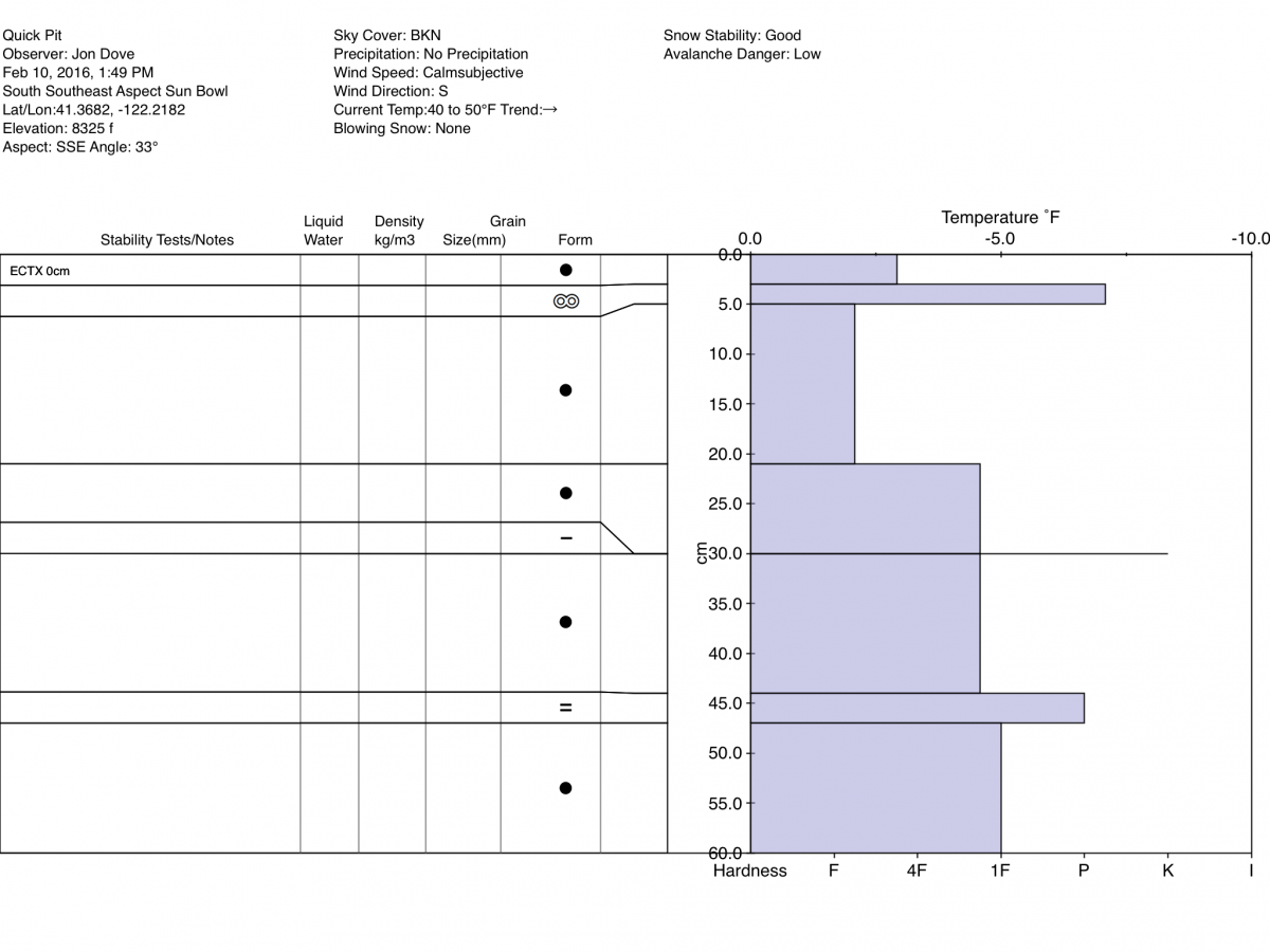
Pit Profile taken on 4/10/2016 on a SSE Aspect in Sun Bowl:
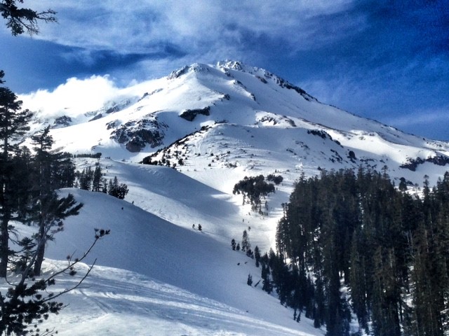
East side of Mount Shasta on 2/11/2016:
________________________________________________________________________________________________________________________________________
LOCAL AREA ROAD, NORDIC and SNOWMOBILE PARK STATUS:
The Sand Flat cross country ski trails are in great shape and ready for your cross country skis or snow shoes. These are backcountry trails marked with blue diamonds on trees. Trails are not groomed. Snow shoers, please blaze a parallel trail to cross country skiers staying out of the skin track. These trails can be accessed via the Everett Memorial Highway. Thank you, and enjoy!
The Mt Shasta Nordic Center is open! These beautiful, groomed trails can be accessed via the Ski Park Highway. http://www.mtshastanordic.org
The Pilgrim Creek & Deer Mountain Snowmobile Parks are open! Trails are being groomed currently. Head to our "Education" tab on our website and find the snowmobile section for trail information, grooming status and other sledder resources!
The Castle Lake road is plowed to the lake. The Everett Memorial Highway is plowed to Bunny Flat.
The Five Red Flags of Avalanche Danger any time of year include: 1) Recent/current avalanche activity 2) Whumphing sounds or shooting cracks 3) Recent/current heavy snowfall 4) Strong winds transporting snow 5) Rapid warming or rain on snow.
Weather and Current Conditions
Weather Summary
Good Morning! In Mt Shasta City at 0500, we have a current temperature of 38 F, two degrees warmer than yesterday at this time. Skies are overcast with calm winds.
On Mt Shasta (South Side) in the last 24 hours...
Old Ski Bowl - 7,600 feet, the current temperature is 38 degrees F. Snow on the ground totals 110 inches with no new snow and 2 inches of settlement. Temperatures have ranged from 35 F to 48F.
Grey Butte - 8,000 feet, the current temperature is 36 degrees F. Temperatures have ranged from 33 F to 44 F. Winds have been averaging 15 mph northwest in direction with a max gust to 42 mph, NW.
Mt Eddy Range (West side of Interstate-5)...
Castle Lake - 5,600 feet, the current temperature is 32 degrees. Temperatures have ranged from 30 F to 54 F. Snow on the ground totals 61 inches with no new snow and little settlement.
Mt Eddy - 6,500 feet, the current temperature is 30 degrees F. Temperatures have ranged from 29 F to 46 F. Snow on the ground measures 78 inches with no new snow and .5 inches of settlement. Winds have averaged 1-2 mph, southwest in direction with a max gust of 6 mph, southwest.
Always check the weather before you attempt to climb Mt Shasta. Further, monitor the weather as you climb. Becoming caught on the mountain in any type of weather can compromise life and limb. Be prepared.
| 0600 temperature: | 37 |
| Max. temperature in the last 24 hours: | 48 |
| Average wind direction during the last 24 hours: | Northwest |
| Average wind speed during the last 24 hours: | 10-15 mi/hr |
| Maximum wind gust in the last 24 hours: | 42 mi/hr |
| New snowfall in the last 24 hours: | 0 inches |
| Total snow depth: | 86 inches |
Two Day Mountain Weather Forecast
Produced in partnership with the Medford NWS
| For 7000 ft to 9000 ft | |||
|---|---|---|---|
|
Saturday (4 a.m. to 10 p.m.) |
Saturday Night (10 p.m. to 4 a.m.) |
Sunday (4 a.m. to 10 p.m.) |
|
| Weather | Mostly sunny | 20% chance of rain after 10pm, mostly cloudy, breezy | 50% chance of rain, mostly cloudy, breezy |
| Temperature (°F) | 47 | 34 | 47 |
| Wind (mi/hr) | Northwest 5-10 mph with gusts to 30 mph | Northwest 10-20 mph | Northwest 10-20 mph |
| Precipitation SWE / Snowfall (in) | / 0 | / 0 | / 0 |
| For 9000 ft to 11000 ft | |||
| Saturday | Saturday Night | Sunday | |
| Weather | Mostly sunny, windy | 30% chance of snow after 10pm, mostly cloudy, windy | 50% chance of snow, mostly cloudy, windy |
| Temperature (°F) | 28 | 25 | 26 |
| Wind (mi/hr) | West/Northwest 20-30 mph | Northwest 0 | North/Northwest 25-35 mph, increasing |
| Precipitation SWE / Snowfall (in) | / 0 | / 0 | / 0 |

