

You are here
Avalanche Advisory for 2016-02-14 06:46:16
- EXPIRED ON February 15, 2016 @ 6:46 amPublished on February 14, 2016 @ 6:46 am
- Issued by Nick Meyers - Shasta-Trinity National Forest
Bottom Line
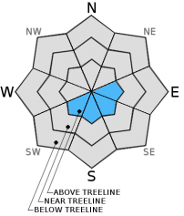
The avalanche danger is LOW across the forecast area for all elevations and aspects.
Very small, isolated wind slabs are possible later in the day on easterly and southerly facing, leeward aspects. Newly formed wind slabs will be shallow, small and not a major concern.
Use normal caution in the backcountry today.


Avalanche Problem 1: Wind Slab
-
Character ?

-
Aspect/Elevation ?
-
Likelihood ?CertainVery LikelyLikelyPossible
 Unlikely
 -
Size ?HistoricVery LargeLargeSmall

Less than a tenth of an inch of precipitation is forecast to fall today with snow levels near 8,000 feet. This small disturbance in weather could bring up to an inch of new snow above treeline. With a bit of new snow accompanied by our famous northwesterlies, it is possible that very small wind slabs could form on leeward SW-S-SE-E aspects above treeline, later this afternoon. While worth mentioning, wind slabs will likely not reach a large enough size to pose a threat to mountain travelers. Slabs will be isolated and again, small. Wind slabs could be sensitive during the late afternoon hours near the end of the storm, though the depth of newly formed slabs will be only a few inches deep at most and thus we've kept the danger at low.
Forecast Discussion
Today is "the storm" day... and a mighty weak one at that. Less than a tenth of an inch of water is expected with this slight disturbance with snow levels at about 8,300 feet. A dusting to about 1 inch of new snow is possible in the mountains. Certainly no powder day. Of most concern is the wind that is cranking currently on the mountain, above treeline. Weather station data (Gray Butte, 8,000 feet) reports steady northwesterlies at 35-45 mph with gusts into the 60 mph range. Hold on to your hats! We'll see a decreasing trend in wind speed over the next couple days and sunny skies back upon us tomorrow. High pressure sets up again and while temperatures will be warm, they won't be as warm as the past spell of spectacular weather we had earlier in the month. The next best chance of winter weather will begin Wednesday night as a cold front dips into the area with some snow, perhaps down to 3,500 to 4,000 feet. This storm is expected to add some more snow to the mountains and hopefully freshen things up a little bit. Enjoy the day!
THIS SEASON PRECIPITATION for MT SHASTA CITY: Since October 1st (the wet season), we have received 22.62 inches of water, normal is 25.41 inches, putting us at 89% of normal. For the month of February we've received 0.13 inches of water, normal is 3.14 inches, putting us at 4% of normal, and finally... for the year of 2016 we've received 13.13 inches of water, normal is 10.20 inches, putting us at 128% of normal .
Recent Observations
Avalanche observations of note have been limited across the forecast area. Yesterday, we had a bit of sun at times, though overall high clouds kept the snow locked up. Loose wet instabillites were hard to come by and conditions will continue as such today. Mostly cloudy skies and a chance of snow above treeline may freshen things up a little bit, though precip amounts are small. Small, newly formed wind slabs are possible this afternoon as described in the avalanche probelm, though will not be a cause for concern.
Overall, the snow is variable out there. While we had some nice days of sun, the spring corn cycle is not really doing it's thing quite yet, and that's just fine. If one chooses to take a ski or ride today, they'll fine conditions across the board... icy, hard old snow on ridgelines, breakable crust, wind packed snow, corn... no powder... you get it. Personally, we'd love to have another round of winter and it looks like this might become a reality. Climate experts from the NWS in Medford claim February to be a bit of a wild card, moving in and out of spring like conditions. However, March...oh, yes...Miracle March is boasting potential record breaking precip amounts. Off the cuff, 10-15 inches of precip is being thrown out there for monthly rainfall totals. That could be a lot of snow...and a lot of powder days! Of course that means more frequent and potentially large avalanches. So, we are staying on our game and will continue to bring you only the most accurate, professional and timely avalanche information! Until then, enjoy some sun and relish the fact that our feet hit the floor everyday.
________________________________________________________________________________________________________________________________________
LOCAL AREA ROAD, NORDIC and SNOWMOBILE PARK STATUS:
The Sand Flat cross country ski trails are in great shape and ready for your cross country skis or snow shoes. These are backcountry trails marked with blue diamonds on trees. Trails are not groomed. Snow shoers, please blaze a parallel trail to cross country skiers staying out of the skin track. These trails can be accessed via the Everett Memorial Highway. Thank you, and enjoy!
The Mt Shasta Nordic Center is open! These beautiful, groomed trails can be accessed via the Ski Park Highway. http://www.mtshastanordic.org
The Pilgrim Creek & Deer Mountain Snowmobile Parks are open! Trails are being groomed currently. Head to our "Education" tab on our website and find the snowmobile section for trail information, grooming status and other sledder resources!
The Castle Lake road is plowed to the lake. The Everett Memorial Highway is plowed to Bunny Flat.
The Five Red Flags of Avalanche Danger any time of year include: 1) Recent/current avalanche activity 2) Whumphing sounds or shooting cracks 3) Recent/current heavy snowfall 4) Strong winds transporting snow 5) Rapid warming or rain on snow.
Weather and Current Conditions
Weather Summary
Good Morning! In Mt Shasta City at 0500, we have a current temperature of 46 F, eight degrees warmer than yesterday at this time. Skies are obscured with calm winds.
On Mt Shasta (South Side) in the last 24 hours...
Old Ski Bowl - 7,600 feet, the current temperature is 38 degrees F. Snow on the ground totals 107 inches with no new snow and .5 inches of settlement. Temperatures have ranged from 33 F to 45F.
Grey Butte - 8,000 feet, the current temperature is 36 degrees F. Temperatures have ranged from 34 F to 42 F. Winds have been averaging 20-30 mph northwest in direction with a max gust to 64 mph, NW.
Mt Eddy Range (West side of Interstate-5)...
Castle Lake - 5,600 feet, the current temperature is 37 degrees. Temperatures have ranged from 31 F to 50 F. Snow on the ground totals 60 inches with no new snow and little settlement.
Mt Eddy - 6,500 feet, the current temperature is 37 degrees F. Temperatures have ranged from 28 F to 45 F. Snow on the ground measures 77 inches with no new snow and .5 inches of settlement. Winds have averaged 2-3 mph, southeast in direction with a max gust of 11 mph, southwest.
Always check the weather before you attempt to climb Mt Shasta. Further, monitor the weather as you climb. Becoming caught on the mountain in any type of weather can compromise life and limb. Be prepared.
| 0600 temperature: | 38 |
| Max. temperature in the last 24 hours: | 45 |
| Average wind direction during the last 24 hours: | Northwest |
| Average wind speed during the last 24 hours: | 10-15 mi/hr |
| Maximum wind gust in the last 24 hours: | 64 (Gray Butte) mi/hr |
| New snowfall in the last 24 hours: | 0 inches |
| Total snow depth: | 85 inches |
Two Day Mountain Weather Forecast
Produced in partnership with the Medford NWS
| For 7000 ft to 9000 ft | |||
|---|---|---|---|
|
Sunday (4 a.m. to 10 p.m.) |
Sunday Night (10 p.m. to 4 a.m.) |
Monday (4 a.m. to 10 p.m.) |
|
| Weather | Mostly cloudy, 40% chance of rain today, mostly before 4 pm | A 20 percent chance of rain before 10 pm, partly cloudy, | Partly cloudy, then sunny |
| Temperature (°F) | 44 | 36 | 51 |
| Wind (mi/hr) | West/Northwest 10-15 with gusts to 25 mph | North/Northeast 10-15 | North 5-10 mph |
| Precipitation SWE / Snowfall (in) | / 0 | / 0 | / 0 |
| For 9000 ft to 11000 ft | |||
| Sunday | Sunday Night | Monday | |
| Weather | A 50 percent chance of snow, mainly before 4 pm, mostly cloudy, | A 10 percent chance of snow before 10 pm, partly cloudy, with a temperature rising to around 31 by 8 pm, windy, | Sunny |
| Temperature (°F) | 26 | 26 and rising | 35 |
| Wind (mi/hr) | Northwest 40-50 this morning, decreasing throughout the day | Northwest 0-1 | Northwest 20-30 mph decreasing |
| Precipitation SWE / Snowfall (in) | / 0-1 | / 0 | / 0 |

