

You are here
Avalanche Advisory for 2016-02-15 06:35:13
- EXPIRED ON February 16, 2016 @ 6:35 amPublished on February 15, 2016 @ 6:35 am
- Issued by Jon Dove - Shasta-Trinity National Forest
Bottom Line
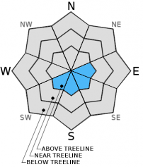
LOW avalanche danger will continue for all locations within the forecast area, all elevations and aspects.
Very small, isolated wind slabs may have formed above 9,000 ft. on leeward SW-S-SE-E aspects. Newly formed wind slabs will be shallow, small and not a major concern. Loose wet snow instabilities such as roller balls, pinwheels, and loose wet avalanches are also possible today on southerly facing aspects during the warmest parts of the day.
Normal caution is advised.


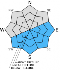
Avalanche Problem 1: Wind Slab
-
Character ?

-
Aspect/Elevation ?
-
Likelihood ?CertainVery LikelyLikelyPossible
 Unlikely
 -
Size ?HistoricVery LargeLargeSmall

Less than a tenth of an inch (0.09 inches) of precipitation was recorded at the Old Ski Bowl weather station yesterday. Light rain fell up to 9,000 feet on Mt. Shasta during the afternoon hours. This scant amount of new snow was accompanied by strong northwesterly winds that will have transported and possibly formed very small wind slabs on leeward SW-S-SE-E aspects above 9,000 feet. While worth mentioning, wind slabs will likely not reach a large enough size to pose a threat to mountain travelers. Slabs will be isolated and again, very small. Wind slabs are at their most sensitive during and immediately after the storm, though the depth of newly formed slabs will be only a few inches deep at most. For this reason we have kept the danger at low.
Avalanche Problem 2: Loose Wet
-
Character ?

-
Aspect/Elevation ?
-
Likelihood ?CertainVery LikelyLikelyPossible
Unlikely
-
Size ?HistoricVery LargeLargeSmall
Any loose wet snow instabilities will be limited to southerly facing aspects during the warmest parts of the day, today. They may take the form of roller balls, pinwheels, point-release sluff slides, or loose wet avalanches. These avalanches typically occur within the layer of wet snow on the surface of the snowpack, but may quickly gouge into deeper snowpack layers. They start at a point and entrain snow as they move down slope fanning out as they progress. They generally move slowly, but can contain enough snow to be a problem to backcountry travelers. Common areas to find these kinds of instabilities would be the SE aspect of Casaval Ridge that falls into Avalanche Gulch, the SE aspects of both Sun Bowl and Powder Bowl, and the southerly aspect of Right Peak at Castle Lake.
Forecast Discussion
High pressure will bring clear and dry weather to our area today and Tuesday with some possible night time valley fog and low clouds. Temperatures both today and tomorrow will be rather balmy for this time of year. This will be, however, our last taste of "spring like" weather conditions as a strong low pressure system approaches the region on Wednesday. This cold front will herald in a few days of wet storm systems before another break of sunshine over the coming weekend. Snow levels are predicted to start off high, around 8,000 ft., then lower to around 4,000 ft. by Thursday. We'll see what happens as we get closer to this shift in weather. Winds for today and tomorrow will be coming from a more Northwesterly direction at moderate speeds above treeline at mid-mountain levels (10,000 ft.). They will shift to a more Southwesterly flow on Wednesday with the approaching storms. Enjoy the sunshine and corn snow because a couple of powder days are on the horizon!
THIS SEASON PRECIPITATION for MT SHASTA CITY: Since October 1st (the wet season), we have received 22.62 inches of water, normal is 25.67 inches, putting us at 88% of normal. For the month of February we've received 0.13 inches of water, normal is 3.40 inches, putting us at 3% of normal, and finally... for the year of 2016 we've received 13.13 inches of water, normal is 10.46 inches, putting us at 125% of normal .
Recent Observations
Yesterday brought the first bout of inclement weather in the last week, or so. Temperatures remained mild bringing light rain all the way up to near 9,000 ft. during the afternoon hours. Northwesterly winds were blasting ridge tops, and clouds obscured the mountain above treeline restricting climbers from venturing too high into the maelstrom. A ski tour up Avalanche Gulch to just above treeline revealed soft, wet surface snow and sticky ski conditions. The unusually dry conditions and warm temperatures for February have helped to consolidate the snowpack and limit any avalanche instabilities over the forecast area. The sunny and mild conditions on tap for today and tomorrow will continue this trend. As the clouds parted during the early evening yesterday they allowed an escape route for thermal energy built up in the snowpack to release. This radiational cooling will help the soft snow to firm up, and encourage the melt/freeze cycle to occur. Any refreeze will be superficial and quickly melt as the day warms up. What will be left are variable snow conditions, especially above 9,000 ft. Ridge tops will be wind scoured and icy, or breakable crust. Snow below treeline will get sticky in the afternoon hours. Some decent corn snow conditions may be found, as well, in places like Sun Bowl or Powder Bowl.
For today, normal caution is advised. For those who venture to mid-mountain elevations and higher keep your eyes peeled for very small wind slab formations in steep, isolated areas on leeward SW-S-SE-E aspects. Southerly facing aspects may host loose wet snow instabilities in the form of roller balls, pinwheels, and point-release sluffs during the warmest parts of the day, both today and tomorrow. While not much of a threat themselves, they could push you off your feet, over a cliff, into trees or rocks, into a terrain trap, etc. Use normal safe travel techniques.
________________________________________________________________________________________________________________________________________
LOCAL AREA ROAD, NORDIC and SNOWMOBILE PARK STATUS:
The Sand Flat cross country ski trails are in great shape and ready for your cross country skis or snow shoes. These are backcountry trails marked with blue diamonds on trees. Trails are not groomed. Snow shoers, please blaze a parallel trail to cross country skiers staying out of the skin track. These trails can be accessed via the Everett Memorial Highway. Thank you, and enjoy!
The Mt Shasta Nordic Center is open! These beautiful, groomed trails can be accessed via the Ski Park Highway. http://www.mtshastanordic.org
The Pilgrim Creek & Deer Mountain Snowmobile Parks are open! Trails are being groomed currently. Head to our "Education" tab on our website and find the snowmobile section for trail information, grooming status and other sledder resources!
The Castle Lake road is plowed to the lake. The Everett Memorial Highway is plowed to Bunny Flat.
The Five Red Flags of Avalanche Danger any time of year include: 1) Recent/current avalanche activity 2) Whumphing sounds or shooting cracks 3) Recent/current heavy snowfall 4) Strong winds transporting snow 5) Rapid warming or rain on snow.
Weather and Current Conditions
Weather Summary
Good Morning! In Mt Shasta City at 0500, we have a current temperature of 37 F, nine degrees cooler than yesterday at this time. Skies are clear with calm winds.
On Mt Shasta (South Side) in the last 24 hours...
Old Ski Bowl - 7,600 feet, the current temperature is 38 degrees F. Snow on the ground totals 104 inches with no new snow and 3 inches of settlement. Temperatures have ranged from 34 F to 44 F.
Grey Butte - 8,000 feet, the current temperature is 34 degrees F. Temperatures have ranged from 32 F to 41 F. Winds have been averaging 35-40 mph until 3 pm yesterday, then lowered to 5-10 mph, north/northwest then shifting to southeast in direction with a max gust to 71 mph, NNW.
Mt Eddy Range (West side of Interstate-5)...
Castle Lake - 5,600 feet, the current temperature is 39 degrees. Temperatures have ranged from 37 F to 43 F. Snow on the ground totals 58 inches with no new snow and 2 inches of settlement.
Mt Eddy - 6,500 feet, the current temperature is 39 degrees F. Temperatures have ranged from 38 F to 43 F. Snow on the ground measures 74 inches with no new snow and 3 inches of settlement. Winds have averaged 4 mph, southeast in direction with a max gust of 26 mph, southeast.
Always check the weather before you attempt to climb Mt Shasta. Further, monitor the weather as you climb. Becoming caught on the mountain in any type of weather can compromise life and limb. Be prepared.
| 0600 temperature: | 36 |
| Max. temperature in the last 24 hours: | 44 |
| Average wind direction during the last 24 hours: | North/northwest shifting to Southeast |
| Average wind speed during the last 24 hours: | 35-40 mph then lowering to 5-10 mi/hr |
| Maximum wind gust in the last 24 hours: | 71 (Grey Butte) mi/hr |
| New snowfall in the last 24 hours: | 0 inches |
| Total snow depth: | 83 inches |
Two Day Mountain Weather Forecast
Produced in partnership with the Medford NWS
| For 7000 ft to 9000 ft | |||
|---|---|---|---|
|
Monday (4 a.m. to 10 p.m.) |
Monday Night (10 p.m. to 4 a.m.) |
Tuesday (4 a.m. to 10 p.m.) |
|
| Weather | Sunny | Mostly clear | Mostly sunny |
| Temperature (°F) | 50 | 37 | 52 |
| Wind (mi/hr) | North 5-10 mph | West 5-10 mph | Southwest 5-10 mph |
| Precipitation SWE / Snowfall (in) | / 0 | / 0 | / 0 |
| For 9000 ft to 11000 ft | |||
| Monday | Monday Night | Tuesday | |
| Weather | Sunny and windy | Mostly clear and windy | Mostly sunny and windy |
| Temperature (°F) | 36 | 33 | 33 |
| Wind (mi/hr) | Northwest 30-35 mph with higher gusts | West 0 | West 25-30 mph with higher gusts |
| Precipitation SWE / Snowfall (in) | / 0 | / 0 | / 0 |

